The Tormore field was discovered in 2007 by Total (205/5a-1). The well found gas. In 2010, Total decided to develop the field in conjunction with the Laggan gas discovery to the northeast. However, only after the final investment decision was made to build a gas plant and associated pipeline, Total found oil in the first Tormore appraisal well drilled in 2013 (205/5a-T2Z).
Despite this, the operator got the go-ahead to only produce the gas. This must probably be seen in the context of the major investment to put a pipeline in place all the way to the Shetland Islands.
The oil in Tormore has mostly been portrayed as an oil rim, leaving the impression that the field should be regarded as a gas field first and foremost. In a paper recently published by Clark and co-workers (see full reference below), Tormore is introduced as a gas-condensate field, with only later in the abstract the addition that it has a saturated oil rim.
Is the “oil rim” claim valid, or should the field be regarded as an oil field with a gas cap instead?
Based on the data published in the paper, we have made a reconstruction.
Tormore drilling history
As the map below shows, the first well on Tormore (205/5a-1) was drilled in the gas zone, targeting a high seismic amplitude. It encountered 27 m of gas condensate-bearing net reservoir in Paleocene turbidite lobe sands.
The gas-oil contact is interpreted at 3785 m TVDSS, just sitting below the base of the last sand drilled by 205/5a-1. However, in the absence of gas and oil bearing sands in this well as well as subsequent wells the contact must be regarded as an assumption.
The first appraisal well was 205/5a-T2Z, further to the northwest. All four Paleocene sands drilled in this well were found to be in the oil zone, which according to Total ranges from 3785 to 3940 m TVDSS.
As a consequence of the findings in T2Z, the third well (205/5a-T3) – which has so far been the only producer – was drilled updip of the discovery well to ensure that it would only hit gas.
Now the question is how the volumes of oil and gas in the structure compare; is the claim of an oil rim valid?

Tormore oil field?
In the paper, the volume of non-associated gas is stated as being 346 bcf, which translates to 62 MMboe. At the same time, the authors estimate that there is 92 MMb of oil in place.
Only looking at these numbers, there initially was about 33% more oil in Tormore than gas. For that reason, one would suggest that Tormore should rather be classified an oil field with a gas cap than the other way round.
Having just made the investment of building a gas plant and associated infrastructure, it is understandable that Total was probably given consent to produce the gas from Tormore.
However, now that fields such as Edradour and Glenlivet have been tied back to the pipeline, is it still required for Total to keep on producing the gas and thereby reducing the pressure window to produce the oil?
The first principle in the Maximising Economic Recovery Strategy for the UK states that all stakeholders should be obliged to maximise the expected value of economically recoverable petroleum, not the volume expected to be produced.
Taking that into consideration, combined with the fact that additional gas reserves have since been added to the Laggan pipeline, would it not be appropriate to launch an economic analysis to see whether it is worth producing the Tormore oil, whilst shutting down gas production in the meantime?
Some more questions
Based on the cross-section presented here, a few more questions arise.
The paper suggests an oil-water contact of 3940m TVDSS. However, as the figure shows, none of the three wells penetrated the contact, with the T2Z calling Total Depth at 2 m above the proposed contact. This means that there is not much room for suggesting a shallower contact than suggested, but there may be room for it to be deeper until proven by another well further downdip. Therefore, the oil in place could be higher than currently estimated.
Secondly, looking in close detail at the Tormore oil-leg pressure plots in figure 13 of the paper (re-drawn in figure above), it looks as if the sands penetrated may have got three different pressure gradients rather than one, suggesting different contacts. Extrapolating the trends from these individual sands leads to intersection above the base of the gas column, which suggests that there may be a baffle between the oil and gas columns. This may in turn be an argument against oil production as it implies compartmentalisation.
Summary
In conclusion, based on the data presented in the Tormore paper recently published by Total, and the inferences made whilst analysing and illustrating the available data, it seems justified to classify the Tormore field as an oil field with a gas cap, or a mixed accumulation at best, and not as a gas field with an oil rim.
In addition, there is potential for more upside as the OWC has not yet been penetrated. However, based on pressure plots, potential of baffles may exist between the oil and gas zones.
So, an open-minded evaluation of the optimal economic development of Tormore would appear merited, incorporating the full range of uncertainty in fluid types and volumes, along with any compartmentalisation.
HENK KOMBRINK
Reference to Laggan-Tormore publication:
Clark, J., Matthews, P., Parry, C., Rowlands, M. & Tessier, A. (2020). The Laggan and Tormore fields, Blocks 206/1 and 205/5, UK Atlantic Margin. In: Goffey, G. & Gluyas, J.G. (Eds), United Kingdom Oil and Gas Fields: 50th Anniversary Commemorative Volume. Geological Society, London, Memoirs, 52, 967–979, DOI
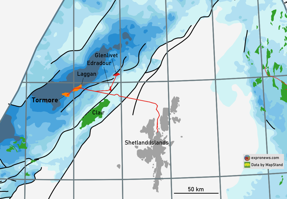
Caption featured image: Location of Tormore and Laggan fields, West of Shetland. The blue colours represent the thickness of the Paleocene succession, with the darker colours indicating a thickness of more than 2000 m.