A developing province
East Africa has undergone extension since the Neogene, as reflected in its spectacular and famous rift system. The eastern branch links to currently active structures in the coastal region, and thus is imaged in the SPAN surveys. Associated uplift of East Africa created an impressive plateau that furnished copious amounts of sediment to the coastal basins via several world-class rivers. The result was widespread deepwater fan complexes developing down slope from the major deltaic influx.
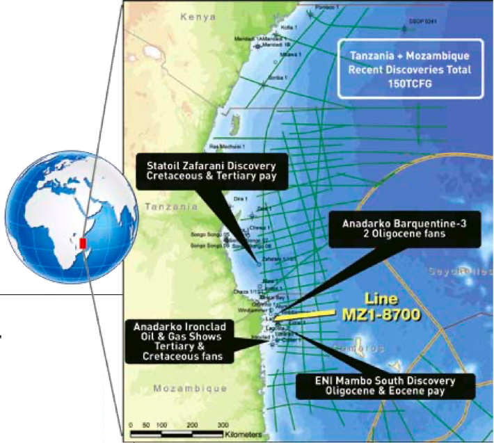
The USGS assesses resources in the East African region at 27.6 Bbo, 441 Tcfg and 13.77 Bb of natural gas liquids (Brownfield et al., 2012) including the Tanzania-Kenya and Mozambique Coastal provinces, West Madagascar and the Seychelles. At the time of writing, discoveries of approximately 150 Tcfg have been announced in Tanzania and adjacent Mozambique, making this an emerging world-class petroleum province. Exploration success rates have been remarkable, with 25 announced discoveries out of 27 offshore wells. Additional success, with the possibility of an oil-prone area, is anticipated. Leasing and drilling continues along the coast and into deeper water. The recently announced Tanzanian bid round will constitute the next exploration phase in this region.
Coastal Tanzania hosted hydrocarbon discoveries as early as 1974; the Songo Songo Field currently supplies gas to Dar es Salaam. The 1982 M’nazi Bay Field is slated for development via a second pipeline. In deepwater Tanzania there have been 7 gas discoveries (of 8 attempts) since 2010. The most recent announcements put gas reserves in Tanzania at 24 to 26 Tcfg, with more wells planned and in progress. In Mozambique, 17 of the 19 exploration wells have been completed as commercial gas discoveries by Anadarko and ENI. Much of this emerging province remains unexplored and basin modeling suggests it may yet yield discoveries of liquids.
Structure of survey area
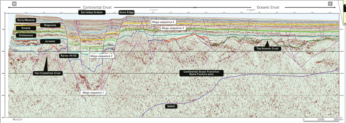
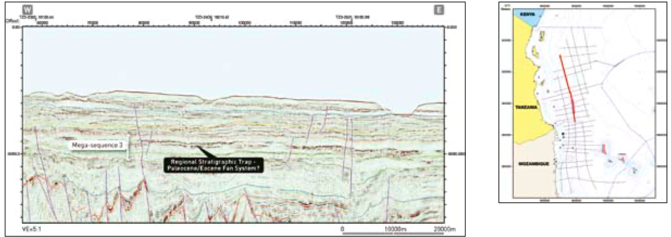
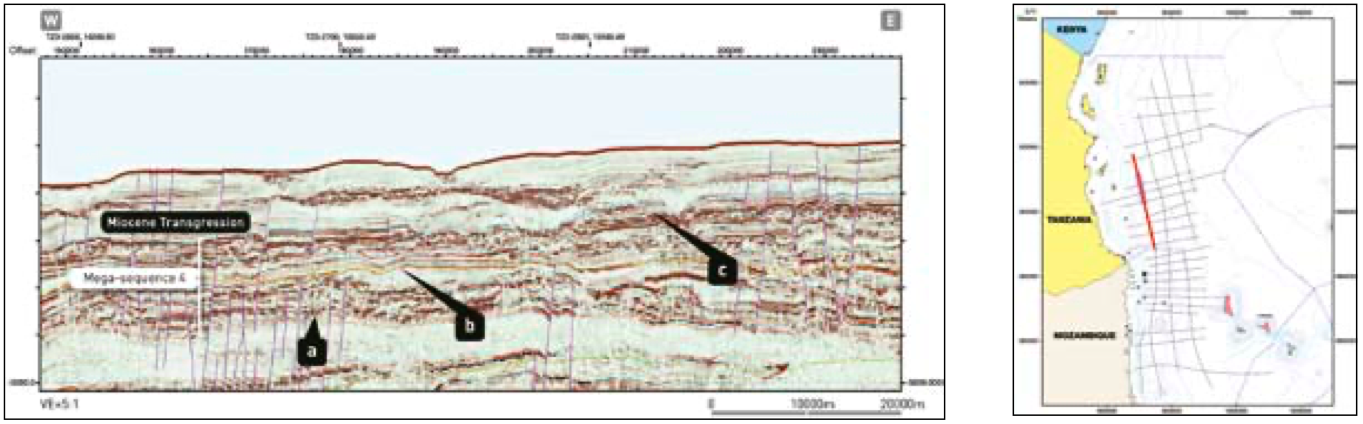
The East AfricaSPAN surveys are designed to image crustal architecture as well as structure and stratigraphy within the overlying sedimentary package. Thus, the deep parts of the lines capture classic seismic expressions of the Moho, fossil spreading centers, oceanic and continental crust transition (COT), faults bounding Karoo-age rifts and transform faults within oceanic crust (see foldout, previous page). The shallow portions of the lines show reactivated faults that cut into the overlying sedimentary package and in some cases to the ocean floor, major bounding faults along the margins of the Kerimbas Graben (see foldout), and a myriad of growth faults that cut the unstable delta lobes of the Ruvuma Basin. Any and all of these structures offer potential migration paths, as well as structural and stratigraphic trapping mechanisms.
The survey grid also allows regional-scale anticlines to be mapped. A spectacular example is the Davie Ridge, which straddles the international boundary between Tanzania and Mozambique. The structure consists of an east-plunging arch enhanced by the constructional lobes of the Ruvuma delta, which is cut to the west by the Kerimbas Graben. This immense and undrilled closure covers an area of approximately 400 by 200 km.
Prolific new petroleum system
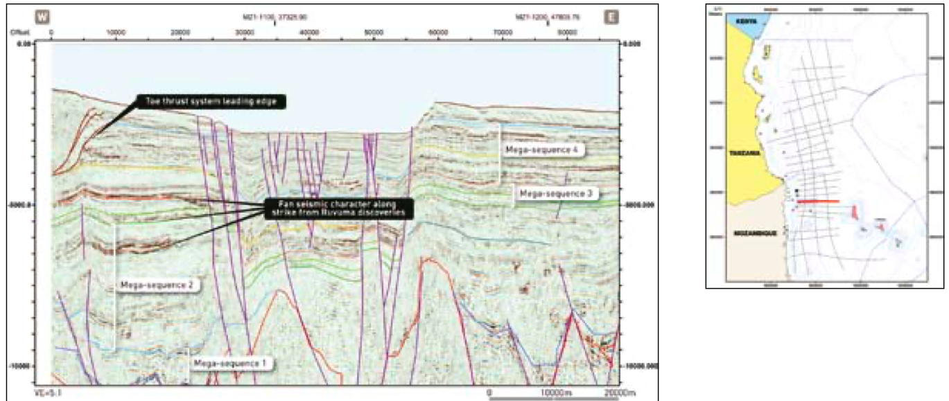
Large volumes of sediment were shed off the African craton from Late Jurassic through Miocene, punctuated by several major transgressions, leaving the critical components of a viable petroleum system present over the entire area. Multiple regressive pulses fed extensive deep sea fan complexes, which comprise current exploration targets. The resulting four tectonostratigraphic sequences reveal the basin margin evolution of offshore Mozambique and Tanzania (see foldout).
The four mega-sequences each comprise critical reser-voir/ source elements of a functioning hydrocarbon system. This configuration thus offers exploration potent ial at a minimum of four stratigraphic levels, only one of which has been tapped to date.
Play-opening deepwater reservoir systems have recently tapped into a prolific new petroleum system in offshore East Africa. Drilling targets are Tertiary and Cretaceous deepwater channel/fan systems. ION Geophysical’s East AfricaSPAN Phase III data not only highlight the regional structural and stratigraphic regime, but also discern Tertiary fan systems evolution at a remarkable level of detail.
Understanding the regional distribution of potential and proven reservoir systems, crustal type and thickness, basin evolution and heat flow across the region is essential to determining the ultimate potential of the area. Current basin models suggest that an oil play is likely in the deepwater areas, thus the next exploration phase in East Africa may prove to be even more successful.
Reference
Brownfield, M.E., Schenk, C.J., Charpentier, R.R., Klett, T.R., Cook, T.A., Pollastro, R.M., and Tennyson, M.E., 2012, Assessment of undiscovered oil and gas resources of four East Africa Geologic Provinces: U.S. Geological Survey Fact Sheet 2012–3039, 4 p.


