
Frontier play: Deep-Water Gulf of Mexico
For nearly 70 years, the sediments in the Gulf of Mexico have provided what seems to be no end for exploration targets. With new technologies to tackle deeper and deeper water depths and objectives, this trend continues. Lower Tertiary Wil- cox reservoirs have become the focus for exploration. Recent major discoveries in this trend have confirmed it to be a world-class petroleum system with a potential that could exceed 15 billion barrels of oil (2.4 billion m3) recoverable.
The Gulf of Mexico was formed as a result of seafloor spreading that started in Late Triassic and continued through Middle Jurassic time (GEO ExPro, v. 3, No. 4/5, pp 14-24; www.geoexpro.com). Since Late Jurassic, the basin has been a stable geologic province. The central Gulf has been characterized by persistent subsidence, first from thermal cooling, and later from sediment loading, as the basin filled with thick, prograding clastic wedges along its northern margins.
Widespread evaporate deposits, primarily salt, play a critical role in the movement and entrapment of hydrocarbons in the Gulf of Mexico. It was deposited in the Middle Jurassic during the time when rifting pulled North America away from the Yucatan Peninsula to the south about 200 million years ago. Being weaker and less dense than other rocks at depth, the salt moved south and upward responding to sediment loading that was prograding from the north. The upward movement of salt through the surrounding rock is responsible for most of the structures in the present day Gulf of Mexico slope area. Folding, detachment, and normal faulting of the reservoir rocks near the salt structures can be complex and difficult to image.
The Wilcox Trend
The Lower Tertiary Wilcox stratigraphic trend has been recognized since the 1930’s as an important exploration target for southeast Texas and southwestern Louisiana. Here, production is primarily gas from fluvial, deltaic, and shallow marine sandstones. It was not until Shell, Amoco, Texaco and Mobil drilled the BAHA 2 well in March, 2001, that the link between the Wilcox shelf fluvial deltaics and deep basin turbities was tested. This well was drilled in 2,375 m of water and over 400 km from the onshore producing trend. Several significant discoveries establishing the potential of this trend followed.
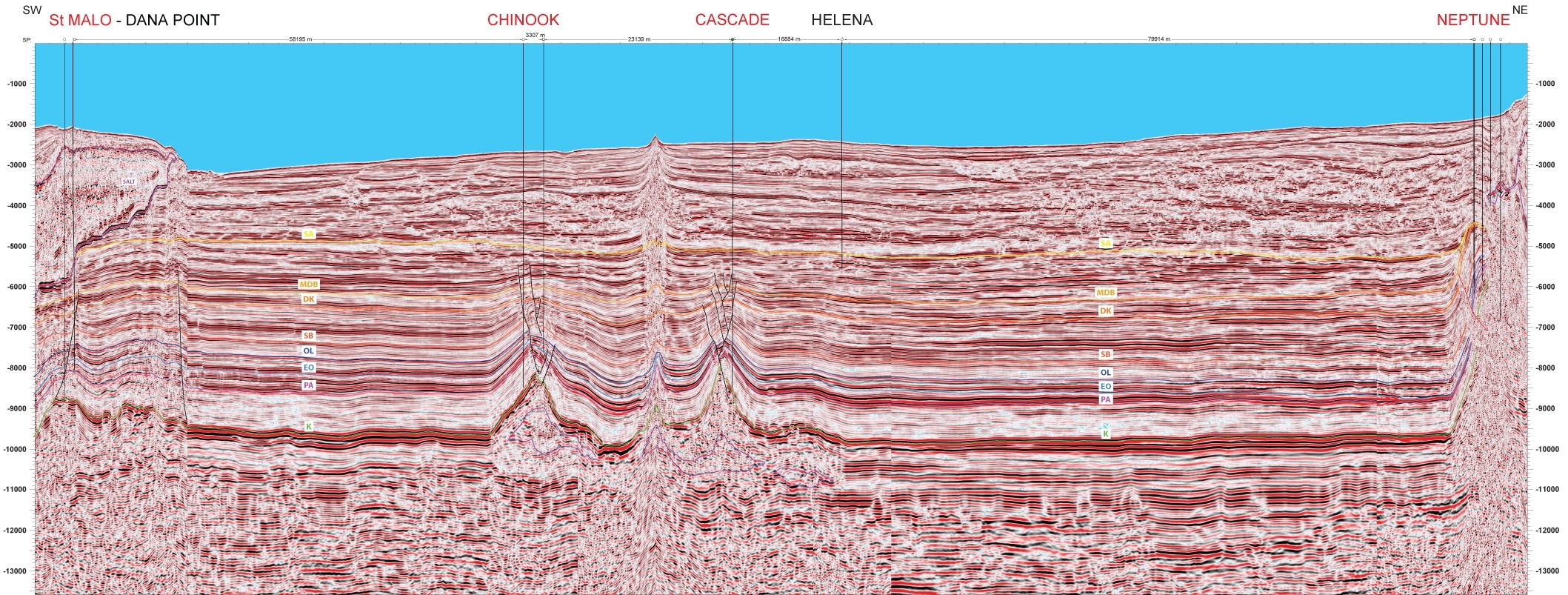
This pre-stack, depth migrated seismic section crosses the Walker Ridge area in the central Gulf of Mexico. Exploration wells are shown across the top of the section. The Cascade, Chinook, and St. Malo wells all encountered significant amounts of oil (in excess of 100 million barrels each) in the deep-water Wilcox trend between Cretaceous (K) and Paleocene (PA) geologic horizons. The Cascade well was drilled in 2482 m of water to a depth of 8,515 m. This well established the play to the east of previous wells and 560 km down dip from its deltaic source. The Chinook and St. Malo discoveries followed. Trend water depths range from 1524 m to 3049 m and objectives can be found 3000 m to more than 9000 m subsea. The reservoir rocks encountered are turbidite deposits from sheet sands to amalgamated and leveed channel systems. They are characterized by transparent seismic character that is well imaged by this pre-stack depth migrated data and are sandwiched between Cretaceous (K) carbonates and Eocene (EO) shale and limestone sequences.
The St. Malo well on the left of the seismic section shows penetration through approximately 3 kilometers of salt before encountering the Lower Tertiary oil section. The Cascade and Chinook wells found hydrocarbons in salt-cored folded structural traps.
Key geologic sequences
The imaging of the geologic features has been accomplished by employing state of the art seismic data acquisition technology, detailed velocity modeling, and special data processing algorithm. The key geologic sequences have been identified on this seismic section by integrating a global sea level fluctuation curve and fossil records. The sequences starting from the Pliocene (SA) (approximately 7 million years) to the Cretaceous (K) (approximately 70 million years old) are annotated on the seismic section. The internal characters of the rocks between these sequences offer pertinent information on oil and gas reservoirs.
The seismic section also shows shallow upper Tertiary (SB-DK) rocks where hydrocarbons have been found. The Neptune field on the northeastern side of the seismic line encountered middle and lower Miocene turbidite reservoirs in salt-cored thrust folds.


