Faults on geological maps are far more than just lines; they are a critical form of communication, conveying essential information about the Earth’s subsurface structure and tectonic history. Central to this interpretive power are fault symbols, the shorthand of structural geology. These seemingly simple lines and annotations hold a wealth of information, and their accurate use is crucial for understanding our earth and making informed decisions about its resources and hazards.
Fault symbols provide a standardized visual language for geologists to communicate the characteristics and kinematics of faults, yet it is too common to find maps with faults portrayed as simple lines. Different symbols are used to distinguish between normal faults where the hanging wall moves down relative to the footwall, reverse faults where the hanging wall moves up, strike-slip faults where movement is primarily horizontal, and in some instances, structural inversion.
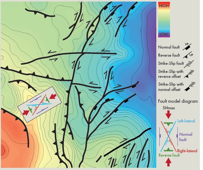
The figure shows a structure map where symbols are used to illustrate the slip sense along faults. By understanding the timing of fault movement, we can decipher the paleo – stresses and tectonic history. The fault model diagram shows expected orientations of three different fault types under a northeast – southwest directed maximum horizontal stress (SHmax). Aligning the diagram with the associated fault types on the map, helps us to decipher the paleo – stress field which has key implications to the tectonic history; a task that is only possible by reading fault symbols in the absence of other data. The absence of or inconsistencies in fault symbol conventions can lead to misinterpretations of geological structures, potentially impacting resource exploration, civil engineering projects, and hazard mitigation efforts.
But there is a disclaimer. Geoscientists may not always have the data to confidently determine the type of fault they are looking at and if this is the case, then some grace can be offered. Adding to the frustration, some mapping software applications either don’t have an option for fault symbols, or they make the process of adding them very cumbersome. However, regardless of difficulty, geoscientists should always do their best to provide this crucial information to their maps. Fault symbols are the silent language of geological maps, conveying critical information about the dynamic forces that shape our planet. Their accurate and consistent use is essential for effective geological interpretation, resource exploration, hazard assessment, and a wide range of other applications. They are not merely decorative elements on a map; they are a fundamental tool for deciphering the Earth’s secrets.