
Danish Sector revealed
Most exploration in the Danish sector has been focused within the Central Graben area
and the north-east – south-west border with Norway. The foldout on the previous page presents a 2D long-offset line acquired during a 2012 test survey. This pilot programme is an extension of TGS’s successful NSR grid into the Danish sector and line provides deeper and clearer imaging over both underexplored areas and more mature regions within the sector.
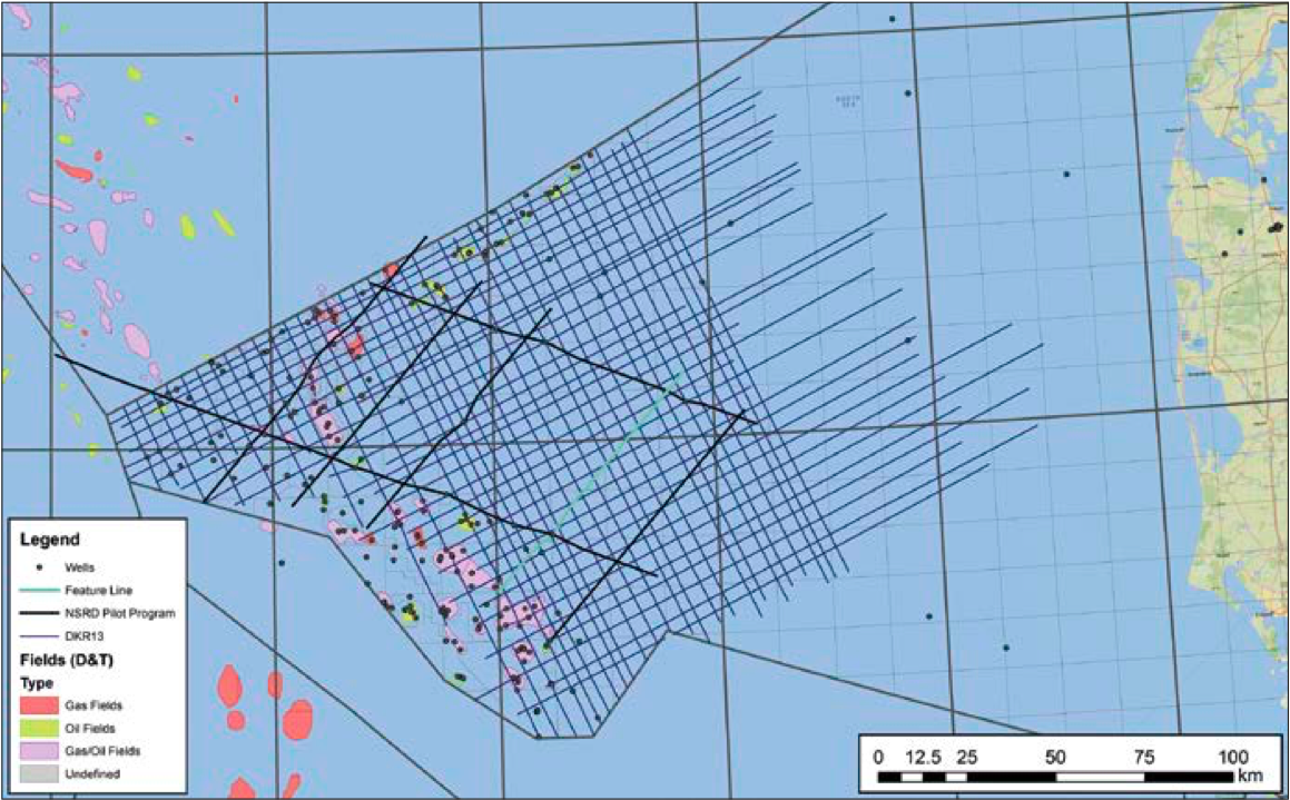
This article focuses on the areas of the Danish sector which are considered to be most prospective, yet largely underexplored. The map on the right shows the pilot programme location and current distribution of wells, discoveries and producing fields overlain on the satellite gravity data. It also shows the newly acquired DKR13 long-offset survey currently being processed ahead of the 7th Danish Licensing Round announcement.
The principal areas of current and historical exploration and production focus on the Cretaceous within the Central Graben and the Paleocene close to the north-east – south-west border zone with Norway, the Siri Fairway. However, exploration over the past ten years has resulted in the opening of a HPHT (High Pressure High Temperature) play in the Jurassic of the Central Graben. Additional prospectivity and new play concepts may also be present within the gravity lows of the high between the Central Graben and Horn Graben, here referred to as the East North Sea High (ENSH) to the east of the Coffee Soil Fault, an area which is underexplored and difficult to image. These pre-Mesozoic basin areas are currently receiving increased attention from the petroleum industry. A detailed discussion of the Palaeozoic petroleum system can be found in Pedersen, 2007. It is clear though that better understanding of the deeper structural framework from new long-offset seismic will assist in the assessment of early rifting, basin evolution and prospectivity.
Significant potential
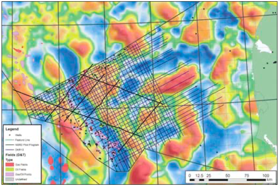
The line presented on the foldout has been chosen for its imaging of the deeper section, specifically the Jurassic of the Central Graben and the pre-Permian sections of the basins delineated by the gravity map on the ENSH, highlighting the significant potential of this dataset for exploration and regional understanding. Danish Central Graben Jurassic-Cretaceous structural evolution and basin formation has been discussed by many authors (Møller and Rasmussen, 2003), but there has been less focus on the earlier Carboniferous to Permian rifting. Good insight on this earlier rifting comes from the 26s TWT MONA LISA lines discussed in Lyngsie and Thybo (2006) and Viejo et al. (2002) and references therein. These lines image the deeper structure at the near basement level, influencing the development of the trapping structures seen on the presented seismic foldout.
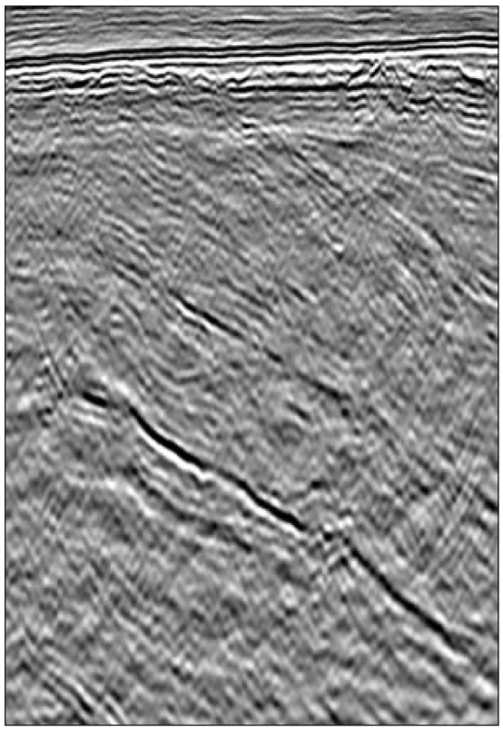
The newly available data represents a significant uplift in imaging of the offshore Danish sector area over existing exploration seismic data and the specialist research data. The presented line images up to 2.5s of Palaeozoic sediments in the gravity lows of the ENSH area. Large tilted fault blocks approximately 15–20 km on section highlight the potential for more well developed trapping structures beneath the BCU. The sediments within the tilted fault blocks are proven to contain a Permian section (Luna-1 well) but also probably comprise Carboniferous (as evidenced from seismic analogues close to the Danish- Norwegian border) and older Palaeozoic strata. A significant proportion of this is likely to be Silurian clastics sourced from the Caledonian Highlands. The shallower section shows wedges of potentially syn-rift Permo-Carboniferous stratigraphy and an unconformity identified as Permian in age in Viejo et al. (2002). Basins on the gravity map to the north and south of the basin intersected by this line may also contain structured sediments of a similar age.
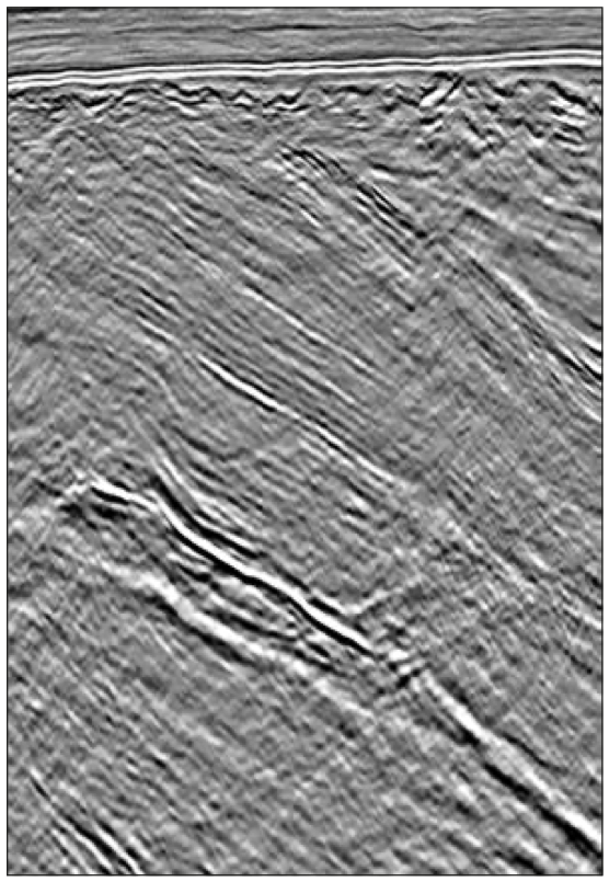
The Jurassic and deeper section in the Central Graben has also been targeted in the pilot programme and the new DKR13 survey. This follows increased industry interest in the HPHT prospectivity in this region. Over the last 10 to 15 years wells such as Hejre, Gita, Maja and Svane have all proven successful in Jurassic sands of the HPHT terrain sourced from the Farsund Formation, while Middle Jurassic coals prove the existence of two petroleum systems (Petersen et al., 2000, 2010). Hejre-1 and Svane-1 prove good reservoir porosities at depths approaching 5.5 km (Johannessen et al., 2012), indicating the significant current and future potential of these plays and the need for more data to support understanding of the development of the petroleum systems.
The new data described in this article provide explorationists with access to a previously unseen level of detail within the major structural features of the Danish sector. The test line survey was the precursor to a new 8,500 km, long-offset 2D survey, DKR13, acquired during summer 2013. The new dataset will benefit from processing workflows developed during the test line programme.
Seismic processing
Initial passes of noise attenuation in different time-offset domains were applied to target the removal of coherent and incoherent noise. Once the dataset was relatively clean of incoherent noise, TGS’ Clari-FiTM technology was applied to de-ghost the data, removing the source and receiver ghost notches seen in the amplitude spectra. The corresponding enhancement of low frequencies towards the first notch at 0Hz significantly improved the imaging of the Permo-Carboniferous section.
Due to the shallow water depths in this region (typically 30m), the data suffered from strong, short-period water layer reverberations. These were attenuated during the Clari-Fi de-ghosting process, which includes a ‘giant’ statistical deconvolution averaged over a large number of shot points and common slowness planes.
Once the data were de-ghosted, further multi-domain noise attenuation was applied which consisted of velocity-driven muting in both the shot tau-p and receiver tau-p domains. Following this, hi-resolution Radon de-multiple was applied and another pass of noise attenuation performed prior to pre-stack Kirchhoff time migration.
A second pass of hi-resolution Radon de-multiple was performed post migration, followed by additional noise attenuation prior to amplitude inverse-Q correction. Internal multiples, generated within the high velocity chalk layer and having little residual moveout, were addressed through a targeted technique in the offset domain prior to final stack. Post stack processing was limited to time-variant scaling and targeted dip enhancement.
New dataset
Considerable improvements have been seen during the processing of the test lines, allowing TGS to develop better processing sequence focused on the deeper Jurassic section in the Central Graben and the pre-BCU sequence in the ENSH area. DKR13 is the first modern long-offset, regionally consistent seismic survey in the Danish Sector, which will be an important tool for explorationists for the upcoming 7th Licensing Round.


