Dalmatia: Where Karst Meets Coast
Dalmatia is the name given since Roman times to the Balkan Peninsula’s mountainous west coast. Those mountains, the Dinarides (also called the Dinaric Alps), are a series of roughly parallel south-east trending ranges that stretch from Slovenia’s Julian Alps in the north, through Croatia and Montenegro, to Albania in the south. They constitute a fold and thrust belt produced by continental collision between Eurasia and Adria, a microcontinent that separated from Africa during the closure of the Tethys Ocean. That collision produced the Alps and Apennine ranges in addition to the Dinarides. Italy’s east coast and Croatia’s Istrian peninsula, along with the floor of the intervening Adriatic Sea, constitute the microcontinent, which is being thrust beneath Eurasia to form today’s Dinaride fold and thrust belt.
Location map. (Modified from Mosecak et al., 2018).
The Dalmatian coast features dozens of significant islands and more than 500 islets. Croatia, where most of Dalmatia is situated, is not a large country; the straight-line distance between its coastal extremities is a mere 526 km, but thanks to the region’s many islands, it boasts a coastline stretching more than 5,800 km. Dalmatia’s islands are a product of its collisional setting; the sea has inundated the fold and thrust belt, drowning the synclines, whereas the anticlines stand as echelons of long, narrow islands. Collision began in the Eocene and continues today. Convergence is proceeding at a rate of 4.5 mm/yr.
During the Mesozoic, both the Eurasian and Adrian margins of the Tethys were blanketed by thick sequences of shallow marine carbonates, which were folded and thrust up to form the Dinaride mountains. Because the range consists almost exclusively of those carbonates, karst features abound; in fact, the term karst is derived from Slovenia’s Kras plateau, which rises a short distance north-west of Dalmatia. Dalmatia’s karst topography combines with its dry Mediterranean climate to make flowing rivers rare commodities. But the springs where water exits the limestone form scenic wonders that leave an indelible impression on travellers to this idyllic land.
‘Fjords’ and Fortified Cities: Southern Dalmatia
Dubrovnik, nicknamed the ‘Pearl of the Adriatic’, is an excellent place to begin your tour of Dalmatia. Dubrovnik rose in 1358 to become a powerful independent city-state known as the Republic of Ragusa. Its wealth stemmed from its prominence in maritime trade, which reached a zenith in the 14th and 15th centuries. Thanks to skilful diplomacy, Ragusa maintained its independence until 1808, when it fell to the armies of Napoleon. In 1991, near the beginning of the protracted wars that sundered Yugoslavia, the Yugoslav National Army laid siege to Dubrovnik for eight months. The Stradun, Dubrovnik’s main promenade, hosts colourful market stalls by day and, on warm summer nights, tables for candle-lit dinners amidst the city’s medieval ambiance. The Old Pharmacy, which has been in business since 1317 and hosts an interesting museum, stands in the courtyard of a Franciscan monastery just off the Stradun. Keen walkers will delight in circumambulating the old city atop its thick limestone walls, peering down on the town’s beautiful churches, palaces, and homes, all bedecked with orange tile roofs. The city was almost completely destroyed by a magnitude M=7 earthquake in 1667, so most of the public buildings you see were rebuilt after that date, accounting for the city’s primarily Baroque architecture. For an even loftier perch, with expansive views of the city below and the Dalmatian islands to the north-west, hike or take the cable car up Srd, the almost 400m-high hill that rises behind Dubrovnik.
Dubrovnik from the start of the Srd hill climb. © Lon Abbott/Terri Cook.
Montenegro’s Bay of Kotor, often mistakenly called Europe’s southernmost fjord, is southern Dalmatia’s other scenic highlight. You’ll see why so many people call it a fjord when you drink in the views of its steep, imposing limestone mountains that plummet to a narrow inlet of the sparkling Adriatic Sea on the 92 km drive there from Dubrovnik. Although the Bay of Kotor strongly resembles a fjord, it was not carved by a glacier, so it is technically a ria. Like all rias, this impressive bay was instead created when rising sea levels drowned an ancient river valley. Like the drowned synclines that separate Dalmatia’s anticlinal islands from the coast, the bay is a product of downward lithospheric flexure in the active collision zone.
Thanks to the protection from storms the ria affords to ships, Kotor was an important harbour and trading hub throughout the Middle Ages. The town was variously controlled through the centuries by the Serbs, the Venetians, and the Ottomans, with most of the old city’s present charming appearance owing to buildings constructed during the four centuries of Venetian rule. The medieval city is encircled by a 4.5 km wall 20m high that ranges in thickness from 2 to 16 metres. Wandering through the old town’s labyrinth of cobblestone streets or ascending the fortified ramparts to Castel St John is delightful. The French occupied Kotor for most of the 19th century, followed briefly by the Austrians and then, in 1918, the city became part of Yugoslavia. In 2006 the Montenegrins voted for independence from Serbia, marking one of the final acts in the disintegration of the former Yugoslav Republic and establishing one of Europe’s youngest nations.
The Bay of Kotor. © Lon Abbott/Terri Cook.
Kotor’s fortifications are quite possibly the world’s best surviving example of medieval Venetian defensive architecture, which the United Nations recognised by inscribing the old town on UNESCO’s World Heritage list in 1979, the same year that much of Kotor was damaged by a M=7.1 earthquake that nucleated on the frontal thrust about 60 km south of the bay. Since 2001, the European Commission has funded restoration efforts, resulting in today’s charming tourist destination. For a stunning bird’s-eye view of Kotor, drive the ‘ladder of Kotor’, a paved road that ascends 25 hairpin bends up the karst-riddled limestone mountain behind the town, topping out at a 1,100m pass.
Rugged Islands and a Roman Palace: Central Dalmatia
The southernmost Dalmatian islands rise just north of Dubrovnik. One of the most enjoyable aspects of exploring the Dalmatian Coast is discovering each island’s distinctive character and history. Mljet, the southernmost major island, is one of the least developed and most relaxing. One attraction, courtesy of karst, is Odysseus’s Cave, which is a popular swimming spot. Its name stems from the claim that this is where Odysseus was shipwrecked and held captive for seven years by the nymph Calypso.
North of Mljet lies Korcula island, famous for its wine and its dense pine forests. You can get there by ferry direct from Dubrovnik or access it along the coastal road north from Dubrovnik, from which you are treated to spectacular island views, especially at sunset. Fifty km north of Dubrovnik, the route to Korcula traverses the narrow Peljesac Peninsula, which exudes an island vibe without the hassle of a ferry ride. Slowly driving or biking the scenic, 57 km road between Ston and Orebic, the peninsula’s two main towns, stopping at vineyards along the way is a real treat. A half-hour ferry ride from Orebic deposits you in Korcula town, nicknamed ‘mini-Dubrovnik’ because its medieval walls and orange tile roofs have the same charming ambiance. The delta of the Neretva River, the largest to reach the sea between Dubrovnik and Split, the next major town to the north, lies a further 41 km up the coast. It is well worth the 54 km-long detour up the Neretva, crossing into the country of Bosnia and Herzegovina to visit the town of Mostar. Unfortunately, Mostar’s fame lies with the suffering its inhabitants endured during the breakup of Yugoslavia. The town’s namesake bridge, the Stari Most (old bridge), was destroyed in the fighting. When the arch bridge was built in 1557, under orders from the Ottoman sultan Suleiman the Magnificent, it had the world’s longest span. The sultan threatened its architect, Mimar Hayruddin, with death if the bridge collapsed, so Hayruddin is said to have planned his own funeral on the day the bridge was finished. But the elegant limestone span held until 1993, garnering fame among travellers for its beauty and functionality. Reconstruction of the bridge in the original style was completed in 2004, providing a platform for cliff divers who perform the 24m leap into the river for tips. While in the area, don’t miss the Vrelo Bune spring, one of Europe’s largest, 7 km south of Mostar. Here, 30 m3/sec of water pours out of a cave at the base of a limestone cliff, with an attractive, architecturally simple, Sufi monastery nestled next to it. This serene spot feels well off the beaten tourist track.
Vrelo Bune spring and monastery. © Lon Abbott/Terri Cook.
Hvar is the island of choice for well-heeled sailors, who moor their yachts in the Stari Grad (old town) harbour. Stunning views of the harbour and nearby islands can be had from the 16th-century, Venetian-built citadel above town. You can visit Brač, Dalmatia’s largest island, from Hvar or on a one-hour ferry ride from Split. The southern Brač town of Bol boasts Zlatni Rat, one of the country’s best white sand beaches; most Dalmatian beaches consist of cobbles, because limestone isn’t conducive to producing sand-sized detritus. Brač is most famous, however, for its gleaming white, coarse-grained limestone. Highly prized in the building trades, Brač limestone was used to construct many important buildings, from Diocletian’s Palace in Split to the White House in Washington, D.C.
With a population close to 200,000, Split is Dalmatia’s largest city. The city’s main attraction is Diocletian’s Palace, the sprawling retirement home of the Roman emperor. Diocletian abdicated the throne in 305 CE, the first Roman emperor ever to do so. Palace highlights include the cellars, the peristyle, and the cathedral of Saint Domnius. The cavernous cellars are one of the world’s best-preserved examples of ancient underground architecture. Diocletian’s quarters opened onto the peristyle, a column-lined central courtyard. Many of the pillars are made of local limestone, but Diocletian, who developed a fondness for Egyptian art during military campaigns he waged there, also imported columns of Egyptian granite, as well as a sphinx carved from jet-black gabbro.
Karst’s Magnum Opus: Northern Dalmatia
Dalmatian karst geology reaches its scenic crescendo north-west of Split, thanks to the greater abundance there of water, with its power to dissolve and reprecipitate limestone. The stunning Skradinski Buk waterfalls cascade over travertine ledges precipitated out of the carbonate-saturated water of the Krka River just off the main E65 highway about 100 km north-west of Split. They are the lowest of seven travertine waterfall complexes in the Krka National Park. The lower 23 km of the Krka River, downstream from Skradinski Buk, was drowned by sea level rise after the last glacial maximum, forming another long Dalmatian ria.
The area between Split and Zadar is topographically subdued by Dalmatian standards, with the highest peaks not quite reaching 500m elevation. That changes north of Zadar, where the 1,600m peaks of the Velebit mountains, Croatia’s most extensive range, crowd the coastline. Two national parks preserve the most dramatic portions of this range: Paklenica National Park is famous for rock climbing on sheer limestone cliffs and for its more than 115 caves, including regular tours of the Manita Peć show cave. North Velebit National Park boasts Croatia’s deepest cave, Lukina Jama, at 1,431m deep. It is also a hiking paradise. Premužić’s Trail, named for the man who built it in 1933, is the most popular, thanks to the impressive views it affords down to the northern Dalmatian islands along its 57 km-long meander across the karst plateau. The walk gives hikers a top-of-the-world feeling despite its gentle inclines.
Plitvice’s travertine dams. © Lon Abbott/Terri Cook.
Waterfalls at Plitvice. © Lon Abbott/Terri Cook.
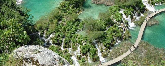
As beautiful as all these parks are, it is Plitvice (PLEET-veet-say) Lakes National Park, 120 km inland (and so not in Dalmatia proper), that boasts Croatia’s most magnificent karst scenery. Plitvice is best known for waterfalls that tumble over travertine dams into emerald and turquoise pools, with water so clear you can see scores of fish darting in its depths. Plitvice’s abundant travertine dams form where slight agitation of the water promotes the escape of dissolved carbon dioxide. That loss reverses the chemical reaction that dissolved the limestone in the first place, causing calcite to precipitate out of the water as travertine. Bacterially mediated chemical reactions assist in the precipitation. The addition of new travertine slowly modifies each lake and waterfall, continually reshaping Plitvice’s ever-changing vistas.
A sombre aspect of Plitvice’s history is that it was here, on Easter Sunday 1991, that the first shots were fired in Croatia’s War of Independence from Yugoslavia, resulting in the war’s first fatality. Here, as in Mostar and Dubrovnik, monuments memorialise those who perished in the strife triggered by the dissolution of the former Yugoslavia. Although the people of Dalmatia still carry scars from this recent conflict, they welcome visitors with open arms and a broad smile. They are proud to show off their picturesque homeland. Once you’ve traversed this land where karst meets the coast, you’ll see clearly the source of their pride, and you’ll most likely be planning a return visit before you’ve even departed.


