A new regional framework for exploration offshore Côte d’Ivoire
State-of-the-art re-imaging provides fresh insights into the prospectivity of the Tano Basin
The Tano Basin along the Côte d’Ivoire and Ghana shelf has been well explored with various phases of seismic data acquisition and drilling activity since the 1970s. Oil production began in the early 2000s with the Espoir field, followed by further field developments in Côte d’Ivoire. The discovery of the Jubilee field in Ghana in 2007 kick-started an intense exploration campaign across the Equatorial margin of Africa. Exploration beyond 2,000 m water depths offshore Côte d’Ivoire began in 2011, with discoveries such as Paon and Pelican proving the extension of the Late Cretaceous plays into the distal parts of the Tano Basin. The play-opening 2021 Baleine discovery (a carbonate shelf edge play) – the largest discovery made to date along the Ivorian margin – transformed the country’s production outlook with estimated volumes of 2.5 BBO of oil and 3.3 Tcf of associated gas. This was followed by the second largest discovery, Calao (Murene-1X), in 2024. These discoveries have attracted renewed exploration interest in the offshore of Côte d’Ivoire, with recent exploration acreage awarded to several IOCs, making it a current exploration hotspot.
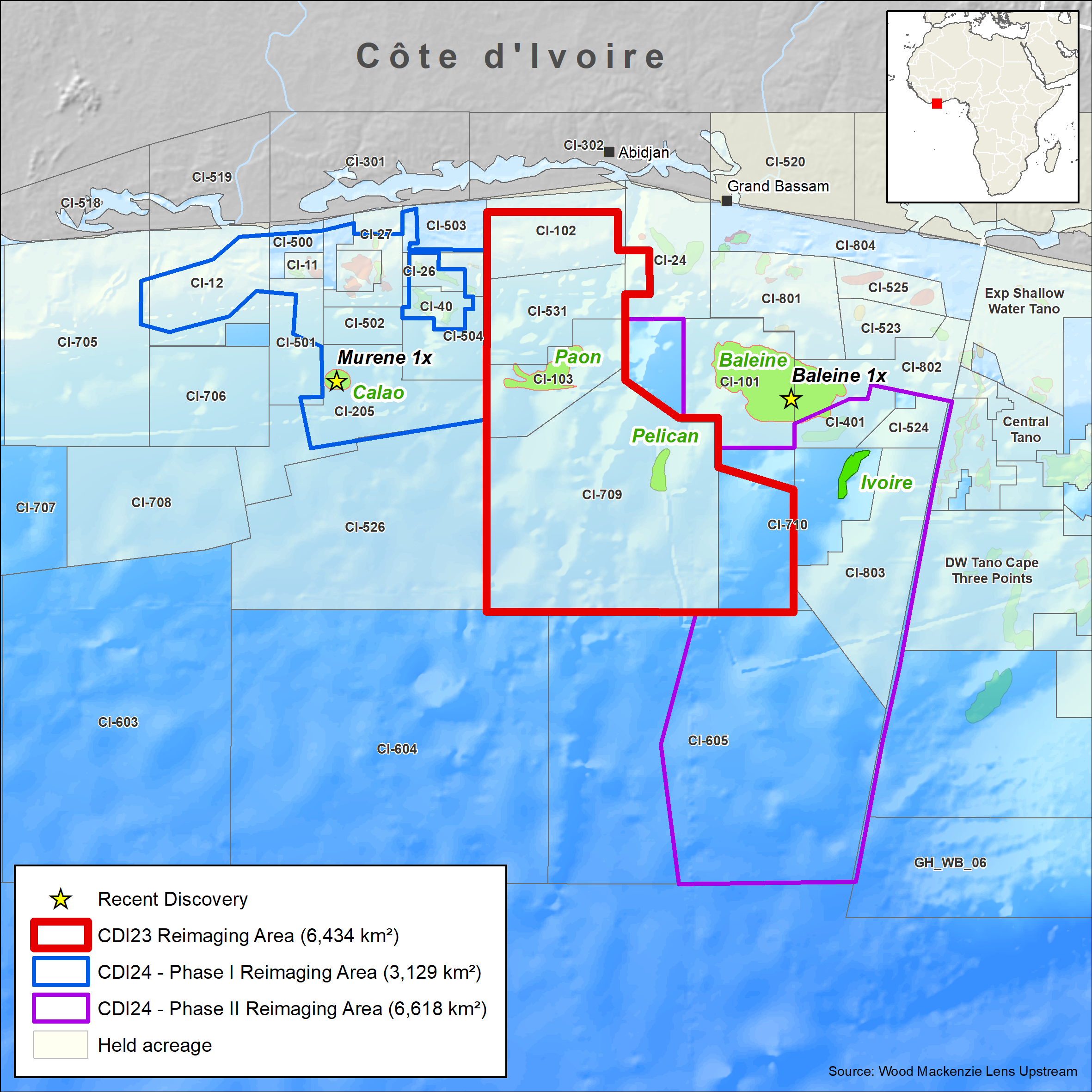
Viridien, in association with Direction Générale des Hydrocarbures (DGH) and PETROCI Holding, is re-imaging a significant portion (up to 16,000 km2) of the Ivorian margin to provide the industry with a solid foundation to build a regional understanding and de-risk the play potential of the Tano Basin. The program overlaps with the recent Calao discovery (Murene-1X) and is adjacent to the world-class Baleine field.
Cutting-edge technology brings imaging uplift
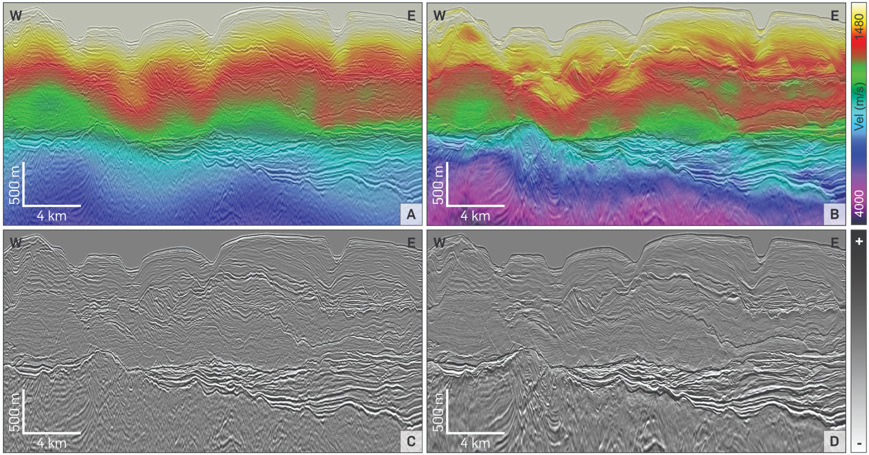
This article presents Viridien’s fast-track results from the CDI-23 multi-client 3D PSDM re-imaging project (6,434 km2) which consists of four separate surveys acquired over multiple blocks between 2000 and 2014 from the shelf to the outer slope domain. These four surveys were merged to create a contiguous seismic volume that had differing cable depths and streamer profiles, along with significant variations in legacy processing workflows. The new re-imaging was undertaken from field tapes using proprietary state-of-the-art technologies such as ghost wavefield elimination (GWE), advanced demultiple, and time-lag full waveform inversion (TL-FWI) velocity model building.
The fast-track 3D volume shows a significant imaging uplift compared to the legacy data (Figure 1). This is due to greater bandwidth and a more detailed velocity model, enabling better imaging of the basin architecture, enhanced resolution and delineation of faults, as seen in the foldout section, and improved imaging of Cretaceous reservoir intervals.
Tano Basin at a glance
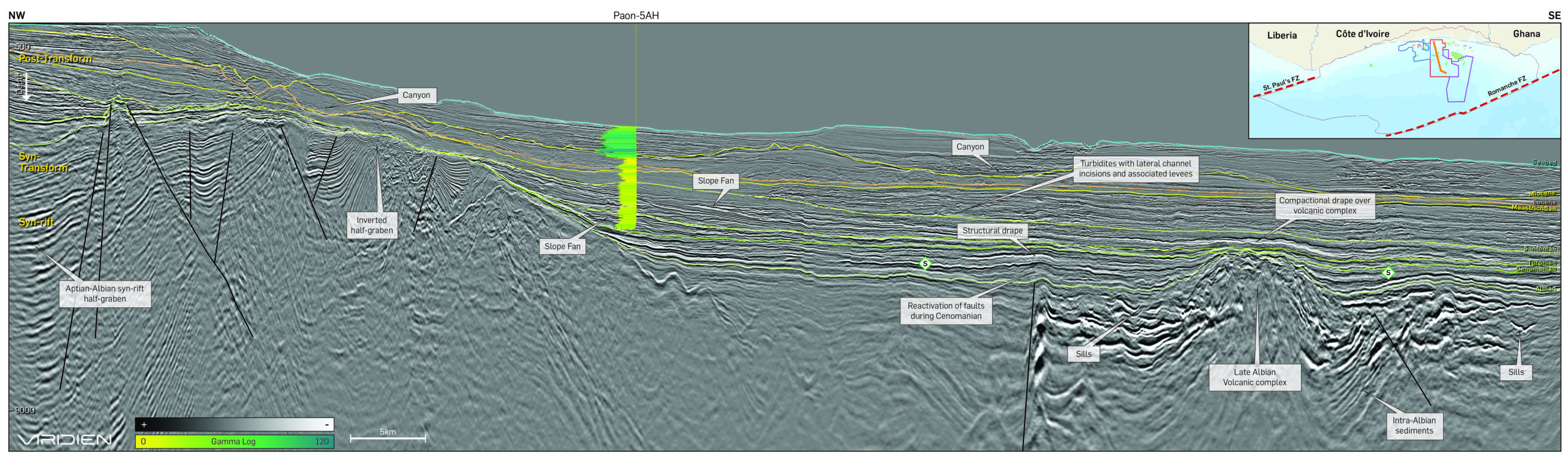
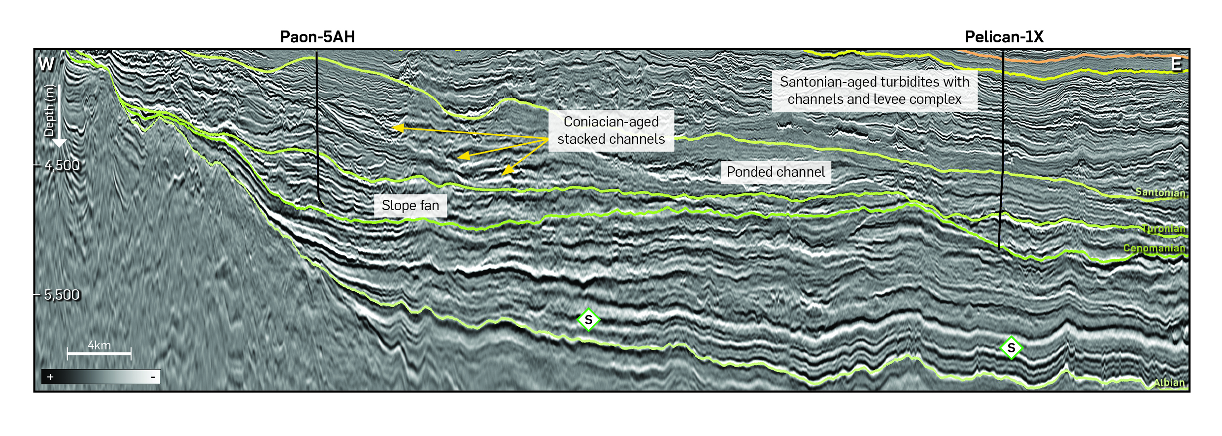
The CDI-23 re-imaging program is located on the transform margin of the Tano Basin between the Romanche Fracture Zone in the west and the St Paul’s Fracture Zone to the east. The basin formed due to dextral-oblique divergence between Africa and South America. During the Aptian – early Albian, pull-apart rifting formed rotated fault blocks and individual grabens and half-grabens filled with various continental and marginal marine sediments as observed in wells such as Baobab-1. From the mid-Albian, the basin entered a transform phase with formation of crustal, oblique-slip faults and en-echelon folds (Scarselli et al., 2018). Crustal weakening along these large faults controlled the emplacement of the mid-to-late Albian volcanic centres and sub-volcanic sill complexes. Further strike-slip movement in the Cenomanian resulted in the inversion of existing structures. This had an important control on the deposition and trapping of the lower Late Cretaceous turbidite reservoirs but also created migration pathways for hydrocarbons. Carbonate deposition also occurred over crests of fault blocks as seen in the world-class Baleine Field. The upper Late Cretaceous-to-present, post-transform phase sediments were deposited in a deep marine setting with ponded and channelised turbidite systems, basin floor fans, contourites or off-axis hemipelagites, all of which are imaged exceptionally well in the fast-track seismic data (Figure 2).
Exploration of the Tano Basin has proven a highly effective working petroleum system (Paon, Pelican and Baleine wells). Regional primary source rocks include the Albian, Cenomanian and Turonian shales with present-day optimal maturity across the basin.
New geological insights
This regional fast-track PSDM dataset is a valuable tool for seismic interpretation and attribute analysis of the highly complex and variable Cretaceous section. The features of the depositional architecture can be identified and mapped, including the presence of leveed channel complexes, slope and basin floor fans and a series of sediment waves. Root mean square (RMS) amplitude extraction along stratigraphic slices through the Late Cretaceous interval are particularly revealing as seen in Figure 3. Figure 3a shows an Early Turonian stratal slice with a high sinuosity channel system that fully traverses the survey and crosses an area with well-defined sediment waves that may represent contourites, whilst Figure 3b shows a Late Turonian stratal slice with three distinct sediment transport pathways with channels widening into fans to the southwest. Additionally, multiple sediment transport pathways and deepwater sediment dispersal systems are identified that extend through the entire AOI and into the deeper basin.
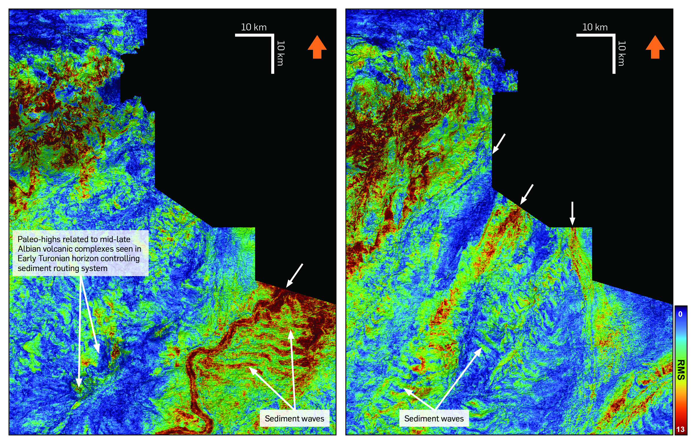
The variability in depositional elements and their organisation is merely a snapshot of the complex stratigraphic evolution during the Late Cretaceous, with offset stacking and routing around structural highs meaning the reservoir is widely distributed across the area.
What’s next?
The CDI-23 re-imaging project will be completed by Q4 2024 and soon be added to an additional 9,747 km2 of data from the CDI-24 Phase I and Phase II multi-client programs. The final re-imaging results of the CDI-23 survey will provide interpreters with a state-of-the-art seismic volume to explore even the subtle stratigraphic and / or combination trap prospects. This will allow for further work entailing AVO analysis to delineate anomalies and amplitude signatures that could be consistent with direct hydrocarbon indicators, followed by rock physics work to calibrate these anomalies to further de-risk the basin.


