As part of the Arabian Platform, known as the most prolific oil province in the world without a doubt, southeastern Türkiye continued to be underexplored until recently. The USGS published several reports about the area in 2004, 2010 and 2012, estimating a total of 40 billion barrels of undiscovered resource potential for the complete Zagros Province. However, looking at the current state of play, the number of discoveries is lagging behind to reach that number.
Existing wells and surface geology of the northern margin of the Arabian plate in Türkiye have already proven that oil was generated and expelled from Jurassic to Lower Cretaceous source rocks, migrated through porous and fractured Cretaceous strata and were trapped in Miocene age folds and thrusts.
At the same time, there was an overall pessimistic view about the total resource and development feasibility of the discoveries, including from international oil companies. Therefore, majors exited the area, leaving only the national oil company of Türkiye (TPAO) to keep exploring with some local players.
Over the past five years, TPAO has put significant effort into further exploring the area. For instance, 3D seismic acquisition, despite the rough topographic conditions, has enabled a much better overview of narrowing down sites where to drill. These efforts have derisked the uncertainty and have resulted in giant oil discoveries in two structures with more than one billion barrel resource potential.
So, let’s pose the question “Does the huge potential of the Arabian Plate petroleum system really extend toward southeastern Türkiye?”, and try to give some possible answers from a geological perspective.

Zagros fold and thrust belt
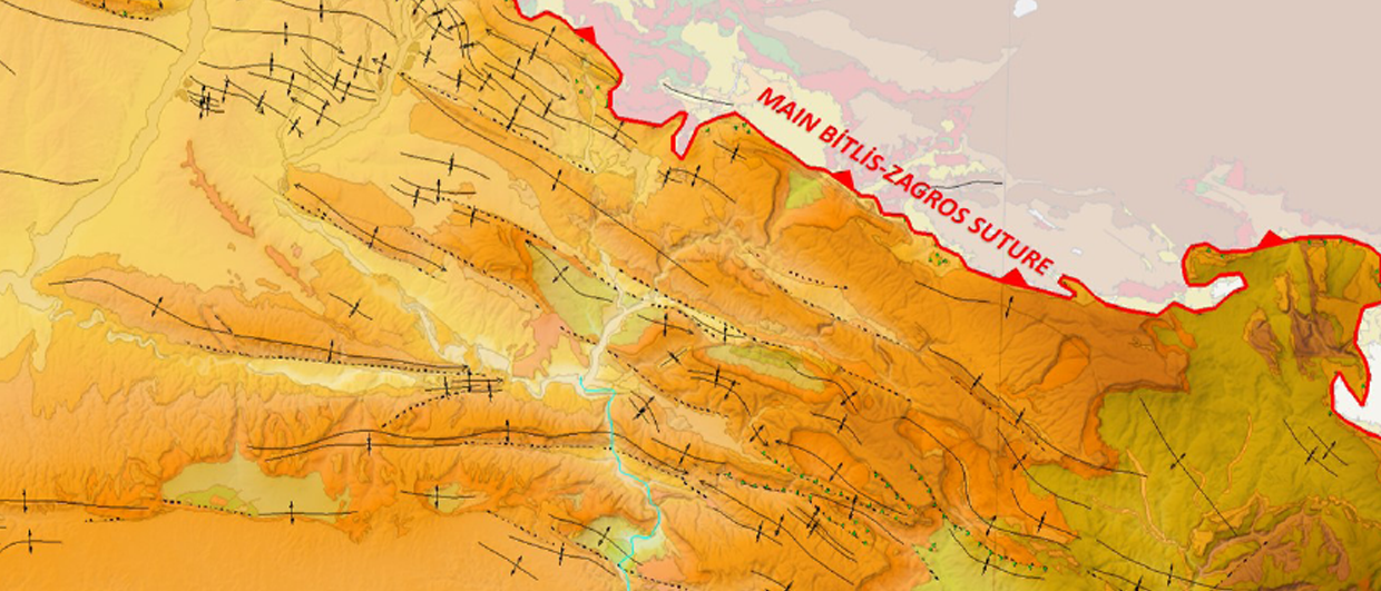
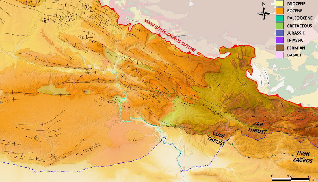
Tectonically, southeastern Türkiye is situated in the Zagros Fold and Thrust Belt. This thrust belt extends over 2,000 km in the northern part of the Arabian Platform. As the southeastern sector starts from the Oman-Hormuz Strait, the western end is represented by the junction of the East Anatolian and Dead Sea Fault Zones in Türkiye. The zone itself evolved progressively due to the closure of the Neo-Tethys Ocean between the Arabian and Eurasian Plates since the Late Campanian. Within a well-known tectonic zonation of the area, most of the prolific structures are located in the folded zone. Additionally, imbricated fault zones and allochthonous units are still under investigation.
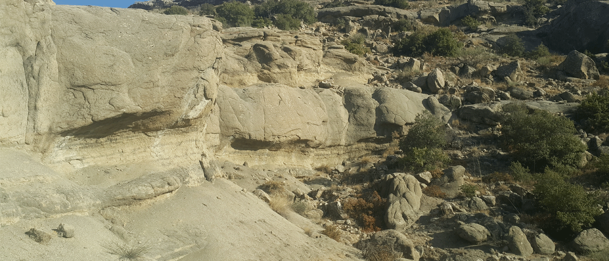
Thee folded zone of the thrust belt is characterized by prospective surface anticlines. These anticlines formed during the Bitlis-Zagros folding stage due to the continent-continent collision, commencing post-Eocene and becoming more intense during the Middle Miocene onwards.

As the surface is mostly covered by Eocene and Miocene sediments, Cretaceous carbonates are only partly exposed in the core of the anticline. They are oriented in a NW-SE or E-W direction and their axial traces show linear to curvilinear trends. “Their shape changes from symmetrical to asymmetrical geometry and dimensions reach up to four to five km in the short axis and twenty km in the long axis. They are dominantly bounded by double plunging thrusts that formed above a relatively deeper detachment surface, e.g. Triassic evaporites or older. Each anticline is separated by Upper Miocene- Pliocene filled synclines and may represent en-echelon relay geometry in areal extent.
Widespread deposition of marine carbonates throughout the Cretaceous resulted in the formation of the reservoirs belonging to the Mardin Group, which are the major reservoir targets in the basin. The depositional environment of the Mardin Group limestones ranges from inner to outer ramp. Cenomanian-Turonian age thick highstand limestones are strongly affected by dolomitization and display evidence of subaerial exposure in addition to thermal dolomitization in the subsurface. Both dolomites and limestones are highly fractured, giving a strong contribution to production performance.
An excellent source rock
During Jurassic and Cretaceous times, thick carbonate facies were deposited in passive margin settings of the Arabian Platform. During this time, sealevel fluctuations in conjunction with slow subsidence rate led to the formation of shallow intrashelf basins. Middle to Upper Jurassic organic-rich sediments of the Senoba Formation accumulated in the basin as a source rock under anoxic conditions. Organic matter of the Senoba Formation contains dominantly type-II and mixed type-II-III kerogens, showing that it is both an oil as well as a gasprone source rock. Tmax and Vitrinite Reflectance (Ro%) values demonstrate that the formation is thermally mature and located in the late mature window. As the Senoba Formation in southeastern Turkey can be classified as a good to excellent source rock, a wide spatial distribution of
oil gravities has been found, ranging from 12° to 41° API in different oil finds.
Ramping up
At the present day, daily production rate in the basin is quite low, as it stands at about 80,000 barrels per day. However, almost half of this production figure is from discoveries made in the last three years and based on the recent exploration results it is expected that production can be increased to up to two hundred thousand barrels per day in the next two years as further development plans have continued to progress.
Although the first discovery in the basin – the Raman Field – dates back to the 1940s, the recent discovery of two giant fields encourages focused exploration efforts and dedicated investments. When we revisit the question we asked above; despite the complex geology and the related uncertainty due to the highly tectonized nature of anticlines, there are still opportunities to find giant fields in southeastern Türkiye.
In addition, the existence of mostly undrilled low and high relief surface anticlines of 200 km elongation near the source kitchen are expected to be drilled in the next few years as new seismic data has become available. This could be the start of even more exploration success in near future.
Literature
Ozkan, R. And Altıner, D., 2019, The Cretaceous Mardin Group carbonates in southeast Turkey:Lithostratigraphy, foraminiferal biostratigraphy, microfacies and sequence stratigraphic evolution. Cretaceous Research, 98, 153-178.
Robertson, A., The transition from a passive margin to an Upper Cretaceous foreland basin related to ophiolite emplacement in the Oman Mountains. Geological Society of America Bulletin, v. 99, p. 633-653, 21.
U.S. Geological Survey World Energy Assessment Team, 2012, Assessment of Undiscovered Conventional Oil and Gas Resources of the Arabian Peninsula and Zagros Fold Belt.
Yılmaz, Y., Yiğitbaş, E. and Cemen, I. 2022, Tectonics of the Southeast Anatolian Orogenic Belt. ESS Open Archive. DOI: 10.1002/essoar.10510308.1