The introduction of Q-Marine* technology a few years ago has given WesternGeco a competitive edge, the company claims. In the Oslo Technology Centre they are proud of having been crucial…
Over the years remote sensing has developed from an obscure and expensive experiment to an essential and cost effective tool in the search for hydrocarbons, particularly in remote and inaccessible…
Ashton Embry, Geological Survey of Canada, Calgary
Based on recent advances in plate tectonics, sedimentology and sequence stratigraphy, I suggest that the Earth is affected by relatively short-lived episodes of increased tectonic activity separated by longer intervals…
AVO analysis provides the geologists with a powerful tool that give information about pore fluids, lithologies and reservoir pressures. However, AVO signatures can easily be misinterpreted without a proper feasibility…
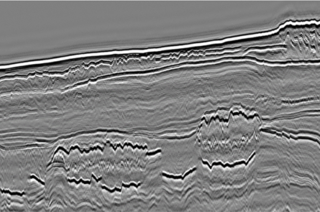
Highly permeable sand bodies injected into low permeability shales may provide additional reserves to existing discoveries and fields if properly recognized. Such sandstones, a product of postdepositional remobilisation, may also…
Reservoir modelling and reservoir simulation are based on data collected at multiple scales with resolution ranging from sub-millimetre to tens of metres. New software using knowledge of the geological processes…
The technological breakthroughs of the onwards from the early 1990s have had enormous implications for the oil and gas exploration and production industry. New methods, changing work processes and an…
A deeply buried reservoir – characterised by ultrahigh pore pressures and temperatures – represent a major challenge for both petroleum and drilling engineers. To minimise risk and maximise the collaborative…
Inconsistent methods used in the well planning process can result in erroneous decisions that have significant impact on field economics. By using a generic decision support tool, well projects can…
Reservoir rocks have much lower electrical conductivity if they are saturated with oil rather than salt water. This is the principle, well known from borehole logging, which is exploited in…
Until recently, seismic velocities have had low value spin-off value as it was only used for migrating seismic data and depth stretching from time to depth domain in workstations. The…
Tiny seismic nodes making high density land seismic accessible to all industries. Seismic acquisition has seldom seen such challenging times, especially onshore, where we are seeing tighter budgets and tougher…