Trevor Burchette, Carbonate Reservoir Geoconsulting Ltd and Royal Holloway, University of London
Up to 60% of the world’s conventional petroleum is reservoired in carbonate rocks – but they are often regarded with apprehension by the industry. Despite their reputation, carbonate reservoirs are…
The modern vibroseis is a complex, delicately tuned machine. The shaking gets translated into seismic data to provide insights into the subsurface for oil, gas and resource exploration. An 80,000…
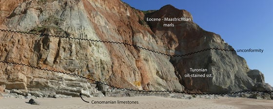
Ian Davison, Earthmoves Ltd, UK and Pedro Barreto, Partex Oil and Gas, Portugal
The discovery of an exhumed oil field in the central Lusitanian Basin in Portugal has significantly enhanced the hydrocarbon potential of Lusitanian and Peniche Basins and the conjugate Carson-Bonnition Basin…
Gehrig Schultz, Chris Tucker and Kirsty Simpson; EPI
Geophysics must change – but it must also remain meaningful. “Geophysical data are a part of everything that we do,” Stephen Greenlee, president of ExxonMobil Exploration Co., told a roomful…
Geomechanics is the study of how subsurface rocks deform or fail in response to changes of stress, pressure and temperature and it is becoming increasingly important in oil and gas…
James Lowell, Peter Szafian and Nicola Tessen; Geoteric
The key to all seismic interpretation is the interpreter’s experience and knowledge, so why should artificial intelligence change that? The reality is, it shouldn’t. Figure 1: Exmouth Basin section with…
Sven Philit, Fabien Pauget, Sebastien Lacaze; Eliis, Caroline Guion; Eliis Inc.
To boldly go where no interpreter has gone before To Boldly Go Where No Interpreter Has Gone Before The Last Frontier in Seismic Interpretation: Automatic Fault Detection The Exmouth Basin…
A Minute to Read: Following the devastating Gorkha earthquake that shook Nepal in 2015 there has been an intensification of earthquake research on and beneath Mounth Manaslu. Manaslu (8,163m), the…
Joya L. Tetreault, Carsten Elfenbein and Tomas Kjennerud; Exploro Geoservices
Why do we need a regional stratigraphical framework for the North Sea? The UK-Norway North Sea is a mature basin both in terms of petroleum exploration, data availability and geological…
Guest Contributer: Rune Tenghamn; PGS, Martin Landrø and Lasse Amundsen; NTNU and Bivrost Geo.
Part 2: Early developments of marine vibrators for geophysical acquisition techniques made by PGS. Once you know what you want in life…like a magnet you attract the resources necessary to…
Ocean-bottom seismic acquisition is encroaching on the traditional marine streamer market by offering unique, scalable and efficient solutions for exploration and development of oil and gas. A New Wave in…