
California’s Death Valley
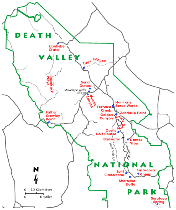 Located in southeastern California, U.S.A., Death Valley is easily reached by driving from major airports serving southern California and Nevada. Source: http://geomaps.wr.usgs.gov/parks/deva/ftmap.htmlDeath Valley National Park encompasses 14,000 km² of deserts and mountains, and is the largest outside of Alaska. The Park boasts extremes like no other. Badwater Basin, at 86 m below sea level, is the lowest point in the Western Hemisphere not covered by water. Telescope Peak in the Panamint Mountains, at 3,368 m in elevation, lies just 24 km to the west.
This vertical drop from Telescope Peak to Badwater is twice the depth of the Grand Canyon and the largest vertical drop in the contiguous 48 states. Death Valley is the hottest, with a record temperature 56.67 °C, and driest place in North America, receiving less than 50 mm of rainfall per year.
These factors give the area a forbidding image, yet for the nature or rock lover, the area offers extremes in beauty and fascinating geology.
Recent Formation of Death Valley
Death Valley is the youngest and most active portion of a Basin and Range province that covers most of the southwestern United States and northwestern Mexico. The province is characterized by the formation of steep mountain ranges separated by dry, flat valleys. The northward movement of the Pacific Plate, at about 25 mm per year, is pulling on the North American Plate where Death Valley is situated. This “stretching” of the earth’s surface is pulling apart the North American Plate, fracturing the crust and creating large normal faults and the “Basin and Range” topography. Most of the major topographical features seen today had formed by about 2 million years ago. The Death Valley area is still tectonically active as evidenced by the recent fault scarps in many of the alluvial fans.
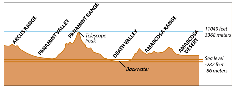
A cross sectional view of the Basin and Range topography of Death Valley National Park and surrounding areas. © USGS.
Volcanism has also played a part in Death Valley’s recent geologic history. Extension and thinning of the crust created zones of weakness, usually along faults, that allowed magma from deep within the earth to reach the surface. Aligned volcanic cones can be seen along the bases of the mountains on the west side of the valley. Many areas west of the park in the nearby eastern Sierra Nevada are still considered volcanically active.
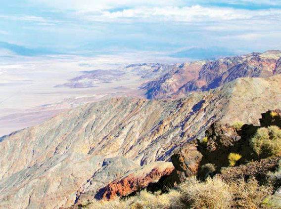
High above North America’s lowest point, salt pans, enormous alluvial fans, and spectacular geology are all seen from Dante’s View. © Tom Smith.
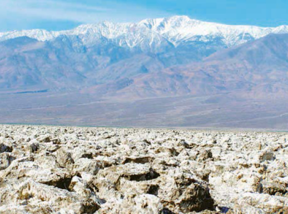
Devil’s Golf Course (foreground) is several feet above flood level. Capillary action draws moisture up into the salty crystal structures and is quickly evaporated, leaving a field of salt pinnacles. Snow covered Telescope Peak and alluvial fans are pictured in the background. © Tom Smith.
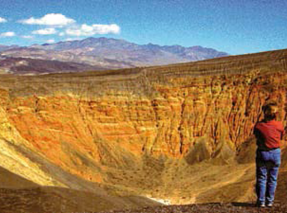
The giant Ubehebe Crater field (an Indian name meaning “Big Basket in the Rock”) attests to the violent volcanic activity associated with the faulting and stretching of the earth’s crust. The eruptions here occurred anywhere from 3,000 to 10,000 years ago. There are over 12 volcanoes in this complex, with Ubehebe being the largest and youngest. The crater itself is 234 m deep and approximately 804 m wide. These explosions stemmed from pressure building up as rising magma mixed with water saturated bedrock. Immense steam explosions created numerous volcanic craters called maars. © Tom Smith.
Wind and Water Shape the Death Valley Landscape
Water became a major factor in shaping the landscape as we see it today. During the cooler, wetter conditions of the Pleistocene ice age (186,000 to 128,000 years ago), large lakes formed in the valleys from runoff of the surrounding mountains. This led to erosion, formation of coalescing alluvial fans, and consequent lake sedimentation. Most notable of these lakes is the prehistoric Lake Manley, once a 180 m deep, 180 km long lake covering much of Death Valley. As conditions became warmer and drier, Lake Manley receded. Shoreline terraces of the ancient lake can still be seen along the flanks of the adjacent mountains.
Later, during the Holocene (2,000 to 4,000 years ago), wet conditions again prevailed and water accumulated in the valley floor. Combining with minerals left behind from earlier lake deposits, the water evaporated leaving a shallow briny lake. A salt pan is all that remains of these lakes and now covers more than 518 sq km of the valley floor.
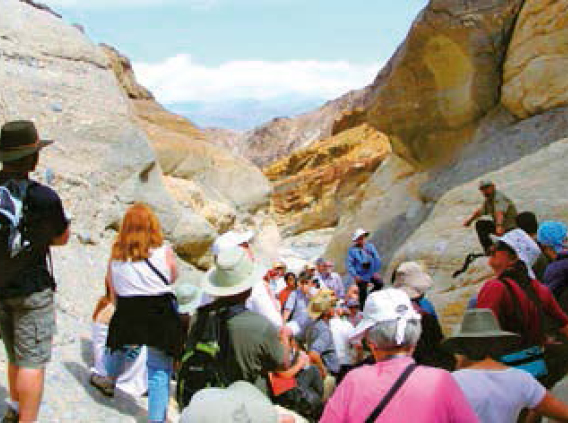
National Park Service personnel guide geological tours up the water-polished marble of Mosaic Canyon. The marble originated as limestone laid down when the Death Valley area was covered by tropical seas during the Late Precambrian, then deeply buried and metamorphosed into a “mosaic” of carbonate rocks and marble. © Tom Smith.
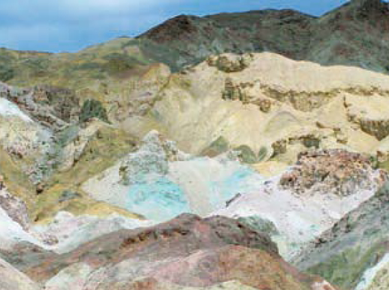
Artist’s Drive is a oneway, one lane road leading to views of the Miocene Artist Drive Formation. A thick section of cemented gravel, playa deposits and volcanic debris is exposed above the road. Chemical weathering and hydrothermal alteration have transformed these deposits into the beautiful array of colors known as Artist’s Palate. © Tom Smith.
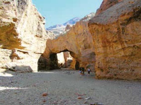
The crudely bedded, chaotic debris of an alluvial fan exposed at Natural Bridge. © Tom Smith.
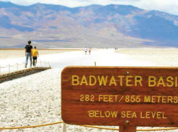
A stroll along the salt pan of Badwater will take you to an expanse of dry lake bed composed of a salt layer on top of briny mud and the lowest place in North America. © Tom Smith.
Water is also responsible for the numerous alluvial fan formations that can be seen on all sides of the valley, many with shallow channels incised on their surface. Starting high in the mountains, layers of bedrock are gradually broken into blocks. Storms create flash floods that bring these large blocks down the steep mountain sides, gradually breaking them apart. Most of the material is deposited in a chaotic manner in the form of large alluvial fans as debris filled waters slowed onto the valley floors.
Death Valley’s recently uplifted mountains expose Precambrian rocks as old as 1.8 billion years to recent deposits. These rocks give evidence of ancient seas, tropical climates, mountain building, and volcanism and are as diverse as the present day landforms.
Wind also plays its part in Death Valley. Smaller particles of silt and sand grains are picked up by the winds sweeping across the valley creating interesting deposits including sand dunes and prime examples of “desert pavement.” The wind working in two ways, both depositing and eroding, have helped form these pavements. Desert pavement consists of tightly packed stones, coated with “desert varnish.” Wind shaped rocks called ventifacts are also left with the “desert varnish”, or a wind derived dark coating of clay, iron, and manganese oxide. Many of the ventifacts display their sand blasted surfaces as pits, flutes, and grooves.
So Much More…
Death Valley is truly a land of extremes. From high temperatures, low rain fall, towering mountains and expanses of salt, everywhere you look the contrasts are unmistakable. Winter can bring snow and fierce winds; springtime can bring colorful wildflowers that cover the hills; summer sorearing temperatures; and fall as a time to reflect on this dramatic landscape.
Early explorers tried to find riches hidden in the surrounding hills. Borax was mined here and prospectors, like Walter Scott (Death Valley Scotty), exploited the mysteries of Death Valley to raise money to build his “castle”. Tours of the Spanish styled Scotty’s Castle, built in the late 1920’s and containing priceless antiques and art objects, are conducted year round.
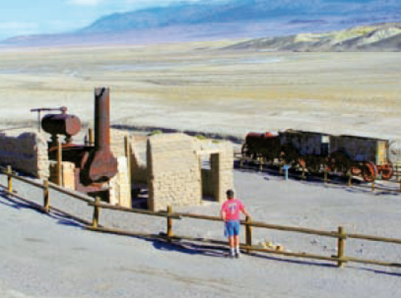
In 1881, borax was discovered in the Death Valley playa near what is now the Furnace Creek area. At that time borax was in high demand for use as an antiseptic, washing agent, and welding flux. A commercial borax mine operation, Harmony Borax Works, flourished as mule teams were used to haul the borax to market. Nearby underground springs made living in this harsh desert possible and the town of Greenland was built (later called Furnace Creek). Death Valley was “put on the map” and in 1933 was declared a National Monument, and in 1994 gained National Park status. © Tom Smith.
There are many hikes and drives available that take you through deepsided slot canyons of colorful limestones that were laid down millions of years ago when the area now known as Death Valley was covered by warm tropical seas. Other interesting sites include Salt Creek where the renowned pupfish have adapted to their very warm and saline environment.
The National Park Service Headquarters and Information Center is located at Furnace Creek, a true oasis in the desert. Here underground freshwater springs permit living in this intense climate with shady trees, visitor information and accommodations, a large swimming pool, and an 18-hole golf course where sightings of roadrunners and coyotes are not uncommon. More information on the Park and its vast areas to explore can be seen on the web at www.nps.gov/deva.


