New broadband imaging reveals prospectivity insights
New high quality seismic datasets and a regional prospectivity study bring greater understanding of the distribution and extent of resource plays throughout the Banda Arc.
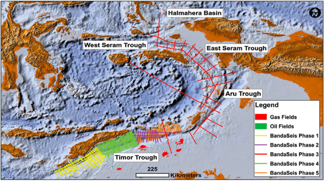
CGG acquired its BandaSeis broadband multi-client 2D dataset around the entire Banda Arc region of Eastern Indonesia using its advanced BroadSeis™ acquisition and imaging solution.
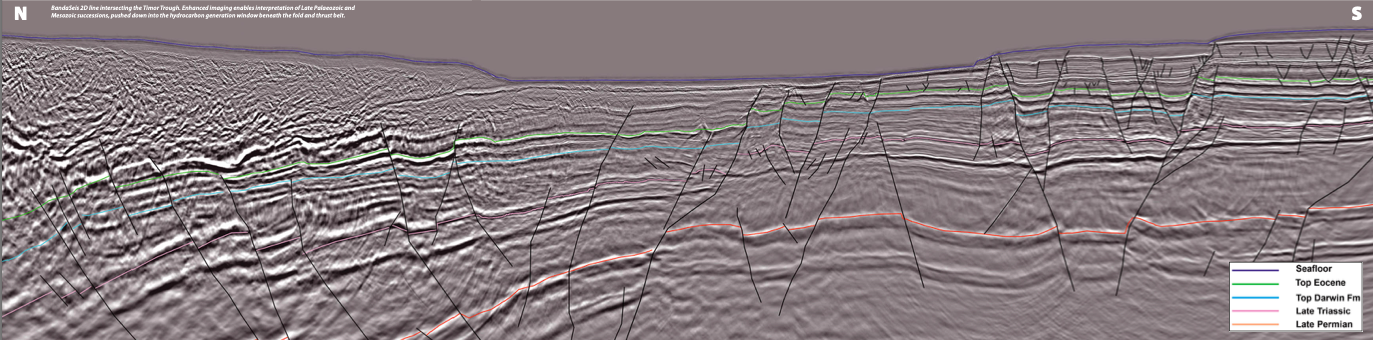
The key objectives of the programme were to provide enhanced imaging of sub-thrust successions and structuring and to better constrain the Palaeozoic and Mesozoic petroleum system elements, which are widely regarded as equivalent to the northern Bonaparte and Browse Basins of the North West Shelf of Australia. The five phases of the BandaSeis programme represent 16,409 line-km of 2D broadband seismic data, with coverage from the island of Timor in the south to Seram in the north, including a single regional line across the Weber Deep and the entire Banda Sea. The data was processed to PSDM using CGG’s advanced techniques to significantly enhance image quality, with further reprocessing undertaken in 2018 on three of the five phases of the dataset. The resulting PSDM products provided unrivalled image quality, particularly below the fold and thrust belts of the arc system.
CGG has also conducted a comprehensive regional Jumpstart™ prospectivity study leveraging new information derived from the enhanced data.
Geological overview
The Banda Arc is located within a complex convergence zone between the Eurasian, Australian and Pacific tectonic plates, resulting in intense deformation, subduction and orogeny (Hall, 2012). This highly complicated and hence poorly understood geological region represents one of the most tectonically active areas in the world.
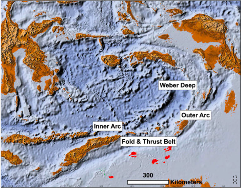
The Banda Arc exhibits a characteristic curvilinear geometry and can be divided into four main tectonic regions: an outer arc comprising a continental lithosphere and the larger islands, the major ones being Timor and Seram; an inner volcanic arc; the Weber Deep between the Inner and Outer arcs at the area of greatest curvature; and the fold-and-thrust belts that formed outboard of the Outer Arc (Baillie et al., 2014).
Eight key petroleum systems within the southern Banda Arc region can be summarised, analogously based on geological and geochemical information derived from the Bonaparte Basin (Barrett et al., 2004). They range from late Palaeozoic to late Mesozoic, including three Jurassic systems, one Triassic, three Permian, and one Permo-Carboniferous system.
Within the central Banda Arc/Tanimbar region the hydrocarbon-generative sequences are considered to be an extension of those within the Timor area, and therefore also North West Shelf equivalents. For the Tanimbar area, these petroleum systems include two Jurassic and three Palaeozoic sourced systems, equivalent to the Jurassic Echuca Shoals and Plover Formations of the Browse Basin, and the Permo-Carboniferous Milligans-Kuriyippi systems of the Bonaparte Basin.
The northern Banda Arc region, including Seram and its offshore area, hosts Lower Jurassic source rocks with potential contribution from Cretaceous, Triassic and Permian intervals.
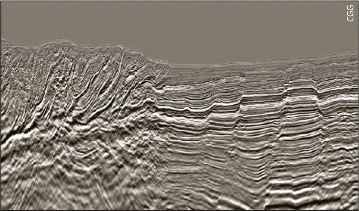
Abundant onshore and offshore seeps attest to the widespread presence of active source rocks throughout the Banda Arc, making the area of particular interest for hydrocarbon exploration. Factors influencing the limited exploration to date include remoteness and water depths. However, seismic imaging challenges, particularly beneath the fold and thrust belts, represent the key contributor to exploration uncertainty. CGG has sought to ameliorate this by providing high quality images beneath zones of significant deformation and by undertaking complementary, integrated geological interpretation and analyses to mitigate exploration risk.
BandaSeis 2D – key technologies
The BandaSeis 2D seismic programme was acquired in five successive phases over a period of three years, from 2012 to 2015. It used CGG’s proprietary BroadSeis broadband acquisition and imaging solution with 10 km maximum offset streamers. It utilises a unique variable-depth streamer profile and CGG’s proprietary broadband processing technology, including ghost wavefield elimination, to produce superior imaging results compared to conventional datasets.
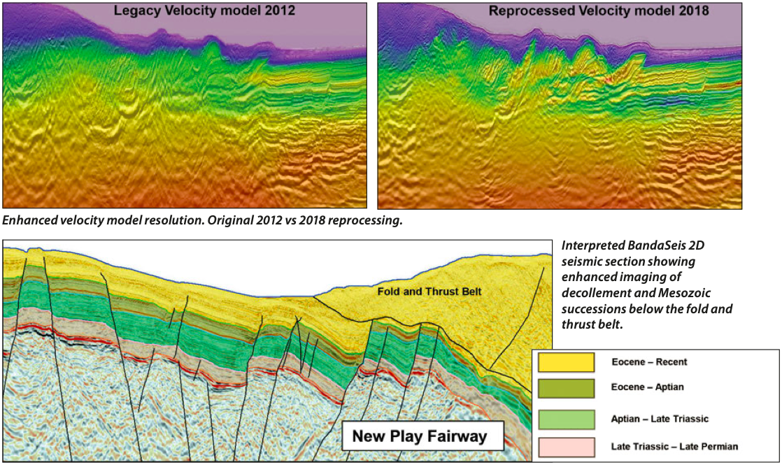
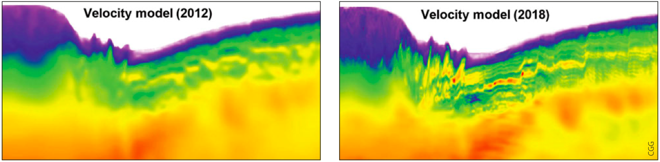
The first three phases of the data set were reprocessed by CGG utilising an updated broadband processing sequence and advanced full-waveform inversion (FWI) velocity model building to enhance visualisation of potential targets underlying highly-deformed fold and thrust belts, and to improve the low-frequency content of the data (Ping et al., 2019). High-frequency FWI (HF-FWI) was applied to the data to produce a higher-resolution velocity model with greatly improved correlation with the geology, as seen in the velocity model comparison above. The FWI technology overcomes the limitations of conventional reflection tomography in complex settings where the curvature picking and inversion are less reliable and stable.
Another key technology employed was joint source designature and deghosting, which produces a more stable wavelet phase, particularly in the low-frequency range. Application of these key technologies enhanced data quality and the ability to constrain geological features below the complex deformation zone.
Prospectivity insights from regional interpretation
Given significant knowledge gaps in the geology of the region, and a number of supporting indicators of active petroleum systems, CGG initiated a major regional study, deriving key insights from the data. The Banda Arc Jumpstart study involved an integrated methodology, leveraging the company’s extensive multidisciplinary geoscience resources. This work included new interpretation of the dataset, correlation of satellite slicks and seismic data, onshore field studies, including source rock and live oil seep sampling for geochemical analyses, integration of seismic, well and potential fields data, basin modelling, and palaeogeographic reconstructions. The new seismic interpretation, covering the entire BandaSeis dataset, was undertaken in two phases: firstly, within a regional structural and stratigraphic context; and secondly, with a detailed prospect-level interpretation. CGG also correlated the seismic interpretation with structural and potential field data analyses undertaken in parallel in a regional context.
Some key highlights from the interpretation and analyses included identification of a new Jurassic sub-basin; mapping of a Mesozoic palaeo-high that changes the understanding of deposition and thermal history; new structural insights into the whole Banda Arc tectonic evolution; and identification and evaluation of 42 new leads throughout the Banda Arc offshore areas. These key highlights, which underlie the discovery of new prospectivity insights, can be directly attributed to the ability to image beneath the fold and thrust belt, since, for the first time, geological structures can be clearly seen below more than 5,000m of orogenic wedge sediments. Most importantly, the new level of imaging quality enables a greater understanding of the distribution and extent of resource plays.
A comprehensive regional study produced to complement the dataset will enhance understanding of the palaeogeography and petroleum systems of the Banda Arc. This integrated approach to understand the total depositional systems in a geodynamic context allows for progressive de-risking of emerging plays and will underpin future exploration success in the region.
Acknowledgements
The authors wish to thank CGG Multi-Client for permission to publish this work and CGG Geoscience for their significant contribution to these results.


