
West Texas! Land of longhorn cattle, mesquite, and fiercely independent ranchers. It’s also the location of an out-of-the-way desert gem, Big Bend National Park. Wild, undeveloped, expansive vistas, and no crowds, is how the park is described. The area is rich in history. Roamed by Comanches and Apaches, settled by the Spanish, it was the Republic of Texas after 1836, and has been part of the United States since 1845. This is where many of the cattle drives that defined ‘cowboys’ began.

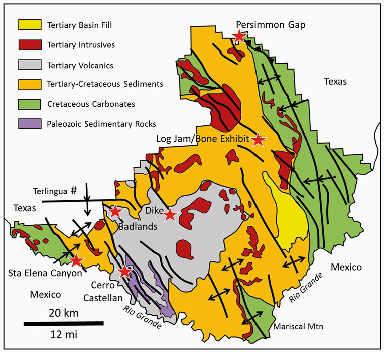
The route from Marathon to Terlingua, Texas, with stops (stars). The entire trip is 134 miles (216 km).
The region is arid, part of the Chihuahuan Desert. Mostly flat valleys are punctuated by mountains poking up through cactus and sage-strewn prairie. Summers are hot; winters are mild. Vegetation is sparse, and water is rare. None of the creeks flow all year-round.
Named for the bend in the Rio Grande, Big Bend National Park covers 324,200 hectares (1,252 square miles). This park has the variety of geologic features you would expect in an area this large (Prost, 2020).
We begin in Marathon, Texas, a thriving town of 386 souls with some of the darkest night skies in the country. We traverse the Marathon Uplift and Big Bend National Park, and end at Terlingua, a mining ghost town.
Marathon Uplift
Driving south on US-385 from Marathon, you cross a topographic basin that is a geologic uplift. The Marathon Uplift exposes Paleozoic strata of the Appalachian-Ouachita- Marathon fold and thrust belt (Variscan Orogeny in Europe). This thrust belt formed during Late Carboniferous (Pennsylvanian) to Permian time, roughly 300–270 million years ago (Ma), as the northern continent of Laurussia collided with the southern continent of Gondwana to form Pangea. Late Cambrian to Late Carboniferous sediments deposited along the southern margin of Laurussia were thrust northwest over Carboniferous deep marine units. Tectonism ended in the Permian, after which the area remained quiet until the Laramide (Rocky Mountain) Orogeny (75–40 Ma), when the older folds were refolded. The area was uplifted during the Tertiary (Hickman et al., 2009).
Big Bend National Park
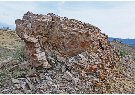
41 miles (66 km) south of Marathon you enter Big Bend Park at Persimmon Gap (29.659870,–103.173510). Big Bend Park is south of the main Ouachita- Marathon suture, on former Gondwana. Persimmon Gap lies on the ‘Comanche Trail’, a path used by Native Americans to move across Big Bend country. The gap is named after native Persimmon trees that thrive in the area.

Laramide thrusting seen from Persimmon Gap. Lower Cretaceous Glen Rose Formation is thrust over the Upper Cretaceous Aguja Formation.
This low pass in the Santiago Mountains exposes a southwest-directed Laramide-age thrust. Late Cretaceous to Eocene Laramide deformation in North America is related to subduction along the west coast and is characterized by east-northeast shortening.
Rifting opened the Gulf of Mexico, beginning in the Late Triassic. This area was then covered by a shallow sea until Late Cretaceous time and a thick limestone section accumulated on a carbonate platform. As the sea began to retreat, around 100 Ma, sandstone and shale were deposited in shallow marine and shoreline environments. Remnants of these sediments form flat to gently inclined strata throughout the park and contain fossil oysters, clams, ammonites, and a variety of fish and marine reptiles.
Simplified geology of Big Bend National Park. Modified after Gray and Page, 2008.
Laramide shortening caused northwest-southeast oriented features such as Sierra de Santa Elena/Mesa de Anguila in the southwest corner of the park. Mariscal Mountain, 16 miles (26 km) south of the Panther Junction Visitor Center, is the southernmost uplift of the Rocky Mountains.
Overlapping the Laramide Orogeny was a period of volcanism. Lava flows, dikes, sills, laccoliths (domed sediments over intrusions), and ash eruptions occurred between 46.5 and 28 Ma. These features formed the Chisos Mountains and are present in Big Bend Ranch State Park to the west.
Basin-and-Range extension began around 25 Ma and is ongoing. This orogeny created normal fault-bounded mountains and valleys. The Terlingua Fault bounding the Mesa de Anguila has about 6,000 ft (1,830m) of vertical offset. The area is presently being uplifted around 3 inches (8 cm) per 100 years.
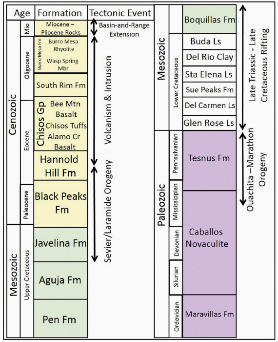
Stratigraphy of Big Bend National Park. Modified after Gray and Page, 2008.
Today, erosion cuts away at the mountains and fills the intervening valleys. Only in the last 2 Ma has the Rio Grande reached these valleys and connected them to the Gulf of Mexico, making it the youngest major river in the United States.
Fossil Trees/Logjam
Follow the Main Park Road 17.7 miles (28.5 km) south from Persimmon Gap to the unmarked Fossil Trees/Logjam site (29.431413,–103.136839). Between 400–500 ft (120–150m) east of the road on a low rise is a river channel sandstone in the Paleocene Black Peaks Formation. This bed contains abundant petrified logs, some up to 30 ft (9m) long. All are Paraphyllanthoxylon abbotti, a Cretaceous-Paleocene broad-leaf tree.
Fossil Bone Exhibit
Continuing south on the Main Park Road for 1 mile (1.6 km) brings us to the Fossil Bone Exhibit (29.418922,–103.138278). The Exhibit Ridge Sandstone member of the Eocene Hannold Hill Formation is a conglomeratic river sandstone filled with fossil bones. The Late Cretaceous Javelina Formation in this area consists of alternating lacustrine shales and stream channel sandstones. The upper part of the sandstonecapped ridges contain sauropod (Alamosaurus sanjuanensis) and pterodactyl (Quetzalcoatlus northropi) bones. This giant flying reptile had wingspan over 10m (35 ft).
Volcanic Dike
Continue south on Main Park Road to Ross Maxwell Scenic Drive and turn south. At 25.2 miles (40.5 km) from the Bone Exhibit a pullout on the east side of the road has an interpretive plaque. The ‘Volcanic Dike’ (29.2676,–103.3687) forms a wall across the landscape. This Oligocene rhyolite dike was intruded into the Chisos Formation volcanics (Turner et al., 2011).
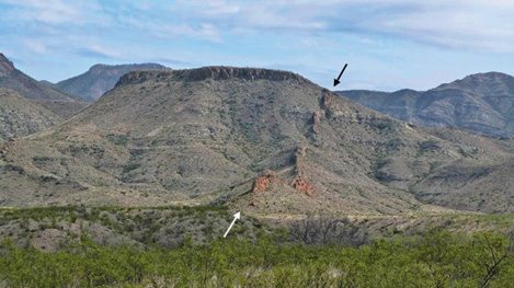
The ‘volcanic dike’ in the Chisos Volcanics.
Cerro Castellan
Continue south on Ross Maxwell Scenic Drive for 17 miles (27.4 km) to Cerro Castellan (29.1486795,–103.5030757). A resistant lava flow caps this monolith. The base is the Eocene-Oligocene Chisos Group tuff, which is overlain by the Bee Mountain basalt, then more Chisos tuff. Oligocene Burro Mesa rhyolite tops the peak (Gray and Page, 2008).
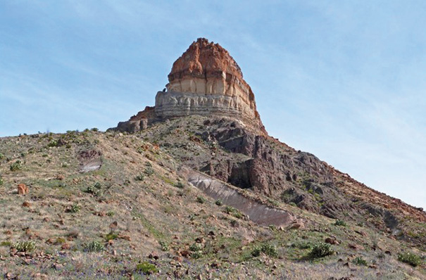
Cerro Castellan consists of a resistant lava flow over volcanic tuff.
Santa Elena Canyon
Continue driving 9.7 miles (15.6 km) west on Ross Maxwell Scenic Drive to Santa Elena Canyon (29.167368,–103.610305). This is arguably the most spectacular location in the park. Santa Elena Canyon is a dramatic gorge cut by the Rio Grande through the Mesa de Anguila. This northwest-southeast uplift is tilted southwest and has a towering, east-facing escarpment along the Terlingua Fault. Lower Cretaceous strata exposed in the canyon include, from top down, Santa Elena Limestone (upper cliffs), Sue Peaks Formation (slope-former), Del Carmen Limestone (lower cliff), Telephone Canyon Formation, and Glen Rose Limestone (lower slopes and ledges). A short nature trail enters the chasm from the east. At the canyon entrance the walls rise 460m (1,500 ft) above the river and a prominent rudist layer outcrops in the Del Carmen Limestone near the canyon mouth. Santa Elena Canyon is an ‘antecedent river’, cut downward by a combination of abrasion and chemical solution of the limestones. The Rio Grande has been grinding downward at a rate of 0.0008 inches per year (0.25 mm per year) for the last 2 Ma.
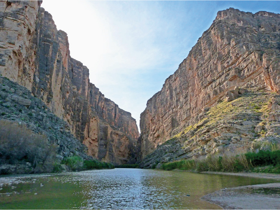
Santa Elena Canyon and the Rio Grande looking west.
Volcanic Badlands
Return east to Old Maverick Road and turn north; drive north for a total of 10.9 miles (17.6 km) and pull over (29.2703626,–103.5224992). The valley fill here contains mostly Pleistocene volcanic material eroded off the Chisos Mountains to the east. The road crosses a ‘pediment’, a low-relief, gently sloping erosion surface, and ‘bajadas’ of coalescing alluvial fans. These colorful sediments are easily eroded and transformed into the rugged terrain known as Badlands.

Looking east from Old Maverick Road to the volcanic Badlands.
Terlingua
Continue driving northeast on Old Maverick Road to the junction with TX-118; turn west onto TX-118 and drive to FM-170 in Study Butte; turn west on FM-170 and drive to Terlingua (29.320722,–103.617276), a total of 11.6 miles (18.7 km). We end this transect in Terlingua, an old west ghost town that is seeing something of a revival (110 inhabitants in 2019). Terlingua was the main source of mercury in the United States during World War I. The deposits were depleted and the mines were abandoned by 1946. Since 1967 the ghost town has become world-famous for their annual chili cook-off that attracts as many as 10,000 visitors the first Saturday of each November.
References
Gray, J.E. and Page, P.R. 2008. Geological, Geochemical, and Geophysical Studies by the U.S. Geological Survey in Big Bend National Park, Texas. Circular 1327, p. 104.
Hickman, R.G., Varga, R.J. and Altany, R.M. 2009. Structural style of the Marathon Thrust Belt, West Texas. Journal of Structural Geology 31, pp.900–909.
Prost, G.L. 2020. North America’s Natural Wonders: Appalachians, Colorado Rockies, Austin-Big Bend Country, Sierra Madre. Geologic Tours of the World. CRC Press, Boca Raton, London, New York. p. 375.
Redfern, F. 2006–2018. Virtual Geologic Field Trips to Big Bend National Park. http://prism-redfern. org/bbvirtualtrip/elena/elena.html. Accessed May 7, 2019.
Turner, K.J., Berry, M.E., Page, W.R., Lehman, T.M., Bohannon, R.G., Scott, R.B., Miggins, D.P., Budahn, J.R., Cooper, R.W., Drenth, B.J., Anderson, E.D. and Williams, V.S. 2011. Big Bend National Park, Texas. U.S. Geological Survey Map SI-3142, 1:75,000.


