Oil exploration moved from the land to the sea only a few years after Titusville. Here we take a look at how offshore oil exploration in the Gulf of Mexico developed from 1869 to the early 1960s.
In the days before underwater probes and 3D imaging, the oil pioneer had to visualize how the oil-rich rock formations of the land extended under the sea. As E.W. Owen’s Trek of the Oil Finders observed, “no evidence suggested that the present shoreline constituted the boundary of a separate structural province”. But as the search for submarine oil in the United States moved from an exploration of its lakes and marshlands to its shorelines and shallow marine waters, and then beyond sight of land, so the risks increased accordingly – the sheltered bays and creeks of the coast were relatively benign when compared with the perils of open water.
Early Pioneers
Rowlands’ 1869 patent for a ‘submarine oil drill’. (Source: United States Patent and Trademark Office)
In 1869, only ten years after Col. Edwin Drake first struck oil at Titusville, Pennsylvania, Thomas Rowlands took oil well design a step further by adapting it for use at sea, obtaining a patent for what he called a ‘submarine oil drill’. The rig was designed for drilling in shallow water, and its appearance – with four telescopic legs resting on the seabed – resembled a modern jack-up rig. Bearing in mind that offshore drilling would not become a serious commercial activity for many years to come, Rowlands’ invention was remarkable indeed.
In 1891, following the discovery of oil in the Trenton limestone reservoirs, oilmen reached Grand Lake St. Marys, a shallow man-made lake in Ohio known locally as the Reservoir. A decision was made to drill on the lake but, while drilling wells on land was familiar practice, techniques for drilling in water were as yet unproven. In the event, pilings were driven into the bedrock under the lake to create ‘cribs’ on which cable-tool rigs were mounted.
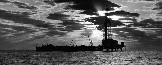
But it was in California that marine drilling truly began. In 1896 Henry L. Williams and his associates, having drilled three wells on the shore at Summerland, built a pier 90m out into the Pacific and placed a cable-tool rig on the end of it. There followed 400 wells, and the offshore field continued to produce oil for the next 25 years.
Oil wells in the ocean and on the shore, California, 1947. (Source: Library of Congress)
The system of piers, or trestles, first used at Summerfield, was still in evidence in the 1940s. In Baku, for example, extensive trestle systems were employed to extend drilling into the Caspian Sea. Elsewhere, there were many variations.
On Lake Maracaibo in Venezuela, where oil had been apparent to Europeans since Spanish sailors arrived in the 16th century, attempts to use wooden structures as drilling platforms had been abandoned after marine termites bored into them, even when they were coated with creosote. They were replaced by concrete pilings, leading the operator, Creole Petroleum, to construct 106 drilling platforms on the lake.
Drilling on Lake Caddo, on the border between Louisiana and Texas, had resulted in a spread of activity across the wetlands and bayous of Louisiana, with numerous refinements such as platforms made of oyster shells, sunken barges and timber-plank roads built over the water. However, the Great Depression of 1929 brought a worldwide slump and a decline in exploration.
Wind, Waves and Weather
The Gulf of Mexico was an intriguing prospect. For years, the Texas and Louisiana coastlands had yielded rich pickings for oil prospectors: its situation on the continental margin provided near-perfect conditions for the laying down of oil-rich sediments over millions of years, and its salt plugs and anticlines provided ideal hydrocarbon traps. In 1938, an American company, Humble Oil, had built into the sea a mile-long wooden trestle with railway tracks and ending with a derrick, at McFadden Beach on the Gulf of Mexico, but in August 1938 a hurricane severely damaged the pier and drilling platform. The company bowed to the inevitable and abandoned the costly operation without finding commercial oil.
The Gulf of Mexico, in perspective view, with countries and major cities. (Source: NOAA)
Meanwhile, in 1937 two independent firms, Superior Oil of California and Pure Oil, had built a large platform 2 km from the shore at a depth of 4m. With 300 piles of yellow pine driven into the seabed, it was designed to withstand hurricane-force winds. The platform was built 4.5m above the sea so that if very high waves should impact the rig, the platform would detach from the pilings, thus avoiding the loss of the whole structure. In fact, this happened in 1940 when a hurricane swept the deck and damaged piles, but workers were soon able to rebuild it. The fact that this, the Creole field, was successful vindicated the risk of the venture, but the disadvantages of having such large, fixed platforms remained. They were costly to build and, if the well proved dry, those costs were not recovered.
And yet the high cost of drilling at sea encouraged innovation, resulting in a number of new techniques that transformed offshore drilling. Drilling narrower (‘slim’) exploratory holes brought a switch from steam to diesel-electric rigs; and rather than drilling single wells vertically from a central platform, oil companies such as Pure and Superior embarked on directional drilling, which enabled several wells to be drilled from a single platform. A novel procedure at the time, it would become an industry standard in future years.
Kerr-McGee Oil Industries and Humble adopted a different approach, building smaller platforms which housed the drilling equipment, with the living quarters located on tenders – ex-World War II landing craft with their engines removed. If a well came in dry, the tender could simply be towed to another site, thus reducing the cost of each well. This configuration did bring its own problems, however. It was difficult for workers to climb onto the platform in rough weather – so much so that the bridge they crossed was christened the ‘widow maker’. Shrimp-boat captains were often hired to bring crews from the shore only to find that the sea state was too rough to allow them to board the platform or the tender alongside. Even locating these platforms at sea could be challenging in adverse weather conditions without the benefit of modern navigational aids. And in harsh weather the tenders could break loose from their moorings and, having no engines, smash into the platforms.
Through a process of design and experiment, trial and error, the challenges of open water were largely overcome. Hurricanes remained a constant seasonal threat in the Gulf of Mexico, but structures were getting stronger. Lack of knowledge about weather was being remedied by a growing number of navigational aids and weather forecasting systems. The US Pioneers Corps had specialized in wind, tides and other weather forecasting for the seaborne landings of World War II, and this knowledge was transferred to the offshore oil industry in peacetime. The American Petroleum Institute also started collating information, giving the operators of marine rigs more tools to predict the weather and evacuate the rigs in the event of an impending storm.
Map of the northern Gulf of Mexico in 2012 showing almost 4,000 active oil and gas platforms. (Source: NOAA)
The Application of Science
Meanwhile, there were new developments on land. First magnetic surveys, then gravity and electrical methods were used to map the subsurface – but it was the advent of seismic techniques that transformed oil prospecting, both on land and sea. In 1938 Shell Oil started experimenting with seismic testing off the Louisiana coast, where a ‘shooting’ boat would drop a single stick of dynamite into the sea and measure the seismic waves with geophones on the seabed. Six years later, Superior Oil and Mobil followed their example in order to look for salt domes using much the same arrangements. Kerr-McGee used shooting boats that would circle the recording boat, setting off charges at regular intervals. By 1947, all the equipment – shooting and recording – was housed on a single boat.
After World War II, many of the independent oil companies that had been excluded from land-based exploration by leases granted to the oil majors took advantage of the new technology to extend their operations offshore in the Gulf of Mexico. The problem of drilling at depth remained. A number of different designs were tried: submerging a floating barge at the site to provide a base for a drilling rig, with a platform above the surface; small, fixed platforms without living quarters; and larger submersible platforms.
The new seismic techniques revealed many salt domes in the Gulf, prime objects for further investigation. Creeping towards deeper water continued. In 1946, Magnolia Petroleum demonstrated that it was possible to drill beyond the three nautical miles (5.5 km) of territorial waters. In October 1947, another milestone was reached when Kerr-McGee drilled the first discovery well out of sight of land, a fixed platform at a water depth of 5.5m, some 16 km from the shore. By 1948, 24 operations were taking place beyond the three-mile limit and, a year later, a mobile offshore rig was launched. In 1954 the first jack-up rig arrived – in time, this type of rig would be able to drill in water 90m deep.
A Shell Oil seismic vessel in the Gulf of Mexico, April 1951. (Source: DeGolyer Library, SMU)
Workers guiding the bottom hole assembly with stabilizer and new rock drill bit on an offshore drilling platform, 1955. (Source: DeGolyer Library, SMU)
A De Long jack-up rig at Orange, Texas, February 1955. (Source: DeGolyer Library, SMU)
Ocean America, a semi-submersible drilling rig in the Gulf of Mexico, 1998. (Source: BP Archive)
Into Deeper Water
In 1945, after shortages of oil during the war, the US Congress investigated petroleum resources. On 28 September, President Truman proclaimed the United States’ right to exploit its continental shelf, extending its jurisdiction well beyond the traditional three-mile territorial limit. He stated that the United States regarded as part of its jurisdiction the natural resources of the subsoil and seabed of its entire continental shelf (defined as the area up to a water depth of 180m).
In the Tidelands controversy, a series of legal proceedings arising from a dispute between the United States and Texas, the limits of state and federal ownership over the three-mile wide marginal sea was established. In 1953 the Submerged Lands Act was passed, recognizing state ownership of the minerals and resources of the marginal sea to their historic boundaries, with the remainder owned by the federal government. Legal challenges followed over many years, the last being settled in 1963.
Today, offshore oil is a worldwide industry exploring to ever-increasing depths. The real breakthrough came in 1962 with Shell’s semi-submersible rig, Blue Water 1, which was the first rig to be detached from the seabed, relying on a mooring system of eight anchors to keep it steady in the water. This, together with remote wellhead assembly on the sea floor, opened up the possibility of drilling and maintaining wells in deepwater. At present in the Gulf of Mexico there are 15 structures operating in water depths greater than 304m. In 2005, the Discoverer Spirit drillship drilled the Stones-2 well to a true vertical depth of 8,705m in a water depth of 2,919m, an achievement that would have surely amazed the early offshore pioneers.


