
Greater Castberg Survey – A catalyst for further development
Advanced imaging of New TopSeis data addresses challenges in this complex area and provides crucial new insight in the hunt for additional hydrocarbon resources in the Barents Sea.
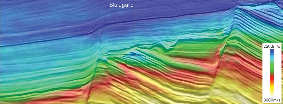
Exploration activity in the Barents Sea has fluctuated considerably over the last 40 years, in line with the price of oil and general industry optimism. Today’s high level of activity focused on ongoing and planned field developments and production may spur further exploration as infrastructure is developed. Exploration efforts in the vicinity of the producing Snøhvit and Goliat fields have been successful, and the ongoing development of the Johan Castberg field is opening up new areas for near-field exploration. An important tool in the search for additional resources is the recently processed Greater Castberg seismic survey, a CGG/TGS multi-client joint project. The survey was acquired with TopSeis™ technology, developed by CGG in collaboration with Lundin Energy Norway, which deploys wide-towed sources on top of the streamer spread in combination with a large front source (see Vinje et al., 2020). CGG processed the data, leveraging its unique experience of imaging TopSeis data and applying tailored proprietary high-end processing and imaging technologies, to deliver exceptional high-resolution depth-migrated seismic, a very detailed velocity model (see Figure 1) and high quality AVO information (Salaun et al., 2020).
Exploration history in the Great Castberg Area, Barents Sea
The main hydrocarbon discoveries in the Greater Castberg area have been made in the Early to Middle Jurassic Stø, Nordmela and Tubåen formations. Significant resources are also confirmed within the Early Cretaceous Knurr and Kolmule formations.
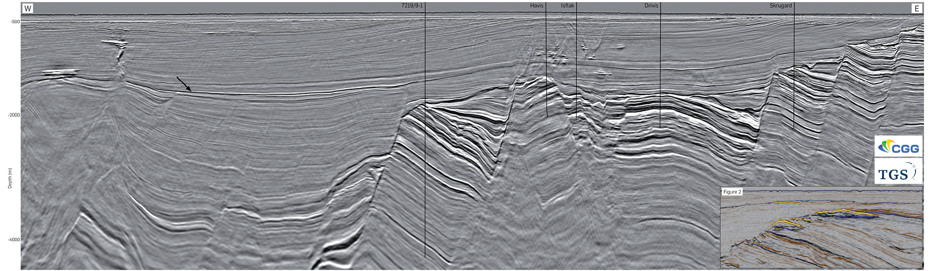
Key wells in the exploration history of the Greater Castberg area are shown in the foldout seismic image. Norsk Hydro drilled the first well in the area in 1988 (7219/9–1), targeting a Jurassic rotated fault block, but unfortunately the well was dry. It was not until 2011 when Statoil drilled the Skrugard prospect (7220/8–1) that fortunes changed. The discovery is located on a rotated fault block where gas and oil were proven in Early to Middle Jurassic Stø and Nordmela sandstones. Skrugard opened up a new hydrocarbon province and was subsequently followed by a number of additional successful wells. Skrugard and the other two main discoveries, Havis and Drivis, are now being developed in the Johan Castberg field and are expected to hold 450–650 MMbbl of oil. The latest discovery, Isflak (7220/7–4), was made this year. Estimated to hold 31–50 MMbbl of recoverable oil it may be included in the field development at a later stage.
Hydrocarbon discoveries made outside the actual survey area are also relevant when evaluating the prospectivity of the Greater Castberg area. In the southern part of the Loppa High, the Gotha (7120/1–3) and Alta (7220/11–1) discoveries demonstrate reservoirs within Carboniferous to Permian carbonates and Permo-Triassic conglomerates in structural closures.
On the Loppa High in the east, the Neiden discovery (7220/6–2) proved oil and gas within carbonates of the Permian Ørn Formation.
In the Bjørnøya Basin, north of the survey, the Pingvin discovery (7319/12–1) proved gas stratigraphically trapped in a sandstone reservoir of the Paleocene Torsk Formation.
Prospectivity in the Greater Castberg Area
Within the survey area, erosion features and internal structuring can be seen within the paleo-Loppa basement ridge (Selis Ridge), indicating weathering that may have resulted in secondary porosity and possible productive reservoir properties (see Vinje et al., 2020). An appraisal well (7220/11–2) drilled at the Alta discovery indicates residual oil encountered in the basement. The weathered basement may potentially contribute with additional reservoir volumes if a discovery is made in the overlaying units.
Dissolution and karstification of Carboniferous to Permian carbonates can be seen over the Loppa High, due to sub-aerial erosion during the Middle Permian. These features allow for improved reservoir properties within the carbonates, as seen in the Alta and Gotha discoveries.
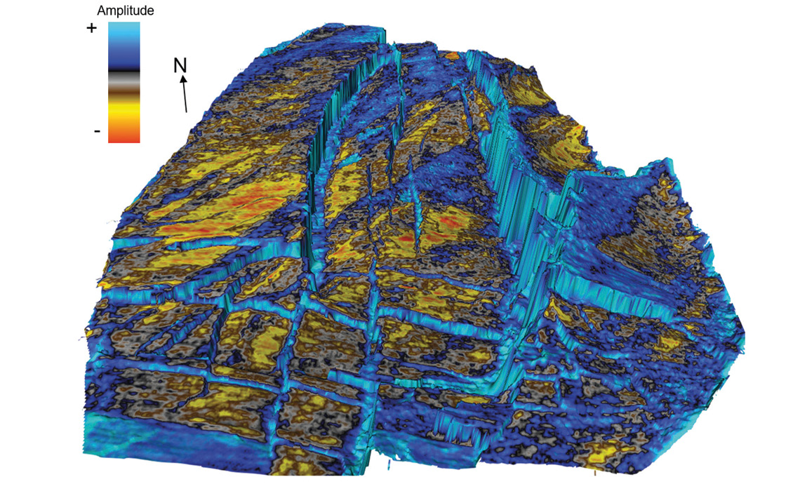
On the Loppa High and the Polheim Sub-platform the Triassic is represented by the Snadd Formation with the Carnian sands deposited in fluvial channels or possibly in a coastal/nearshore environment. Figure 3 shows a number of bright anomalies that can be identified within open acreage on the Polheim Sub-platform. Interpretation of these potential sands benefits from the densely sampled high-resolution TopSeis data, allowing better prediction of reservoir quality and hydrocarbon presence.
In the Bjørnøyrenna Fault complex the high-resolution TopSeis data reveals untested leads that may bring additional resources to the Johan Castberg field in the future. Foldout figure 2 shows two bright spots on full-stack amplitude data that are located within Middle Jurassic and Lower Cretaceous strata with flat events underneath (direct hydrocarbon indicators).
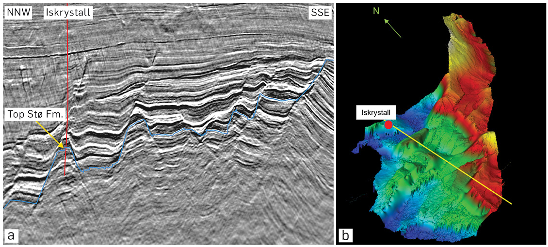
Other leads are observed in rotated fault blocks located in open acreage east of the Iskrystall well (7219/8–2), with reservoir potential within the Early to Middle Jurassic sediments. The Iskrystall well encountered 132m of gas-filled sands but reservoir quality was limited due to quartz cementation. In Figure 4, a number of tilted fault-blocks can be seen up-dip from the well where the Jurassic targets may contain better reservoir properties and merit further investigation.
The Kayak (7219/9–2) and Nunatak (7220/5–2) wells represent significant discoveries within Early Cretaceous Kolmule and Knurr formations. The foldout image shows high-amplitude reflections in the Cretaceous strata, truncated by the Base Cenozoic unconformity (black arrow on foldout line) and with seismic indications of gas leakage above the truncations. The features are located in open acreage in the western part of the Bjørnøyrenna Fault Complex and interpreted as Early Cretaceous sand deposits possibly holding hydrocarbons.
In the Bjørnøya Basin the Pingvin discovery encountered 30m of gas within a Paleocene submarine fan reservoir with the most likely provenance of the reservoir sands from the north/north-west (Blaich et al., 2017). Within the TopSeis dataset, high-amplitude features near the base of the Cenozoic can be seen in what have been interpreted as similar sand deposits in locations further south into the basin.
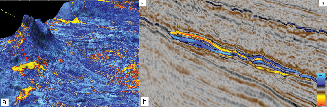
A particular feature is observed on the flank of a salt diapir (Figure 5). The top reflector shows a polarity change from the lower part of the feature to the upper part and the soft event (red, negative) brightens considerably on the far-offset stacks and the shallow anomalies above the feature indicate gas leakage. The bright anomaly is interpreted as a sand-rich fan deposit with possible hydrocarbons, analogous to the Pingvin discovery.
Future plans
Looking forward, there is potential for further increased activity in the Barents Sea in the years to come. A Plan for Development and Operation (PDO) is expected for the Wisting Field in late 2022 and Lundin is still evaluating commercialisation of the Alta and Gotha discoveries. Lundin and partners in license PL1083 are investing heavily in the Nordkapp Basin by acquiring an advanced survey combining TopSeis technology and ocean-bottom nodes. In the 25th licensing round new acreage was awarded north of the Wisting Field. We therefore expect near-field, infrastructure-led exploration to play an important part in the search for new resources and believe that the imaging challenges in the Barents Sea require tailor-made technology solutions. In the Greater Castberg area the new TopSeis imaging results look set to be a catalyst for further development, providing the best data quality for revealing the remaining prospectivity.
All images courtesy of CGG Multi-Client and TGS.
References
Salaun, N., Reinier, M., Henin, G., Gigou, G. and Wright, A. (2020). Capturing the value of source-over-streamer acquisition for velocity model building at Barents Sea. EAGE Conference and Exhibition.
Blaich, O. A., Tsikalas, F. and Faleide, J. I. (2017). New insights into the tectono-stratigraphic evolution of the southern Stappen High and its transition to Bjørnøya Basin, SW Barents Sea. Marine and Petroleum Geology 85 (2017) 89-105.


