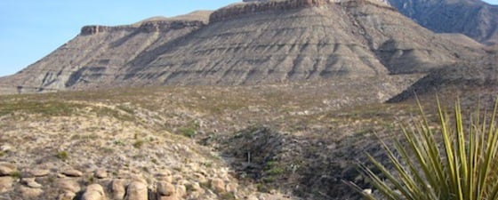
No other place on earth offers a better opportunity to study a complete depositional system from outcrop to the subsurface than the Permian Basin region. The Guadalupe and Delaware mountains provide excellent outcrop control with very little structural deformation. These mountains are cut by canyons at nearly right angles to depositional strike, exposing natural cross sections through each of the sedimentary environments. In addition to the excellent outcrops, the same formations are present in the subsurface in the adjacent oil- and gas-producing regions to the south-east and have been penetrated by tens of thousands of wells.
This Permian carbonate system can literally be walked from shelf-interior, back-reef, across the reef at the shelf margin and down the fore-reef slope into the deep basin. (Please note: take plenty of water and several pairs of sturdy boots!) In all practicality, the geotourist can observe the entire depositional facies along US Highways 62 and 180, into McKettrick Canyon in the Guadalupe Mountains National Park, continue up Walnut Canyon to Carlsbad Caverns Visitors Center, and finally follow along Dark Canyon to Sitting Bull Falls and Rocky Arroyo. According to an online field guide by Dr. Peter Scholle and others (An Introduction and Virtual Geologic Field Trip to the Permian Reef Complex, Guadalupe and Delaware Mountains, New Mexico- West Texas), to visit most of the important outcrops, road log miles exceed 240 (386 km) plus a difficult hike up McKettrick Canyon that takes about 5 hours.

Source: NPS

Behind the Reef Front
 Calcareous sponges in growth position form much of the reef’s framework, often coated by red algae. The dark material is early marine cement. Source: Thomas SmithNow let us start our journey across this ancient depositional system. We begin in the furthest shelfward units that were deposited on a broad, sabkha-type plain. Clastic terrigenous detrital material was brought in primarily from the north, some by ephemeral streams but most of the material arrived by aeolian processes. Today, we see massive redbeds and thin sandstone interbeds that show few sedimentary structures. Beds of gypsum, commonly with nodular fabrics, are interstratified with the terrigenous deposits.
In the Permian, we would be standing on an evaporitic plain over which large dunes have migrated; the only sediments trapped here would be those held by a capillary fringe that exists above the water table.
As we ease slightly seaward (to the east), fine-grained and thin-bedded dolomicrites become interbedded with the redbeds and evaporities. Little in the setting has changed; we are still in a shallow sub-tidal or lacustrine environment on a hypersaline lagoon. On outcrop, these strata have considerable moldic and fenestral porosity but in the subsurface the equivalent units are completely plugged with evaporate minerals, particularly anhydrite.
A bit closer to the shelf edge, we encounter a pisolite facies that is over a kilometer wide and lasted through nearly a kilometer of sedimentary buildup. This zone consists primarily of pisoids that can be over 5 cm in diameter. The beds are commonly reversely graded, with finer pisoids at the base. Some marine fossils can be found in this facies becoming more abundant heading seaward. Like the other facies in this environment, outcrop porosities can be quite good but nearly entirely filled by evaporate minerals in the subsurface.
Interpretation of the depositional environment suggests a similarity with some of the coastal lakes and sabkhas of southern and western Australia. Researchers have found many similar features to those found along the Permian shelf, including aragonitic tepee-pisolite beds. These beds are formed from seep-springs that are found in the transition zone between the more open marine environments and the evaporitic lagoonal environments that lie landward of this transition zone.
The Shelf Margin
 A large block of fore-reef material that has been transported onto the very fine-grained basinal deposits. Some deposits that contain such blocks have been mapped out into the basin as much as 10 km from the base of the slope. Source: Thomas SmithSeaward of the pisolite zone, we are now walking along a variety of lithologic units that were deposited in open marine conditions. Life is abundant here and marine fossils such as fusulinids and other foraminiferas, algaes, pelecypods, and other skeletal grains make up a large part of the grainstones and packstones seen in outcrop. These units generally shallow upward from subtidal to supratidal which occurs on a small scale (over centimeters) to very large shallowing units that are 30 or more meters thick.
If we were to view this first depositional area seaward of the pisolite zone, we would see an area of small sand waves and islands with tidal cuts and passes between the islands. The landward side of this zone would be seen as nearly continuous barrier islands. These shifting islands kept the open marine waters from moving farther inland. Porosities vary in this zone as widely as the facies. Massive marine cements can block all porosity but on the more landward portions, leaching of unstable grains has aided the development of very good moldic porosities. In the subsurface, this island belt has undergone only partial dolomite replacement and has only minor pore-filling evaporates. Being capped by evaporate seals, these rocks are prolific reservoirs.
Venturing just seaward of these islands, we are at the reef. Similar to today’s reefs, the Capitan reef contains the most diverse fauna and is the primary carbonate factory for the depositional system. Common to this reef complex are calcareous sponges and bryozoans which form much of its framework, with phylloid algae forming a subsidiary framework. Other organisms include crinoids, echinoids, brachiopods, gastropods, ostracods, corals, trilobites, and cryptic sponges.
The facies sequences found here are very similar to those found across Caribbean reefs. The primary difference is that the calcareous sponges are now replaced by a variety of corals and the Permian green algae Mizzia or Macroporella has been replaced by Halimeda.
Penecontemporaneous marine cementation rapidly filled any cavities in the reef along the shelf margin. These early aragonitic and calcite cements were a major factor in the rock formation but also have reduced the porosity so that the reef facies is not an important hydrocarbon reservoir.
The Capitan reef grew quite quickly, generating more material than could be accommodated. Some of the excess material was deposited onto the back-reef but most onto the fore-reef and down slope into a 600m deep basin. Consequently, the reef prograded seaward nearly 10 km over its 5 million year life.
Beyond the Shelf Margin
 Submarine fan overbank showing soft sediment deformation and channel deposits of the Bushy Canyon Formation as seen in a highway cut near Guadalupe Pass. Source: Thomas SmithAs we pass the Permian reef in ancient times, we would have needed a small submarine to see what was accumulating. Today, the geotourist can simply walk down from the reef proper and onto the fore-reef talus. The steeply dipping rubble from reef, back-reef, and upper slope facies is, by volume, the dominate carbonate deposited in the system.
Bedding exceeds 35° and gradually flattens onto the basin floor. The material was transported down the slope in debris flows and by turbidity currents forming a uniform apron along the entire slope below the reef. Brachiopods, bryozoans, and echinoderms populated the slope.
From our small submarine, we might see rock falls as the debris builds up on the slope. Some of the debris would be funneled into a small, sub-marine canyon or channel that would act as a conduit for the sediments. The channels or small canyons would get clogged with debris and new channels become active until some of the material is transported to the basin floor. As we approach the basin on the lower slope, we may see some sand-filled channels. At this setting, clastic terrigenous material thickens basinward and interfingers with the thinning carbonate beds.
Most of the slope strata have undergone a varied diagenetic history. Compaction, fluids from both basinal and shelf sources, selective post-depositional dolomitization, and porosity filling minerals such as anhydrite and kaolinite are commonly found. In spite of being rather poor reservoirs, some of these units along the basin edges produce hydrocarbons.
Now we have nearly completed our journey across this amazing depositional system. We have reached the lower slope where carbonate units, such as the Lamar Limestone, thin from 40m to 1m, approximately 15 km out into the basin. These dark, very fine-grained deposits are probably the result of distal turbidite currents. The basin centers lack evidence of burrowing and benthic organisms and may have been oxygen-depleted or even occupied by dense salt brines derived from the shelf.
Terrigenous sandstone and siltstone deposits of the Brushy Canyon and Cherry Canyon formations thicken and provide most of the basin fill. These sediments were transported from the shelf through channels in the reef and during relatively low water levels. Once out onto the basin floor, these deposits form submarine fan complexes that are compositionally very similar to the grains found in the thin clastic units on the shelf. These submarine channels and fans can be mapped in the subsurface and are major exploration targets.
The Final Stage
 The Castile Formation filled in much of the Delaware Basin after carbonate production ceased and now consists of finely laminated gypsum (anhydrite in the subsurface) and organic matter with calcite. These layers represent cycles between a dry season with the gypsum layer and possibly monsoonal conditions (near normal salinity) with the organic and calcite layers. Approximately 209,000 cycles have been counted from the formation’s 550m thickness. Source: Thomas SmithOne of the reasons that we can now, over 250 million years later, walk along this intact depositional system is that carbonate production ended and the basins were rapidly filled by evaporite deposits. Once the basin was filled, evaporite sedimentation continued and covered the shelf areas. The shallowing and basin infilling continued into the Triassic with non-marine deposition.
The evaporite deposition made two things possible: it preserved the basin geometry and provided an effective seal, trapping much of the oil generated from the meager basinal source rocks. Uplift and dissolution of the evaporites during the Late Tertiary gives us the terrain we see today.
The author visited the area for the first time in 1984 participating in a field trip led by Dr. Peter Scholle and has based much of this article on the 174-page field guide.


