Exploring further and deeper
Acquisition of marine seismic data using CGG’s broadband solution BroadSeis™, has greatly improved the imaging and interpretation of subsurface oil and gas reservoirs.
Pre-salt reservoir targets along the South Atlantic conjugate margin have been a major focus for hydrocarbon exploration with significant discoveries made within the Santos and Campos Basins offshore Brazil. Using these discoveries as analogues, the underexplored deepwater Kwanza Basin is emerging as a prolific pre-salt hydrocarbon basin.
The growing hydrocarbon potential beneath complex overburdens such as evaporites highlights the importance of recording a full range of frequencies when acquiring seismic data. The challenge of seismic imaging around and below complex salt bodies is well known and marine broadband techniques deliver improved results in combination with 3D, wide-azimuth and even full-azimuth survey designs.
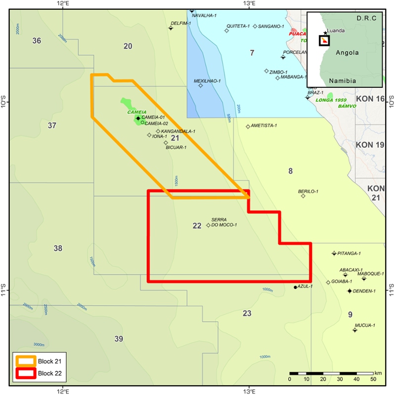
Beyond these illumination challenges, broadband seismic provides deep imaging due to its extra low frequencies and sharp resolution of small features with the higher frequencies. CGG has recently acquired a new multi-client seismic broadband 3D dataset offshore Angola in Blocks 21 and 22. The Block 21 dataset covers approximately 2,915 km2 including the recent Cameia discovery. Data are still being processed but a fast-track pre-stack depth migrated volume has already been delivered. Block 22 benefits from full pre-stack time-migrated and depth-migrated volumes covering a total area of 4,300km2.

South Atlantic margin equivalence
The South Atlantic rift basin evolved as a main branch of the Jurassic-Cretaceous rift zones between Africa and South America during the final stages of the break-up of western Gondwana. When juxtaposing the Africa and Brazil conjugate margins in a reconstruction of the initial opening of the South Atlantic (around 140 Ma) the Brazilian Santos and Campos Basins can be seen to be located adjacent to Africa’s Benguela and Kwanza Basins. The tectonic history demonstrates the fact that the pre-salt play that led to the discovery of the giant Lula field in the Brazilian Santos Basin can be used as an analogue offshore Angola. The Lula oil field offshore Brazil was discovered in 2007 by Petrobras in water depth of approximately 2,000m. Hydrocarbons were encountered beneath the Aptian-aged evaporites within a lacustrine carbonate reservoir.
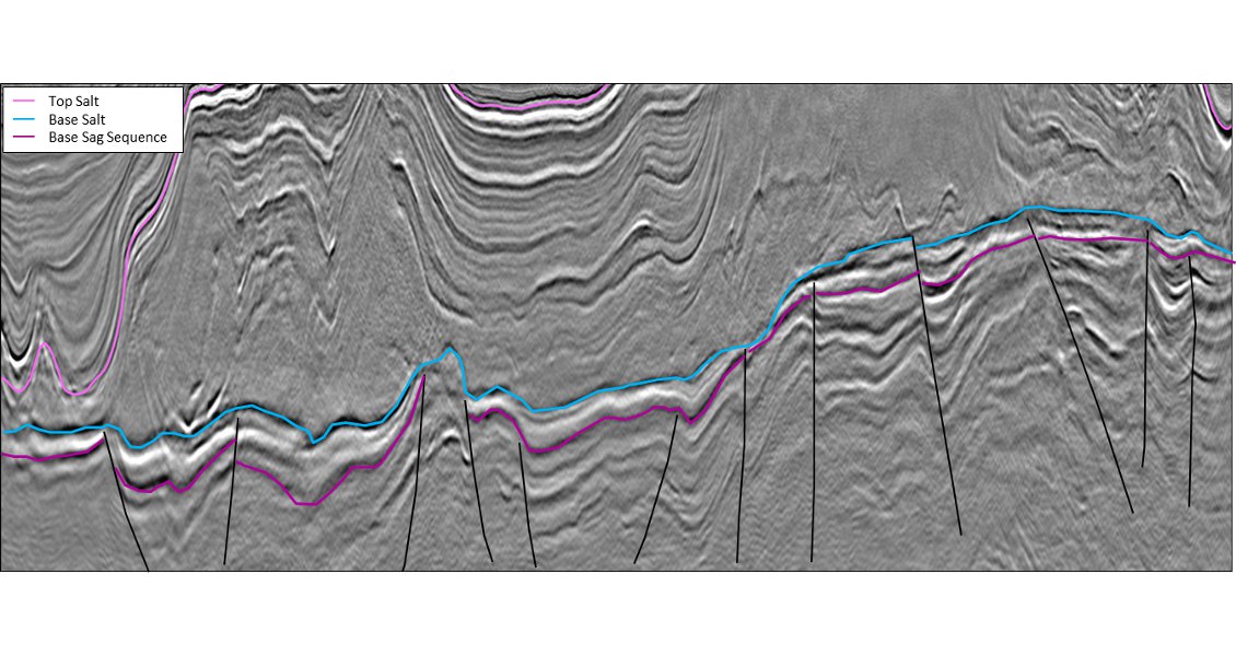
The figure below displays a sample section from CGG’s broadband survey acquired in the northern part of the Santos Basin in Brazil. It demonstrates the similarities existing between the Brazilian margin basins (Santos and Campos) and the Kwanza Basin in Angola as seen in the other images in this article. The low frequencies at depth highlight deep rotated fault blocks, as well as the correlation of syn-rift sedimentary packages, the thickness of the sag sequence, and base and top of the evaporite section (i.e. salt domes and salt welds), all direct analogues of the geological features identified in Angola Block 21.
Kwanza pre-salt discoveries
The first well discovering oil in the pre-salt section of the Kwanza Basin ultra-deep water (i.e. beyond 500m depth) was Baleia-1 in 1996. This well encountered good oil shows over a gross interval of about 120m. In 2011, as a result of recent deepwater discoveries in Brazil, Maersk drilled the Azul-1 pre-salt discovery in Block 23 and this was shortly followed by Cobalt’s high-impact Cameia-1 discovery well in Block 21.
The Cameia-1 well was drilled to a total depth of 4,886m into highly permeable fractured carbonates of Aptian age. A 360m gross oil column was encountered. It flowed at a restricted rate of 5,010 barrels of 44° API oil and 14.3 MMcf of gas per day. The oil leg is expected to extend into the deeper syn-rift section. Cameia is the first pre-salt discovery in Angola to benefit from broadband seismic coverage, which should help to better delineate the full extent of the oil accumulation.
Salt structures
Due to various episodes of relative uplift/subsidence of the West African continental margin, sediments overlying the Aptian evaporites have slowly migrated down slope, with the salt acting as a ductile decollement layer.
As a consequence, the post-salt sediment section is affected by a predominantly extensional regime in the shallower updip part of the Kwanza Basin whilst downdip the sediments underwent compression.
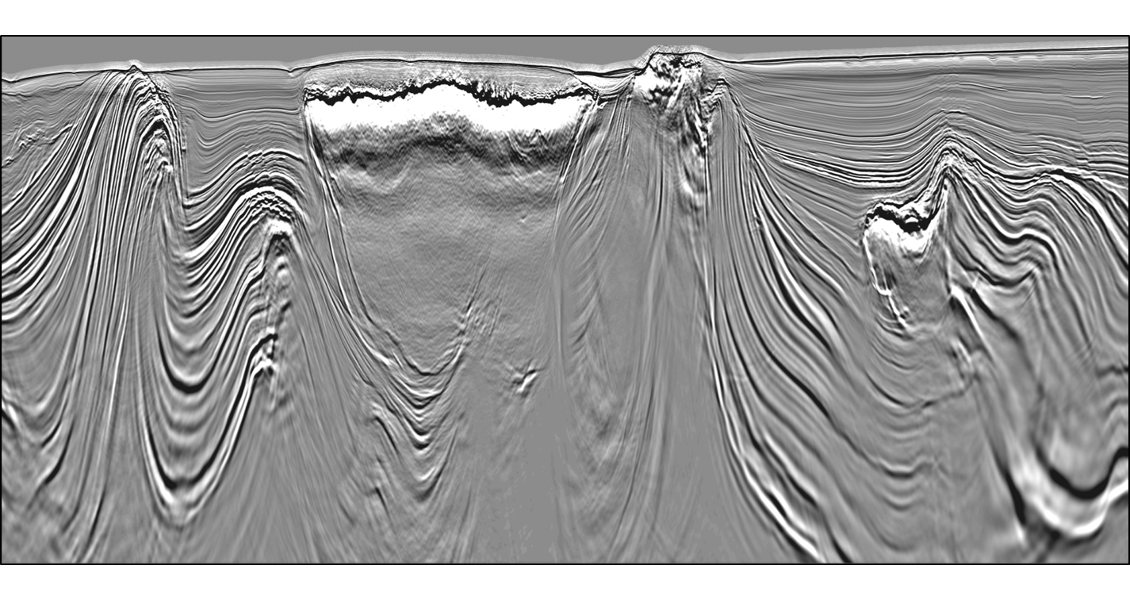
The combination of gravity sliding processes and salt deformations has resulted in the variety of salt structures we observe today in the Kwanza Basin which makes seismic imaging such a challenge. Besides the obvious wavefield illumination complexities, broadband seismic helps to better image sub-salt sediments with the addition of the extra low frequencies, while at the same time allowing for a sharper definition of the edges of salt bodies due to the higher-frequency content, as seen from the figure below. For example, Angola Block 21 is located in a predominantly extensional area where smooth salt domes and local salt welds are seen on seismic data (main image at top of page) whilst Block 22 covers an area dominated by compression stresses where detached salt diapirs, large canopies and overhanging sediments are observed.
Mapping channels
Deepwater turbidites deposited on top of the Albian carbonates and Aptian evaporites constitute another important target within the highly deformed sediments of the Upper Cretaceous to Tertiary section. These reservoir sands were only deposited locally on the Kwanza Basin margin, which means it is of high importance to accurately track turbidite channels and good quality sands that can potentially be trapped around or beneath salt-related structures.
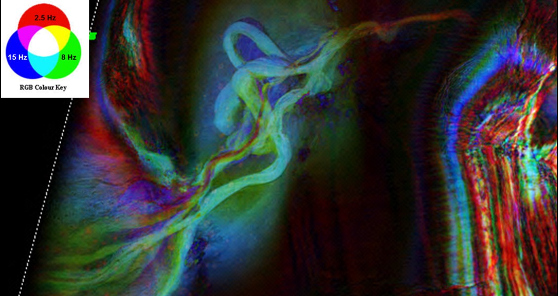
Broadband seismic data has brought a new level of understanding to the mapping of these facies. Using the full spectrum of frequencies (from 2.5 Hz to 125 Hz) we are now able to highlight greater details of the turbidite facies distribution.
The figure below shows an example of 3D frequency decomposition and colour blend from the Block 22 broadband dataset, where we can clearly identify a turbidite channel complex with various phases of sediment fill, meander growth and incisions. This kind of information is key to tracking reservoir sands around potential traps provided by salt structures and thus helping explorationists to find further oil reserves in West Africa.


