“We did not want the same unexpected situation like we had at Ekofisk,” recalls Ola Eiken, CEO of Quad Geometrics. He refers to the discovery of 2.5 m of seabed subsidence that had occurred since the start of oil production. “When Statoil was preparing the Troll oil and gas field for start-up in 1995, we wanted to monitor subsidence from the start.”
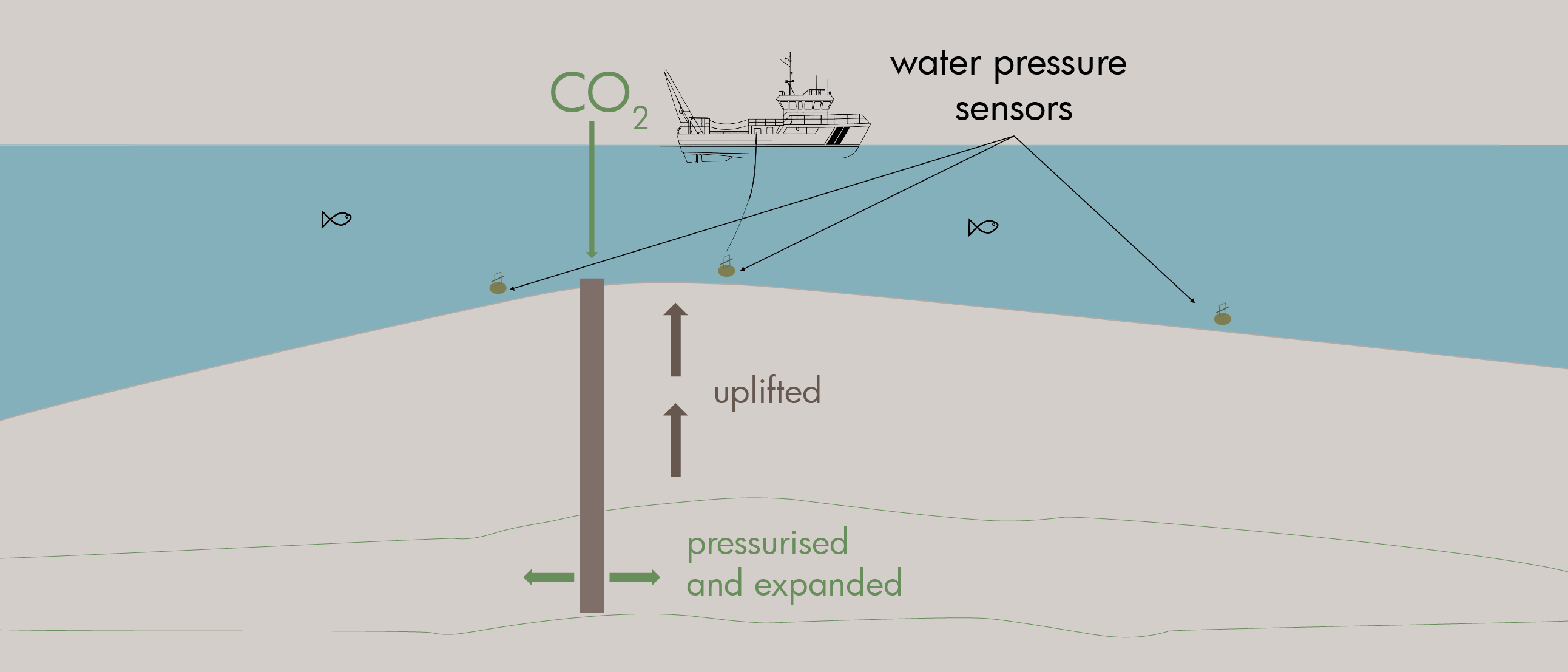
Echosounders, the standard at the time for seabed measurements, were too imprecise. A colleague of Ola suggested a simple solution: Measure the water pressure!
“The method proved to be very precise, with 2-3 mm accuracy at 300 m depth – on par with onshore measurements. I think many people did not realise the precision that water pressure measurements provide,” Ola continues.
Trondheim-based Quad Geometrics specialises in high-precision measurements of gravity (gravimetry) and vertical movements, offshore and onshore. Twelve years ago, Ola brought his expertise and technology from Statoil into the company, which he started together with a colleague from the Scripps Institution of Oceanography in San Diego.
From subsidence to uplift
The method is simple: Pressure sensors are placed on a pad on the seabed, record data for a few minutes before the pressure sensors are moved with a remotely operated underwater vehicle (ROV) to the next measurement point. A network of reference sensors outside the measurement area provides the necessary corrections, including for tides.
I think many people did not realise the precision that water pressure measurements provide.
Ola understood early on that the technology is also well suited to monitoring uplift. Where oil, gas or groundwater extraction contributes to subsidence, fluid injection results in the seabed being lifted up.
Since 2021, Quad Geometrics has taken part in the SHAPE (Seafloor Height from Aqua PressurE for offshore CO2) research project together with Equinor and NGI. The project investigates measurement methodologies related to offshore CO2 storage.
“For large-scale CCS projects, understanding and managing pressure is crucial. Storage capacity depends on compression of the formation water and pore expansion. The expansion causes uplift – and by measuring this, the capacity increase is directly quantified,” Ola explains.
An under-communicated factor
Repetitive seismic measurements (4D) are considered the gold standard for tracking the CO2 cloud in a reservoir, such as at Sleipner (since 1996), Snøhvit (since 2008) and soon at Northern Lights’ Aurora – Norway’s first commercial CO2 storage.
“But seismic data does not show the pressure in a reservoir very well. The pressure increase moves faster and affects a larger volume of the reservoir than the greenhouse gas itself,” Ola points out.
For large-scale CCS projects, understanding and managing pressure is crucial. Storage capacity depends on compression of the formation water and pore expansion. The expansion causes uplift – and by measuring this, the capacity increase is directly quantified.
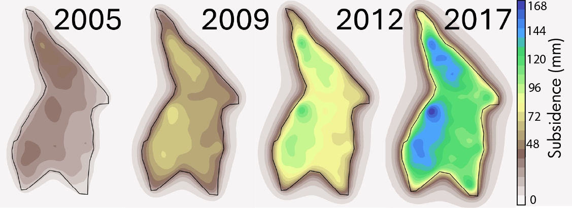
He believes that pressure measurements have received too little attention. Good pressure control can be crucial for the success of large-scale storage of CO2. Snøhvit illustrates this. Shortly after injection began in the Tubåen formation in 2008, the pressure rose sharply near the well.
“The problem was that the reservoir experts did not have much information about what was happening some distance away from the well. Models suggested barriers and poor formation properties in certain parts of the reservoir, but it was not possible to get to the bottom of this.”
The decision to switch injection to another formation (from Tubåen to Stø) was made in 2011. Ola emphasises that broader pressure information could have provided a better insight into the reservoir conditions in Tubåen. Perhaps based on this information, a switch to Stø would have been made at an earlier time, or perhaps the reservoir challenges in Tubåen could have been handled?
Conflicts
Pressure can also create conflicts with neighbours. In academic circles – and most likely also internally in companies – it has been discussed how adjacent licenses for CO2 storage can affect each other. This will also have to become a topic for the authorities’ supervision of the business.
The Troll aquifer, which the Northern Lights will use, extends across several licenses for CO2 storage on the Horda platform. If neighbouring operators also begin injection in the coming years, they will therefore share the same storage space. And it is ultimately the pressure that determines how large volumes of greenhouse gas can be stored in a given formation.
In this context, there are still unanswered questions related to whether the companies can operate side by side with predictable storage capacities and not least how to optimise injection strategies for best utilisation of the capacity without one operator outcompeting other operators within one aquifer.
“Pressure is an under-communicated factor in this context,” says Ola.
The future of pressure measurements
The SHAPE project is in its final phase, and the results could be of great benefit to a future industry on the Norwegian continental shelf. Little work has been done on this type of measurement of offshore CO2 storage previously.
He hopes that the SHAPE project will help elevate the role of pressure in the CCS debate, i.e. to put the value of such information, and the challenges associated with pressure increases in reservoirs, higher on the agenda.
“For Equinor, this is of course relevant knowledge. They have a lot of data on subsidence at Troll, and are involved in CCS projects both southwest of Troll (Northern Lights) and east of Troll (Smeaheia).”
The existing Troll measurement network is therefore in a very favourable position, and an expansion of the network into the adjacent CCS licenses will have a limited cost.
“Within the SHAPE project, we have had discussions about the way forward for the technology. Some see the value of such pressure measurements, while others are still unsure whether the measurements will be accurate enough to register relatively small changes on the seabed.”
Regardless, Ola is convinced that pressure will increasingly be a topic of discussion when we plan for future CO2 storage on the Norwegian shelf. “Then it is important to have good solutions for how we can register this parameter over large areas in a cost-effective manner. The measurements at the Troll field have demonstrated over 25 years that this is possible.”