A catalyst of change for net-zero
How can state-of-the-art AI tools be used to better understand the subsurface and make more informed decision on the suitability of storage sites for carbon sequestration projects?
Artificial intelligence (AI) is making big waves in the subsurface world. In recent times, advanced neural networks have demonstrated their ability to surpass traditional attribute analysis in identifying, delineating, and extracting faults from seismic data. This isn’t the first appearance of AI within the realm of seismic interpretation: neural networks have been used for years to improve the extraction of geobodies. So, it is only natural that horizon interpretation receives its long overdue upgrade.
AI seismic interpretation: the Implications for subsurface analysis
Seismic interpretation can broadly be separated into three components: faults, horizons and geobodies. While these elements are vitally important to define traps and accurately estimate the storage potential of a structure, their interpretation is very time-consuming. This is where AI, supported by modern day computing power, can drastically reduce the time required to undertake a detailed seismic interpretation, without sacrificing accuracy.
The ability to undertake quick and reliable subsurface analysis is crucial for any project involving seismic data, especially with data sizes increasing at an exponential rate. In most projects, the likelihood of several end products of the interpretation are often measured using a P10, P50 and P90 threshold. However, the initial interpretation is rarely treated this way. As the different elements – faults, horizons and geobodies are reviewed by peers and subsequently accepted as the absolute truth, this inevitably introduces interpreter bias. AI can be effectively deployed to reduce underlying bias. Extracting faults, horizons and geobodies in this manner will create a more ‘neutral’ response, which can be influenced using interpreter-guided fine-tuning. Furthermore, these results are generated far quicker than manual interpretation, without any drop-off in quality.
Why is CCUS essential in the transition to net-zero?
AI seismic interpretation can be implemented for Carbon Capture, Utilization and Storage (CCUS) projects where subsurface investigation and interpretation is vital for success. The primary aim of CCUS is to capture and successfully store CO2 within the subsurface to prevent net carbon emissions from largescale industries entering the atmosphere. To successfully deliver CCUS projects, a detailed interpretation of the subsurface is required across two distinct areas. Firstly, site location and assessment, where a subsurface structure is identified for CCUS purpose. Secondly, containment and monitoring; the ability to track the fill and storage of CO2 in the subsurface for an extended period of time after injection.
Assessing potential CCUS site locations
A suitable CCUS target is a necessary first step in any project. Identification of a structure of sufficient size and storage capacity is driven by the seismic interpretation, with faults and horizons playing a lead role. Horizons and faults will constrain the extent of a structure. Faults may also dramatically affect the sealing capacity and directly impact the ability of a structure to fill with CO2 by compartmentalizing the aquifer and subsequently controlling fluid-flow pathways through it.

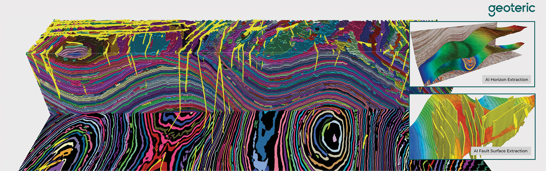
The manual interpretation of faults can be extremely time-consuming, and the interpreter’s decision-making process may vary throughout. A further pressure is introduced by the need to simultaneously interpret horizons. Time constraints and inconsistencies in fault detection and interpretation may lead to mistakes which can be costly or even critical to a positive outcome with regards to CO2 storage. Therefore, the ability to extract faults with a high level of consistency and limited interpreter bias and variability is crucial. As illustrated in the lower inset image to Figure 2 (main foldout), AI fault detection networks can be used to reveal the lateral and vertical extents of the faults. Furthermore, the ability to fine-tune a fault detection network enables an interpreter to guide the algorithm to better identify and delineate faults within a specific seismic volume.
It is generally accepted that with increasing structural complexity, stratigraphic horizons will take longer to interpret (Figure 3). Therefore, having the ability to automatically identify and extract faults and horizons in a seismic volume will free up a significant portion of an interpreter’s time to concentrate on areas of complexity. As shown in Figure 2, the volumetric extraction of horizons in this seismic volume revealed two mounded structures. One of them is a potential site for CCUS, while the other has a greater risk of seal breach, due to the larger number of faults present over the crest of the structure. A regional unconformity is clearly identified along with all the underlying offlaps. This can further assist in understanding the lateral extent of both aquifer and seal units. AI can enable interpreters to speed up their work without any loss of accuracy.
Efficient containment and monitoring
Once CO2 storage commences, the injected gas should be tracked and mapped within the aquifer. This is vitally important as it may identify compartmentalization, unforeseen leaks, and spill points, as well as high and low fluid-flow pathways. The ability to track the fluid fill can be achieved with geobodies.

Machine learning-based algorithms can analyze the seismic data to identify and capture the detailed and accurate extents of the CO2 plume as a geobody. The procedure can be repeated, using the same parameters, over seismic volumes of varying vintages and/or offsets. As shown in Figure 4, a series of geobodies have been generated based on seismic data acquired before and at various times after the commencement of CO2 injection. The gas plume identified in the first repeat survey is the blue geobody, while the green and red geobodies represent the changes in its extents as the structure fills. Based on the volume of the geobodies and the reservoir properties, the amount of CO2 stored in the plume can be calculated and then compared to that of the injected CO2. If there is significant difference between these two numbers, there may be a leak-off point in the aquifer/reservoir impacting the fill/storage potential of the structure.
Quick, accurate and reliable results
The examples shared illustrate how AI can be used to further assist in subsurface examination of the Earth. In CCUS projects the automated horizon extraction and the identification of any intercepting faults help us meet the requirements for quick, reliable, consistent and repeatable interpretation. With the ability to fine-tune a network to a seismic volume’s specific style of faulting, the interpreter is enabled to guide the AI solution to create even greater results. Involving the interpreter is crucial throughout, as they have the necessary experience, knowledge and skills. AI is only helping them along the way to complete the work, saving time and improving the quality of results.
Acknowledgements
We would like to thank the National Data Repository (UK), Geoscience Australia and Sleipner Group for access to the seismic volumes and well data used throughout this study.