28 years after Saga Petroleum AS made the H-Central oil discovery, Equinor has returned to explore for more volumes in the Draupne Sandstone as it targets the Fjell prospect. Here is a brief history on the hunt for Upper Jurassic oil in the area.
The first: H-Central
The H-Central oil discovery (34/7-21) proved two oil columns named the Upper and Intra Draupne Sandstone Units, referred at the time as the ‘TDS’ and the ‘IDS’ respectively. The Oil down to in the TDS was proven at 2519 m TVD. Somewhat surprisingly these two sandstones were not in pressure communication.
The lithofacies of these Draupne sandstones was also very different. The IDS was a medium to coarse grained-, turbidite sandstone with an intense brown oil stain. The TDS comprised of fine-grained moderate oil stained sandstone interlaminated with shale lamina. The TDS was interpreted to represent a shoreface environment within a subtle progradational cycle and with possible tidal influence.
The well was tested and the 2510.5-2537.5 m interval, covering the main part of the Upper Draupne Sand, flowed at a steady oil rate 884 Sm3/day; the corresponding wellhead pressure was a stable 146 bar and the GOR ~95 Sm3/Sm3. The IDS was not tested.

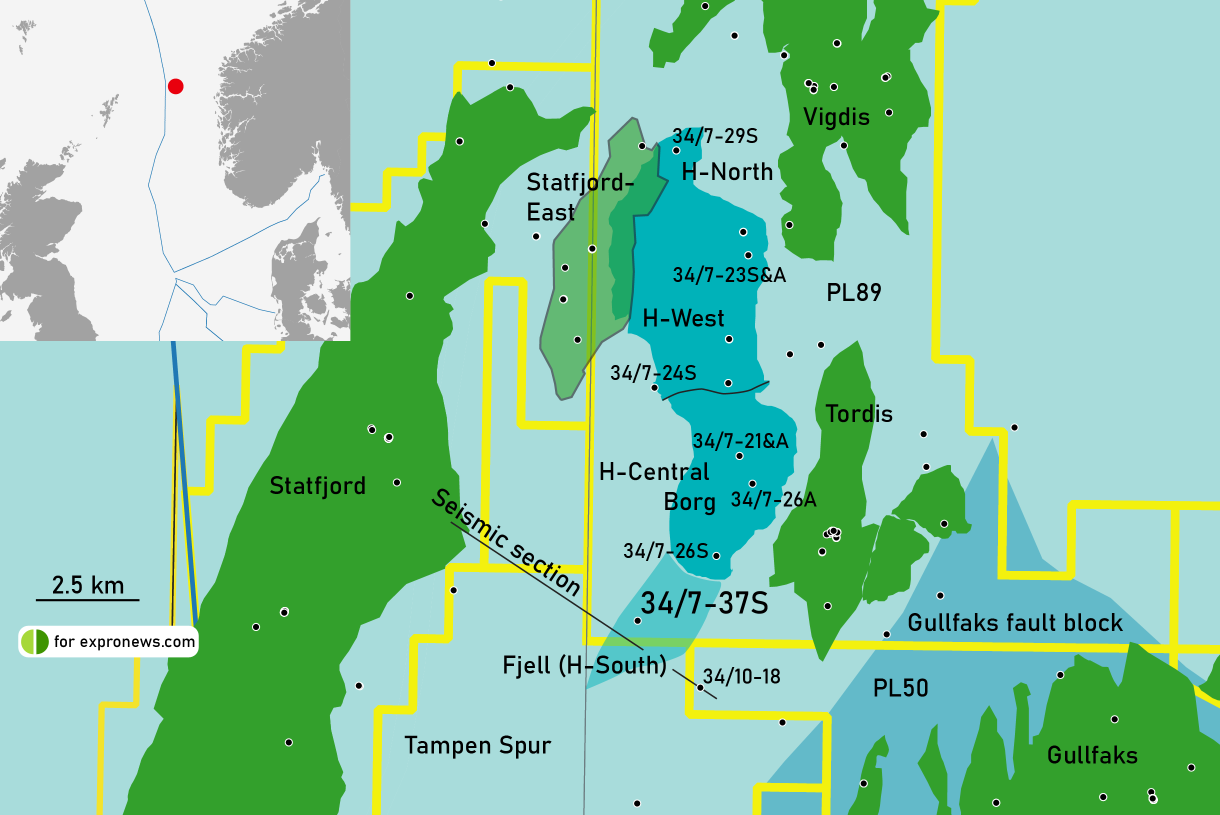
Connected to Statfjord
Based on the pressure measurements, it was concluded that the TDS oil-bearing sandstone had undergone pressure depletion caused through several years of oil production from the Brent Group sandstones in the neighbouring Statfjord Field. For this to have occurred, there had to be an upper Jurassic reservoir presence on the dip slope of the Snorre-Vigdis-Tordis mega-footwall that wrapped around to the low-side of the Statfjord East Field, as is illustrated by the overlap of the East Statfjord field and the H-West outline on the map (after Solli, 1995).
The Second: H-West
Two years later, in 1994, and with the key aim to evaluate the greater size of the H-Central discovery, Saga returned to drill the structural compartment called H-West. Well 34/7-23 S discovered more oil bearing Draupne Sandstones though of much better thickness, net to gross and quality. Once again, well -23 S, did not encounter an oil water contact. The deepest oil down to was observed at 2632 m TVD. The well was sidetracked down-dip and well -23A was drilled and again, no OWC was encountered; it proved up additional oil column with a deeper ODT being proven at 2649 m TVD.
Western limit of Intra-Draupne sands
Saga went onto appraise the H discovery in first quarter of 1995, by drilling well 34/7-24 S. The well was located in the axial position of the Upper Jurassic synform (see cross-section below) located east of the Statfjord East fault (SEF). This well only encountered a mudstone-dominated Draupne Formation, so it delimited the maximum progradation limit for the Upper Draupne Sandstone whose shoreline was trending circa north –south on the Tordis-Vigdis footwall. It also downgraded the lower and middle Draupne Formation since no gravity flow sandstones were encountered.
The third: H-North
In 1998, Saga returned to appraise the H-Area discoveries in 1998 and drilled 34/7-29 S. The main objective of this well was to test the H-North compartment. It was mapped to be a northerly extension of the oil bearing Upper Jurassic Top Draupne Sands penetrated in wells 34/7- 21, 21A, 23S & 23A.
Seismic interpretation of the reservoir interval indicated communication with the H-West area. A total of 18 m of oil-bearing sands were encountered in the Top Draupne Sandstone. Again, no oil water contact was encountered and from pressure data the ODT was proven to be equivalent to 2622 m TVD MSL.
Borg field
The H-Central discovery went on to be developed as the Borg Field. Production wells were tied back into the Tordis template from where the oil is exported south to the Gullfaks Platform in PL050 Block 34/10. The H-North and H-West accumulations were included in the Vigdis field development.
Borg Development wells
In late 1997, with the aim of conducting a six-month long-term production test, well 34/7-26S was drilled. This well confirmed the stratigraphic trap geometry to the H-discovery: southerly shale out of the TDS was encountered in 34/7-26S. The well was sidetracked to the north and an expanded 50 m thick TDS was found in 34/7-26A confirming a diachronous base to the TDS reservoir. The IDS was also oil bearing.

And now, Fjell (or H-South)
Finally, in 2020, the original mapped ‘H-South’ compartment is now being explored under the name of Fjell. It is however the same structural compartment as H-South and the trap is still dependent on the base seal and top seal relationships as proven in H-Central in 1992.
The base seal is also further proven since water wet Brent sandstones were found in the up-dip well 34/10-18 drilled in 1993. Statoil did not encounter a TDS in the latter well so the key risk in Fjell is judged to be reservoir presence.
JOHN WOOD
Note: the Upper Jurassic Draupne sandstone discoveries have been coloured blue for illustration purposes; it has no implication on reservoir fluids.