The Pre-Salt reservoirs in Brazil are home to some of the world’s largest oil and gas reserves and one of the most exciting exploration frontiers. However, until now the exceptional depth of more than 5,000 m below sea level with around 2,000 m of salt overlying the reservoir, has caused significant challenges to de-risk locations for drilling exploration wells.
The industry therefore needs to capitalize on any data that already exists from these reservoirs. Here, we describe how digital core data forms a key part of the solution, providing a continuous dataset along cored intervals in addition to the traditional plug measurements.
A new solution required
Historically, exploration teams have had to make do with limited data types from core samples. The resolution of these data is usually low. They typically range from three to five core plug measurements per meter with or without essential metadata. Sparse resolution along with uncertain data quality can hinder any geological model. Data uncertainty can cloud precise decision-making, creating additional costs for acquiring new core.
Accessibility is a further issue. Without a centralized system for easy retrieval of these historical data, they are often scattered across numerous repositories. Professionals have to spend valuable time and resources locating the necessary information.
There is also the challenge of how records are stored. Until now, much of it comes in paper form. These are difficult to access and use. The transition from paper to digital formats is time-consuming and prone to errors, often compromising the integrity of the data.
These challenges underscore the need for innovative solutions – solutions that the Geotek-Solintec multiclient project now provides.
Pre-Salt digital rock catalog
The digital core catalog is ML/AI-ready, spanning two scales of measurement: the core scale (mm to m) and the pore scale (<sub to mm). At both scales, the catalog provides data that was never before acquired from these complex rock formations. The core scale is represented by hyperspectral imaging and multi-sensor core logger (MSCL) measurements of 1,164 meters of core from 16 wells. Data acquired from the cores includes ultra-high definition visible and UV images, combined with petrophysical, mineralogical, and geochemical properties.
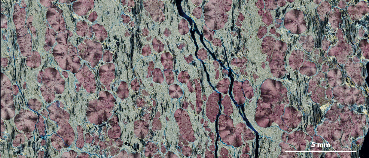
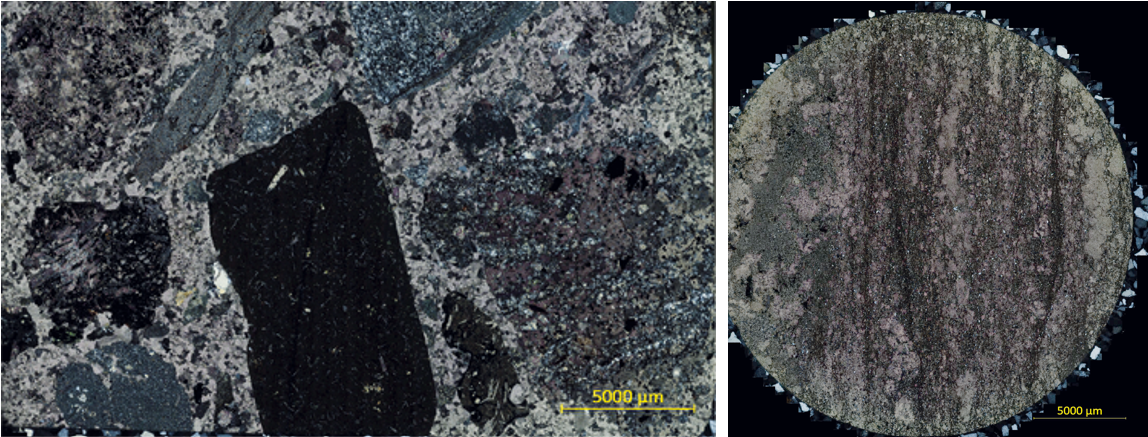
The pore-scale data is represented by digital high-resolution twins of 3,003 thin sections that correspond to the same intervals as the core samples. These thin sections offer a microscopic view of the rock’s composition and structure, providing critical insights into the reservoir’s characteristics. This level of detail is invaluable for understanding the geological and petrophysical properties of the pre-salt layers. It also perfectly complements the MSCL and hyperspectral datasets from the core.
What are the benefits of these innovations to industry experts?
The pre-salt digital catalog has yielded a comprehensive suite of deliverables, transforming how operators approach pre-salt reservoir exploration.
Digital Accessibility
All data is accessible online, enabling remote work with core data and eliminating the need for physical sample distribution.Objective Analysis
Using automated, multi-sensor technology to acquire repeatable and depth-co-registered measurements.Data Integration
Comprehensive, high-resolution data from the core to pore scale that can be used to ground-truth wireline and seismic data and cross-validate subjective visual descriptions.Geological Insight
Discover the variability of the depositional system through well-to well correlations and apply to the reservoir model and characterization.
AI/ML Ready
Depth-coregistered data from multiple datatypes that are ready for the ML/AI revolution in geoscience studies.
Using the data for lithology classification and analysis
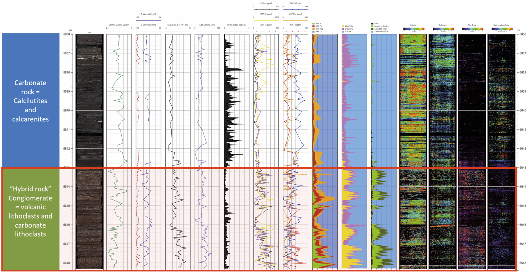
Data from the rock catalog enable early lithology classification within the Barra Velha Formation. They distinguish two facies and deliver an understanding of the geochemical and mineralogical distribution within and between these units.
The upper section of this data example is a carbonate reservoir dominated by calcite with 1 m thick intervals of dolomite. These rocks are hydrocarbon-bearing with evidence of the dolomite-rich intervals having a lower proportion of hydrocarbons. A sharp contact at 5,643 m spells the introduction of a conglomerate. This is rich in volcanic lithoclasts interpreted from the reduction in carbonate mineralogy and the elevation of silicon (Si), aluminium (Al), iron (Fe), and titanium (Ti), with a decrease in calcium (Ca) and magnesium (Mg).
The hyperspectral imaging shows that these facies of the Barra Velha Formation have 1-2 m thick clay intervals composed of smectite and montmorillonite, and lower amounts of illite dispersed throughout. The clay is derived from the volcanic clasts within this conglomerate, which were re-worked during its deposition.
The elevated magnetic susceptibility, indicative of clays and volcanics, combined with generally erratic chemical and mineralogical downcore profiles, all support a heterogeneous conglomerate facies. The identification of pore-filling clay intervals, pervasive across the core, combined with the heterogeneous nature of the facies all contribute to a reduction in reservoir quality. This is why the hydrocarbon content is lower in this section.
These conglomerate rocks, with their pore-filling clay and the nature of their clasts, could become an important marker bed and regional barrier to hydrocarbon production – essential for the geological model.
Unprecedented access to high-quality, objective data
The digital rock catalog is delivered with visualization software and represents significant progress in the geological evaluation of these pre-salt reservoirs. Exploration teams now have access to a wealth of high-quality, objective data, surpassing what was previously available. This means:
- More informed decision-making
- Reduced risks
- A saving of time and money
- Enhanced understanding of valuable resources
Through this pioneering work, Geotek and Solintec have advanced the level at which geological data is available for pre-salt operators in Brazil. Learn more about the benefits to your specialist research work from the Geotek Solintec Pre-Salt Reservoir Digitalization Project.