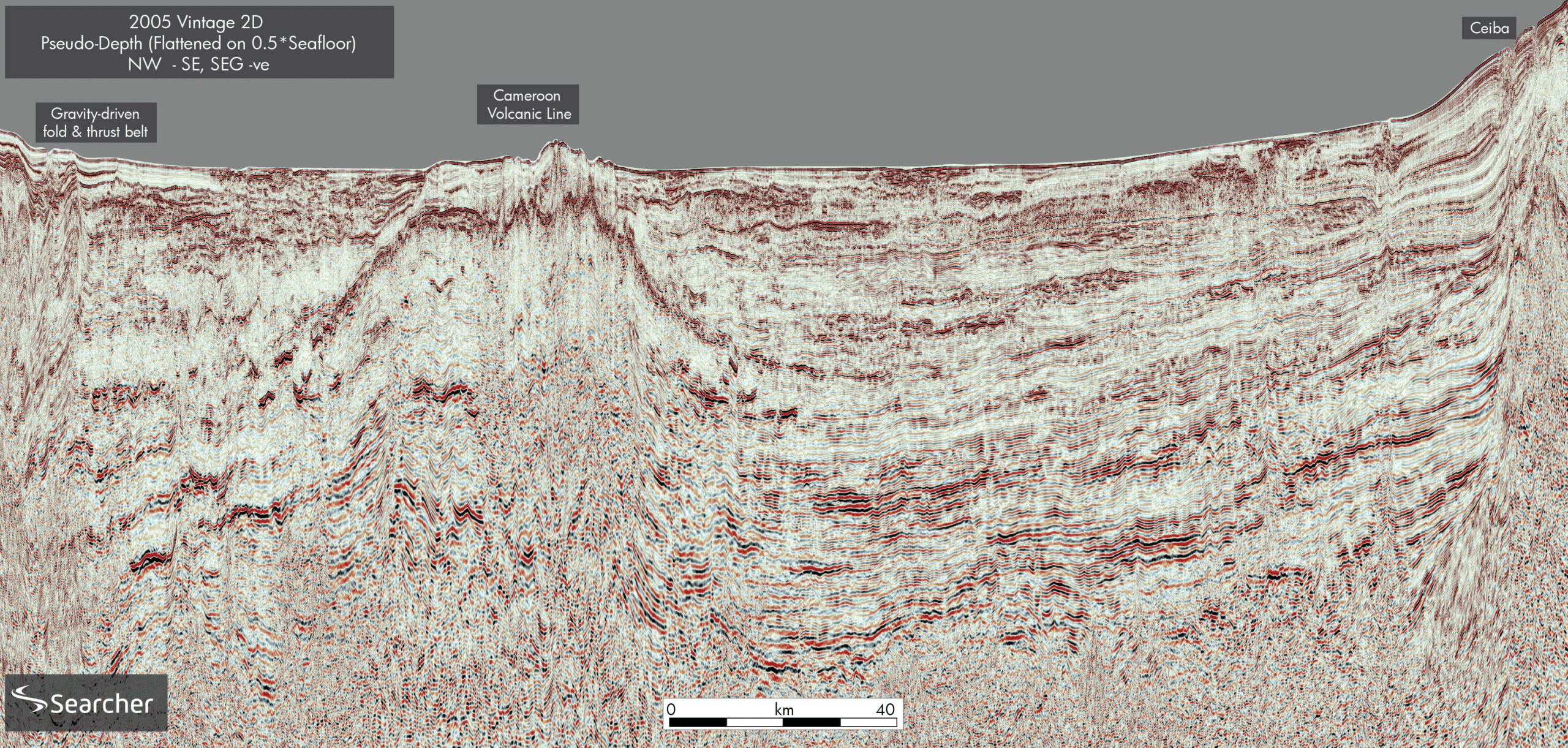
Representative dip section across the deepwater Douala–Rio Muni Basin showing key stratigraphic boundaries and the structural influence of the Cameroon Volcanic Line (CVL). Seismic data courtesy of Geoex MCG.
New modelling study reveals a petroleum system overlying oceanic crust offshore Equatorial Guinea
New insights into a frontier basin: Douala-Rio Muni Basin
The deepwater Douala-Rio Muni Basin (DRMB) is a non-volcanic, Mesozoic-Cenozoic rifted passive margin located offshore in Equatorial Guinea (EG), West Africa. Commercial oil and gas fields have been discovered on the shelf and slope of EG include the Ceiba and Okume fields, charged by Lower Cretaceous source rocks on thinned, continental crust, or the Zafiro and Alen-Aseng fields, which are charged by Paleogene source rocks that overlie oceanic crust of Aptian age. In comparison, the deepwater region of the DRMB east of the Cameroon Volcanic Line (CVL) has yet to yield any major discoveries.
Our analysis of seismic, gravity, magnetic, and geochemical data, was integrated in a full-lithosphere 3D basin model, revealing a mature, potentially prolific Cretaceous petroleum system extending across oceanic crust, with its potential influenced but not handicapped by the higher thermal history of the adjacent CVL.
Full lithosphere models to predict the heat flow
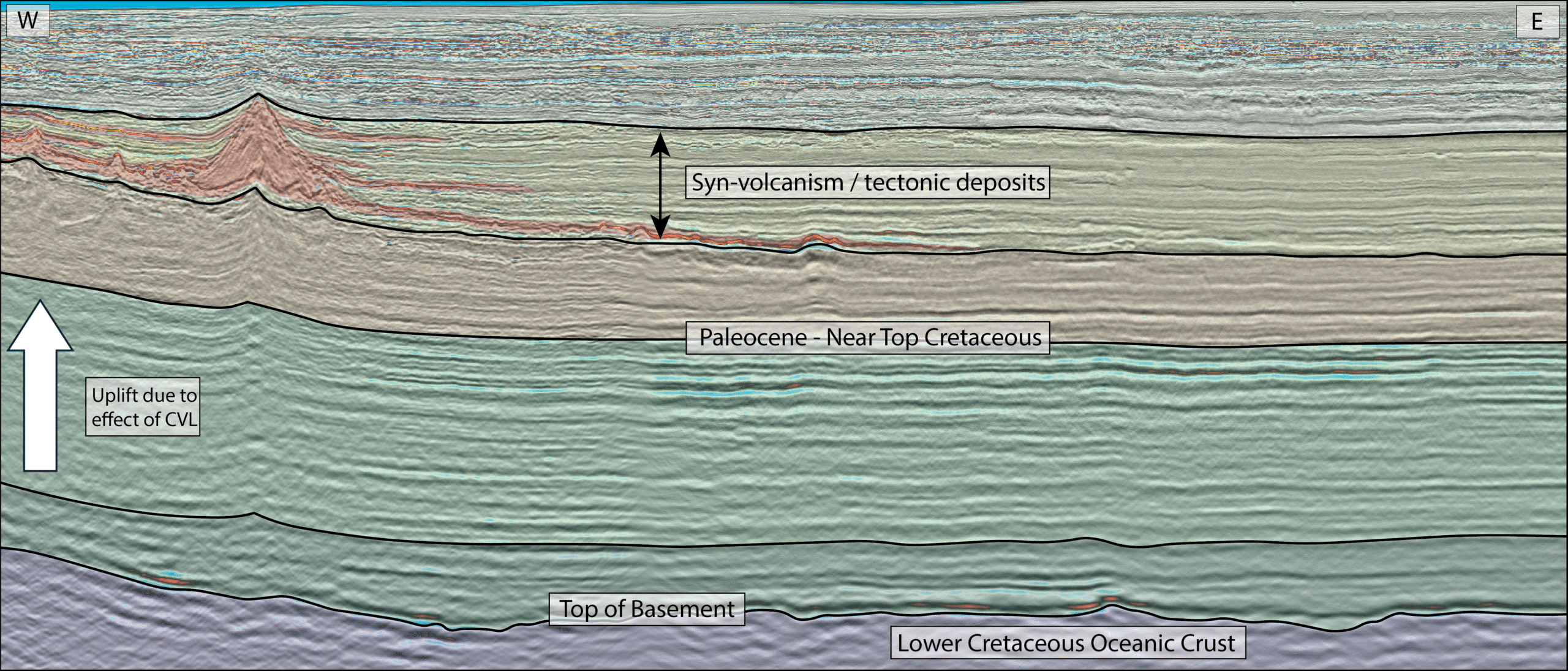
Our study area is located east of the CVL, a 1,700 km long linear chain of volcanic origin ranging in age from the Eocene to the present. The CVL has influenced the crustal, stratigraphic, and thermal structure of the Gulf of Guinea since its origin in the Paleogene. We combine five 3D seismic surveys covering approximately 7,600 km² (provided by Geoex MCG, along with 2D seismic lines, regional well data provided by Viridien Group), and gravity and magnetic surveys to create a full-lithosphere model. A newly developed gravity inversion technique enabled us to improve the accuracy of the depth to the Moho and the Lithosphere – Asthenosphere Boundary (LAB), revealing zones of mantle upwelling and increased thermal gradients beneath the deepwater region. These thermal anomalies closely align with the elongated, deep-rooted magmatic activity along the CVL and are a critical factor in assessing hydrocarbon generation in the deepwater area.
Seismic clues to reservoir and seal potential
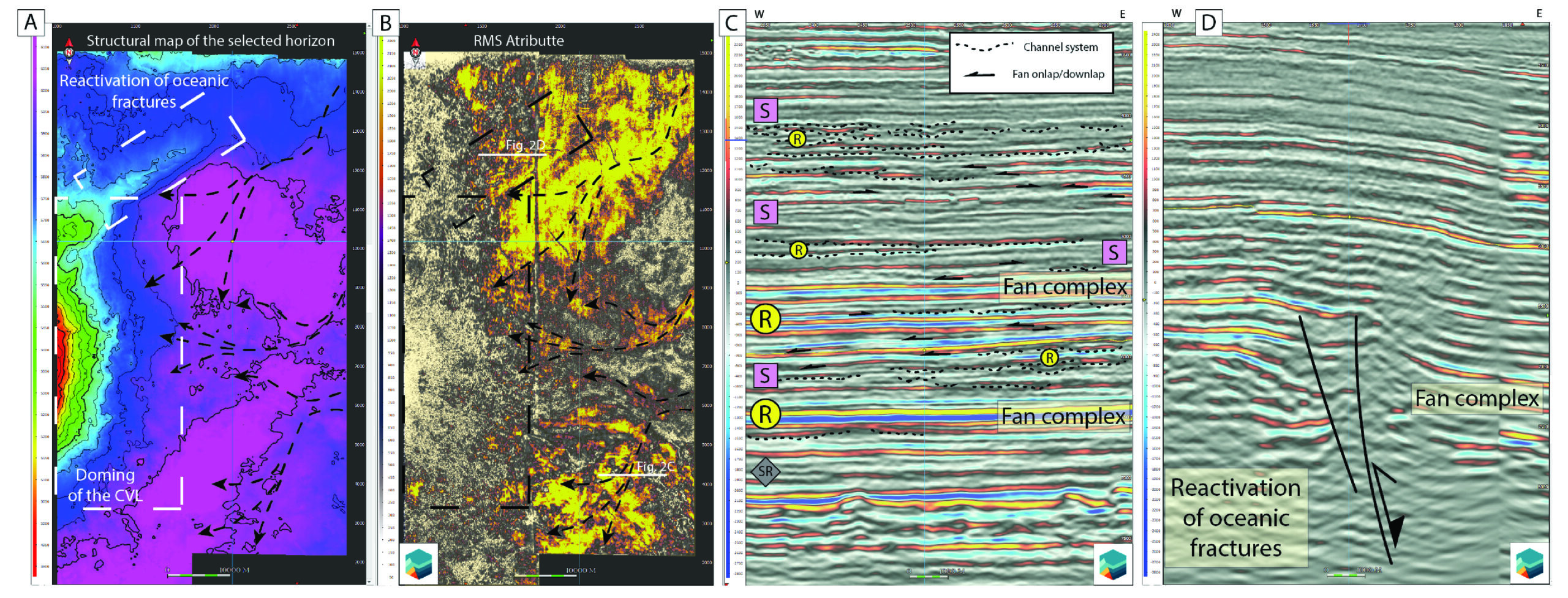
Seismic interpretation allowed the extraction of key attributes (RMS, sweetness) to identify deepwater fans and play fairways within the Albian-Campanian interval. In particular, the Santonian-Campanian channelized turbidites and basin-floor fans capped by thick mudstone packages form stacked reservoir-seal pairs. In several areas, these systems are folded or uplifted as a result of volcanic doming along the CVL. Such structural overprints also create combination traps as a potential drilling target.
Source rock potential of the region
Rock-Eval pyrolysis data from exploration wells on the shelf and upper slope of Cameroon and Equatorial Guinea (e.g., Campo R-1, Kribi E-1), combined with deepwater reference sites (e.g., DSDP 530A), allowed us to characterise and model source rock potential and compare it with the conjugate rifted margin in the Sergipe area of northeastern Brazil. The resulting source rock characterisation indicates that the Albian and Cenomanian-Turonian intervals are the primary Cretaceous source rocks in the deepwater area of the DRMB.
These organic-rich, marine clay-rich mudrocks typically contain over 2 % total organic carbon, with Hydrogen Index values between 200 and 400 mg HC/g TOC. Thermal restoration indicates original HI values in the 300 – 600 range, as observed for prolific conjugate analogues in the Sergipe Basin of Brazil. Seismic data show stratigraphic continuity between drilled source rocks on the shelf and slope to predicted source rocks in the deepwater area of the DRMB.
Hydrocarbon generation on oceanic crust
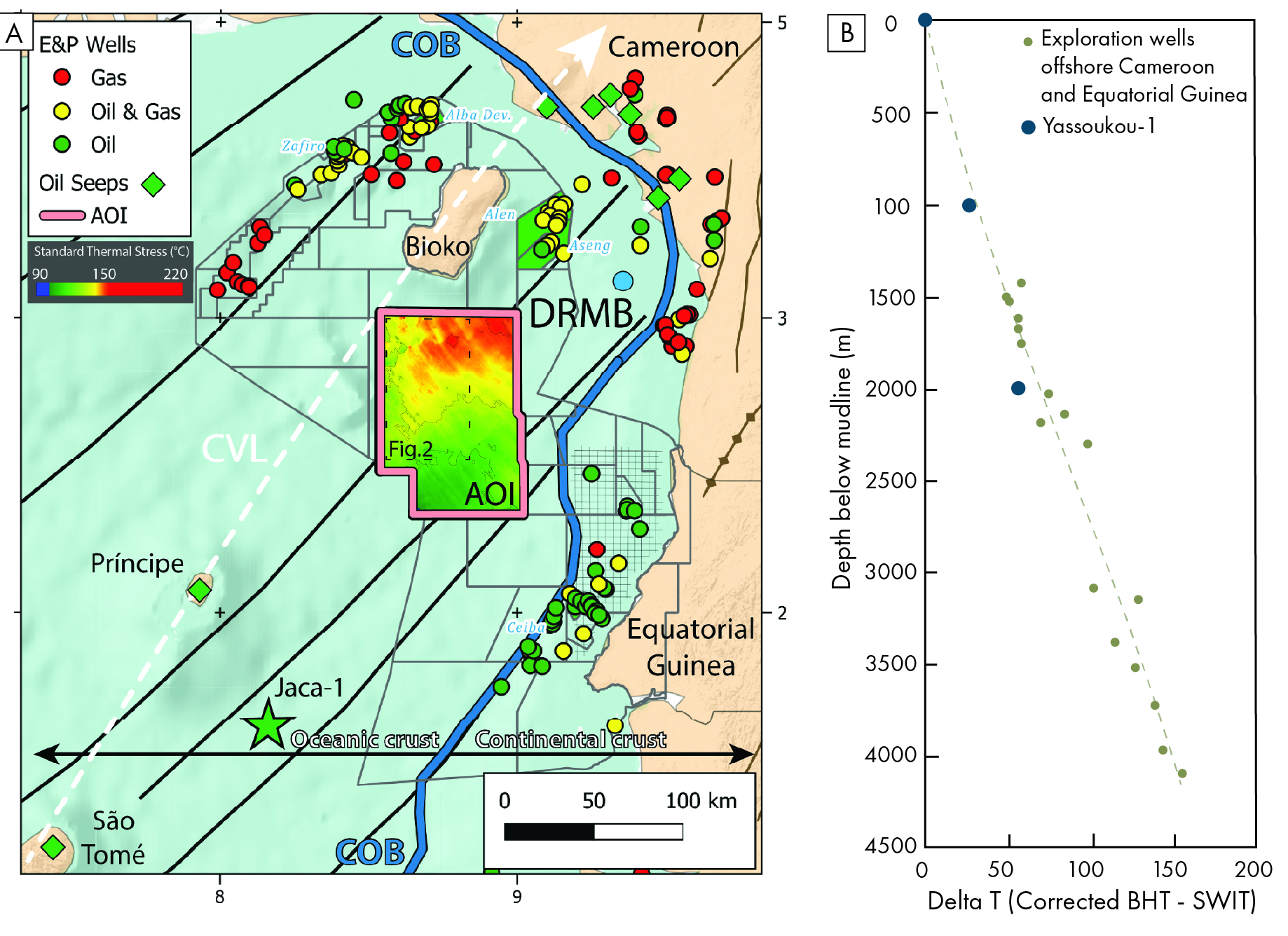
Our basin models were calibrated using corrected bottom-hole temperatures (BHTs) from regional wells and 1D pseudowells, which constrained the burial history, maturation, and oil and gas expulsion of the area. The results indicate a consistent southwest-to-northeast increase in the thermal stress gradient, aligning with the lithospheric structure of the CVL and a larger sedimentary input entering the basin along a NE – SW trend. This northeastward rise in the thermal gradient is supported by exploration data from the Jaca-1, Ceiba, Zafiro, and Alen-Aseng fields over a distance of 600 km.
The deepwater source rock intervals are present within the transitional zone from oil to gas-condensate expulsion windows across the study area. 3D models confirm significant oil and gas generation, with the northeastern sectors exhibiting more advanced maturation and potentially higher gas-oil ratio (GOR) accumulations. This proposed directional trend to the northeast of higher gas-oil ratios fits with the production at the Zafiro and Alen-Aseng fields.
Significance of the eg petroleum system
By integrating seismic, geophysical, geochemical, and thermal modeling, this study proposes a working Cretaceous petroleum system developed above oceanic crust of Aptian age.
Given the presence of hydrocarbon seeps on São Tomé and Príncipe and shows in the Jaca-1 well drilled in 2023, the DRMB’s deepwater sector east of the CVL provides a promising exploration target. The next steps include constraining the thermal and crustal framework and identifying the optimal trap and migration pathways.
The implications of this study go beyond Equatorial Guinea. The DRMB shares a similar history of rifting and depositional history with its conjugate in the Sergipe-Pernambuco Basin of northeast Brazil. Insights from our research can guide deepwater exploration approaches in both regions of the South Atlantic, especially in frontier oceanic areas that are often overlooked.