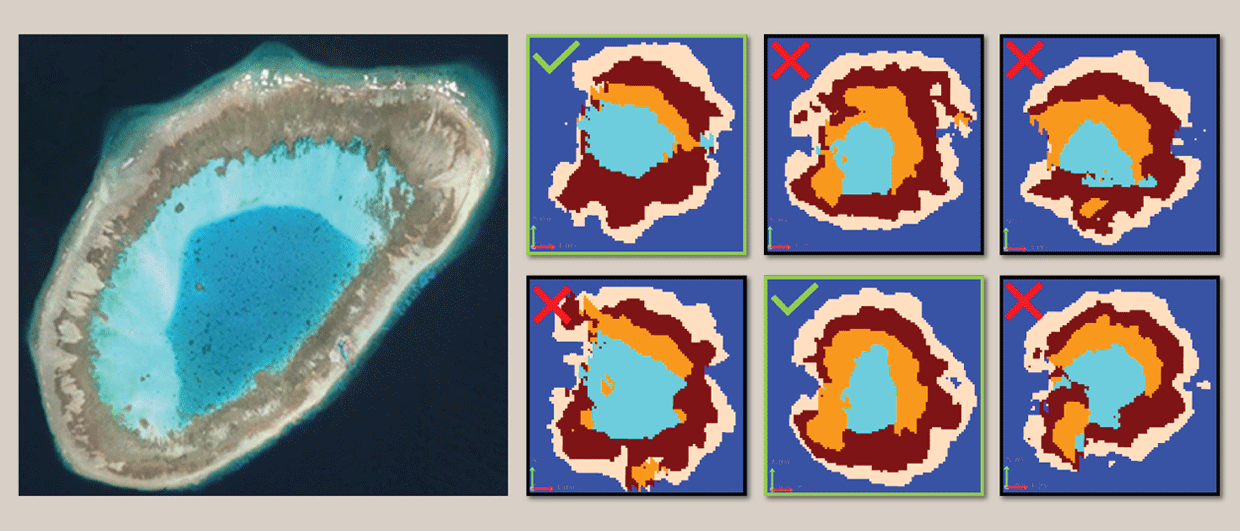
Satellite photo of the Erica Reef in Malaysia and corresponding MPS realisations. Note that it is the architecture of facies belts MPS can model correctly, even though there are less representative cases too.
Is Multi-Point Statistics the future of reservoir modelling?
We will be surfing the summer mood by diving into the realm of Multi- Point Statistics (MPS) and how this algorithm can be considered as the future of geomodelling
In our quest to build more realistic reservoir models, we stumble upon the challenge of how to fill up the blanks between well data. Many robust algorithms are widely used in the industry to overcome this problem, with Kriging and Sequential Gaussian Simulation as one the most important candidates, both with their pros and cons. But with computer power capability going up all the time, the MPS algorithm is now looking for a more widespread usage.
MPS uses training images as the backbone to understand the variability of a sample point and its direct neighbours. The idea is to go beyond the variogram limitation used in Kriging by capturing complex transitions and lateral variation between different geological facies. MPS ultimately renders complex geology more accurately. Training images can be anything from a conceptual geological drawing to a prior object model to maps and other satellite images.
Let’s focus on the latter: The quality of current satellite imaging has increased multi-fold to the point that modern analogues can now be seamlessly used to constrain subsurface models.
The illustration shows how a high-resolution satellite image of the Erica Reef off the coast of East Malaysia, that can be used as training images for building a geological model of the Tertiary-aged carbonate reservoirs found in Southeast Asia. A minimal imaging treatment has been applied to increase the contrast between the different facies belts in order to improve the training image quality and maximize the algorithm chance of producing realistic models.
The succession of facies belts is the key here. The presence of a clear reef rim, detrital back reef area and inner lagoon are distinguishable from the satellite image and can be directly infused in the model. Detailed morphology related to the current strength and windward / leeward side of the reef controlling the thickness of the rim is also a phenomenon that can be reproduced using MPS.
While the outputs are far from perfect, some realizations managed to “make the cut” by capturing the intertwining of the five distinctive geological facies in a realistic fashion. The resulting models are worth investigating deeper as alternative scenarios for both volumetrics quantification and dynamic flow prediction.
MPS is not limited to modern day carbonate reservoirs. Fluvial systems, alluvial fans, highly fractured outcrops can also be used as training images to feed into the MPS algorithm and produce more realistic models in other reservoir settings.
In our current quest for better development of remaining hydrocarbon reserves and predicting CO2 migration and storage in a depleted field in the case of CCS projects, having an accurate reservoir picture is the prerequisite and the differentiator between a prone-to-fail or a successful development / storage project. MPS simulation is the vehicle to ensure that your facies belts are being dealt with properly.