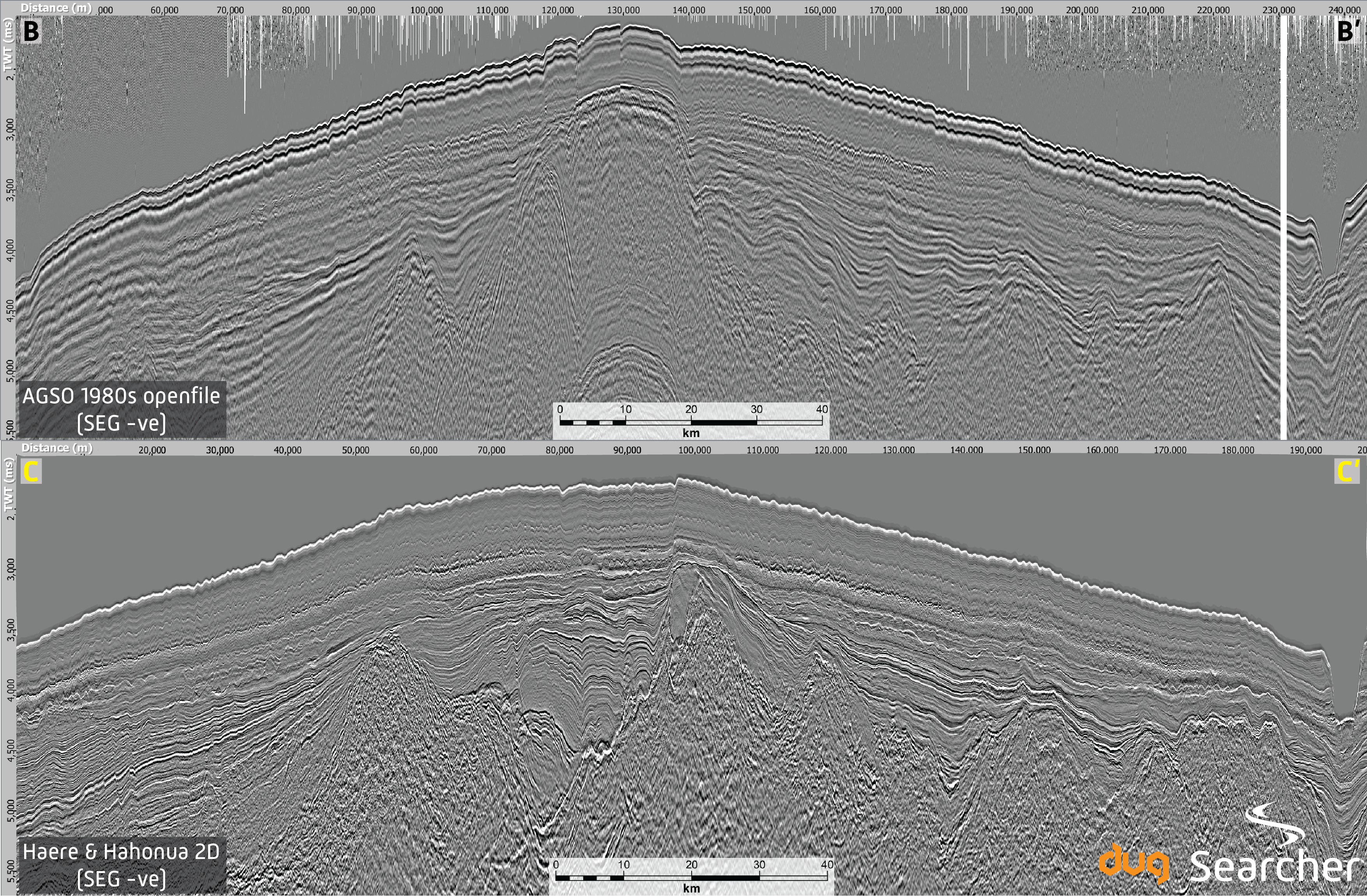
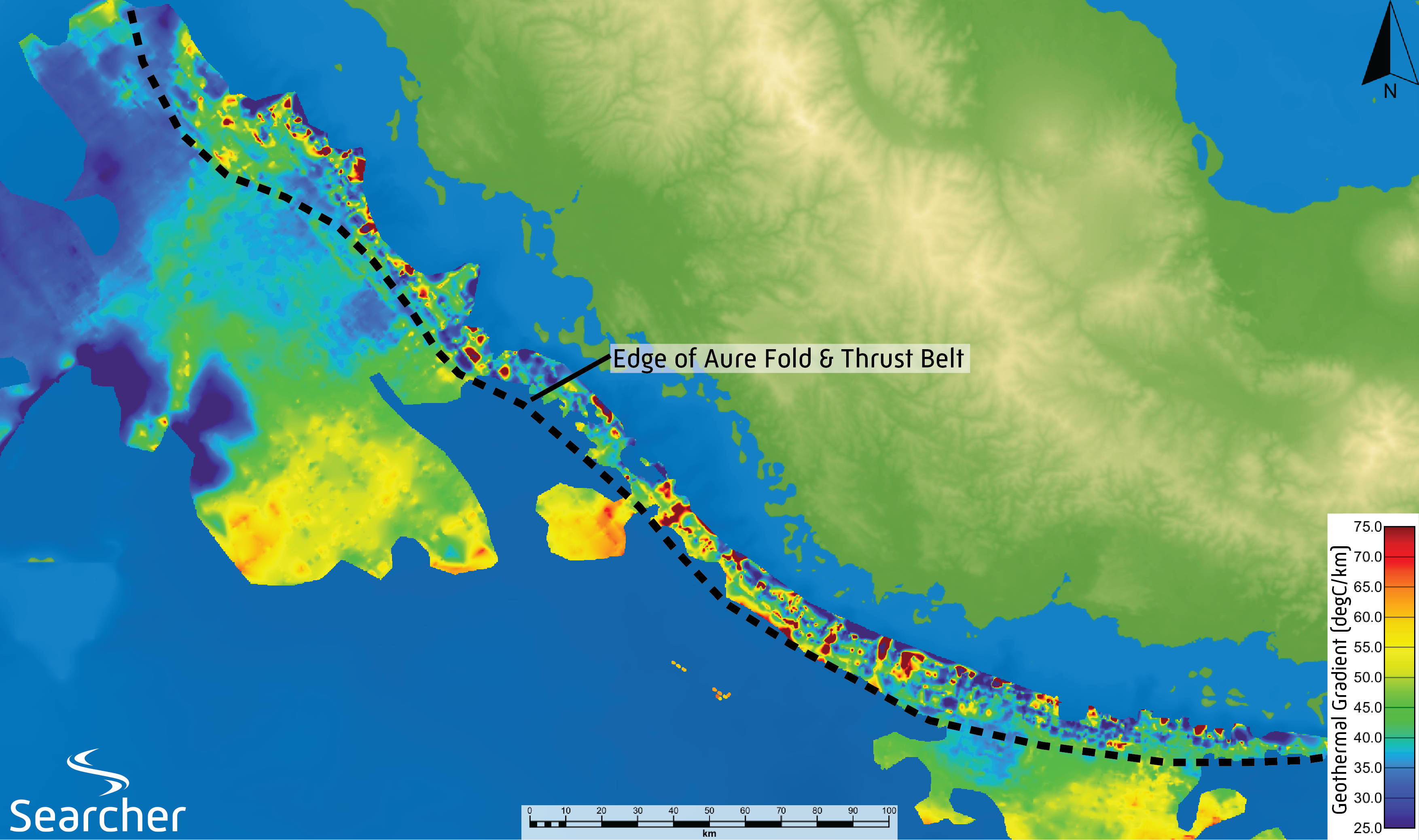
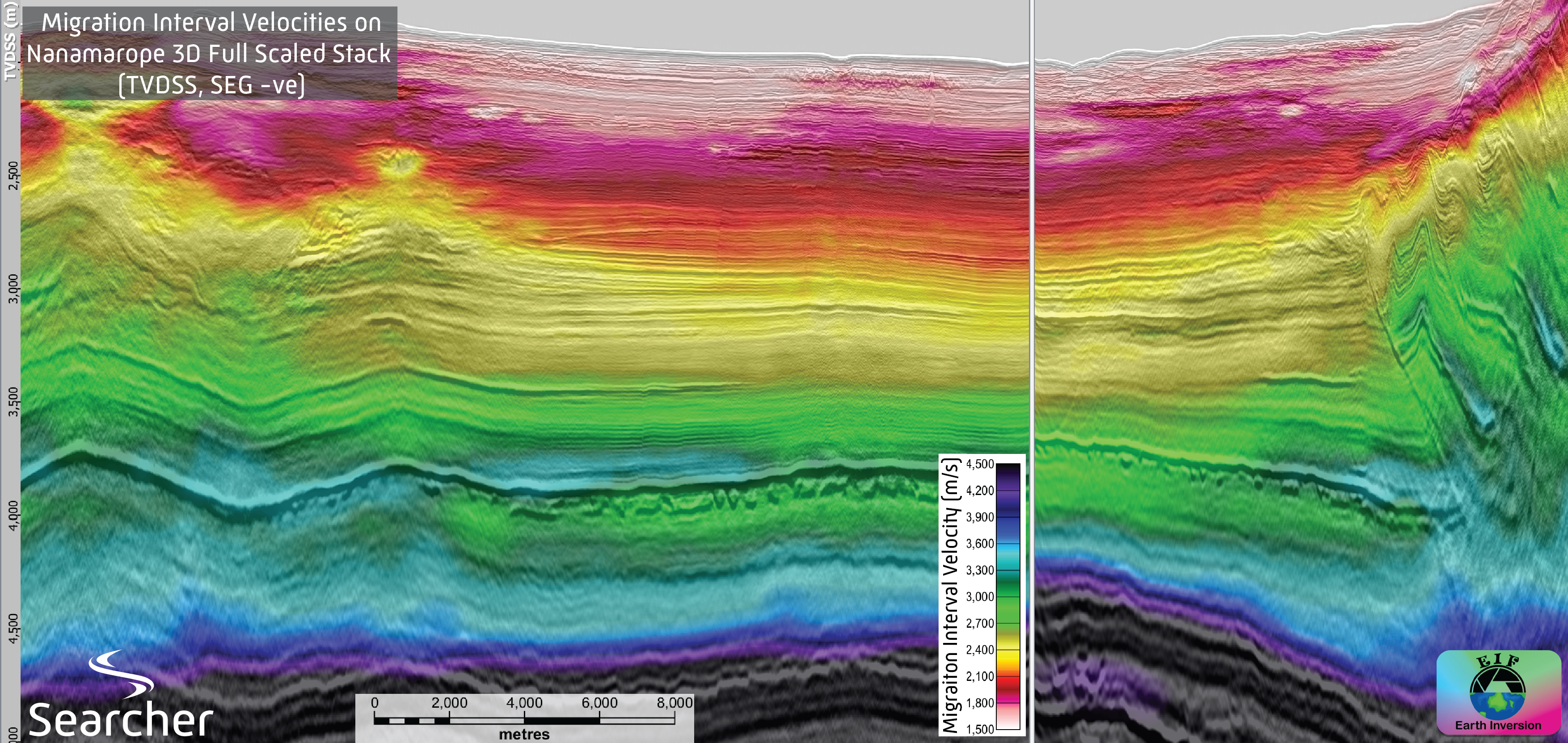
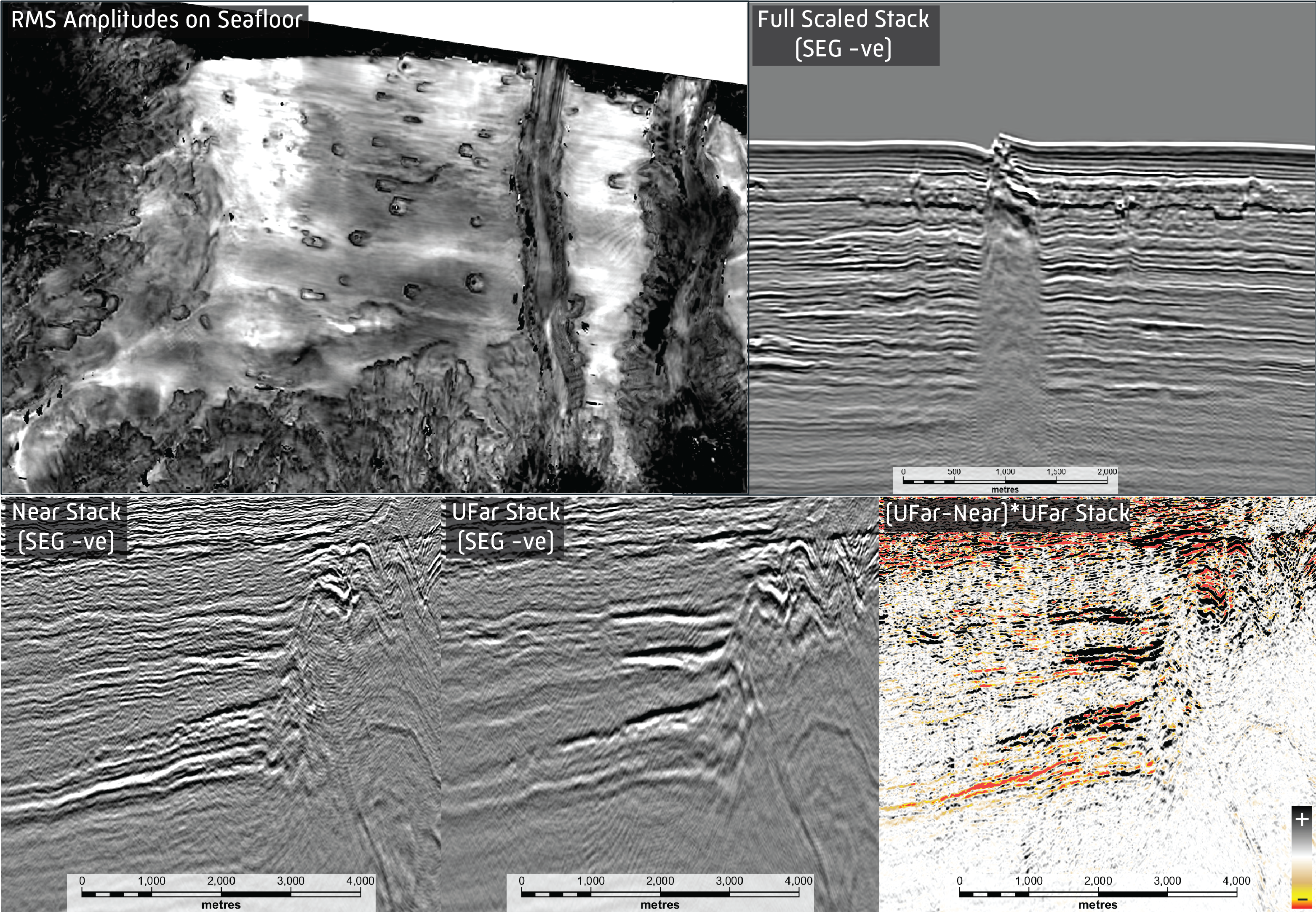
This is the story of how a basin that was previously thought of as “cold”, with only a thin veneer of Tertiary sediments deposited on top of oceanic crust, was transformed into an attenuated continental crust mode with high geothermal gradients and thick preserved sedimentary sequences. All thanks to advances in geophysical imaging technology. In combination with additional geochemical and airborne gravity gradiometry, this has allowed for the identification of a potential oil province. Now it is waiting for the first well to be drilled to test this newly defined play. A lot can change in twenty years. In 2004, the Nintendo DS had just been released, Facebook was taking its baby steps and Jennifer Saunders graced the world with one of the best covers of a pop song known to man in Shrek 2. Much like the titular character one of the highest grossing films of the year, the offshore geological story of Papua New Guinea had been holding out for a hero, which came ten years later in the form of rapidly advancing seismic acquisition and processing technologies. The Gulf of Papua, a region spanning 187,000 km2, is roughly equivalent in size to the Anglo-Dutch Basin, but has had less than thirty exploration wells drilled, and only three in the last twenty years. All drilling has been constrained to the Fly River Delta searching for gas in carbonate buildups and basin floor fans lying in shallow water (<500 m). A very sparse seismic coverage beyond the Fly River Delta (Base Map, red lines) supported the interpretation of a shallow, cold Papuan Basin, with a thin veneer of Tertiary sediments on top of oceanic crust associated with the opening of the Coral Sea in the Early Tertiary (Figure 1, B-B’). Full of imaging challenges and multiples, likely restrained by processing technologies available at the time, the seismic did not lend itself to a complex geological interpretation. This began to change in 2006, when Searcher, in partnership with Spectrum, acquired the Lahara Seismic Survey. Originally processed with a PSTM workflow, this imaged previously unseen depocentres and provided hints of preserved sedimentary sequences beneath the Coral Sea Breakup Unconformity beyond the Fly River Delta. 2014 reprocessing with a PSDM workflow, quickly followed by the acquisition of two long-offset 2D broadband surveys in 2015 and 2016 in partnership with BGP, covered the Gulf in a grid of 10×10 km to 5×5 km seismic that imaged to 35 km depth. These new seismic insights (Figure 1, C-C’ and Foldout) were one of the key tools in revolutionising interpretations of the Papuan Plateau. Rather than thin and structureless sediments overlain on oceanic crust, a complex sedimentary package exists, including thick preserved sequences below the Coral Sea Breakup Unconformity. Large horsts and grabens with internal structures have been mapped, mimicking the stratigraphy below the breakup across the inboard region, but without the thick overlying Tertiary carbonates present across the Fly River Platform. In addition to these new observations, a Moho event could be mapped across the Gulf, challenging industry held views of the crustal nature at the time. The seismic data, along with complementary Geochemcial and Airborne Gravity Gradiometry (AGG) surveys, revealed that the vast majority of the Papuan Plateau is indeed underlain by attenuated continental crust with high geothermal gradients. These are mapped on the modern seismic using bottom simulating reflectors (BSRs), which can be used as a data-led proxy for geothermal gradient in frontier basins (Figure 2). Gradients range from 30-35° C / km in the Fly River Delta to 40-50° C / km around the basement highs and within the Aure Fold & Thrust Belt (FTB). This allows the synrift and Late Cretaceous-Paleogene early post-rift sections to be hot enough to sit in the peak oil generating window, supported by observed geochemical and seep data. This new interpretation of the crustal nature and heat flow across the region allows for the extension of the prolific onshore Mesozoic plays, such as the recent discoveries at Muruk (Santos, 2016) and P’nyang (ExxonMobil, 2018). Investigations into the prospectivity and potential petroleum systems have continued across the extensive datasets, inclusive of Searcher’s 2023 acquisition of Nanamarope 3D, a survey within the Aure FTB covering a large Mesozoic depocenter. Whilst in the foredeep on the Papuan Plateau the oil source is synrift, within the fold belt, the stacking of thrust sheets matures the source rocks in duplex thrusts, just at the critical moment when huge structures are forming above them. Due to the complex nature of the geology in the area, including a canyon-ridden seafloor, several modern and high-end processing technologies, including multiple iterations of Full Waveform Inversion (FWI) and Q tomography modelling were utilised (Figure 3), resulting in the clearest insights into the complicated shallow geology and deeper depocentres to date. The high-resolution 3D data allowed for the improved interpretations of petroleum systems elements, including Direct Hydrocarbon Indicators (DHIs), where foredeep gas is trapped in very large low-risk traps against the leading thrust of the fold belt (Figure 4). With the extensive multi-disciplinary geotechnical datasets acquired and reprocessed over the last twenty years, the offshore Gulf of Papua has been transformed from a shallow and cold region to a prospective continuation of the synrift generated oil provinces so prolific in the onshore and across the basins of northern Australia. Similar to Hollywood’s favourite ogre, the Papuan Plateau’s layers have started to be peeled back through the rapid technological advances and now it awaits its next hero – a champion to drill an exploration well.
Exploration of the Papuan Plateau: How revolutionary geophysical technology reveals new seismic insights
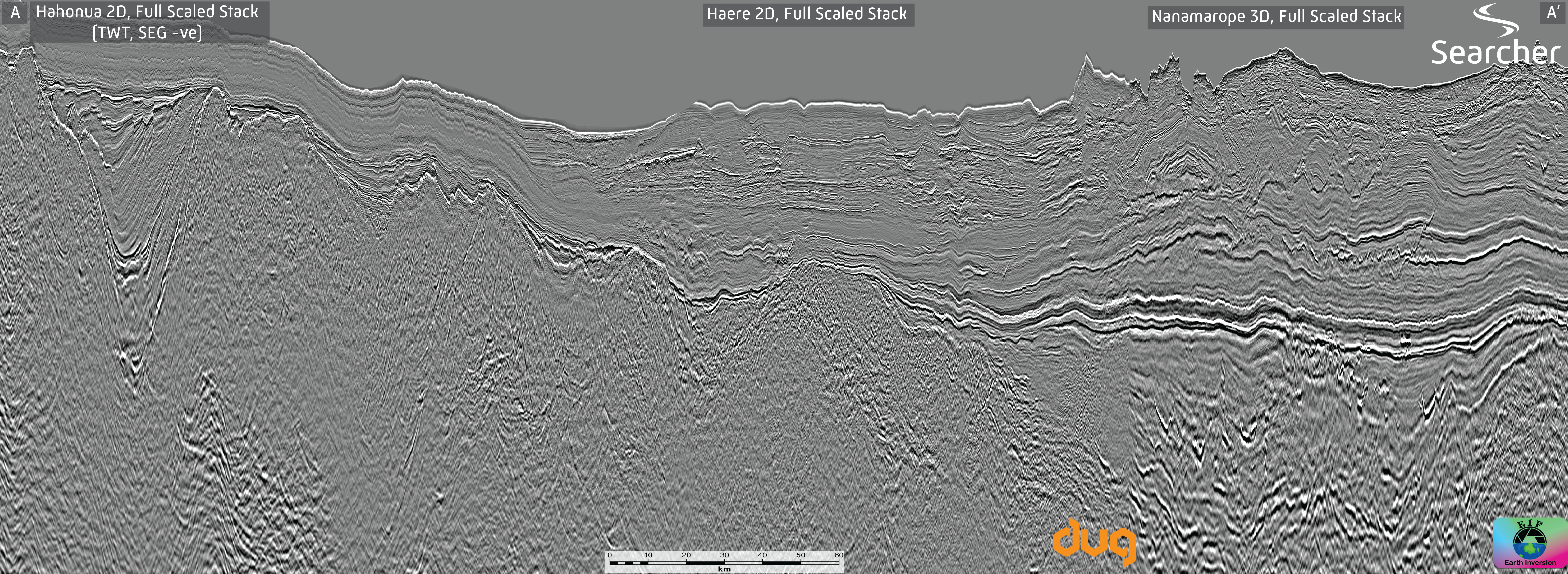 (A-A’) A 280 km arbitrary line across the Papuan Plateau and Aure Fold & Thrust Belt, highlighting deep Mesozoic depocentres preserved beneath the Early Tertiary Coral Sea breakup, and the complex imaging in the overburden.
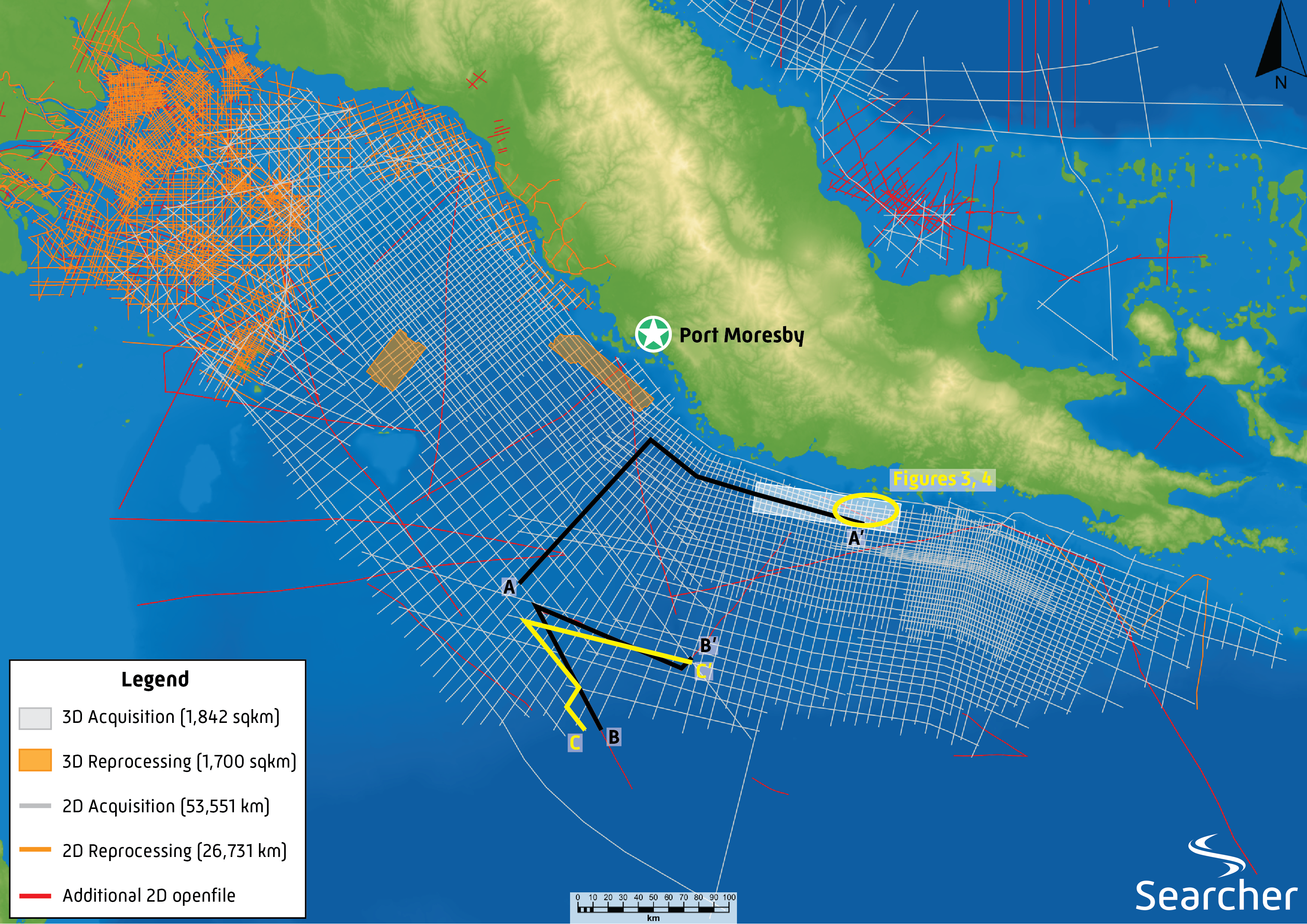
Holding out for a hero: How evolving geophysical technology revolutionised a Frontier Basin
Related Articles