Bottom-current facies; Lysing Member in well 6507/5-8, Ærfugl.
How careful core description and detailed biostratigraphic analysis can delineate sub-seismic reservoir zones in a highly mud-prone system
A multi-disciplinary, multi-well appraisal of reservoir development in the mid-Cretaceous, offshore mid-Norway
This study was undertaken by PetroStrat in collaboration with Stratum AS (QEMSCAN), Barnwell Parker Geoscience Limited (seismic interpretation) and HM Research Associates (heavy mineral provenance analysis). Together, we have completed a year-long multi-client appraisal of approximately 765 m of mid-Cretaceous core in 20 study wells across the Halten and Dønna Terraces, to quantify and map reservoir presence and reservoir quality in deep-water Aptian to Coniacian sediments.
Sand fairways were mapped within a high-resolution biostratigraphic framework, based on new analysis of 625 samples from 29 wells, refining existing NOD/Diskos-sourced paper data to generate PetroStrat ‘K-sequences’. The latter range from the late Aptian K24 sequence through 10+ Turonian K40-K58 time slices, to early, middle and late Coniacian K60, K62 and K64 sequences.
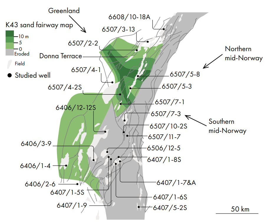
Subsidence patterns, guided by seismic interpretation commissioned for the study and isopach mapping of individual time slices, reveal the development of local depocenters and unconformities as the area extended and subsided through mid-Cretaceous times. Sand fairway provenance was constrained by heavy mineral analysis, QEMSCAN data, conventional petrographic analysis and detailed records of biostratigraphic reworking. Fairway mapping was constrained by process-based sedimentological analysis of core.
Narrow fairways
The thicknesses of clean to slightly silty sandstone within each time-slice define ‘optimal’ sand fairways, which were hand-contoured between wells, guided by seismic data. The system is sand-poor, with accumulated thicknesses of less than 10 m of ‘optimal’ sand present in any one time slice. Only five of the time slices encountered in the analysed wells contain metre-scale ‘clean’ sand accumulations. Fairways in the other time slices happen not to include ‘optimal’ sand in the analysed wells. the fairways are narrow, bounded by sea-floor highs, and are generally below seismic resolution.
Gravity-driven sands were deposited mainly within subsiding zones between active tectonic highs. These highs were generally elongated parallel to the Dønna Terrace trend (SWNE), but the influence of cross-cutting NW-SE trending lineaments (e.g., the Gleipne and Jan Mayen Fracture Zones) is evident on the isopach map of one example time slice (Figure 1). Sand provenance data suggest dominant sand supply was from Greenland at that time, with northern Norway also supplying sediment in this and other time slices. Southern mid-Norway was apparently not a common source of sediment. Biostratigraphic data record reworking of Palaeozoic to Cretaceous sediments into many of the fairways, consistent with sand supply via river systems draining areas of complex palaeo-geology.
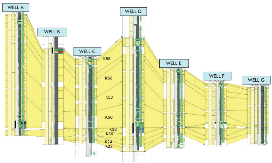
A major unconformity
Erosion of earlier Cretaceous time-slices to the south and east of the K43 fairway resulted in a major unconformity, illustrated by the correlation panel in Figure 2, separating K33 (mid-Albian) from K50 (early Turonian) sediments, with the Cenomanian Stage missing. In the Egyptian Vulture (6407/1-9) well, the highly bioturbated Albian marls are reddened below the unconformity and are overlain by softer, dark grey, weakly bioturbated shales that were deposited in a poorly circulated intra-shelf basin after the collapse of the eroded uplift.
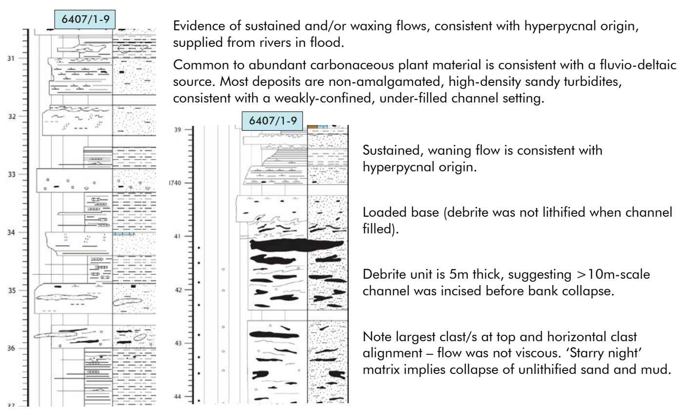
Turbidite sands overlying this hiatus accumulated in a subsiding mini-basin, within weakly confined channel systems that were supplied by hyperpycnal, sustained flows (Figure 3). Multi-metre thickness of sustained flow deposits suggests the input of large volumes of sediment in single flood events, likely from major river systems (rather than by erosion of local islands). Debrites intercalated with the turbidites comprise large clasts of weakly lithified mud and sand floating in a ‘starry night’ matrix of poorly-sorted sand and mud; these are interpreted to record bank collapse events that reworked poorly-consolidated sediment into the channels, together with remobilisation of sediments from the margins of the mini-basins shortly after their initial deposition.
The dominant turbidite sandstones are replaced locally (mainly across the Dønna Terrace) by the deposits of episodic tractional flows, loosely termed ‘contourites’ in this study (although their flow orientation is uncertain in the absence of image log data).
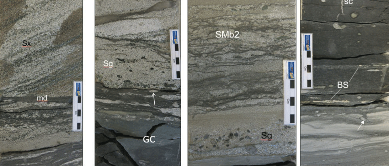
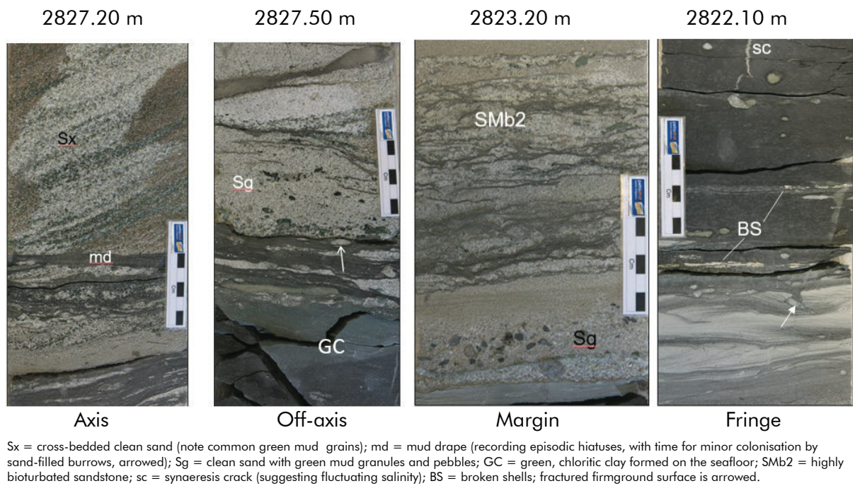
Contourite facies
Figure 4 illustrates the range of ‘contourite’ facies encountered. These sandstones can be highly permeable and are generally somewhat coarser grained and better sorted than the associated turbidites, perhaps due to winnowing of the latter on the seafloor before they were consolidated. Green, chloritic grains, granules and pebbles of mud are common in these sandstones, evidently having been reworked from seafloor muds. The latter appear to have been formed by seafloor alteration of originally grey, smectitic muds and ash-falls that were then eroded by the contour currents.
Episodic tractional flows, transporting dunes or mega-ripples of medium and coarse sand across the seafloor, were punctuated by accumulation of grey mud drapes that were then colonised by sand-filled Planolites and Sabularia burrows, together with common muddy Arenicolites and local Zoophycos. The prolonged hiatuses recorded by this colonisation suggests highly episodic contour current activity, perhaps modulated by storms or tides and focused between seafloor highs.
The reservoir quality of these sandstones is mainly a function of their grain size and grain composition, with ductile materials (mainly mica, mudstone grains and detrital clay) enhancing the impact of deep burial compaction. Post-compactional cementation is less important, particularly in shallower wells. The contourite sandstones, representing winnowed turbidite deposits, tend to be coarser grained, better sorted and less ductile-rich than their predecessor facies (although ductile mud grains can be common – as seen in Figure 4 – and are associated with later calcite cements).
The impact of thin contourite beds on the reservoir performance of the dominant turbidite systems is cryptic, since some beds are highly permeable ‘thief’ zones whereas others form pervasively-cemented baffles to fluid flow.
One driver for this study was to assess the potential impact of local erosion of clean sand from uplifted Garn Formation intervals, forming high-permeability turbidite systems (e.g. in the area around Dvalin North, Block 6507/7). The cored examples of this play type comprise multi-Darcy Lysing Member sandstones deposited on eroded Garn highs. The Lysing units (probably of mid-Coniacian, K62 age) are submarine fan-delta deposits containing large clasts of mud, coal and sand reworked from the nearby mid-Jurassic hinterland. Muddy K62 facies in the surrounding wells suggest these high-quality sands are of limited extent, probably forming small footwall turbidite systems attached to active highs. More extensive deposits can be expected in hanging-wall systems of similar age.
Delineating sub-seismic reservoir zones
This study shows how careful core description and detailed biostratigraphic analysis can delineate sub-seismic reservoir zones in a highly mudprone system. The application and integration of heavy mineral analysis, QEMSCAN data and biostratigraphic reworking signals is clearly vital to understanding the transport directions of the sand fairways, with process-based sedimentology of cored intervals indicating the types and thus geometries of the geobodies.