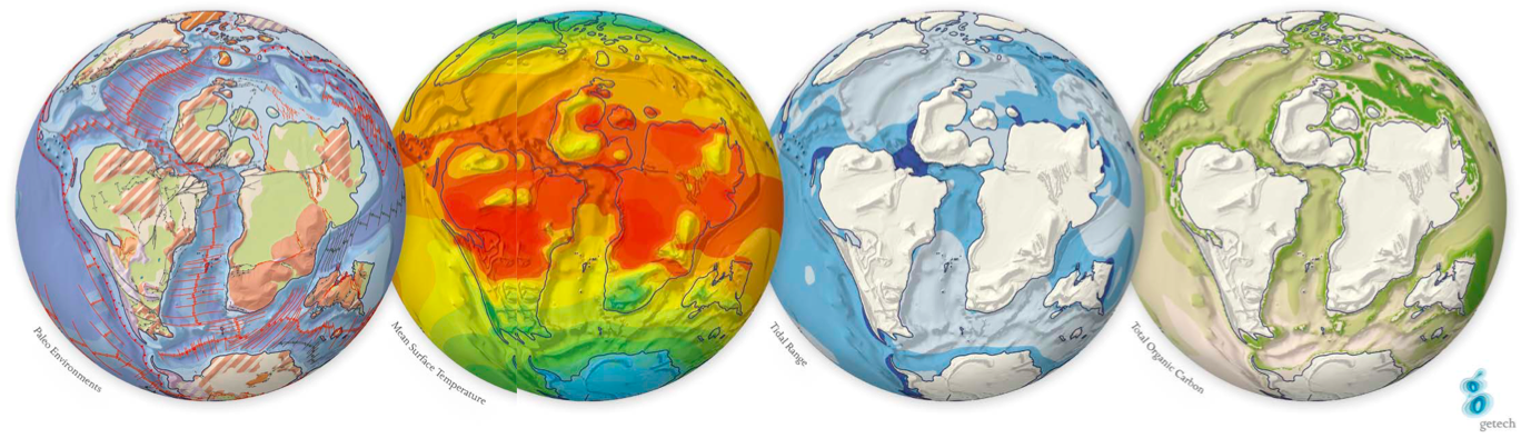
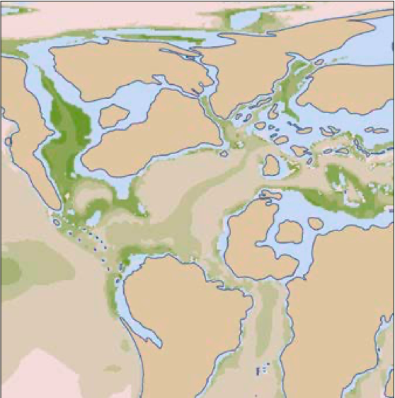
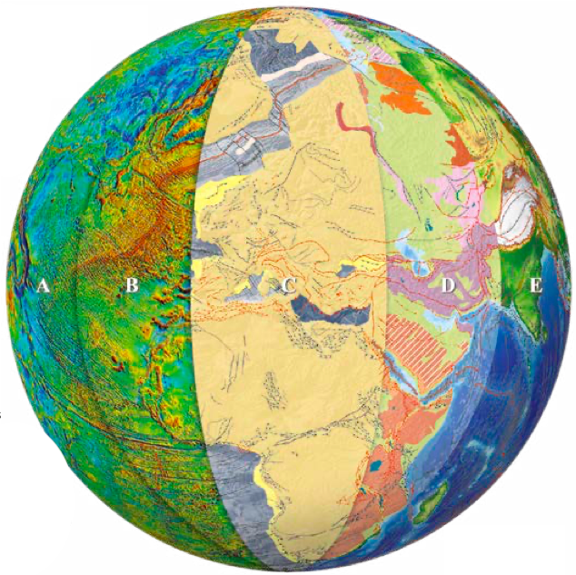
Building a portfolio of global models for all of the 59 stratigraphic stages from the Permian to Present Day requires a layered approach – from the lithosphere to the atmosphere. Getech build these state-of-the-art models from the very bottom to the top. The foundation is an understanding of the Earth’s structural framework and crustal architecture constrained from the most comprehensive collection of gravity and magnetic data available, together with remote sensing analysis, seismic and geology. These data enable Getech’s geoscientists to reconstruct the tectonic histories of each crustal element, which together define their global plate model. This model provides the globally consistent framework and set of accurate base maps on which are superimposed gross depositional environments, base-level variations, sediment source areas (uplift), transport pathways (paleo-rivers) and elevation. Conditioning these data sets with present day analogs and geological data allows detailed modeling of the evolution of landscapes through time. The paleobathymetric and paleotopographic grids resulting from this work, together with the defined paleo-river systems, provide the key boundary conditions for a coupled ocean-atmosphere climate model that is used to generate quantitative oceanographic, climatic and vegetation results. These results yield insights into the processes that affect deposition of source, reservoir and seal facies: from landscape development and sediment fluxes that determine the composition and character of clastic sediments, to the distribution of upwelling zones, ocean currents, and watermass stratification that influence organic matter production, preservation, and dilution. Paleobathymetric models also provide the necessary input for detailed, variable mesh tidal modeling which is used to reconstruct transport capacity and the probable nature of coastal bedforms. Getech’s models of lithofacies distribution are not simply based on averaging and masking of pre-defined cut-off values for selected variables; they use an quantitative approach. This defines their understanding of not only the location of reservoir and source facies, but also the variation and sensitivity of the systems themselves. This is key to being able to fully assess exploration risk in frontier areas. Building Tool-Sets for Global Exploration: Paleogeography, Paleoclimatology and Source Rocks Source rocks are a pre-requisite of any petroleum system. Whilst the deposition of a potential source rock facies does not guarantee either the presence or effectiveness of a petroleum system, it at least establishes the possibility of one. Frontier basins inevitably have little or no analytical source rock data prior to exploration, and the occurrence and quality of a source rock may be inferred only from regional or theoretical analogs. Additionally, data that are available may be unrepresentative of the facies in the potential kitchen areas, therefore extrapolation and interpolation are often required. Exploration risk is thus inevitably high; anything that can help to screen basins and thereby reduce risk is crucial. Getech’s approach to reducing source rock risk is via modeling and prediction of the initial depositional distribution of organic-rich sediments. This is based on its stage-level paleogeographic reconstructions plus, for marine facies, algorithms for parameters such as primary productivity and sedimentation rate. The paleogeographies provide inputs for atmospheric and ocean circulation modeling and tidal modeling, which in turn assist with lithofacies prediction, including some parameters directly relevant to source rock development. These include paleoclimate, runoff, clastic sediment flux, upwelling, ocean circulation or stratification, oxygen solubility, oxygen demand, tidal bed shear stress, and tidal mixing regimes. Modeling of organic matter input, preservation and dilution allows both qualitative and quantitative predictions of source rock occurrence and properties. In particular, it is possible to predict initial total organic carbon (TOC) and kerogen type, both fundamental inputs for basin modeling. As in most things, the truth is more commonly grey rather than black or white, so Getech’s quantitative models are designed to permit an assessment of degrees of source rock potential. As the paleogeographic reconstructions underpin the whole modeling exercise, it is appropriate to briefly review the Globe workflow on which they are based. Mapping of the present day distribution of geological structures is based on our comprehensive global gravity and magnetic data library (Layers A and B on image on page 84) coupled with other data. Each structure is classified and fully attributed with information on its nature and activation history. This, in turn, helps constrain the plate model (Layer C). Plate rotations and hierarchies are synthesized from an analysis of diverse datasets, including Euler poles, paleomagnetism, relative plate motions, fossil distributions, orogenic histories, basement ages and accretion timings. The initial global plate model forms the fundamental crustal framework evolving through ongoing, focused testing and modeling of regional crustal classification and composition. The base maps created from the plate model include rotated cultural and structural data, plate polygons, and all compiled constraint data. The key paradigm that underpins the mapping of Getech’s paleogeographic reconstructions is the use of a contemporary base-level to distinguish between depositional ‘sink’ areas below baselevel, and tectonophysiographically defined sediment ‘source’ terranes above base-level (Layer D). Sediment facies and lithology are compiled and mapped within the sinks. The paleogeographies also enable analysis of drainage networks: for younger timeslices this can be informed by a careful analysis of modern day drainage and topography, while for older timeslices, provenance analysis is used to infer the source to sink relationships. Digital elevation models (DEMs) of paleotopography are created using the prevailing tectonic conditions, modern day analogs and an understanding of surface processes (Layer E). All these steps are iterative with feedback loops driving continuing refinement and improvement. In compiling paleogeographies, it is important to take account of sea-level variations throughout the stage being mapped. Whilst marine reservoir facies are most likely to be deposited during low-stand, marine source rock facies will tend to be deposited during transgressive phases. Defining the coastline for highest stand for each timeslice thus allows us to utilize the most appropriate bathymetry as an input to our models. Additionally, organic rich, oilprone sediments occupy a broad environmental envelope in terms of water depth, paleoclimate and lithology; there is no single combination of factors which results in their development. In different regimes, high input (productivity), enhanced preservation (dysoxia-anoxia), or low dilution may be the predominant factor explaining organic-richness. Getech’s initial focus has been mainly on marine shelf and slope source rocks where the prevalent pattern appears to be one of enhanced preservation coupled with low dilution in deeper, distal and low energy facies. By changing the assumptions and algorithms used in the source rock models, it is possible to test different scenarios and hypotheses and thereby appraise the relative or absolute impact of different parameters on the modeled outcomes. Predictive success can be improved when real data is available and can be substituted for modeled inputs. Monte Carlo modeling can then be used to address levels of uncertainty at a more local level. As the late statistician George Box observed, ‘All models are wrong, but some are useful.’ Modeling is necessarily an iterative process and initial models must always be refined in order to produce a convergence between predictions and observations. Algorithms based on modern data analogs provide an initial ‘blind test’ prediction, resulting in a quantitative approach that is independent of actual source rock observations. Such models, utilizing mean productivity, water depth, distance from land, and latitude, can predict much of the global scale pattern of organic-rich sediment distribution, and an even closer fit with observations is possible when upwelling and dysoxia-anoxia are taken into account. A quantitative approach built on carefully compiled and interpreted data via the Globe workflow means that consistent, objective predictions of global source rock distribution become an accessible goal. By utilizing Getech’s predictive paleolithofacies modeling to understand how source rock distribution and quality are influenced by paleolandscape/ bathymetry and paleoclimate (and the influence of the underlying plate tectonics), explorationists can better evaluate the risks associated with the source rock component of the petroleum systems in frontier areas.
Around the world in 59 Stages
Reducing exploration risk through modeling
Fueled by data
Refining the models
Applications for exploration
Related Articles


