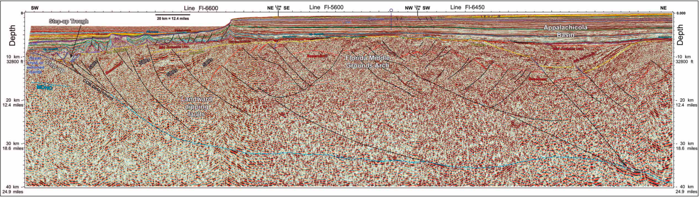
Long-offset seismic reflection data over the western Florida shelf and eastern Gulf of Mexico provide new insights into local geology, illuminate new exploration plays and increase understanding of rift models worldwide. The FloridaSPANTM seismic survey extends ION’s existing mega-regional Gulf of Mexico (GoM) dataset to include the important rift history and exploration potential in the offshore Florida margin. Long-offset seismic reflection data (10 km streamer, depth imaged to 40 km, deep-tow acquisition) over the western Florida shelf and slope provide new insights for the local geology and add to the inventory of exploration plays. Key results include a more complete understanding of the crustal architecture of the GoM basin and rift models around the world. A great value of ‘SPAN’ data is the superb resolution of crustal-depth structures and the deep sedimentary section. The crustal images constrain the rifting process as well as the Mesozoic tectonic evolution of the Gulf of Mexico. The deep-tow seismic acquisition technique allows strata to be imaged with unprecedented detail in carbonate shelf areas where seismic reflection multiples and paleo-karst challenge seismic imaging. At the basement level, two contrasting structural and early depositional provinces comprise the ‘outer continental margin’, which lies outboard of the present-day shelf edge and inboard of the deep GoM’s oceanic crust (Figure 1). The northern province (Florida Middle Grounds region) is characterized by three main features: landward dipping listric basement faults; fault-bounded packages of seaward-dipping reflectors that appear to be at least partly volcanic; and a fairly smooth, planar sub-salt or ‘break-up’ unconformity overlain by deformed sections of Louann Salt. This surface tilts basinward to structural levels as deep as the adjacent oceanic crust (Figure 2). In contrast, the southern province comprises seaward dipping basement faults, no clear sign of volcanics, and little mobile salt (Figure 3). A regional break-up (i.e., ‘end of basement faulting’) unconformity occurs at a higher stratal level than the one in the northern province. As in the north, this unconformity also dips basinward to structural levels as deep as the adjacent oceanic crust. Upon close inspection, this unconformity overlies an older unconformable surface that is faulted up to the time of the younger unconformity. The older surface may be related to the sub-salt unconformity in the northern province. The existence of two unconformities in the south is predicted by regional models (e.g., Pindell and Kennan, 2009) that call for two stages of GoM evolution. The older one probably relates to intracontinental stretching across the entire region (~Early Oxfordian culmination), and the younger to the end of rotational seafloor spreading that is expressed in the southern province as rift propagation between north-east Yucatán and west ern Florida (Early Cretaceous, well after GoM salt deposition). The two basement provinces also share some common aspects. Both terminate basinward in a structural depression where the rifted margin transitions into the structurally higher oceanic domain of the deep GoM. This rise to the top of the oceanic crust has been termed the ‘basement step-up’ (Pindell, 2002; Pindell and Kennan, 2007) and the basement depression the ‘step-up trough’. The step-up trough can be 30 to 50 km wide and coincides closely with the eastern GoM’s gravity low outboard of the shelf edge (Figure 1). Secondly, both provinces show a deep landwarddipping (often about 20°) surface that appears to connect the step-up trough with the continental Moho beneath the Florida shelf edge. One could refer to this surface as the Moho beneath the thinned crust of the outer continental margin. We assign a second tectonic significance to this structure, namely that it is a lithospheric scale, low-angle, extensional detachment shear zone that effectively defines the continent-ocean transition. Figure 4 highlights the key aspects of the southern province that we believe pertain to the continental break-up process. We believe normal movement on this surface is responsible for the rapid collapse and basinward tilting of the outer margin at tectonic subsidence rates at the time of the rift to drift transition (Pindell et al., 2011). The presence of SDRs and landward dipping faults beneath the sub-salt (breakup) unconformity in the north makes it tempting to consider the Middle Grounds region as a volcanic margin (e.g., Imbert and Philippe, 2005), with implications for the northern GoM margin. However, if the half grabens and volcanic fill are of Central Atlantic Magmatic Province age (200 Ma) rather than Middle Jurassic, then the magmatism would predate the onset of seafloor spreading in the GoM by some 35 Ma, and the two would not be genetically related. Here, we acknowledge the volcanic nature in the north on geometrical grounds only and disregard the age and genetic causes of the inferred magmatism. Using the two-stage rift model as a foundation of basin evolution, the syn-rift and early post-rift history of the western Florida margin created complex regional geology with distinct differences between the northern and southern areas. The Middle to Upper Jurassic isopach map (Figure 5) shows a series of depositional thicks related to rifting and subsequent subsidence in the Destin Dome area. Depositional thins demonstrate stratigraphic pinchout onto paleotopographic highs, and changes in isopach thickness also correlate with salt withdrawal in the area. The structural troughs (e.g. Appalachicola, Sarasota) and highs (e.g., Middle Grounds, Sarasota arches) are inherited from early rifting (Stage 1). Middle and Late Jurassic sediments progressively onlap the early shelf to the south and are absent on the broad Sarasota Arch area. Early sediments are also missing at the break-up unconformity that surrounds the Destin or Appalachicola Basin. As the Florida Escarpment was built up and became a barrier, the sediment accumulations were greatest outboard of the building margin. Several new play ideas are identified on the northern GoM margin. However, if the half grabens and volcanic fill are of Central Atlantic Magmatic Province age (200 Ma) rather than Middle Jurassic, then the magmatism would predate the onset of seafloor spreading in the GoM by some 35 Ma, and the two would not be genetically related. Here, we acknowledge the volcanic nature in the north on geometrical grounds only and disregard the age and genetic causes of the inferred magmatism. New Exploration Plays Using the two-stage rift model as a foundation of basin evolution, the syn-rift and early post-rift history of the western Florida margin created complex regional geology with distinct differences between the northern and southern areas. The Middle to Upper Jurassic isopach map (Figure 5) shows a series of depositional thicks related to rifting and subsequent subsidence in the Destin Dome area. Depositional thins demonstrate stratigraphic pinchout onto paleotopographic highs, and changes in isopach thickness also correlate with salt withdrawal in the area. The structural troughs (e.g. Appalachicola, Sarasota) and highs (e.g., Middle Grounds, Sarasota arches) are inherited from early rifting (Stage 1). Middle and Late Jurassic sediments progressively onlap the early shelf to the south and are absent on the broad Sarasota Arch area. Early sediments are also missing at the break-up unconformity that surrounds the Destin or Appalachicola Basin. As the Florida Escarpment was built up and became a barrier, the sediment accumulations were greatest outboard of the building margin. Several new play ideas are identified on the FloridaSPAN data. One example is a widespread Norphlet ‘pinchout’ play and it is delineated at several positions in the offshore Florida margin (Figure 6). The Middle Grounds Arch suggests four-way dip closure where Norphlet sand stone and Smackover carbonate build ups on lap onto this basement feature. The Smackover is defined by clinoforms that downlap onto the top Norphlet. Toplap seismic geometries define the top of the Smackover sequence. These units are posi tioned in the focus area for migrating hydro carbons from the adjacent basins with a maturing Smackover source kitchen. The long offset, deep-tow seismic data and advanced processing techniques have enhanced the imaging of these units as well as those below and above the break-up unconformities. With the improved image at depth a better understanding of the processes and geometries related to the basin evolution can help de-risk future hydrocarbon exploration plays worldwide. Imbert, P., and Philippe, Y., 2005, The Mesozoic opening of the Gulf of Mexico, Part 2: Integrating seismic and magnetic data into a general opening model. GCSSEPM Foundation 25th Annual Bob F. Perkins Research Conference, p. 1151-1189. Pindell, J., 2002, How deep was the Late Jurassic Gulf of Mexico?, Offshore Magazine, v. 62 (Feb 2002), p. 60, 62, 63, 100. Pindell, J., and Kennan, L., 2009, Tectonic evolution of the Gulf of Mexico, Caribbean and northern South America in the mantle reference frame: an update. In: James, K. H., Lorente, M. A. and Pindell, J. (eds.), The Origin and Evolution of the Caribbean Plate. Geological Society, London, Special Publications, v. 328, p. 1-54. Pindell, J., Heyn, T., and Horn, B.W., 2011, Rapid outer margin subsidence during the rift-drift transition in the eastern Gulf of Mexico: Implications for detachment faulting at continent-ocean boundaries during rifting, GCAGS Transactions, Veracruz, Mexico.
Western Florida: A new exploration frontier in the US Gulf of Mexico
A new perspective on rifting
Unprecedented detail revealed
New exploration plays
References
Related Articles


