The sequel: The hunt for Buzzard II continues
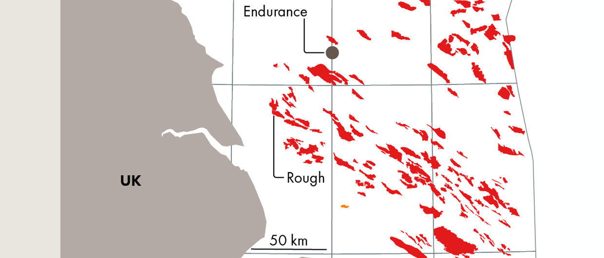
In a recent GEO EXPRO article, Neil Hodgson, Lauren Found and Karyna Rodriquez from Searcher described how the re-processing of overlapping 3D seismic surveys revealed an exciting ‘Buzzard’ age sand fairway in proximity to the Buzzard Field, UK North Sea. Within this new fairway, Finder Energy have identified a large (mean 150MMboe recoverable) prospect called ‘Whitsun’.
The prospect is located in the Peterhead Graben, a sub-basin in the geographically more extensive ‘South Halibut Basin’, home to numerous Upper Jurassic fields and discoveries of which the giant Buzzard Field, located just 15 km to the northwest remains the largest discovery to date. The field has already produced >800 MMboe and is expected to continue production post-2040.
See also: The Big Buzz of Buzzard II
So how could a prospect of this size in such proximity to a giant like Buzzard have evaded the drill bit for so long? Given it has now been over twenty years since well 20/6-3 struck pay at Buzzard, some will feel that given the sub-basin has been tested by nine wells to date, yielding only one undeveloped oil discovery (well 20/8-2), it must lack the critical elements necessary to form a functioning petroleum system. The problem with such preconceptions is that they are often formed on the back of outdated ideas.
Exploration history in the Peterhead Graben
The Peterhead Graben has undergone two phases of exploration. The first, in the early 1980s, saw five wells drilled to target hydrocarbons in the lateral equivalents of the prospective Ettrick and Piper sandstones. Rather ironically, given their conceived ‘risky’ nature, the 20/8-2 discovery well was the only well of these five to target a stratigraphic trap and the only well to find pay (8.5m net pay and an ODT in Buzzard sandstones). Subsequent geochemical analysis of the oil has shown it to be expelled from an early mature source rock and most likely sourced from the Peterhead Graben. The remaining four wells drilled on structures failed to find any significant Upper Jurassic reservoir, although three of them did find poorly developed stringers or tight sands with occasional oil shows.
Three wells were subsequently drilled between 2003 and 2004. All wells were intended to test stratigraphic traps with Upper Jurassic turbidite reservoirs, analogous to the then recently made Buzzard discovery. Only one well encountered well-developed sandstones, now known to be shallow marine shoreface sands, disproving the geological model at the time of drilling. The other two wells only encountered thin, poorly developed sandstone stringers now interpreted by Finder to represent deepwater channel levee deposits. Oil shows were seen in some of these sands, again providing evidence of an active kitchen. These thin sands provide the ‘plumbing’ to connect the thick and oil-mature pods of Kimmeridge Clay source rock in the depocenters to the sweet spots of the Buzzard deepwater sand fairway.
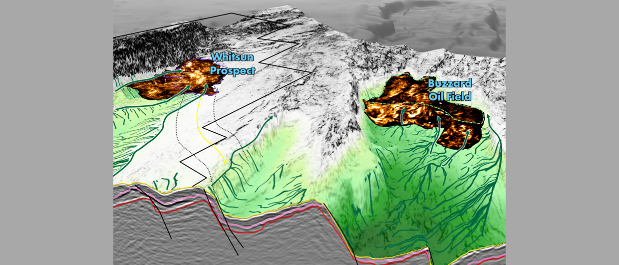
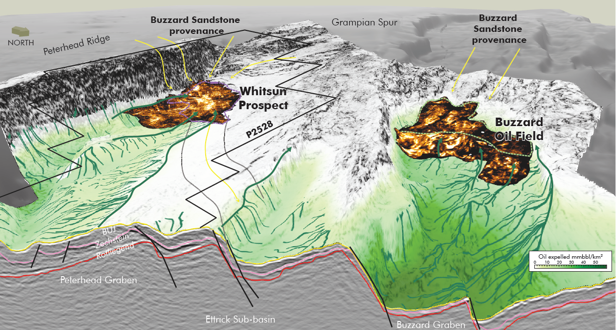
Recent mapping done by Finder on the latest reprocessing of the vintage 3D seismic data has identified what appears to be a deepwater Buzzard channel downdip of the failed 20/11-1 exploration well. It is this channel feature that provides the reservoir for the Whitsun prospect (Figure 1).
The Whitsun Prospect
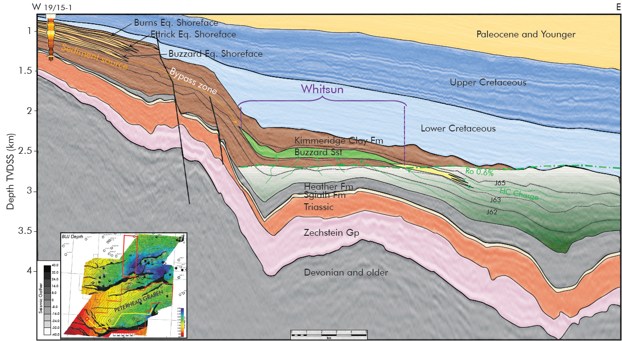
The Whitsun prospect is a Buzzard sandstone stratigraphic trap located on the western edge of the Peterhead Graben. The reservoir is mapped within the J64 interval and is trapped by dip closure to the east, pinchout to the north and west supported by mapping and proximal wells and down-thrown fault bound /pinchout out to the south. The reservoir is thought to be excellent quality Buzzard deep-water mass flow sands sourced from the Scottish Mainland and transported eastward into the Peterhead Graben. The prospect is sourced and sealed by the Upper Jurassic Kimmeridge Clay deep marine shales. Due to the prospect’s aerial extent and mapped gross reservoir thickness, Whitsun has a material resource potential of up to 770 MMbbl STOIIP (P10).
Understanding the regional reservoir story
In a sub-basin with the majority of wells encountering hints of mass flow sands and a more developed reservoir interval in the 20/8-2 well, reservoir presence was a key element to fully understand. New geological studies were undertaken, including gross depositional environment mapping and developing geological models. The study was carried out by Merlin Energy Resources, and was complemented by regional mapping on the newly reprocessed “Big Buzz” seismic data.
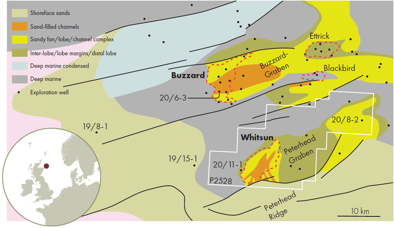
In core data, the Buzzard sands show excellent reservoir quality within mass flow sand channel complex facies and are textually mature indicating recycling in a shallow marine shelfal area (19/8-1 and 19/15-1). Within the Peterhead Graben, thin non-reservoir sands are encountered within the mainly shale-dominated Buzzard and Ettrick intervals. It is thought that these sands could indicate the outer extremities of the main Buzzard mass flow sand fairway within the Peterhead Graben.
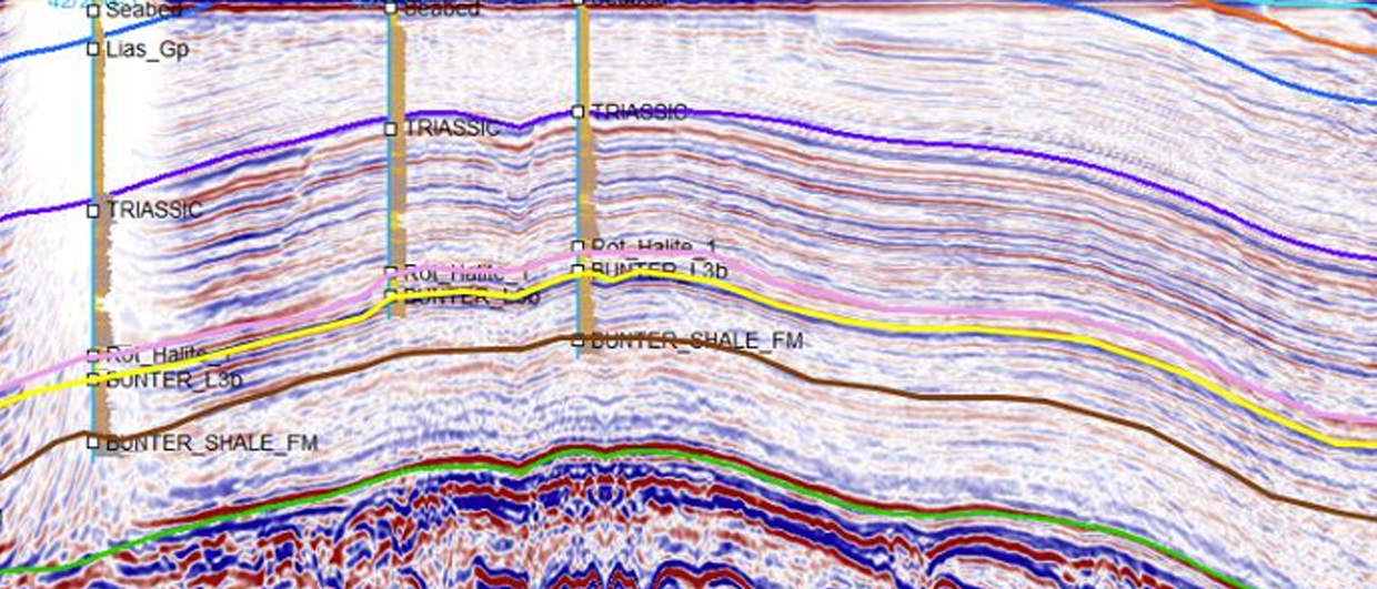
Combining the biostratigraphic analysis along with the newly reprocessed Big Buzz data allowed the Upper Jurassic to be broken down into age-equivalent intervals, enabling detailed and confident geophysical attribute analysis. Within the Buzzard interval in the Peterhead Graben, a clear seismic amplitude anomaly is seen as an elongate SW-NE trending feature comprised of thinner multiple channels feeding into a wider channel complex (Figure 1). The seismic amplitudes are consistent with geological model and explain how the previous wells missed the main sand fairway.
Peterhead Graben maturity and charge
Although proven in the 20/8-2 discovery, and with the presence of oil shows in surrounding wells, charge and migration was another key area of focus in the Peterhead Graben. This was due to the depth of the very top of the Kimmeridge Clay being immature in some areas of the sub-basin. Finder Energy contracted APT to further understand the charge potential of the sub-basin.
The Peterhead Graben contains a very thick gross Kimmeridge Clay interval. However, not all of this sequence will be source rock that is able to charge the Whitsun reservoir. A source rock and charge model was constructed assuming a net effective source rock thickness based on offset well data, which is significantly less than the mapped gross Kimmeridge Clay Formation isopach. Additionally, the present-day depth of this source interval was varied. The image in Figure 1 shows the oil expulsion yield from this net source interval modelled along a horizon that is on average a little over one hundred meters below the Base Whitsun reservoir interval. The charge mechanism into Whitsun involves short distance of vertical migration from the source rocks into the overlying J64 sands, followed by relatively short distance lateral migration up-dip into the Whitsun reservoirs (Figure 3).
A detailed charge model using traditional fetch cell and advanced Spider 3D migration and Monte Carlo calculations was calibrated to wells, fields and oils in the area. In the Peterhead Graben, the model shows the shallower Kimmeridge Clay units (above Whitsun) are marginally mature as expected. However, the thick Jurassic J56-J63 interval (directly below Whitsun reservoir) is shown to have good maturity and source rock potential in wells. This combination results in the expelled oil likely to be low maturity/GOR (<200scf/bbl).
Some uncertainty exists with fetch cell extent and migration pathways due to limited well intersections in the source rock kitchen, nevertheless the model shows the Peterhead Graben source kitchen provides sufficient generation and expulsion to fill the Whitsun Prospect.
Drill-ready
Robust technical work carried out on all the key elements and insights from newly reprocessed seismic data has uncovered strong technical evidence to support the viability of the Whitsun prospect which has now been derisked to a drill-ready status. Due to a simple well design and a shallow target depth, only a relatively cheap exploration well is required to test this high material size prospect with local infrastructure nearby. Finder is searching for a like-minded partner to join in testing this exciting prospect with the drill bit.