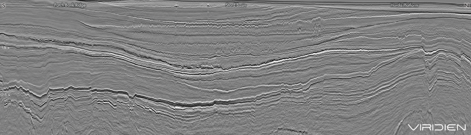
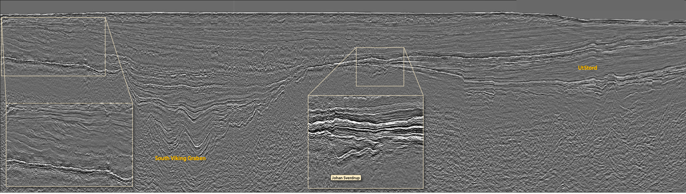
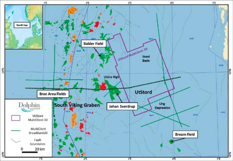
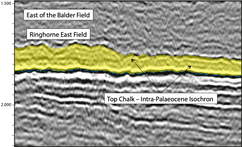
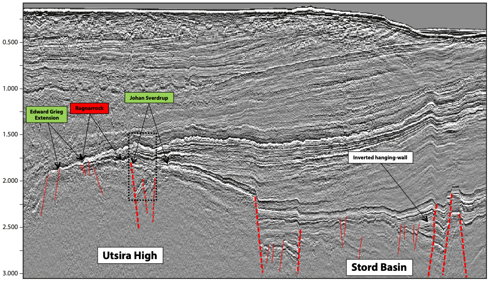
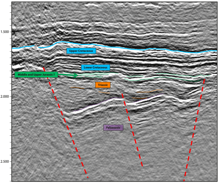
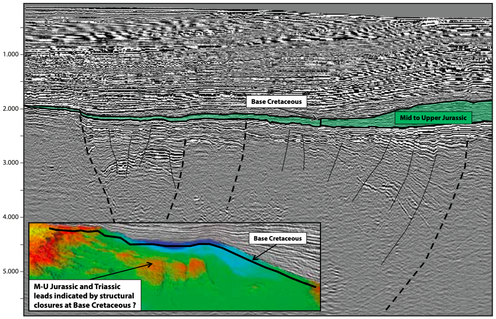
3D seismic and SHarp Broadband 2D from the UtStord and South Viking Graben areas of the UK-Norwegian North Sea show improved imaging throughout the entire geological section. In 2013 Dolphin Geophysical’s MV Polar Duchess acquired a multi-client 3D seismic survey in the UtStord area of the Norwegian North Sea, covering 5,080 km2. Also in 2013, Dolphin Geophysical’s MV Artemis Atlantic acquired a multi-client 2D SHarp Broadband survey covering 1,050 km in total, extending across both UK and Norwegian waters over the UtStord and South Viking Graben areas. The 3D seismic survey extends over three main structural elements, namely the Utsira High, the southern part of the Stord Basin, and the northern part of the Ling Depression. The 2D SHarp Broadband seismic lines tie to key wells in the 3D area, extend across the Johan Sverdrup region, and link with a series of discoveries extending across both the UK and Norwegian sectors of the North Sea. The east–west regional coverage extends from the Brae area fields, which were discovered in the 1970s and started production in the 1980s, to the relatively recently discovered fields, such as Johan Sverdrup, situated in the Utsira High area. Examples demonstrate the tectonic styles and potential of the UtStord and South Viking Graben areas. To the east of the Utsira High lies the Stord Basin, which was formed by multiple phases of extension which began in the Triassic, and continued with further pulses of extension during the Middle and Upper Jurassic. The faults are steeply dipping and planar in the shallower parts of the basin, but exhibit clear listric geometries at depth. Some of the faults have been reactivated in the Early Tertiary, which led to structural inversion geometries, such as hanging-wall folds, following the trends of these reactivated faults. The Ling Depression lies to the south and east of the Utsira High, and the tectonics in this area indicate that rifting in the Carboniferous(?)-Permian has been overprinted by later Triassic-Jurassic rifting. The structuring in the area is a result of the interaction of multiple rifting events, salt withdrawal and subsidence. To show the different tectonic styles across the area a series of selected seismic lines are displayed and discussed in this article. Figure 1 shows a sample of the Dolphin Geophysical 3D seismic at the Top Chalk-Palaeocene level. The isochron of the Top Chalk-Intra-Palaeocene is highlighted in yellow. The isochron is almost twice the thickness where the seismic crosses the Ringhorne East discovery, reflecting the differential compaction associated with the Palaeocene where sand, which forms the reservoir, is present and where it is absent. The good imaging of the Top Chalk and Early Palaeocene means that channel geometries can be quickly highlighted by combining auto-tracked isochrons and draped amplitudes throughout the whole 3D volume. Figure 2 shows a sample of the UtStord 2D SHarp Broadband, which extends from the Utsira High and part way across the Stord Basin. The left-hand side of the section crosses through the Edward Grieg extension, the Ragnarrock, and the Johan Sverdrup fields. Even at the regional scale the data clarity allows detailed fault-mapping at all levels within the section. The role of Early Tertiary tectonics and associated structural inversion is clearly indicated by the inverted hanging-wall geometries across the Stord Basin. Figure 3 shows an enlarged view of the fault linkage underlying the Johan Sverdrup field, and also seismic geometries (in green) of the perceived Mid to Upper Jurassic part of the section, which form the main hydrocarbon-bearing strata in the area. An east–west crossline from the 3D multi-client seismic is shown in Figure 4, with the Mid-Upper Jurassic intervals highlighted in green. Inset is a section of the Base Cretaceous TWT structure map, which shows fault-bounded closures (highlighted red) at the Base Cretaceous level. These are significant undrilled structures in the Utsira High area updip from the Stord Basin and Ling Depression. The main processing challenge with both the 2D and 3D data was the quite apparent presence of multiple content. Two passes of 2D SRME and Radon Demultiple generally worked well within these sections, and there was little evidence of residual water bottom or surface multiples. The aim of the processing first of all was to improve on the fault definition, especially in areas of inverted hanging- walls, and to increase signal to noise ratio plus resolution within the main section. In general, the data is coherent, appropriately scaled and clean. Another main objective of the processing is to apply an AVO-friendly receiver side deghosting (also known commercially as SHarp deghosting), run pre-stack. We believe that this has been achieved alongside all benefits of SHarp deghosting, which includes greater bandwidth recovery and sharper, deghosted images of the final stacked lines. Ian T. Edwards, Vice President, Global Multi-Client Surveys & New Ventures. Email: ian.edwards@dolphingeo.com. Mobile: +44 (0)7920 713587
3D Seismic and SHarp Broadband 2D UtStord and South Viking Graben
Improved imaging throughout
Geological overview
Processing challenges
For further information please contact:
Related Articles