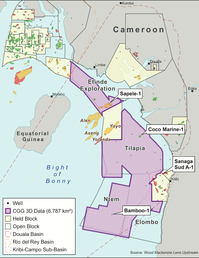
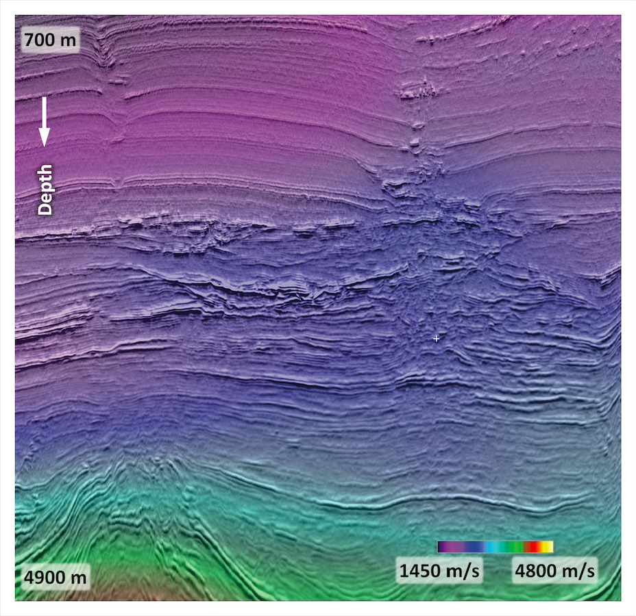
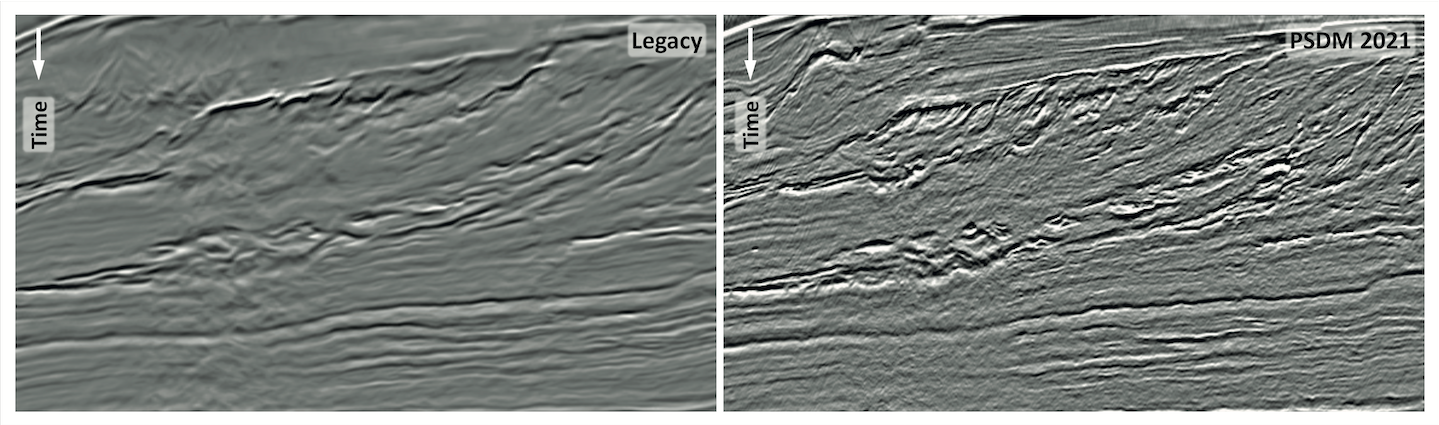
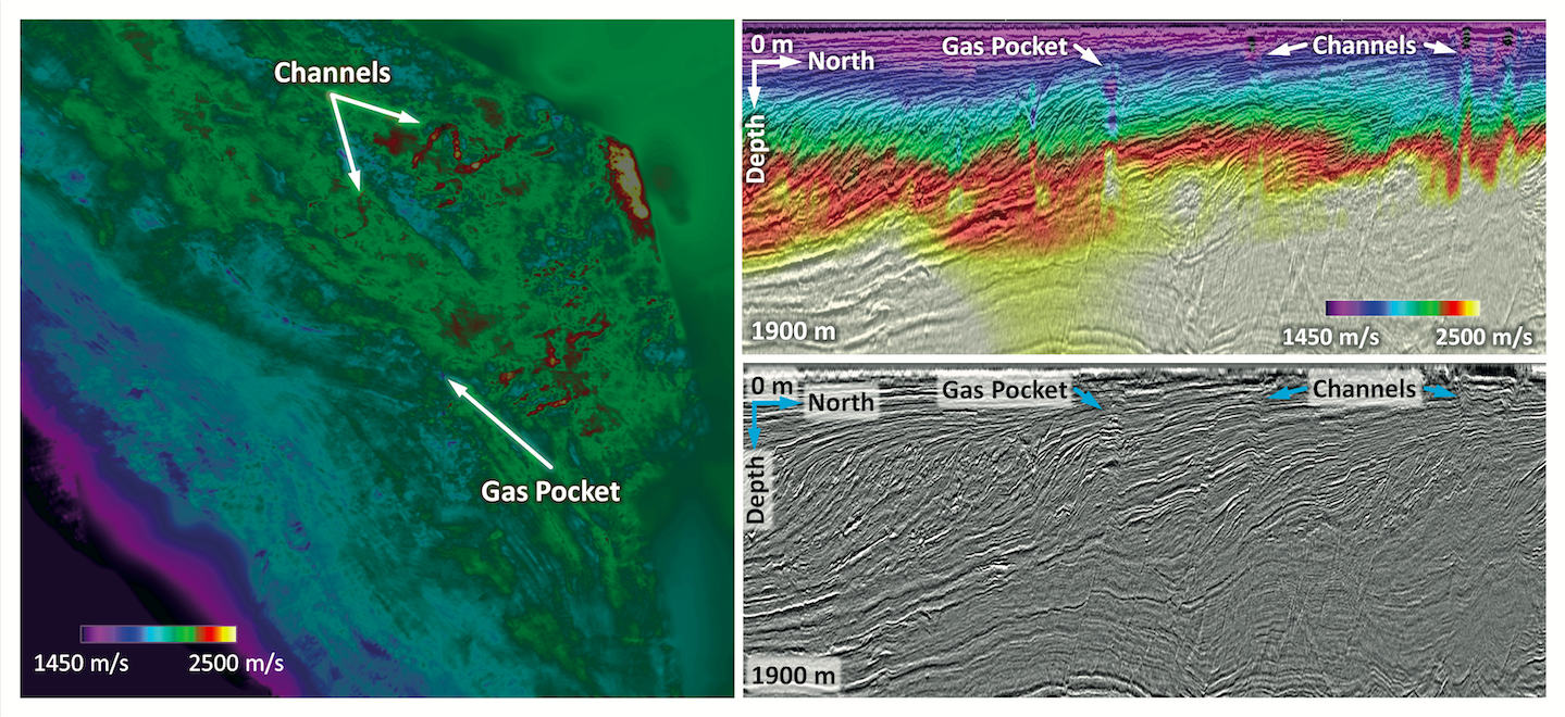
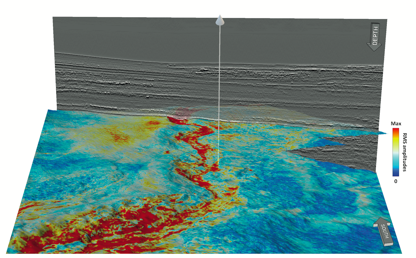
Offshore Cameroon is a proven petroleum province with commercial production from the Douala Kribi-Campo Basin (DKC) and the prolific Rio del Rey Basin (RDR). The recent joint cooperation agreement between Cameroon and Equatorial Guinea will lead to the development of the Yoyo and Yolanda discoveries and open up the underexplored deep-water DKC Basin. CGG, together with Société Nationale des Hydrocarbures (SNH), has completed a basin-wide PSDM reprocessing project, which, coupled with favourable government terms, provides the opportunity to accelerate exploration in Cameroon. A proven petroleum system and strong government support are two of the key drivers for hydrocarbon exploration. Now, newly reprocessed PSDM seismic data using CGG’s latest technology provides the third vital driver for near-term high-impact exploration. Cameroon has established itself as a hydrocarbon-rich region, with production occurring in both the Rio Del Rey (RDR) and Douala/Kribi-Campo (DKC) basins. Located at the eastern extension of the Niger Delta, RDR is a basin with existing infrastructure and ongoing production. In contrast, the DKC basin is poorly explored, despite discoveries confirming active petroleum systems. Petroleum exploration began onshore in the DKC basin in the 1950s, but it wasn’t until the first offshore discovery in 1979, Sanaga Sud A-1, that exploration accelerated, initially targeting Cretaceous tilted fault blocks. Subsequently, younger reservoirs were drilled in the offshore portion of the DKC basin, resulting in just a couple of commercial discoveries (Yoyo and Yolanda) and producing fields (Alen and Aseng) from Miocene channel sands. CGG, working in association with SNH, previously evaluated the region by examining well results and legacy seismic data. With strong evidence for the existence of regional source rock and reservoir, likely reasons for well failure are charge-access, trap and seal integrity. These are common challenges in passive margins where prospects have a strong stratigraphic trap component. The limitation of the legacy seismic dataset was undoubtedly another factor for well failure. Many of the prospects drilled on the slope are situated below a complicated overburden with an equally complicated velocity field. As such, even small errors can have a large impact on these prospects due to the subtlety of traps. In addition, the legacy seismic data is not optimised for examining the finer details of fault systems nor for delineating the architecture of the target reservoirs. Therefore, better seismic imaging was required. Recognising the need for depth-processed data to enable seamless analysis of the geological prospectivity, CGG reimaged a multi-client 3D PSDM seismic volume of approximately 6,800 square km from ten legacy surveys. High-end proprietary imaging technologies were subsequently used to overcome reservoir-imaging challenges posed by the vintage data. Figure 1 demonstrates the clear improvements in reflector continuity and noise attenuation. Joint source and receiver 3D Ghost Wavefield Elimination helped achieve higher quality data in terms of both frequency bandwidth and signal-to-noise ratio, enhancing the geological details, particularly in deeper seismic events where low frequencies have been restored. This is especially apparent in the southern deep-water DKC blocks, as shown in the foldout. Wave-equation deconvolution, together with model-based water-layer demultiple and surface-related multiple elimination, was applied to remove the multiples in the shallow water area. Adjacent surveys were used to ensure consistency and model accuracy at the edges. This improved the imaging down to depths greater than 3,000 m and increased confidence in the seismic facies where reservoirs, such as the oil-filled Paleocene channel in Coco Marine-1, can be expected. Multiple tomography passes were performed using a multi-layer approach to build an accurate regional velocity model. Subsequently, Full Waveform Inversion (FWI) was applied to reveal the shallow lateral velocity variations and distortions. Small-scale gas pockets and channels were identified and incorporated into the model, along with facies changes in the clinoforms (Figure 2). The velocity model was also constrained by well data to provide a robust subsurface image. In the Tilapia block, where well data indicate stacked high-velocity channel sands, the original seismic suffered from significant pull-up, generating artificial structural closures. The new data improves the positioning of these events and demonstrates that the PSDM reprocessing over a time stretch to depth approach was needed. Seismic attributes extracted from the PSDM dataset using stratal slices were interpreted to map the distribution of submarine fan and channels, as these provide multiple opportunities, often as stacked plays. The Bamboo-1 well penetrated a number of such stacked reservoir features but, as shown in Figure 3, significant channels were missed. As such, opportunities clearly remain and by solving the challenges of legacy seismic data, the PSDM reimaging will undoubtedly help de-risk future drilling. Cameroon offers a supportive environment for hydrocarbon exploration, with the government increasingly keen to leverage Cameroon’s oil and gas resources. For example, the 2019 Petroleum Code offers improved regionally competitive fiscal terms and flexibility when negotiating production sharing contracts. On a regional scale, the new bilateral cooperation agreement between Cameroon and Equatorial Guinea for the exploitation of cross-border oil and gas fields paves the way not only for the commercialisation of Yoyo and Yolanda but also for future discoveries. Gas from these, and presumably all future discoveries, will be used as a feedstock to Equatorial Guinea’s Gas Mega Hub. For the first time, the three vital drivers for near-term high-impact exploration in Cameroon are in place: a proven petroleum system, government support for exploration and now the tools to accurately interpret the subsurface thanks to the newly re-imaged PSDM volume by CGG.
Cameroon: Douala Kribi-Campo Basin – Seize the opportunity!
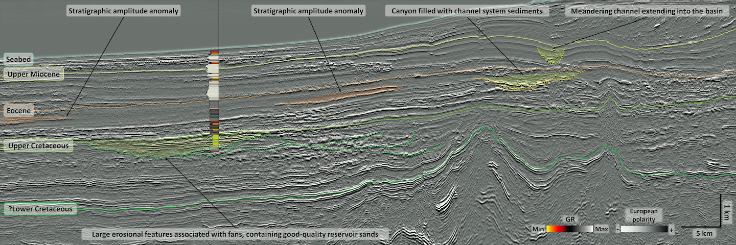 An arbitrary seismic line from the DKC basin showing the main stratigraphic intervals and a number of features of interest for hydrocarbon exploration. The well on the section penetrated Upper Cretaceous good-quality reservoir sands as can be seen in the gamma ray (GR) log.
Cameroon: leveraging three vital drivers for near-term high-impact exploration
Using advanced technologies for better imaging
Advantageous above-surface aspects
Related Articles


