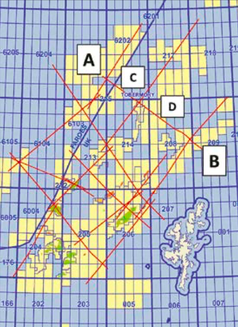
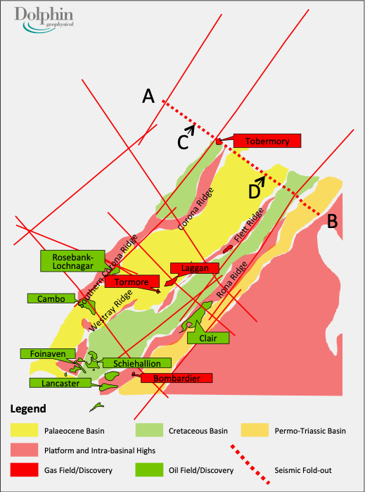
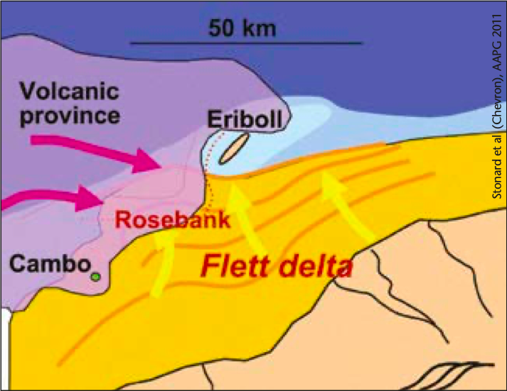
In preparation for the expected increase in exploration activity over the Faroe/West of Shetland area, Dolphin Geophysical, using their vessel the Artemis Arctic, has completed a SHarp broadband 2D regional well tie survey of approximately 2,135 km. This survey ties recently drilled wells, discoveries and fields. The results of this seismic survey have been well received by industry due to the improved imaging throughout the entire geological section, but especially with reference to intra-basalt and sub-basalt features. The use of deep tow streamers and proprietary processing algorithms has resulted in excellent imaging both above and below the basalt in the West of Shetland region, casting light on this fascinating area where challenges are both technical and operational. The main West of Shetland Faroe- Shetland Basin was initiated in the Permian period, and progressive tectonic events resulted in subsidence throughout the Mesozoic and Tertiary eras. The location of the SHarp Broadband 2D Regional Well Tie survey is shown (right) overlain onto a simplified geological map of the area. The red dotted line shows the location of the seismic shown in the foldout and also the enlarged section discussed below. Exploration began in the West of Shetland area in the 1970s, and the Clair field, found in 1977, was the first significant discovery to be made. This is located on the Rona Ridge where oil is trapped in fractured Devonian and Carboniferous reservoir rocks. During the 1980s and early 1990s exploration drilling continued in the Faroe-Shetland Basin but without sig- nificant success, until the Foinaven and Schiehallion fields were discovered in 1992 and 1993 respectively. These fields are in younger Tertiary sandstones, and exhibit good quality reservoir properties. In 2004 a significant oil and gas discovery was made with the Rosebank/Lochnagar well (213/27-1Z) located in the Faroe-Shetland Channel near the UK/Faroes border in 1,100m water depth. This discovery proved a play system consisting of interbedded fluvial and shallow marine clastics and volcanic strata. The sedimentary regime governing the deposition of the reservoir sediments in the Rosebank area was discussed by Stonard et al. at the AAPG in 2011. The diagram on the top of the following page shows a volcanic province encroaching from the west-north- west, and the progradation of the Flett Delta from a south-south-easterly direction. Dolphin Geophysical utilised a 10 km offset streamer with SHarp deep tow parameters, coupled with their proprietary in-house OpenCPS Broadband sequence, and believe they have produced a new regional reference dataset. Dolphin’s broadband product, SHarp, uses a modified towing geometry and proprietary processing algorithms. Towing the cable much deeper than is conventional provides a much quieter dataset as the hydrophones are well away from the sea surface and vessel noise. Lowering the noise floor improves the signal to noise ratio (S/N) and in itself thus allows a broader bandwidth to be achieved in the final image. In addition, towing deep boosts the low frequency response of the receiver ghost and hence increases the signal strength at ultra-low frequencies. This provides a further boost to the S/N at these frequencies. The receiver ghost for the deep cable does contain ‘notches’ in the amplitude spectrum at higher frequencies that are well within the ‘conventional’ bandwidth, but research has shown that there is not perfect cancellation between the upgoing and downgoing waves. As a result the S/N within these notches is sufficient for Dolphin’s proprietary de-ghosting algorithms to recover the full bandwidth – both low and high (Williams et al., First Break, November 2012, Grion et al., SEG 2013). The result for this survey is very high bandwidth and resolution above the basalt and improved low frequency penetration below the basalt. In some areas, clear resolution of intra-basalt layers is observed as well. Unlike some broadband methods, SHarp allows conventional de-multiple techniques and conventional AVO to be applied. This results in more straightforward processing of the data and also lets interpreters use their existing workflows for rock property estimation. The resulting improvement in data quality can clearly be seen in the seismic line below, which is an expanded section of the main foldout line on the previous page. The challenges of exploration in the West of Shetland are both technical and operational. It is classed as a deepwater area with extreme metocean conditions, and due to its location short operational windows are the norm. The geological setting is one where the petroleum reservoirs are interbedded with intrusive and extrusive igneous rocks. This environment is problematic for many aspects of the exploration process including seismic imaging, drilling, and petroleum systems analysis, which has to account for the thermal effects of igneous activity, and also the possible effects upon migration and trapping. A recent paper by Rateau et al. (Petroleum Geoscience, Vol.19) provides an excellent overview of the role of igneous intrusions on the migration of hydrocarbons in the West of Shetland area. For discoveries such as Rosebank the volcanics are interbedded with the reservoir sediments, and hence enhanced imaging as that obtained in this latest broadband survey offers the subsurface personnel another tool with which to explore and develop this difficult but promising area. Ian T. Edwards,
West of Shetland: SHarp broadband 2D regional well tie survey
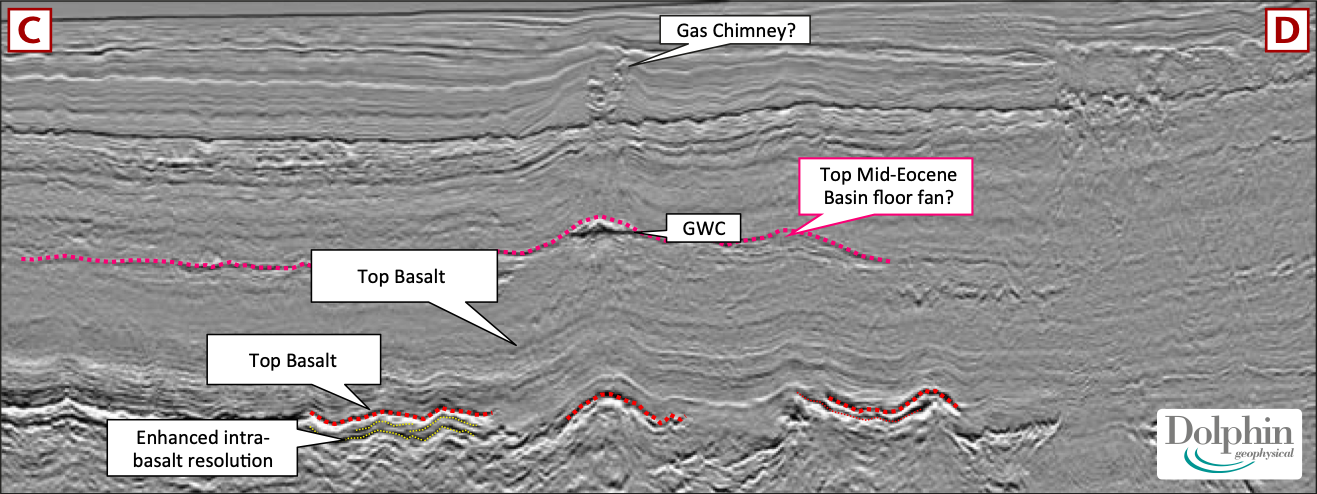
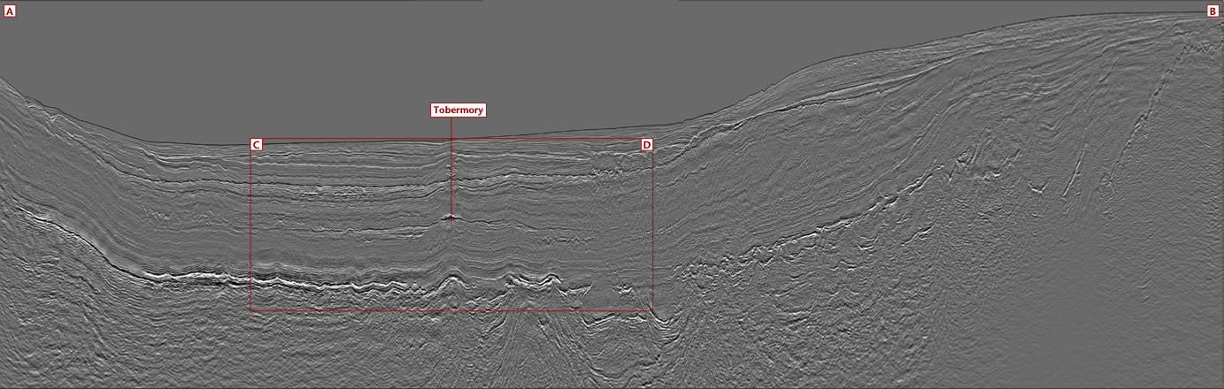 Seismic line from the SHarp Broadband 2D Regional Well Tie Survey, passing through the 1999 Tobermory gas discovery well.
A new regional dataset for West of Shetland
Exploration history
Deep towing and processing
Technical challenges
Further Information
Vice President, Global Multi-Client Surveys & New Ventures E ian.edwards@dolphingeo.com | M +44 (0)7920 713587Related Articles


