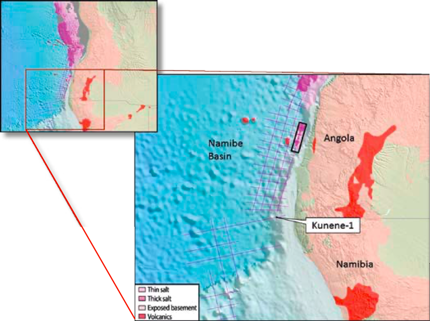
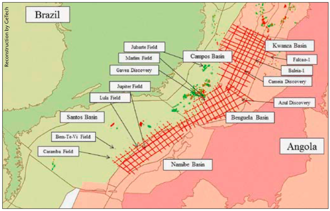
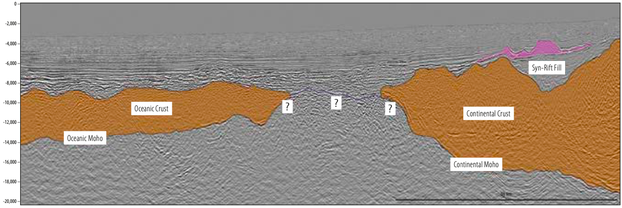
The frontier Namibe Basin holds tremendous potential for hydrocarbons. The offshore West African basins have proven similarities with the equivalent sediments of the Brazilian margin, both part of the Aptian Salt Basin geological province, which formed as the Atlantic Ocean opened. A GeoStreamer® dual-sensor regional 2D seismic survey, acquired in 2011 in association with Sonangol, covers the Angolan sector of the Namibe Basin and has been used to improve regional understanding of the tectonic evolution, geology and prospectivity of the Namibe Basin. The similarities between Atlantic conjugate margins of West Africa and Brazil are brought to the fore through a new regional 2D survey. The sedimentary basins offshore West Africa and the equivalent sediments of the Brazilian margin are both part of the Aptian Salt Basin geological province, which formed as the Atlantic Ocean opened. Significant syn-rift discoveries in the adjacent Kwanza-Benguela Basins, such as the Azul and Cameia fields, and analogous discoveries in the conjugate Brazilian Basins, including Lula and Gavea, highlight the petroleum potential of the Namibe Basin. The Angola offshore area is part of the South Atlantic Salt Basin, which extends from the southern margin of the Niger Delta to the Walvis Ridge (Brownfield and Charpentier, 2006). The offshore basins share similar structural and stratigraphic characteristics due to their common origin during rifting of the proto-Atlantic. The tectonic history is shared with Brazil, on the opposing conjugate margin, as seen in the figure below. The history of these basins is divided by basin development stages. The syn-rift (pre-salt) stage is characterised by extensional faulting, which led to the formation of horst and graben structures. Within the grabens, thick sequences of fluvial-lacustrine sediments were deposited in narrow deep lakes where conditions included a high clastic and terrestrial plant debris input, algal blooms, and anoxic bottom waters. This led to the formation of a world-class source rock lying in close proximity to reservoir facies, ranging from conglomerates and sandstones shed from local horst blocks to lacustrine and fluviatile sandstones. It is likely that several phases of rift block-faulting took place (Karner and Driscoll, 1999). As extensional faulting ceased, the early post-rift, or sag stage, is characterised by the deposition of continental, fluvial and transgressive lagoonal rocks (Teisserenc and Villemin, 1990; Brownfield and Charpentier, 2006). These contain further source and reservoir units. The sag phase sediments of the Brazilian offshore are of significant interest, due to the 2006 discovery of the Lula Field, where the reservoir is a microbial carbonate developed during the sag phase over a large rifted basement structure. The associated source rocks were deposited in laterally-extensive, shallow hypersaline lakes. Subsequent related discoveries have focused exploration activities on the sag phase sediments on both sides of the South Atlantic. These sediments were overlain by an evaporite sequence, accumulated as a result of cycles of marine incursions and evaporation, and this evaporite layer acts as a regional seal. The Namibe Basin is a frontier basin, extending from the Walvis Ridge in the south to the Benguela Basin in the north. The majority of the Namibe Basin lies in Angolan waters, with just the southernmost part lying in Namibian waters (see map on main foldout page). One discovery has been made in the Namibian sector: Kunene-1, which was drilled in 2008 and is reported to be a gas discovery with oil shows in Aptian-Albian sediments, proving a working petroleum system exists. A regional 2D GeoStreamer GSTM was acquired in 2013 in association with Namcor, which ties to the Kunene-1 discovery as well as into the deepwater areas of Namibia to the south of the Walvis Ridge. The present distribution of the salt can be seen on the map on the main foldout page. The Kwanza and Benguela Basins have a significant volume of salt present, contrasting with the restricted volume in the Namibe Basin. Well-developed volcanic centres and lava flows are also identified. With a change in geological character in the Namibe Basin, when compared to both the adjacent and conjugate basins, what is the effect on the hydrocarbon prospectivity? The seismic data shows evidence for syn-rift structures and sediments (see foldout seismic section), analogous to those that have been so prospective elsewhere. A perched basin has been identified containing a well-defined salt body, with a further well-developed sag phase package lying parallel to the base of the salt. The underlying rifted basement rises to north and south, controlling this depocentre. This area of the Namibe Basin not only has potential for hydrocarbons within the pre-salt, syn-rift succession, but the salt itself also provides structure for trapping in post-salt sediments. Further south, the distribution of the salt becomes less clear, and the frequency of volcanics becomes more pronounced. Gravity and magnetics data, acquired with the seismic, will be analysed to confidently determine the distribution of these units. Significantly, within areas that have no apparent salt deposition, there is clear evidence of syn-rift sediments, and structures can be imaged on the seismic. This petroleum play thus remains a likely source of hydrocarbons along the entire length of the Namibe Basin as well as in the basins south of the Walvis Ridge, to which the Namibe Basin is similar, and where an active exploration programme is ongoing. The Namibe Basin regional seismic dataset acquired by PGS has been re-migrated to 30 km, from the original 15 km record length. This has allowed imaging of the deepest structures, leading to a better understanding of the position and structure of the Continent-Ocean Boundary, as shown in the figure below. The timing and nature of the continental breakup along this margin can now be better understood. The frontier Namibe Basin has proven source and reservoir units in both the conjugate basin pair (Santos Basin), and the adjacent basins to the north (Kwanza and Benguela Basins). There is clear evidence of well-developed syn-rift structures and sediments analogous to the prolific pre-salt petroleum play. There is also evidence of a well-developed post-rift succession. The dual-sensor technology places the entire basin in a regional context, and recent re-migration provides details of the deepest structures, allowing understanding of the relationship between the continental and oceanic crust. Brownfield, M.E., and Charpentier, R.R., 2006, Geology and total petroleum systems of the West-Central Coastal Province (7203), West Africa: U.S. Geological Survey Bulletin 2207-B, 52 p. Karner, G.D., and Driscoll, N., 1999, Tectonic and stratigraphic development of the West African and eastern Brazilian margins: insights from quantitative basin modeling. In: Cameron, N.R., Bate, R.H. and Clure, V.S. (eds) The Oil and Gas Habitats of the South Atlantic. Geological Society London, Special Publications, 153, 11–40. Teisserenc, P., and Villemin, J., 1990, Sedimentary basin of Gabon – Geology and oil systems, in Edwards, J.D., and Sangrossi, P.A., eds., Divergent/passive margin basins: American Association of Petroleum Geologists Memoir 48, p. 117–199
Petroleum potential on the offshore Namibe Basin
 Section of a regional MultiClient GeoStreamer strike line, showing a salt-filled, perched basin in the Angolan sector of the Namibe Basin.
Evolution, geology and prospectivity of the Namibe Basin
Regional geology
Namibe Basin
Clear evidence
References
Related Articles


