Northern Viking Graben – Chasing the Upper Jurassic Play
The northern North Sea is a very active oil and gas exploration region, where several commercial discoveries have been made over recent years. Upper Jurassic sands are one of the major reservoirs in the Northern Viking Graben. In recent years, the Upper Jurassic Intra-Heather Formation sands (Sognefjord, Fensfjord formations and equivalents) have been re-explored over the Horda Platform. Wells targeting these sands have resulted in new discoveries such as Swisher, Echino Sør and Blasto as shown in the seismic foldout.

The composite seismic line is taken from the new Northern Viking Graben dual-azimuth dataset where it passes through a number of Upper Jurassic discoveries in an area north of the Troll field and west of the Fram field. Many of these discoveries have been made in recent years, underlining the current ongoing activity and focus on near-field exploration in the area.

Northern North Sea – dual-azimuth data brings new insights into the Upper Jurassic play
Enhanced imaging is achieved in recently processed dual-azimuth 3D seismic data, a combination of legacy north-south acquired data and new east-west acquisition, enabling illumination of prospective Upper Jurassic play targets.
Gravity-driven systems in the Northern North Sea are a major process for the transfer of Upper Jurassic sands into deep-water environments. Active rifting during the Permo-Triassic, and later in the Jurassic – Late Cretaceous, resulted in a series of regional fault terraces thought to be a major influence on gravity-driven pathways and reservoir sand deposition.
The importance of these systems for hydrocarbon exploration can be seen in the Northern North Sea where several discoveries have been made. Fields developed with reservoirs in this succession, such as the Nova Field on the Ryggsteinen Ridge, saw production start from intra-Heather Formation sub-marine sands in July 2022.
Looking at more recent exploration on the Horda Platform, persistent efforts have resulted in new discoveries such as Swisher (35/11-24) in 2020 and Blasto (31/2-22) in 2021, marked in the foldout section. In addition, the Dugong and Sjøpølse discoveries (34/4-15S), drilled on the Tampen Spur in 2020, both proved hydrocarbon-bearing Jurassic sub-marine and slumped sands.
Enhanced imaging of these Upper Jurassic systems has been achieved in recently processed dual-azimuth (DAZ) 3D seismic data over the Northern North Sea. This data set consists of a combination of reprocessed legacy north-south (N-S) acquired seismic (2014-2016) and new east-west (E-W) acquisition (2020-present), where the additional E-W azimuth reveals new details at depth.
The examples presented below bring insight into the subtle features at reservoir level, through spectral decomposition and inversion studies. We demonstrate the extent to which new regional seismic data and sedimentary mapping are integral to understanding Upper Jurassic gravity-driven sediment distribution in a mature hydrocarbon basin.
Identifying depositional sand systems
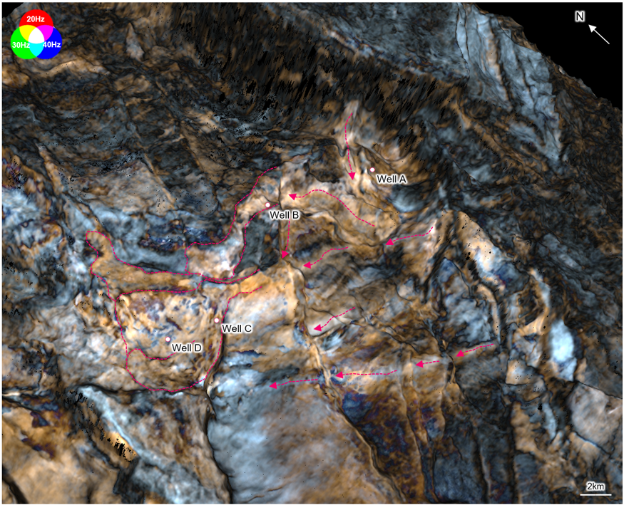
Spectral decomposition has become a vital part of the analysis of stratigraphic formations within 3D seismic data. This attribute has been used to further understand these gravity-driven systems, shown in Figure 1, where an extraction for a single horizon within the Upper Jurassic has been made over an area of ~500 sq km on the Horda Platform.
Bright amplitude anomalies from the colour blending are identified as feeding canyons where sediment-routing systems are interpreted across the closely spaced down-stepping fault terraces, as seen in the Swisher and Echino Sør discoveries. The sinuous transport channels seem to be largely controlled by topography but also influenced by fault geometries. At the base of these systems, we identify deposits fanning out into sand lobe complexes as seen to hold hydrocarbons in discoveries such as Gnomoria and Syrah.
To better understand potential reservoir sand deposition along these systems, Figure 2 shows a composite line taken through Wells A, B, C and D with the relative gamma-ray (GR) logs. Reviewing the GR log responses at the depth of the Upper Jurassic surface seen in Figure 1 (highlighted by a yellow dashed line in Figure 2) we can begin to correlate lithology with the seismic, along the depositional pathways as previously described.
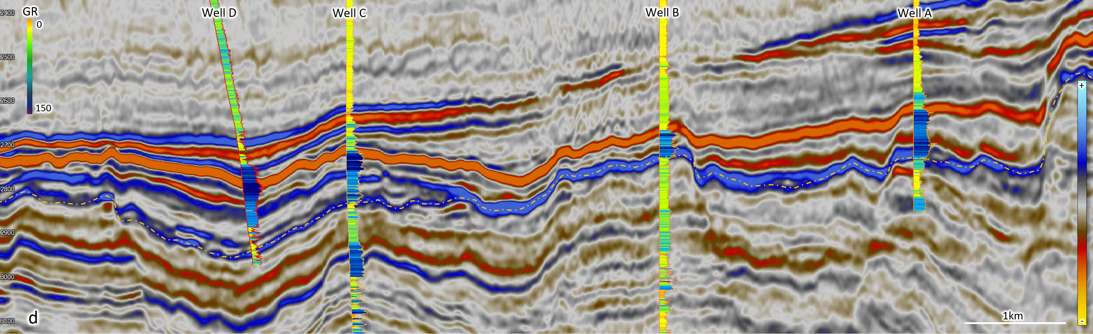
In Wells A and B – Well A is drilled near to the source input and Well B on the inner flank of the canyon system – we can interpret silty sand deposits. As we move further down the system, Wells C and D have been drilled into the end of the depositional system identified as lobe complexes, where log results show clean, thinly stacked sand sequences at this level.
All these wells encountered petroleum within the Upper Jurassic units, indicating a good correlation with the features seen in the spectral decomposition with regard to the deposition of reservoir sands. The depositional pathways as described have been recognised and interpreted on a regional scale using new DAZ data with increased resolution and improved continuity of reflectors, allowing for analogous reservoir sands to be mapped.
Seismic reservoir mapping
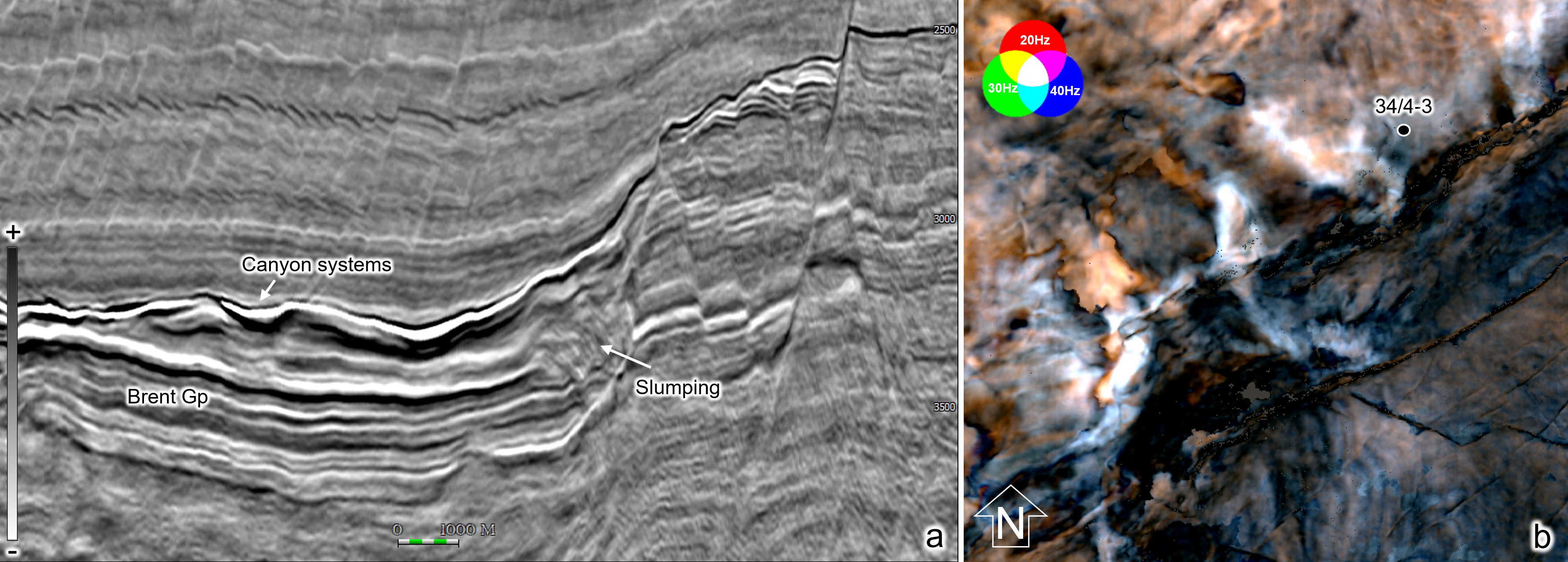
Moving west onto the Tampen Spur, we observe different modes of gravity-driven deposition in the Upper Jurassic succession; these consist of canyon-fed sedimentation, as seen on the Horda Platform, and slumping due to erosion of rotated, steeply dipping fault blocks (Figure 3a). Canyon-driven deposition and interbedded hemipelagic sediments are observed above the shallow marine Brent Group. These are stratified and conformable in contrast to the slumped deposits which are chaotic and deformed (Figure 3a). Examples of both deposits can be seen in the hanging wall of a large fault in an area north of the Dugong discovery (Figure 3b). Results from a recent inversion study conducted over the area allow further evaluation of these reservoir targets through P-impedance and probability of sand extractions.
Seismic inversion studies are particularly beneficial for investigating uncertainties and mapping the probabilities of different lithofacies from seismic amplitudes. Upper Jurassic slumped deposits are identified as dense high-impedance bodies as seen in Figure 4a, where the P-impedance is superimposed on the DAZ seismic section. Likely controlled by erosion, with collapse from structural highs and deposited through a fast-paced system, this would imply the deposits are reworked and lithified, therefore identifying with a dense high impedance response. In contrast, the hemipelagic, canyon-led deposits show a low-impedance response, conforming to the seismic response of these deposits in seismic.
Through a facies classification process, the elastic inversion results can provide the probability of different facies and we can evaluate these details from the most probable sand analysis (Figure 4b). These results correlate well with the gamma-ray log responses in well 34/4-3, which clearly define sand-rich layers at both intervals of the Upper Jurassic as well as the deeper Brent Group (Figure 4b).
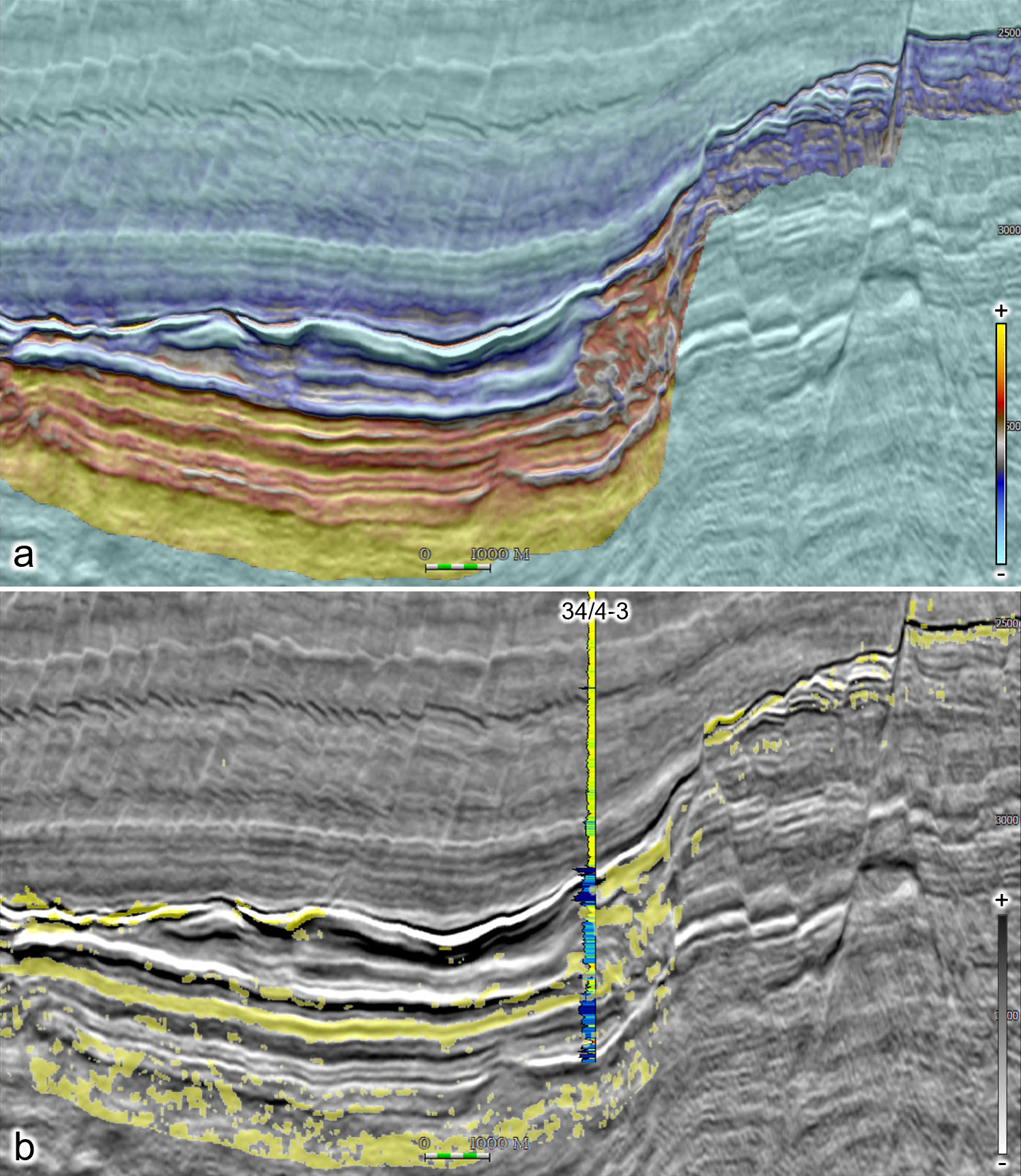
By correlating results from the most probable sands away from well 34/4-3, we see a high probability of sand both in the chaotic slump interval and in the more conformable deposits in the canyons. This indicates potential reservoir intervals in both types of deposits and further de-risks exploration opportunities in the Upper Jurassic as seen from the Sjøpølse discovery in the area.
The availability of a regional dataset, acquired and processed with the latest seismic imaging technologies, is imperative to better understanding the depositional environments of one of the main hydrocarbon plays in the northern North Sea – the Upper Jurassic sandstones, as exemplified in the foldout line and examples above. Using recent discoveries, attribute analysis, and elastic inversion results, we can identify different Upper Jurassic sediment systems. Owing to the complexity of many depositional fairways, these studies show the great need for modern high-quality 3D datasets to better understand how we can identify remaining hydrocarbon potential in the region.


