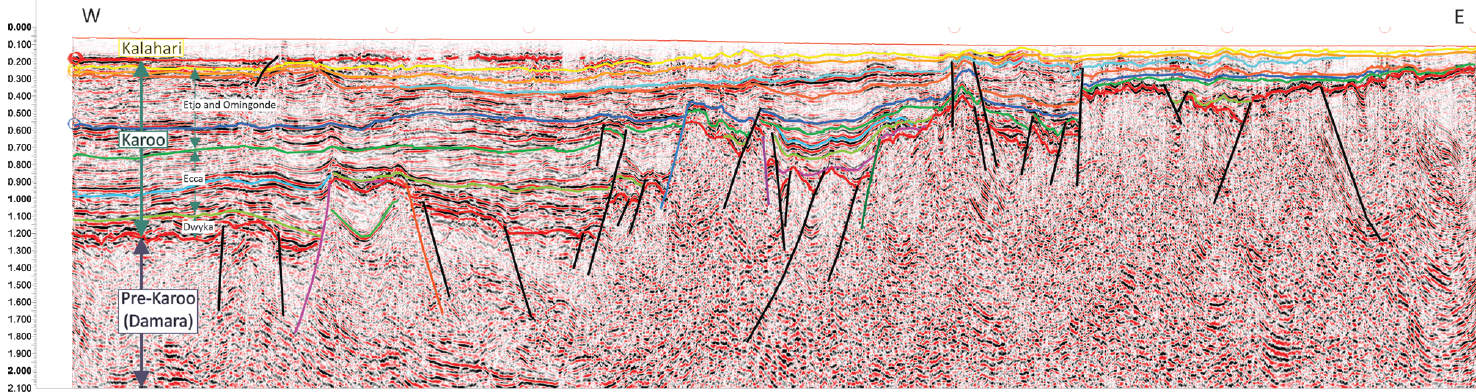
The Karoo Graben - detail of seismic line shown in Figure 3.
ReconAfrica’s exploration program in one of the most underexplored basins
ReconAfrica’s frontier exploration program in the Kavango area, east of the Owambo-Etosha Basin in Namibia continues to yield both surprises and encouragement.
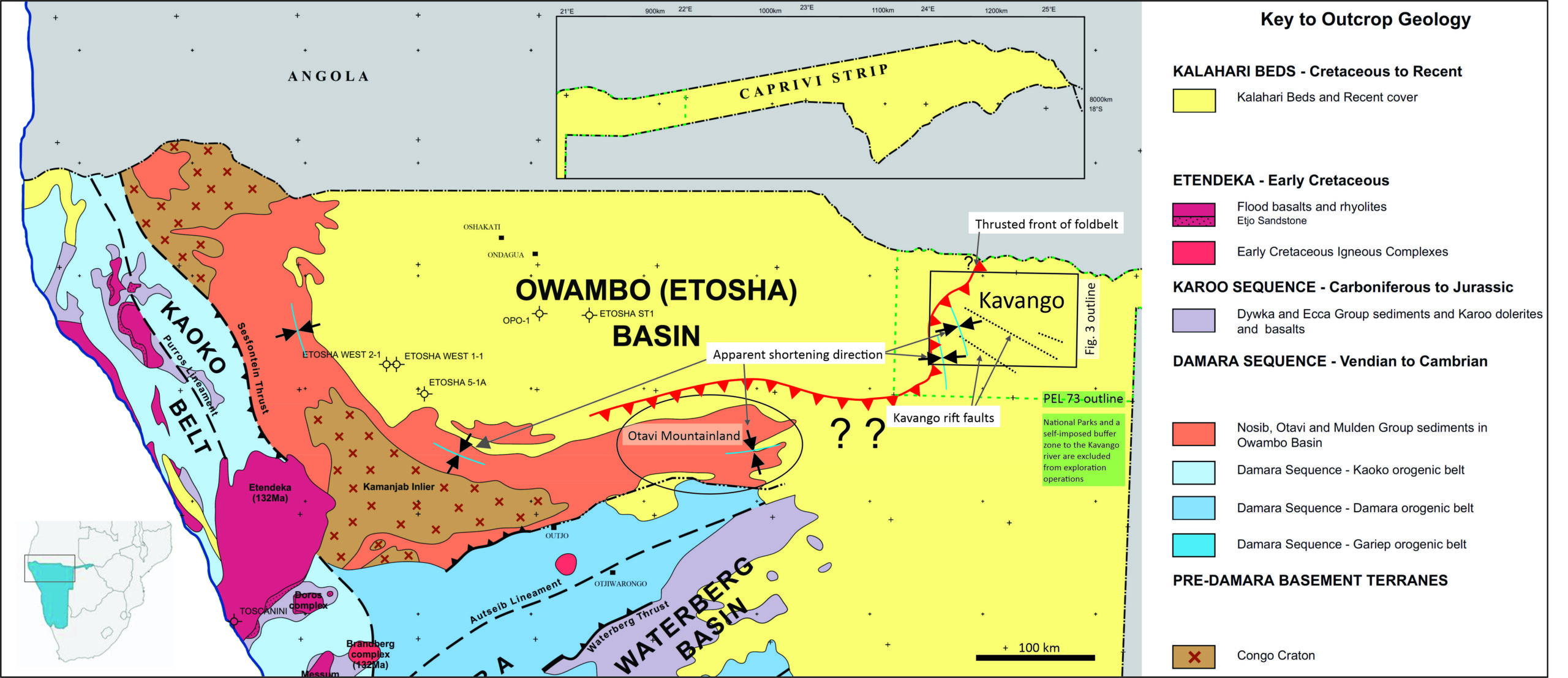
It is a rare opportunity in the twenty-first century to explore an untouched basin for hydrocarbons, but this is the position ReconAfrica finds itself in exploring the Kavango area, east of the Owambo-Etosha Basin in Namibia. Regional studies of Karoo tectonics in East Africa had hinted at the existence of a linked belt of rift-like structures across the African continent, with a Southern Trans-African Rift and Shear System (STARSS) stretching from the East African Rift to the Namibian Coast.
The impetus to license the NE Namibia area was driven by depth-to-basement inversions of high-resolution aeromagnetic data that were carried out by Earthfield Technology at ReconAfrica’s behest in 2014. At that time, the Kavango-area geophysical database was sparse and seismic data were non- existent; only this high-resolution aeromagnetic imaging gave an idea of the deeper subsurface in the area that became the 25,341 km2 large PEL 73 licence acreage (dashed green outline in Figure 1). The closest legacy well to ReconAfrica’s block is well over 200 km away, in the Owambo-Etosha basin, which has long demonstrated the presence of Karoo lying on Neoproterozoic sediments.
In Kavango, no wells other than water wells were present, and from our review only the deepest of them ended in the uppermost Karoo unit, the Jurassic Etjo Sandstone. However, the aeromagnetic data suggested extensional features that could harbour a full Karoo sequence (Late Palaeozoic to Jurassic) rocks occupying grabens associated with the Africa-wide belt. This became termed the ‘Kavango Sedimentary Basin’ to distinguish it from the long-recognised Owambo-Etosha Basin to the west.
ReconAfrica subsequently commissioned a Karoo paleogeographic study for southern Africa that outlined how all these basins might tie together in a model of Karoo depositional systems. Together, these studies formed the conceptual foundation for ReconAfrica’s play in both the Namibian licence and in neighbouring PEL 1 in Botswana.
The first well
Interpretation of the potential field data looked promising for the presence of a previously unidentified deep basin, and in 2020 ReconAfrica decided to drill its first stratigraphic test well. A rig was purchased, transported from Houston to a remote location in the Kavango region, and all efforts were made to ensure the success of drilling operations. Challenges associated with the COVID19 lockdowns, travel restrictions, goods transportation, and supply chain disruptions were eventually mastered, and the rig arrived on site in late 2020. Drilling of the first well, the Kawe well, commenced in January 2021.
The location for the first well (Kawe) was chosen on an intermediate high within the deep part of the basin based on aeromagnetic-derived depth-to- basement maps (Figure 2). This first deep well in the basin was a stratigraphic test designed to reveal the nature and the dimensions of the stratigraphy below what was known from the water wells and to potentially establish whether a petroleum system might be present.
No other data nearby gave any definitive indication of the age of any basin fill that might be present. The Etjo Formation could be on top of a more extensive Karoo section as in the neighbouring Waterberg Basin, or it could just form a thin veneer resting on the Precambrian Mulden Group, which is the case to the west in the Owambo-Etosha Basin proper.
Hydrocarbon shows
The Kawe well intersected the Upper Karoo stratigraphy as expected, and from about 740 m below surface hydrocarbon shows were reported as the drill bit made its way into the Lower Permian Karoo sandstones and shales. Interestingly, light hydrocarbon fluid indicators were stronger than associated gases, and hydrocarbon shows continued into the pre-Karoo stratigraphy. Flow test and downhole fluid sampling tools were not on location as the well was permitted and planned only as a stratigraphic test. Fortunately, the wireline logs, closely spaced cuttings samples and over 180 rotary sidewall cores provided a wealth of information to better understand the newly discovered rift basin with an associated petroleum system.
A second Kavango well (Mbambi) was drilled in the same year. Mbambi also encountered strong gas and fluid indicators over long intervals, but it intersected only 630 m of Mesozoic-Cenozoic basin fill resting on deformed pre-Karoo carbonate and evaporite lithologies. In parallel, surface analyses indicated geochemical anomalies at both well locations, and an active hydrocarbon seep was discovered in the western portion of the licence block.
Seismic acuisition
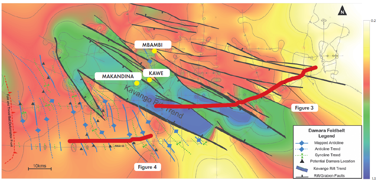
Following the two wells, an initial loose network of about 500 km of 2D seismic data were acquired across most of the northern part of the block (rectangle in Figure 1). This Phase 1 seismic campaign established the initial inventory of leads, 3rd party prospective resource estimates, and a framework for the second phase of seismic acquisition. The third Kavango well (Makandina) followed the completion of another 761 km 2D seismic acquisition.
The most recent seismic survey
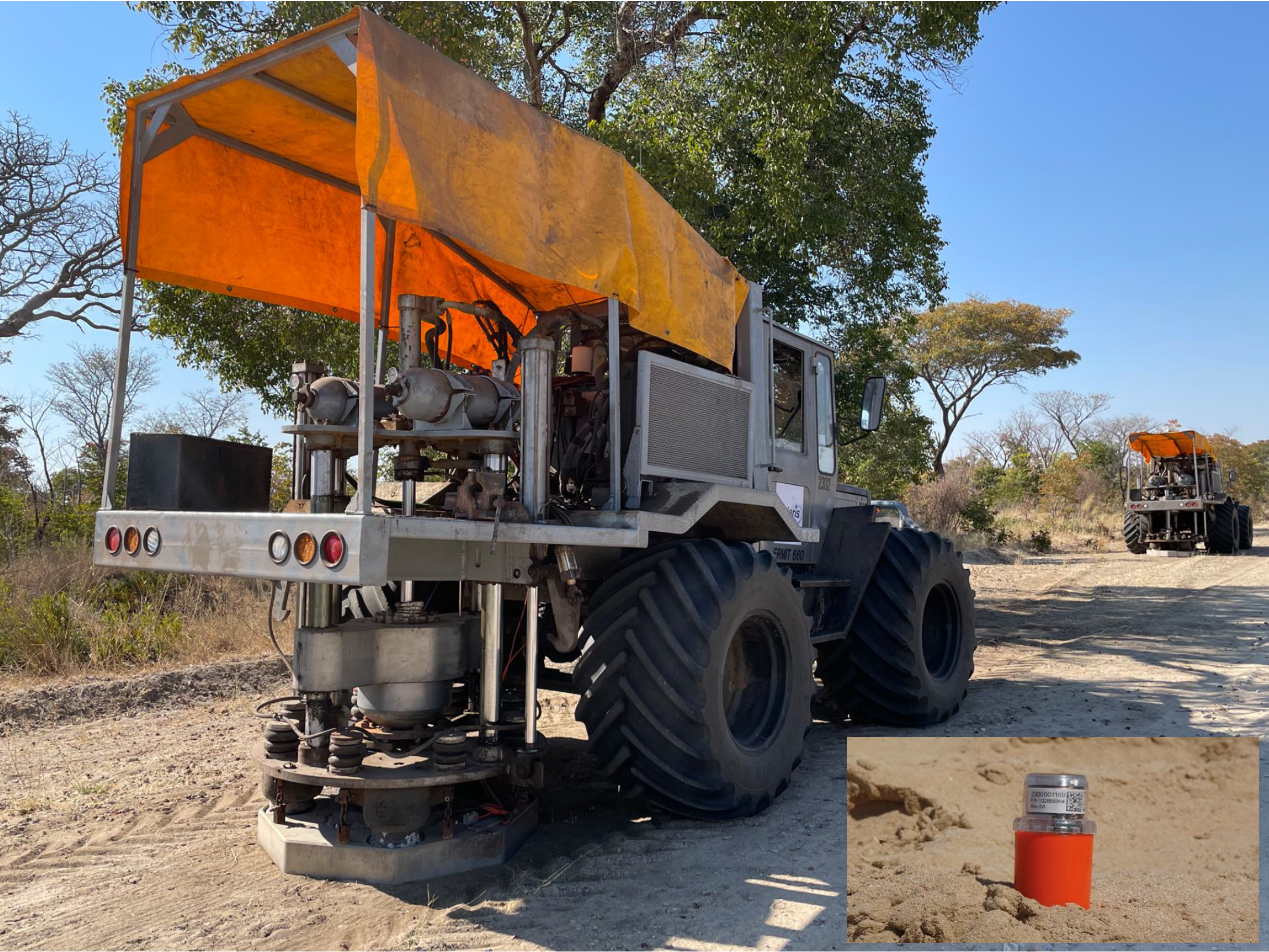
ReconAfrica extended its seismic acquisition program with the goal of acquiring a total of over 2,600 km in late 2022 and the first half of 2023. With acquisition limited at this stage to 2D seismic on existing roads, tracks, and fence lines, an enhanced Full Tensor Gravimetry (eFTG) survey has been permitted to compliment the seismic data. This high-resolution gravity information is expected to improve the interpolation between 2D seismic lines.
ReconAfrica chose to maintain the delicate balance between environmental footprint, sub-surface energy penetration and lateral interpolation with limited seismic control. Therefore, an accelerated weight drop, the Polaris Explorer 860, was used as seismic source. This source is highly manoeuvrable and requires only 3-metre-wide access tracks. In most cases, the existing tracks with minor scrub clearance is sufficient. In contrast, the standard large vibrators would provide a larger energy input but would require somewhat greater clearances than the Explorer and potentially greater noise and vibration.
Following modern trends in seismic acquisition, the project uses Stryde nodes, eliminating all the extra effort for deploying the cables of a conventional recording system and thereby reducing the logistical load associated with moving receivers. Stryde Nodes are small and light weight even by the standards of modern nodes enabling very quick deployment even by crews with limited experience.
Adjustments in acquisition and processing parameters compensate well for the lower energy and noise of the weight-drop source, and the structure within the graben and its base are clearly imaged.
Third well
Makandina was drilled between the end of June and mid-August 2022. As predicted by a nearby seismic line, this third well penetrated an expanded Permian Karoo section, and it encountered light hydrocarbons including gas liquids. It provided crucial stratigraphic and structural information, but the well was not deemed to be commercial. The seismic interpretation had located the Makandina well on a locally defined structure within a Karoo graben, only 6 km west of the first well.
A rift overlying a foldbelt
At present, it is clear that indeed there is a Karoo Rift Basin lying over the easternmost edge of the Owambo-Etosha basin, and that this rift is filled with Karoo Supergroup deposits. An example seismic line (Figure 3) across the Karoo Rift Basin shows the graben structure and growth faults typical of an extensional basin. In addition, seismic data have shown that the rift straddles the frontal fold and thrust belt of the late Precambrian-Cambrian Damara Orogenic Belt. The term ‘Karoo Rift Basin’ is now the preferred terminology within ReconAfrica to describe this rift overlying older rocks.
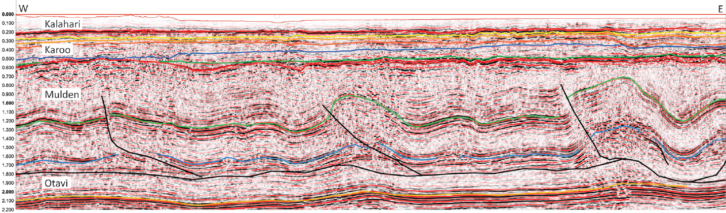
Surprisingly, the deformed strata in the foldbelt also image well with the weight-drop source. With a flat unconformity developed on top of that folded system, unlike data in other more complex thrust belts around the world, the ray path assumptions and subsequent pre-stack time migration in processing is holding up very well. The result is the good seismic imaging shown in Figure 4. Imaging of these older structures, however, is degraded under the Karoo graben itself.
A newly mapped oroclinal bend
The Damara orogenic belt is a prominent feature of Namibia, stretching from the coast eastwards across the country to eventually disappear as it trends under the same Cenozoic Kalahari cover that hides the Karoo Rift Basin.
The seismic data revealed not only that the width of the Damara-age frontal fold belt is larger than was suspected, but also that the fold assemblages undergo a major northward deflection to become north-northwest trending in the licence area. This change in orientation from the west-east oriented structures in Otavi Mountainland, which is the only exposure of the frontal fold belt as developed in sedimentary rocks, is supported by FMI analysis of the bedding data sets from the three wells. They all show strong SSE-trending plunges of pre-Karoo Damara folds.
Thus, the system undergoes a 90-degrees swing, an ‘oroclinal bend’ in the structural grain between PEL 73 and the Otavi Mountainland (Figure 1). These folds occur from some 40 km or more east of the thrust front, a relationship that is not apparent to the west in front of the exposed Damara belt but should persist in one form or another all the way westward to the Kaoko Belt on the west side of the Owambo-Etosha Basin. Subcrop maps in Botswana
suggest that the crystalline core of the Damara belt follows suit with this bend. These relationships clarify that the pre-Karoo Owambo-Etosha Basin is the Damara foreland basin and that it may not extend eastward from the easternmost Kavango region all the way to Botswana as is commonly portrayed on tectonic maps. The Kavango (Karoo-aged) rift system directly overlies this fold belt and more internal parts of the orogen.
Pre-Karoo potential
Stratigraphically, the pre-Karoo in the Kavango resembles the Cryogenian-Ediacaran Otavi and Mulden Groups, likely extending into the Palaeozoic, as supported by palynology and Sr isotope ratio data as well as unique lithologies that were recovered from the wells. This stratigraphic framework could provide multiple source intervals associated with post-glacial anoxic events, as well as carbonate reservoir intervals. In fact, dolomitic shales with over 2% TOC have been sampled in the latest well, and carbonates with good dolomitic matrix and fracture porosity are present. Seismic data reveal trains of large thrust anticlines in the fold belt, which could provide large four-way dip closures each of tens of km2s in size (Figure 3), analogous to some world class hydrocarbon provinces.
These analogies make those large structures in Kavango attractive for exploration, especially as the pre-Karoo strata include potential source, reservoir and seal rocks. The pre-Karoo has been an exploration target further west in the Owambo-Etosha basin, so far only five stratigraphic/exploration wells were drilled between 1964 and 1986 there. Currently, Monitor Exploration is planning their exploration program in the eastern portion of the Owambo-Etosha basin, west of ReconAfrica’s licence acreage.
The next step
In summary, the ReconAfrica exploration program has confirmed the initial play concept of a Permian rift basin in northeast Namibia, with indicators of migrated petroleum. It has also identified a Damara Fold and Thrust Belt play. The company is now completing its regional seismic program alongside the start of acquisition of the eFTG survey and the next well. All will add to the data required to further advance our knowledge of this newly explored basin, and hopefully identify commercial hydrocarbon accumulations.