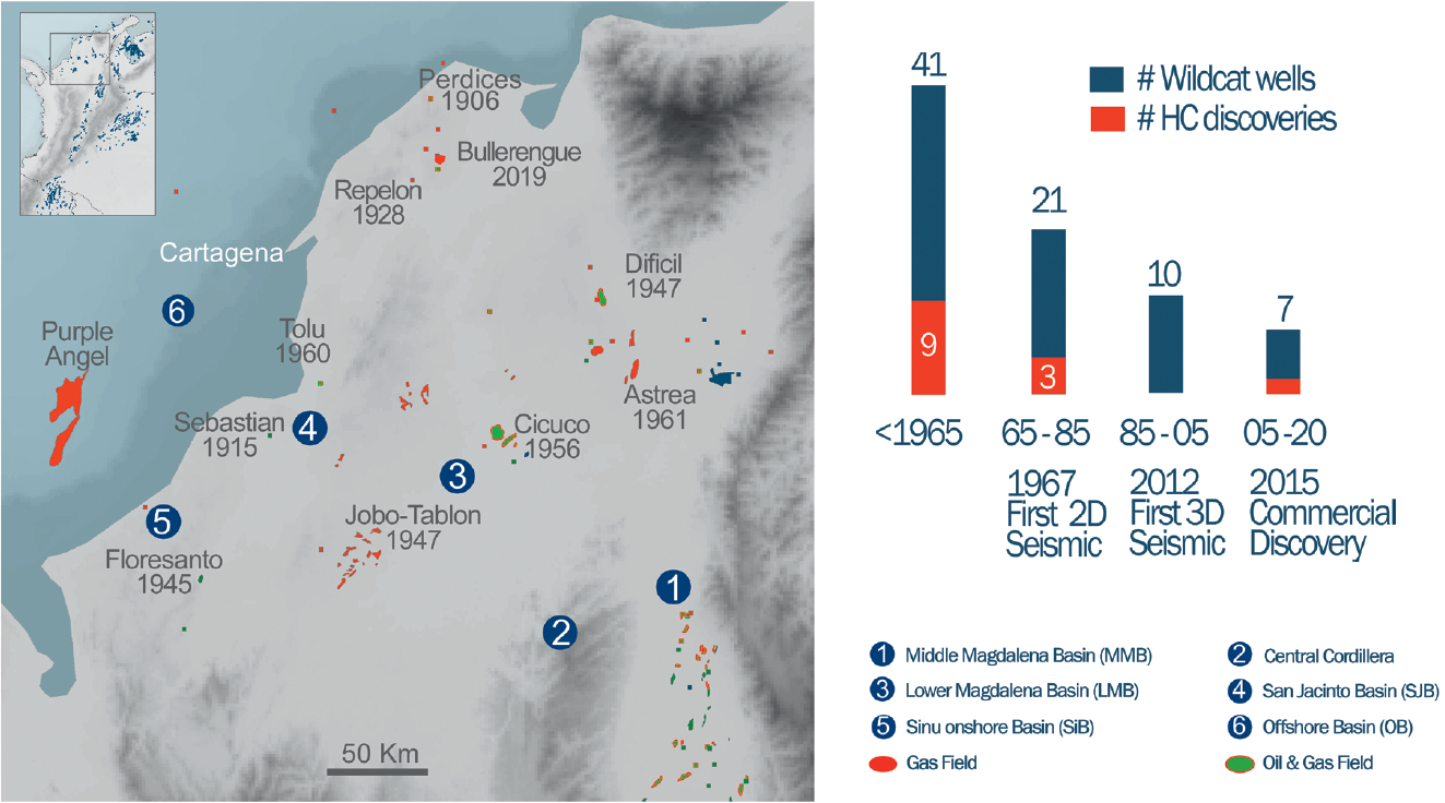
Once again, reprocessing of legacy seismic data, this time in the Sinu Basin onshore Colombia, is providing a critical tool for understanding the geological evolution in order to better evaluate the hydrocarbon potential in this hugely underexplored prolific hydrocarbon basin. Despite having positive well results in the 1920’s and 1940’s, the Sinu and San Jacinto basins remain as some of the least explored areas onshore Colombia. This is due to the classic combination of investment diverting success in neighbouring basins and lack of modern, clear seismic data. The latter has led to unchallenged geologic understanding of the prospectivity. Over the past few years, the application of advanced processing algorithms to legacy data has allowed geological interpreters to challenge the established geological models with paradigm changing insights that will turn this region into a flourishing area for new hydrocarbon discoveries. Explorers first targeted these basins in the early 1900’s, and several small discoveries were made between the 1920’s and 1950’s using surface geology to guide the drill-bit. These wells not only showed that there was potential for oil and gas (Figure 1), but they also revealed that surface geology in this thrust belt did not always reflect subsurface geology. However, numerous large commercial discoveries during the 1940’s and 1950’s in the Lower and Middle Magdalena basins moved attention there. Sinu and San Jacinto today have about 1 exploratory well per 820 square km, whereas the Lower Magdalena basin has 1 exploration well per 350 square km. High structural complexity in the region inhibited early explorers working without seismic, yet the complexities of structure and geology has meant that the subsurface seismic images acquired to date have not generated much appetite for further exploration either. Some of the seismic imaging challenges faced in this project include rough topography resulting in statics both as near-surface refractors and subsurface events as well as making signal alignment difficult. The strongly thrusted environment results in rapidly changing velocities due to highly structured geology. Legacy seismic suffers from poor signal to noise due to penetration of source depending on whether it was dynamite or vibroseis and dissipation of source energy. Finally, legacy acquisition methods from the 1970’s to 2000’s are often associated with limited and/or poor offset distribution. Additionally, older data acquisition methods for recording relied mainly on manual data entries with many errors in observer’s and survey notes. Capturing and fixing these errors can be a very manually intensive job, as well as building geometries and quality control by hand. This latter task is Recent regional studies allow the definition of a new understanding of basin evolution that is changing the perception of the area. Just as has been observed in the Magdalena Valley basins, there is now recognition of a major unconformity associated with deformation and erosion which took place during the Early to Middle Eocene. It has also become clear that there is a marine Cretaceous sequence with good source rock characteristics that can be modelled to explain the distribution of liquid hydrocarbons from oil seeps and wells. Regional studies have also now demonstrated that several sequences of marine reservoirs occur throughout the Tertiary, such as the recent Hocol-operated Eocene reservoired Bullerengue commercial gas discovery (2019), in the north of San As part of a regional reprocessing project (See Basemap above), using state-of-the-art technology focusing on critical aspects including rigorous near-surface velocity modeling (Refraction Tomography) and depth imaging with careful velocity model building (time migration is not considered to be adequate), great improvement has been made on imaging hydrocarbon systems in the Sinu basin. According to these results, the areas commonly associated with mud diapir outcrops (Figure 2), are now related to higher velocities than expected, suggesting the presence of salt in the section (Figure 3), implying that an alternative geological model can be proposed for these complex structures. Even though the Lower Magdalena Valley (LMV) has a well-established history of successful exploration and production, and the hydrocarbons systems are well established, refraction tomography will reveal significant additional potential in the basin. This will re-kindle the LMV creaming curves and many stratigraphic levels. In the Sinu and San Jacinto basins, which represent some of the least explored areas onshore Colombia, the application of advanced algorithms to reprocess legacy seismic data are challenging the established hydrocarbon systems and their inherent geological models directly. In the Sinu Basin, the trap systems previously modelled to be related to mud diapirs could in fact be related to the presence of salt. In turn, along the San Jacinto Fold Belt, the geometry of structures and the presence of a thick unexplored Cretaceous sedimentary sequence, are some of the key insights that will allow explorers to understand these prospective areas in a new and innovative way. New data, unleashing new geological possibilities, reveals plays hitherto discounted. The re-imagined geological evolution of the Sinu and San Jacinto basins is incredibly exciting, encouraging a new era of exploration activity in the very near future.
Revealing new exploration potential onshore Colombia
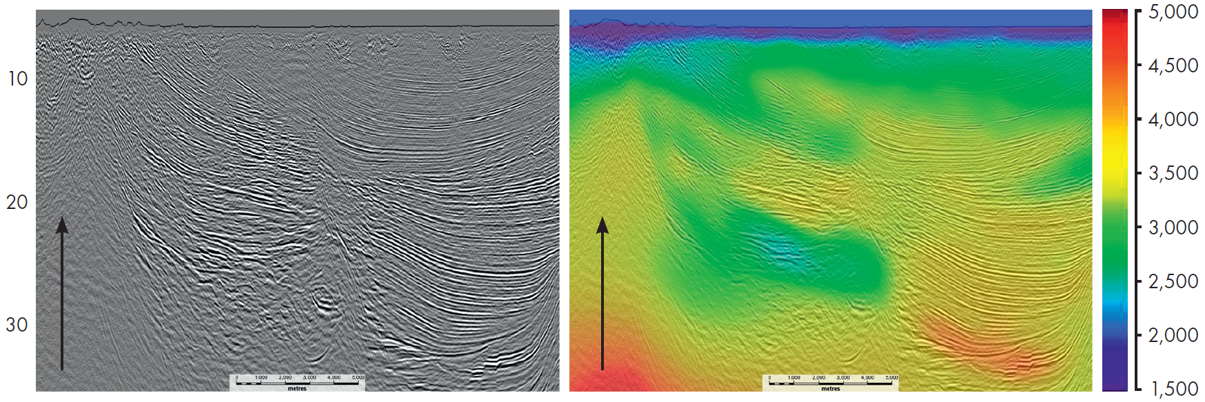
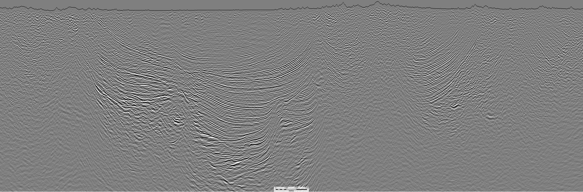 Sine Basin Onshore Colombia: NW to SE 60 km 2D TWT seismic line Searcher reprocessed in 2022 showing unprecedented imaging of the complex structures in this basin, with events imaged in zones with only noise visible in the legacy section.
Shale or Salt – diapiric dance onshore Colombia
Proven hydrocarbon potential
Seismic imaging challenges
best undertaken by those senior geophysicists who worked on these problems 30+ years ago, as that generation of geoscientist are familiar with the old methods and understand observers logs.New geological insights
Jacinto.
Additionally, unexplored thick Cretaceous sedimentary sequences have been revealed along the San Jacinto Fold Belt.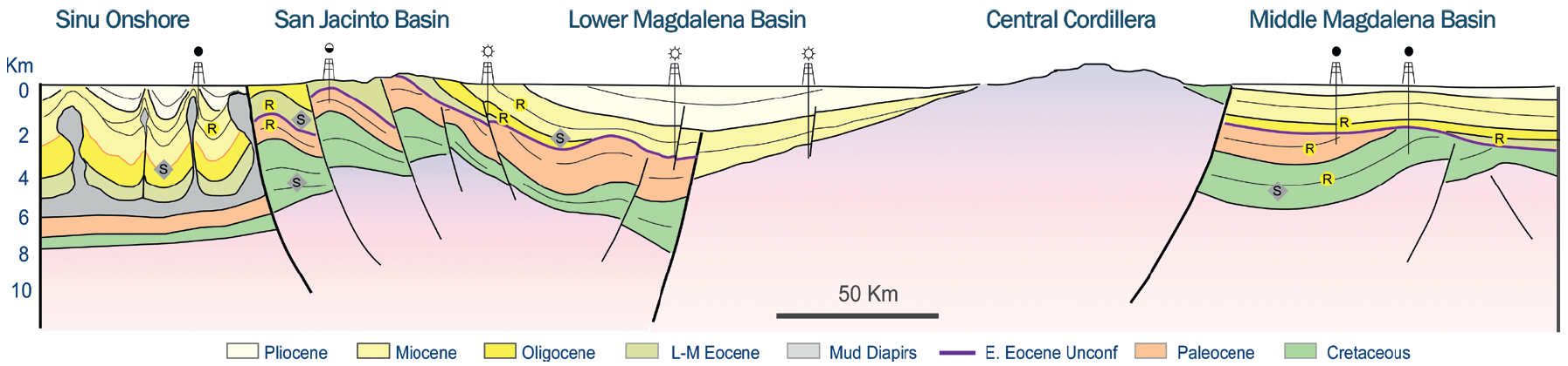
Exploration in the Sinu and San Jacinto basins revived
Related Articles


