
Tasmania – a Geotourism Hotspot
The island of Tasmania is one of Australia’s outstanding National Landscapes. In a 14-day journey around this state, geotourists can explore unique Gondwanan flora and fauna, and a distinctive Aboriginal and post-settlement culture unique from Australia and the world.
Tasmania’s geodiversity is remarkable, representing every past geological period and climatic event. A journey by coach or car will immerse a visitor in one of the most mountainous places in the world and can be augmented with any number of short to multi-day walks, boat and kayaking adventures, mountain biking, strenuous climbing, caving or luxurious food and wine adventures.
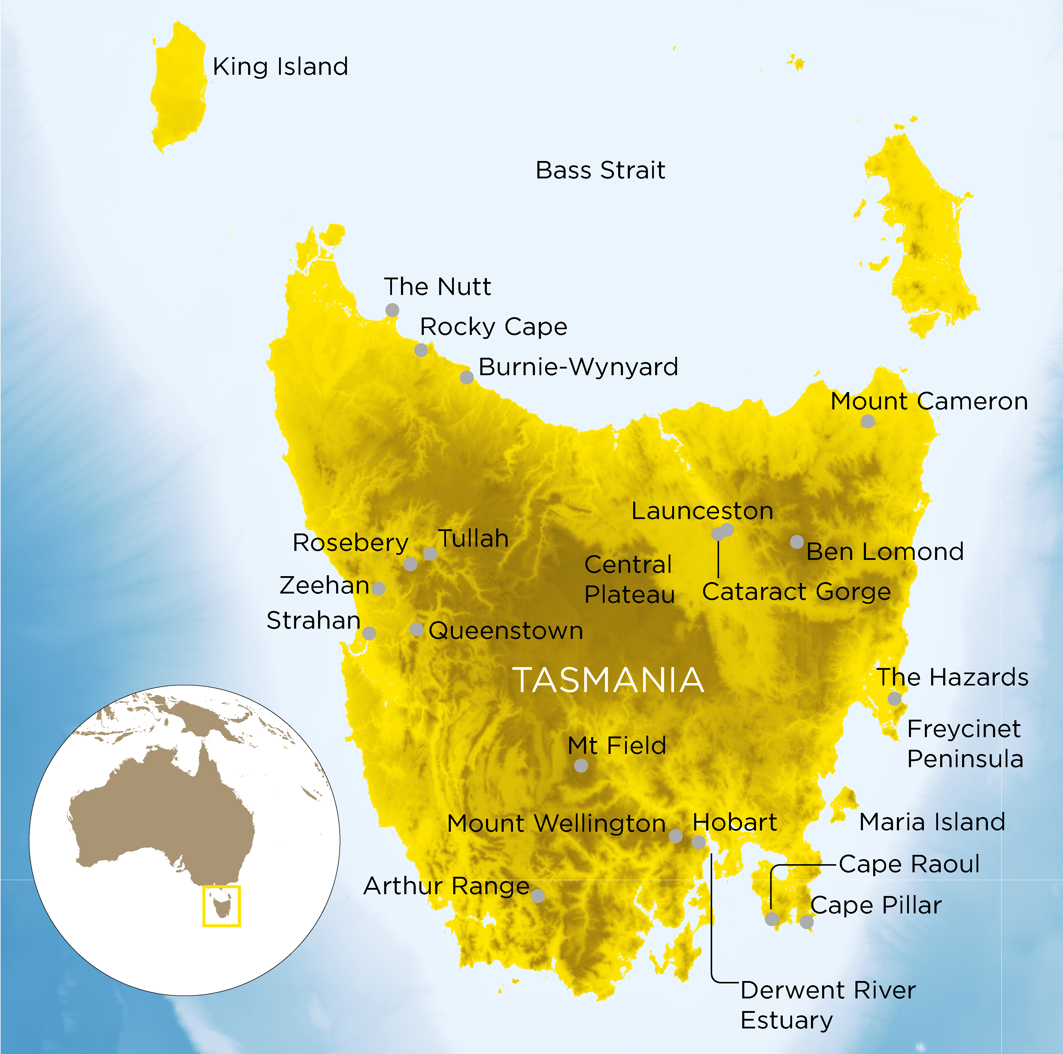
Our journey starts in the north-west – flying over spectacular King Island to Burnie-Wynyard. Heading out of the airport along the Bass Highway towards Rocky Cape will reveal a spectacular vista of the Bass Strait, which separates Tasmania from mainland Australia. The far northwest Rocky Cape marine sediments are Precambrian, and feature monazites, zircons and fossils over a billion years old (1,350 -1,450 Mya). Before arriving, however, a visitor might want to stop off at ‘The Nut’ – a Tertiary basaltic tabletop monument that is but one feature of the more recent development of rocky shorelines along the north coast. At any time, a diversion south off the highway allows visitors to travel through ancient times through a spectacular Gondwanan rainforest. This forest features some of the oldest living plants on earth such as the 10,000-year-old endemic Huon pine trees and alpine pines.
The 99 Bend Road
Western and Central Tasmania began forming 1250 Mya. A trip down towards Strahan reveals the long chaotic history in seas, estuaries, lakes and rivers punctuated by mountain uplift, past glaciation, and faulting. The mining townships between Tullah and Queenstown reveal insights from the Cambrian and subsequent Ordovician periods of intense volcanism and sedimentation.
The Mt Read Volcanics are economically significant and have sustained a 120-year history of polymetallic mining and exploration near Rosebery. This complex volcanic belt has undergone numerous tectonic metamorphic events, with gold-bearing gossans near Mt Lyell and Queenstown, and metamorphosed gabbro and other mafic magmas into serpentine exposures near Zeehan. This landscape features spectacular lakes, incredible flora, and mountain vistas.
Turning inland along the affectionately named ’99 bend road’ (Lyell Highway) from the stark, but colourful, denuded Queenstown hills towards the south will reveal further evidence of past climates in the mountains, rivers, and cave systems. A short trip off-road near Mt Field reveals some of the substantial Ordovician limestone karst complexes of Tasmania, including the deepest (over 400 m) and some of the longest caves mapped in Australia. Further along the road, a turn south will reveal some very ancient landscapes, and contemporary peat bogs. The best-known expression of the old Cambrian quartzites and glacial features in the region is in the Arthur Range, culminating in the impressive rocky crag of Federation Peak.
Dolerites and Dunes
Turning south towards Hobart reveals three charismatic geological settings for which Tasmania is well known – Jurassic Dolerite (diabase), Triassic Sandstones (found in many buildings of convict heritage and outcropping along the Lyell Highway) and Permian, fossil-bearing mudstones. Many short-day trips can be undertaken in Hobart – up the mudstone Kunanyi/Mount Wellington with its characteristic dolerite ‘organ pipe’ dikes and down along the mudstone Derwent River estuary. Travelling across to the south-east will reveal more sandstones in buildings and the Tasman Peninsula, where dramatic dolerite coastal cliffs also rise from the rough surf at Capes Raoul, Pillar with sharp outcrops protruding from the water, showcasing spectacular jointing and fault control.
Eastern Tasmania’s sandstones and Devonian granites are spectacular. In the southeast, sandstones can be found in old convict constructed built heritage, on the Tasman Peninsula and on Maria Island. The first glimpse of granite is found at The Hazards – a pink feldspathic granite range, and the spectacular white ‘Friendly Beaches’ on the Freycinet Peninsula. The famous Bay of Fires on the north-east coast, with its bright orange lichen cover, is a series of I- and S-type granodiorite plumes that dip into the Bass Strait and South Pacific Ocean. Heading a few kilometres inland towards Mount Cameron reveals the remnants of an old tin mine, which has stained waters with copper sulphates, aptly named ‘Blue Lake’.
The remaining trip winds back via the spectacular dunes of the north-coast Bass Strait towards Launceston, to celebrate the world’s largest expressions of dolerite across the central north. Cataract Gorge is a great place to picnic and easily traverse a dolerite riverside track. Nearby Ben Lomond features 100 sq km of alpine plateau atop spectacular dolerite vistas and Central Plateau – the largest exposure of dolerite in the world.
A visit ‘Down Under’ is incomplete without experiencing Tasmania’s truly diverse and outstanding landforms, geology, flora, and plentiful and diverse native wildlife, all within a cultural landscape which completes an outstanding geotourism experience.
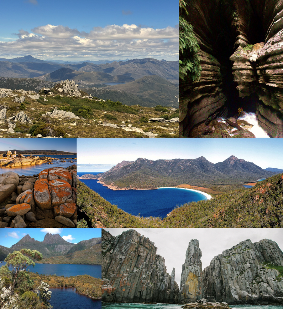
Just some of the incredible Tasmanian landscapes. Clockwise from top left: Mt Read (1,123 m/3,684 ft) volcanics and remnants of past glaciations throughout the Tasmanian Wilderness World Heritage Area in the distance; Growling Swallet – a 360 m (1,118 ft) deep limestone cave containing parts of the Junee River and waterfalls that suddenly ’vanish’ from the surface near the Junee Cave; Eastern Granites and coasts at the Bay of Fires and Wineglass Bay; and some of Tasmania’s unique dolerite expressions at Cradle Mountain and Cape Hauy.
Dr Melinda McHenry, Mark Williams, Violet Harrison-Day, Tzigane Scholz-Talbot, University of Tasmania, School of Geography, Planning & Spatial Science; Angus M Robinson, Leisure Solutions®