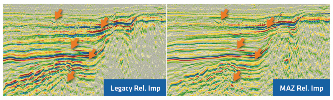
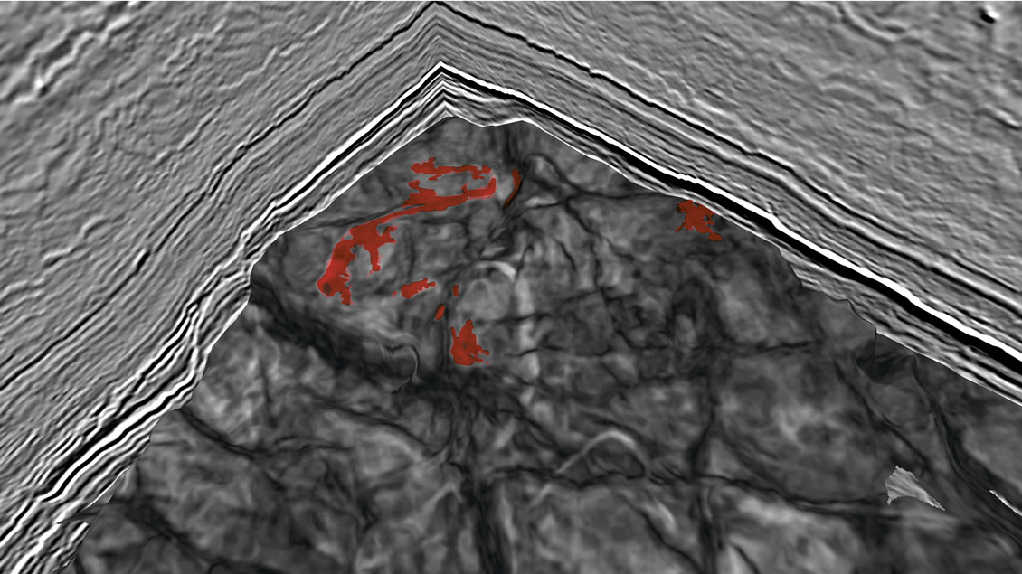
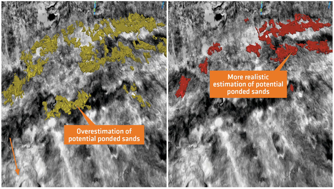
Following a very successful 2019 GeoStreamer X survey in the South Viking Graben, Norway, an additional multi-azimuth survey was acquired further north covering the Utsira High and the Vana Sub-basin. This case study will review the main imaging benefits of various stratigraphic intervals such as the Tertiary and the deeper Jurassic. The implemented technologies and methodologies have enabled the accurate estimation of reservoir properties as well as highlighting the underexplored Vana Sub-basin and near-field opportunities on the Utsira High. A combination of innovative acquisition, quantitative interpretation, and seismic morphology interpretation delivers enhanced understanding of the main prospective stratigraphic intervals (Tertiary–Jurassic) and an improved assessment of the volumetry of exploration targets. This full stack GeoStreamer X PSDM north to south line transects the two recent multi-azimuth seismic surveys in the South Viking Graben. In addition to the seismic display (in relief grey colour scale), a full waveform inversion (FWI) velocity section is co-rendered. The overall depth range is between 0 and 7 km. This combination of high-resolution velocity data and Accurate imaging and evaluation of the main stratigraphic targets has always been a challenge in the South Viking Graben as various geological features, such as shallow channels, gas pockets, and rugose Late Cretaceous Chalk, distort, obscure, and attenuate the image of the subsurface. High fidelity seismic data is required for near-field exploration, appraisal and field development. The Viking Graben in the North Sea has delivered a significant number of successes across multiple plays ranging from the shallow Tertiary to the deep Permian and is still an area of intense exploration and development. However, accurate identification, imaging, mapping and evaluation of each specific target with seismic technology has required a step change with the objective to estimate and predict elastic and reservoir properties more accurately and reliably. We build on the previous case study with a similar MAZ dataset to the south, but go a step further by estimating reservoir properties, such as volume of shale (Vsh) and porosity required for volumetric calculations. The 2019 and 2020 GeoStreamer X surveys are located in the South Viking Graben of the Norwegian sector covering the Utsira High and the adjacent Vana Sub-basin. Major fields in this area include the Balder field discovered in 1967, producing from the Heimdal and Hermod formations (Palaeocene age) as well as some injected sands; the Ringhorne field, part of the Balder complex, which produces from the Hugin (Late Jurassic), Ty (Early Palaeocene) and Hermod formations (Late Palaeocene); the Grane field on the eastern part of the survey produces from the Heimdal Formation (Palaeocene) with very good reservoir quality; and the Jotun field, further north in the survey was producing (currently shut down) from the Heimdal Formation. Few discoveries have been made in the deeper Vana Sub-basin part of the survey: the 25/10-11 well was drilled in 2011, targeting the Early Jurassic interval where minor oil and gas was encountered and the Busta prospect (25/7-7) and well 25/7-2 were drilled by ConocoPhillips targeting the Jurassic Intra-Draupne Formation and discovered gas condensate and light oil. The 2020 GeoStreamer X survey has the same configuration as the 2019 survey with minor differences: two new deep-tow (between 25 and 30m) azimuths with 12 streamers 6 km long and spread 93.75m apart, including two 10-km-long streamers for improved Full Waveform Inversion (FWI), and a wide-tow triple source with 250m separation between outer source arrays for more reliable near-offset coverage in the 50–125m range. The benefits of this acquisition set-up are its richer azimuth/offset information and illumination at all depths. The additional acquisition azimuths (two in the 174⁰ and 234⁰ direction) are complementary to the completely reprocessed 2011 narrow-azimuth MultiClient broadband data (114⁰), creating a homogenous multi-azimuth dataset of around 1,650 sq. km. A state-of-the-art pre-processing sequence ensures a seamless merge of all the azimuths into a single 5D dataset prior to Kirchhoff Pre-Stack Depth Migration (KPSDM). The velocity model was obtained through comprehensive Velocity Model Building (VMB) which included using both refractions and reflections for FWI in a MAZ setting. This was key for resolving both shallow and deep velocity anomalies such as channels, shallow gas, high velocity injectites and the chalk layer. Figure 1 illustrates the total gain obtained from high-grading existing data with complementary new acquisition and better imaging workflows. The improvements are observed from shallow to deep – higher clarity and resolution and obvious changes in structural geometry, significantly improving interpretability. Based on the above observations, and with the objective to extract reservoir properties such as volume of sand and porosity, instead of estimating absolute elastic attributes, it was decided to use only the pre-stack seismic amplitudes. A multi-attribute rotation scheme was subsequently implemented to derive the reservoir properties. This multi-attribute rotation scheme (MARS) is the equivalent of the elastic extended impedance but uses a combination of elastic attributes. The workflow was tested at well locations and then applied to seismically derived elastic attributes. The transforms were used to estimate reservoir properties, porosity and volume of shale based on the derived elastic properties (relative acoustic impedance and Vp/Vs). MARS methodology has been implemented on the legacy and the new multi-azimuth datasets with the exact same workflow i.e., relative pre-stack seismic inversion followed by the reservoir property transform described above. On the Utsira High, the deeper Jurassic depositional environment is clearly imaged using this combination of pre-stack amplitude and elastic attributes to discern a fluvial channel system (Figure 2). It is possible to map and detect untested Jurassic porous sands located in the Utsira High based on the above attribute. These sand geobodies apparently correspond to a channel fill complex. With the porosity (derived independently from the interpretation) draped on the interpretation, the highest porosity (above 30%) is present within the channel. These bodies represent sweet spots of significant porous sands that may be attractive exploration targets. The same processing workflow was applied in the Vana Sub-basin targeting Jurassic opportunities. Clear differences can be observed between the legacy narrow-azimuth dataset (Figure 3, left) and the recently acquired and processed multi-azimuth (Figure 3, right). The overall volume using the multi-azimuth dataset appears smaller but is potentially more accurate than using a partial view of the subsurface, thus reducing the uncertainty in the volume estimation. We have demonstrated that new opportunities can be found and characterised in a mature basin such as the Norwegian South Viking Graben with a combination of innovative acquisition, and a seismic-driven reservoir property estimation. Seismic morphology interpretation based on enhanced imaging delivers a better understanding of the Jurassic interval using reliable attributes. The integrated workflow allows an improved assessment and higher confidence in the subsurface volume estimation provides a powerful risking and uncertainty assessment tool.
Accurate Reservoir Attributes Delivered with GeoStreamer X in the South Viking Graben, Norway

accurate imaging of the overburden, highlights various geological features such as channels (causing seismic distortion below and correctly picked up by the FWI velocity field), deep imaging and some small gas pockets represented by a very slow velocity (blue colour in the FWI display).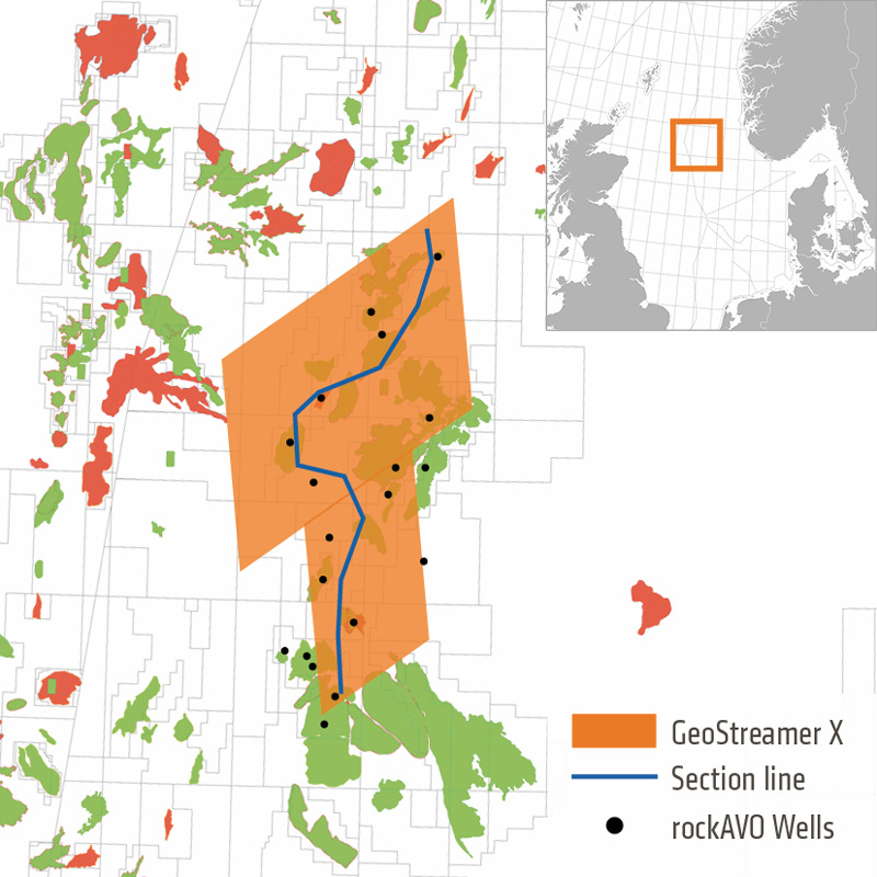
Improving Risk and Uncertainty Assessment using GeoStreamer X Datasets in the South Viking Graben, Norway
GeoStreamer X is an integrated broadband multi-azimuth acquisition and state-of-the-art depth imaging solution. Here, we demonstrate the suitability of the dataset for reservoir evaluation by delineating near-field exploration opportunities and providing better trap and reservoir understanding.
Focusing on the Underexplored Vana Basin
Innovative Acquisition and Processing Deliver Superior Imaging from Shallow to Deep
Reservoir Property Estimation Using the MAZ Dataset
An Integrated Solution for High Fidelity Subsurface Understanding
Related Articles


