Northern North Sea: a dual-azimuth solution
Enhanced 3D dual-azimuth seismic data is an important driver in the search for exploration opportunities and for evaluating the probability of success.

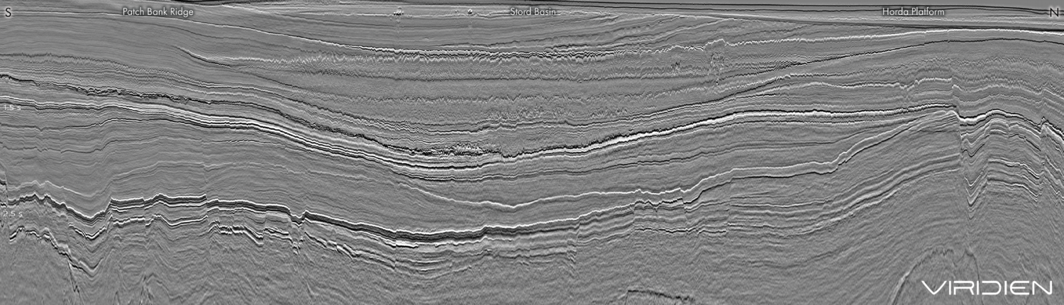
This seismic line (full-width image below) from the new Northern Viking Graben dual-azimuth dataset is oriented north-west to south-east and passes through the Dugong discovery and Snorre field. The line is in the depth domain with overlying TLFWI velocities that isolates a higher-velocity layer in the Hordaland Group in the Paleogene and a lower-velocity feature in the Upper Cretaceous. The final processing of the Northern Viking Graben dual-azimuth data delivers outstanding results that provide significant uplift in the injectite imaging and clearer images of sub-BCU structures and fault architecture.
Northern North Sea: a step-change in de-risking prospectivity
New seismic coverage and high-quality dual-azimuth data over the Northern Viking Graben reveal crucial details for de-risking prospects and encouraging activity.
The need for better data
The focus on near-field exploration is increasing, driving the need for seismic data with improved imaging and resolution. Dual-azimuth (DAZ) seismic, based on a combination of high-density data acquisition and an advanced processing sequence, addresses these needs (see full-width image above and Figure 2). By applying high-resolution time-lag full-waveform inversion (TLFWI) to a dataset combining the two azimuths, the velocity field is significantly improved. This will give the interpreter and decision makers greater confidence in de-risking critical parameters with more accurate evaluation of stratigraphic pinchouts and truncation through improved resolution and higher signal-to-noise ratio and evaluation of fault presence and seal through illumination of faults in multiple directions. Improved data will also allow for new plays and prospects to be identified in areas with challenging imaging conditions.

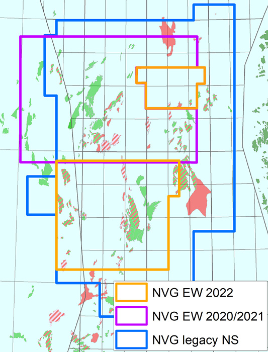
This need for better data has led CGG to start a new multi-year programme (2020 to present) with triple-source and multi-sensor streamer technology, to provide denser spatial sampling and multicomponent data required for enhanced deghosting. The survey, acquired east–west (EW), adds a second azimuth to the existing NVG north–south (NS) survey.
A complete reprocessing of the original NS data is also underway. Both azimuths are used together in crucial processes such as TLFWI for velocity modelling, 4D cooperative noise attenuation, and a fully revised demultiple sequence. The final products are three datasets: a reprocessed volume of the legacy NS data, a new EW volume and a combined DAZ dataset along with a detailed TLFWI velocity model.
Prospectivity and de-risking
Many exploration wells are planned for 2022, including the recently drilled 34/4-18S well on the ‘Statfjord Kile’ prospect. The well is located 3 km NW of the Snorre oil field.
Figure 3a shows the top Statfjord time-structure map overlying a similarity attribute, interpreted on the new DAZ data. Two large fault blocks oriented south-west to north-east can be seen. The northern fault block was drilled by well 34/4-8, which encountered no hydrocarbons in the Statfjord sandstones, and the southern fault block by the new 34/4-18S well, with similar results.

If we compare the well location on seismic sections from the legacy NS and new DAZ data (Figures 3b and 3c), the DAZ data highlights new details that were not imaged on the legacy data, such as an additional reflector above the top Statfjord horizon interpretation (as shown in red). Sub-BCU structures and fault architecture are much better imaged on the dual-azimuth data, as shown by the sharpness of the faults. This allows for improved interpretation of a spatial fault and cross-fault stratigraphy in addition to the identification of new minor, but potentially critical, faults.
Dugong is a recent discovery located west of Snorre with 40–120 MMboe of recoverable resources (Norwegian Petroleum Directorate). The reservoir is the Middle Jurassic Rannoch sandstones, with additional oil found by 34/4-15A in the Upper Jurassic Sjøpølse prospect. In 2021, CGG completed an early-out inversion study using an enhanced fast-track EW product and reprocessed legacy NS data. A massive and continuous sand layer was identified in the Rannoch Formation (Figure 4), as seen on the seismic section through Dugong with an overlay showing high probability of sand (in blue). CGG will continue with a second inversion study using the final processed EW and NS azimuths, and the newly detailed TLFWI velocity field to further improve imaging of the area. During data processing, attention is given to preserving true amplitudes and controlling the phase.

The NVG area contains a wide range of localised near-surface geological anomalies. Shallow gas anomalies typically exhibit high absorption, associated with amplitude attenuation and phase distortion resulting in imaging effects, such as dim zones, uneven image illumination and migration artefacts. Getting the velocity right in these anomalies has a significant impact on the ability to fully image the deeper underlying structures (Figures 5a and 5b).
The new DAZ data shows a significant uplift in the imaging of the injectite architecture with improvements in the sharp and continuous wings of its structure as well as the connectivity between the complex injectite systems (Figure 5).

Technology and experience
With new advances in technology and insight gained from working with data in the Northern North Sea over many years, CGG can apply local geological knowledge and experience, a detailed velocity model and the very latest processing technology to the imaging of the new DAZ product and the two independent azimuths. As seen in the foldout, the final processing of the Northern Viking Graben DAZ data delivers outstanding results that provide significant uplift in the injectite imaging, clearer images of sub-BCU structures and fault architecture, sharpness of fault geometries and an improved ability to resolve the detailed stratigraphy. The three DAZ, EW and NS volumes provide a very good basis for de-risking prospects and identifying new prospective opportunities in a prolific mature area of the North Sea where assessing the subtle critical elements of an interpretation becomes ever more important.
New data acquisitions
In 2022, CGG will continue with new EW acquisition over the legacy NS survey, adding another 9,000 sq km to give the industry the information required to continue creating value from the region. CGG has a long history of bringing innovation to the Northern North Sea to support de-risking of exploration and production and will continue with this commitment into the future. In particular, as part of the 2022 acquisition, CGG plans to acquire sparse node data in the Oseberg area. This will provide data to further improve velocity modelling and imaging in a geologically complex area. CGG expects to deliver even further details for optimising production and supporting near-field exploration in the region.