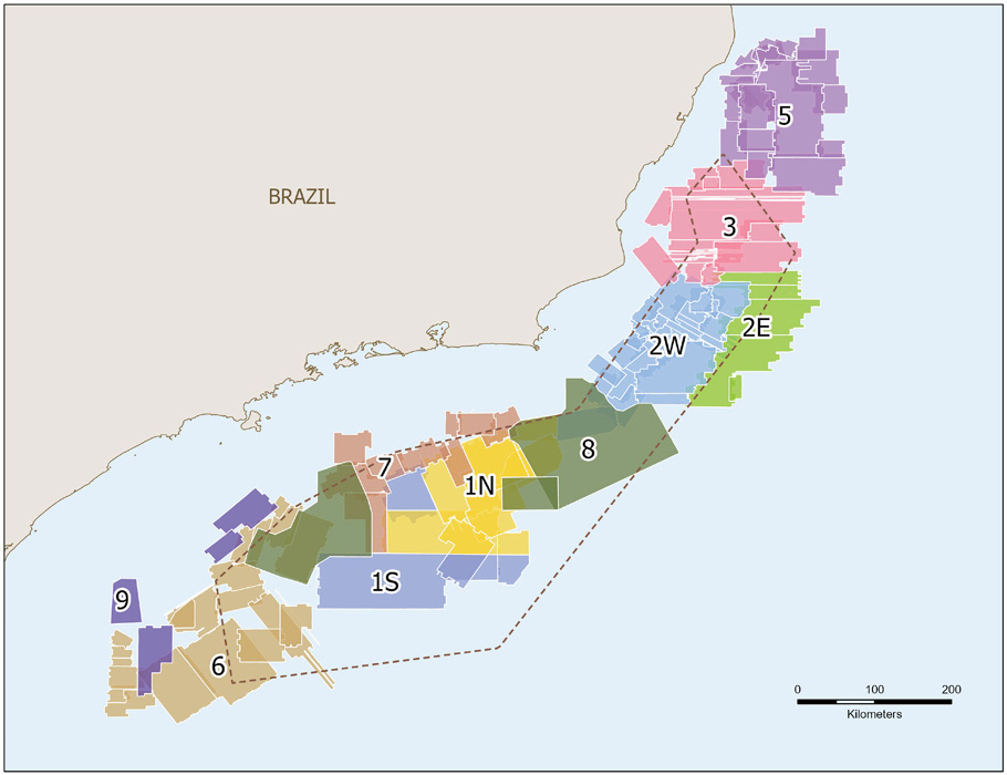
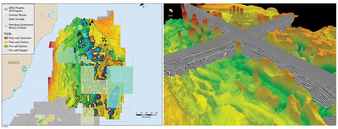
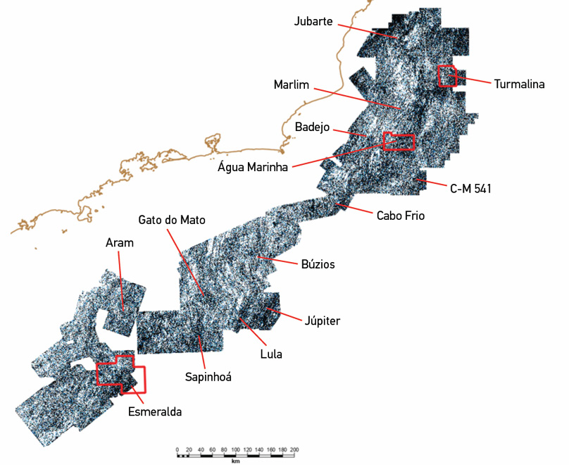
The ION Picanha™ 3D program reimages 275,000 km² of legacy seismic data into one contiguous data volume, enabling visualisation of the subsurface from the Abimael Propagator in the south-western Santos Basin to the Abrolhos Islands in northern Espírito Santo, more than 800 kilometres away. Regional mapping of well-tied geologic markers at major boundaries such as Albian carbonates, Aptian salt layers, and Brazil’s infamous pre-salt sag sequence, reveal linkages between their geologic history and their robust hydrocarbon accumulations. Brazil is the current epicentre of the South American oil and gas industry and ION’s Picanha™ 3D reprocessing program sets a strong foundation for an offshore exploration and production strategy. The multi-client program unifies 115, previously discrete, standalone surveys into one seamless, contiguous regional 3D seismic volume. The integrated program supports national and international oil companies by accelerating exploration insight through regional mapping and prospect generation within an unprecedented 275,000 km2 seismic survey (Figure 2). The Picanha 3D dataset covers three of the prolific Brazilian offshore basins – Santos, Campos, and Espírito Santo – where both localised and regional studies can be evaluated for an improved understanding of the petroleum system and relationships from field to field. High-profile lease blocks such as Esmeralda, Jade, Água Marinha, and Turmalina are all within the Picanha 3D survey limits and were recently redesignated as Permanent Offer blocks (sure to garner plenty of attention as oil giants search for the next Lula field). Starting with just four surveys, the number of input datasets has grown to its current tally of 115, acquired between the years of 1986 and 2013, each with varying acquisition parameters. Upon beginning the Picanha 3D program, the expectation was that it would grow to numerous phases and require a consistent image throughout. This necessitated that the processing, imaging, and interpretation of the data follow a robust, repeatable sequence, while allowing the flexibility to include new technologies as and when available. The benefits of this approach are evident in the seamless, high quality TTI RTM (40 Hz) and Kirchhoff PSDM (90 Hz) stack data, where direct hydrocarbon indicators at post-salt fields such as Marlim, Albacora, Roncador, and Atlanta are confirmed, and pre-salt fields such as Pão de Açúcar, Búzios, Lula, Libra, and Uirapuru are consistently imaged. The dataset includes velocity calibration from over 280 wells, resulting in improved depth imaging of steep-dipping salt flanks and deep basement structures across the region. To date, five phases of the Picanha 3D program have been completed with four more currently underway or scheduled to begin in 2022. The most recent program to be completed is the Picanha Phase 6 dataset. Located in the southwest Santos Basin, Phase 6 covers the inboard side of the famous Santos Outer Basement High, the Aram field, and many Permanent Offer blocks. Phase 6 data displays the potential for Brazil’s shallow water, post-salt, clastic reservoirs juxtaposed against salt diapir flanks or rotated, and fault-bounded traps related to salt evacuation at the Albian Gap. Substantial pre-salt potential is also exposed through the updated imaging of base salt topography ranging from 6–12 km in depth. Within the Esmeralda Block, shown in Figure 3, the updated data show unique opportunities in the pre- and post-salt carbonates. A nearby well confirms the presence of 350 m of pre-salt Barra Velha Formation and TDs in the syn-rift volcanics of the Camboriú Formation, confirming the presence of the proven reservoir components. The block is situated on the south-western side of the Santos Outer High with source migration from the Santos Inner Rift Kitchen where steep basement horsts and grabens display pockets of syn-rift and sag sediments. Proximity to the Florianopolis High and Abimael Propagator represent a complicated crustal regime that triggers vertical salt diapirism in the southernmost Santos, adding another unique variable to exploration in the area. Picanha’s latest addition, Phase 5 (Figure 4), which is scheduled to finish in August 2022, is 800 km north-east of Phase 6 in the Espírito Santo Basin. Here, Permanent Offer blocks are up for lease where updated imaging and velocity calibration techniques are expected to bring out huge upside potential within pre-salt basement onlap plays, as well as Gulf of Mexico-style allochthonous salt-flank plays. The dataset also approaches the Abrolhos Magmatic Province to the north-east. This igneous province is home to seamounts and volcanic islands and is an open area for new play concepts. The interpretation workflow for the Picanha 3D program has evolved from an imaging only workflow to an expanded, geologically driven evaluation of the program area’s prospectivity, risk, and sustainability. The prolific Retiro and Ariri Salt Formations which were deposited during the mid-Cretaceous Aptian period are a critical imaging challenge which the interpretation team tackles using a variety of techniques. A dataset as large and contiguous as Picanha enabled the development and application of machine learning methods, reducing turn-around time by +30% and delivering an accurate starting model for follow-on, FWI-driven proprietary projects. Albian carbonates and basement have also been regionally interpreted not only for velocity constraint, but for a measurement of the petroleum system where isopach maps can be used for pre-salt thickness and sediment depocenter mapping. Throughout the interpretation, comparisons can be made from field to field for insight to hydrocarbon migration evaluation, trap and seal styles, and regional trends which identify potential in open acreage. Analysis of seismic attributes extracted from interpreted geologic surfaces have been used in combination with well data to interpret the geologic evolution of the petroleum system. For example, a semblance extraction from the regional basement surface (Figure 5) reveals patterns associated with fracture zones. High-density chaotic patterns coincidentally trend through known reservoirs, leading to a hypothesis which identifies these as lacustrine shorelines where carbonate platforms and microbialite build-ups of the Barra Velha and Lagoa Feia units are prone. The use of seismic attributes to identify basement fabric associated with volcanics, fractured carbonates, or even post-salt clastic turbidites are just a few applications for the regional dataset, while more detailed rock physics and inversion work can also be performed and tied to well data for reservoir characteristics. The Picanha 3D program unifies offshore Brazil at an unprecedented scale, delivering high quality, regional 3D seismic data from the Abrolhos Volcanic Province, southward through the post-salt amplitude anomalies of the northern Campos, and Cabo Frio; a pre-salt flat spot at the Búzios, and the historic Lula field; then south-west to Esmeralda and the Abimael Propagator. The evergreen approach to the Picanha 3D program will continue to expand its footprint and role as a foundation for exploration insight in this prolific hydrocarbon province. All images courtesy of ION Geophysical Corporation. Note: The images in this digital version of the original article have been scaled down to keep page loading times optimal. You can download and view the original article here (pp42-46).
Unifying offshore Brazil: from the Abimael propagator to the Abrolhos Islands
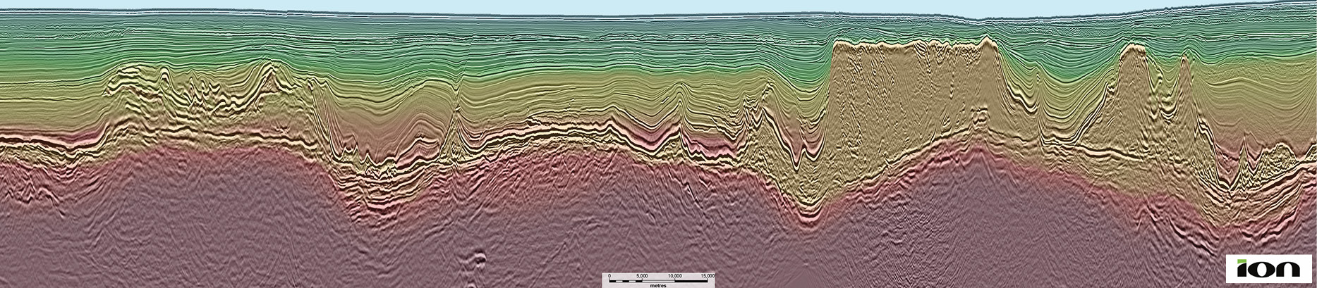 Figure 1B: Cross-section through Picanha Phase 6 in south-western Santos, displaying a unique opportunity within the Esmeralda block. Updated imaging reveals intriguing basement structures and young development of the Ariri Salt canopy at the Abimael Propagator.
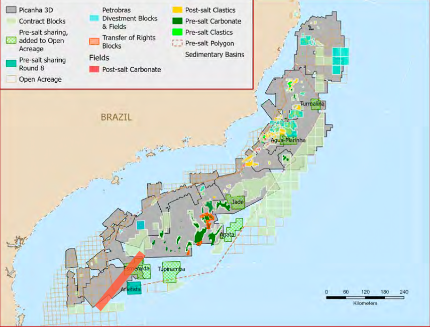
3D processing integrates regional seismic, offshore Brazil
The new Picanha 3D dataset provides the ideal foundation for an exploration and production strategy across a world-class petroleum province.
Broad brush, broadband
Latest datasets

Regional scale perspective
Offshore Brazil unified
Related Articles


