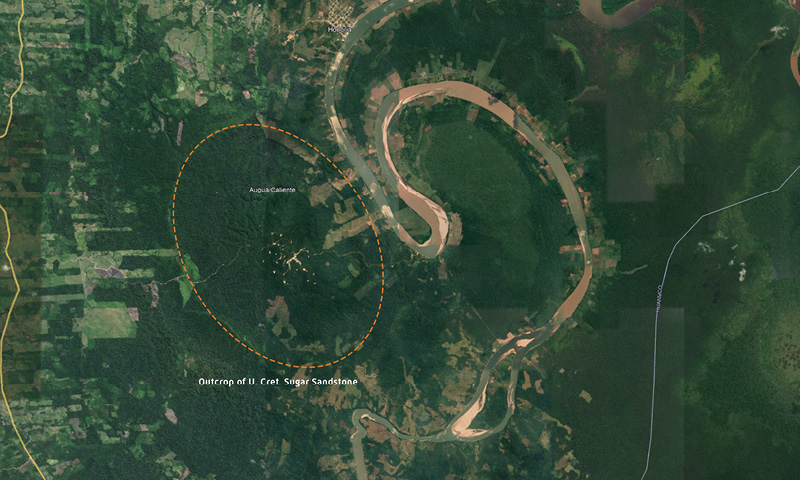
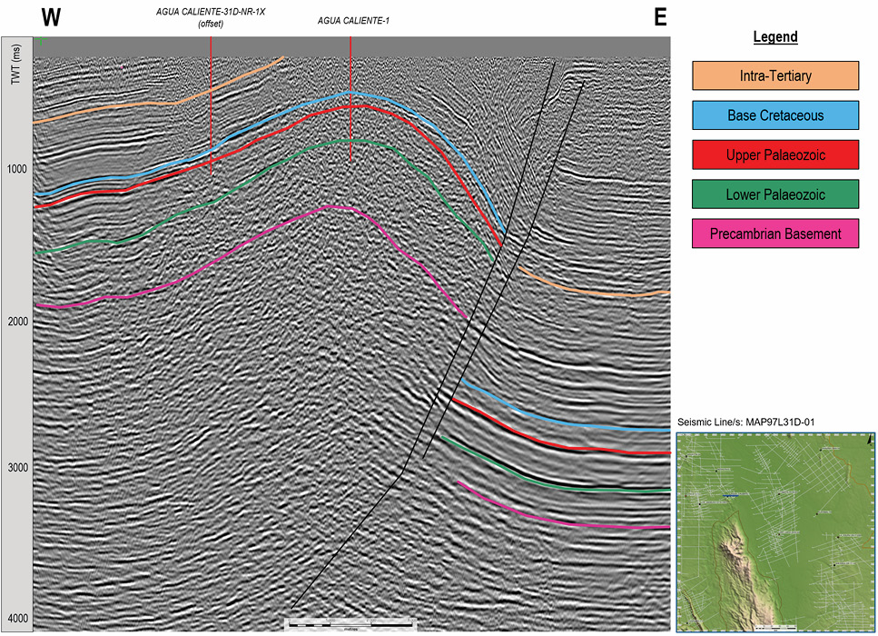
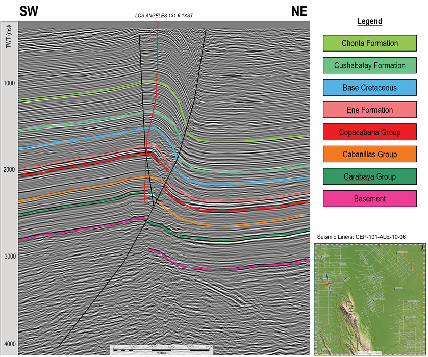
83 years ago, the first oil exploration well east of the Peruvian Andes was spudded on a large surface anticline near the Pachitea River in Peru’s Ucayali Basin. The feature drilled in this pristine rainforest, part of the greater Amazon Basin, was identified on early surface mapping and the presence of ‘boiling rivers’. Only 2 kilometres from the well location hot spring water rose to the surface giving the area, the well, and subsequently the oil field its name: Agua Caliente (‘Hot Water’). In his book, Agua Caliente, Simon Lunn tells the story of Robert Moran, a geologist who had grown up during the Californian oil boom in the early 1900s and understood that anticlines and domes were good places to look for oil. Surprisingly, this story starts with Moran on a twin prop airplane, flying over the rainforests of Peru where he saw sandstone outcrops through the tree line defining a large, oval-shaped four-way dipping dome (Figure 1). Moran had read of first settlers and early explorers finding oil seeps in the mountains to the west and realised that if there were reservoirs to match these indications of source and structure he may have discovered a Peruvian Eldorado – but this one would be a city of black gold. Simon has diligently researched the history of Moran and his co-investors by deciphering their diaries and letters to give an account of the hardships of geological field work in the early 1930s. These men were made of stern stuff – paddling wooden canoes on the Pachitea River through pristine unmapped rainforests, whilst camping and coping with the heat, rain, inquisitive wildlife and swarms of flies and mosquitos, with poor supplies of food and of course no GPS or mobile reception. Thankfully, these courageous adventurers did what most of us today would struggle with, mapping the lithology and dip of outcrops, and collecting fossils (for biostratigraphy) along the river to constrain the geology of the Agua Caliente dome. From Moran’s first ‘remote sensing’ flight over the area, it took eight years of struggle before the discovery well was drilled. We should all read this book and salute our predecessors of exploration. It is a frank, well-told and amazing story, and we highly recommend Simon’s book to you. Today, one can see the Agua Caliente anticline on Google Earth at 8° 49’ 52” S and 74° 43’ 16” W. The exposure that caught Moran’s eye from the air is highlighted in Figure 1 (but better imaged on Google Earth in 3D mode). Whilst we can see the forest around the field has now been ingressed for agriculture, it is still very verdant around the field. The field is now operated by a small, focused company that is taking its environmental responsibilities seriously. Yet the area needs protection and there are groups who one can work with to facilitate that (such as the non-profit ‘Boiling River Project’ dedicated to the protection of the Boiling River of the Amazon and its surrounding Jungle). Today we have something that Moran never had: the availability of excellent quality seismic. Searcher has accessed around 80,000 km of legacy seismic data in the interior of Peru and has ‘rectified’ it into a consistent dataset where navigation is checked, lines tied, amplitudes balanced and phase-corrected, creating one large contiguous dataset. This data is available at low cost via subscription, and accessible via the cloud under the brand of ‘sAIsmic’, enabling regional exploration to be undertaken quickly and cost effectively. As one can see from the foldout section, the seismic data over the Agua Caliente field is extraordinarily good quality. Figure 2 represents an interpreted west–east line crossing the dome, showing clearly not only why the structure is expressed as an anticline at outcrop on the surface, but also revealing the origin of the structure – a deep east-verging thrust in front of the Andean ranges. When the Agua Caliente exploration and development wells are tied to this data, they illustrate the very shallow nature of the trap and reservoir (Figure 2). The field is sourced from the Permian Ene Formation/Devonian Cabanillas Group, and reservoirs are the Cretaceous Paco and Aguanuya Members of the Raya Formation and the Cretaceous Cushabatay Formation. The discovery of Agua Caliente instigated a wave of exploration in the Ucayali Basin that resulted in two more oil discoveries before 1960 (Maquia and Pacaya fields) and 13 gas condensate fields to date in this play (the Camisea gas and condensate fields, located to the south of the Ucayali Basin and the Candamo field in the Madre de Dios Basin, are related to the Early Carboniferous Ambo Formation source rock). Since the 1960s there have been several periods of minimal activity, partly politically driven and partly due to attention being focused elsewhere in Peru. This leaves the play hugely under-explored despite its low risk with proven source and reservoir. Indeed, there are several underexplored plays clear on Figures 2 and 3. Firstly, undrilled deeper stratigraphies are all within closure, such that new hydrocarbon systems could await deeper drilling. Source rocks are found throughout the section from the Devonian Cabanillas Group, Early Carboniferous Ambo Formation, Permian Copacabana and Ene Formations and the Triassic to Jurassic Pucará Group. However, a second, more exciting prospectivity can be found below the Agua Caliente anticline and indeed below the thrust that formed it. The sub-thrust play is a common target in other parts of the Sub-Andean foreland basin regions along the East Andean margin from Colombia to Argentina (Fuentes et al., 2018). Depending on the depth and deformation of the decollement horizon, this sub-thrust play may be simply thrust-sealed or indeed have imbricate stacked targets in what is known as a ‘triangle zone’ below the thrust. The analysis of a number of similar structures in the Ucayali Basin in a ‘Well Atlas and Play Analysis’ by Discover Geoscience, suggests it has not featured as a target in many wells in this basin so far, perhaps suggesting a remarkable opportunity exists across the entire basin. For example, the Aguaytia, Los Angeles and Neshuya structures to the west of Agua Caliente (and for that matter the La Colpa structure to the east of Agua Caliente) are all drilled on surface antiforms and do not reach the sub-thrust play. Whilst very clear on vergence parallel lines, some structures have subtle relief, requiring good seismic to correctly site valid tests. However, the more recent discovery of the Los Angeles field (2012) shows what can be done. Were the sub-thrust play in the Ucayali Basin to be opened up, it will be a testament to the courage and doggedness of the early explorers, and the imagination of the generation that stand on their shoulders, except this time using large cloud-based seismic datasets. The next generation of explorers, empowered with environmental responsibilities and a willingness to work closely with local communities will bring the excitement back to exploration in the hot play – looking for ‘Aceite Caliente’ (Hot Oil) in Peru’s Amazon Basin. Searcher would like to acknowledge Perupetro for their contribution to the text and for allowing us to show the seismic data.
From agua caliente (‘hot water’) to aceite caliente! (‘hot oil!’)
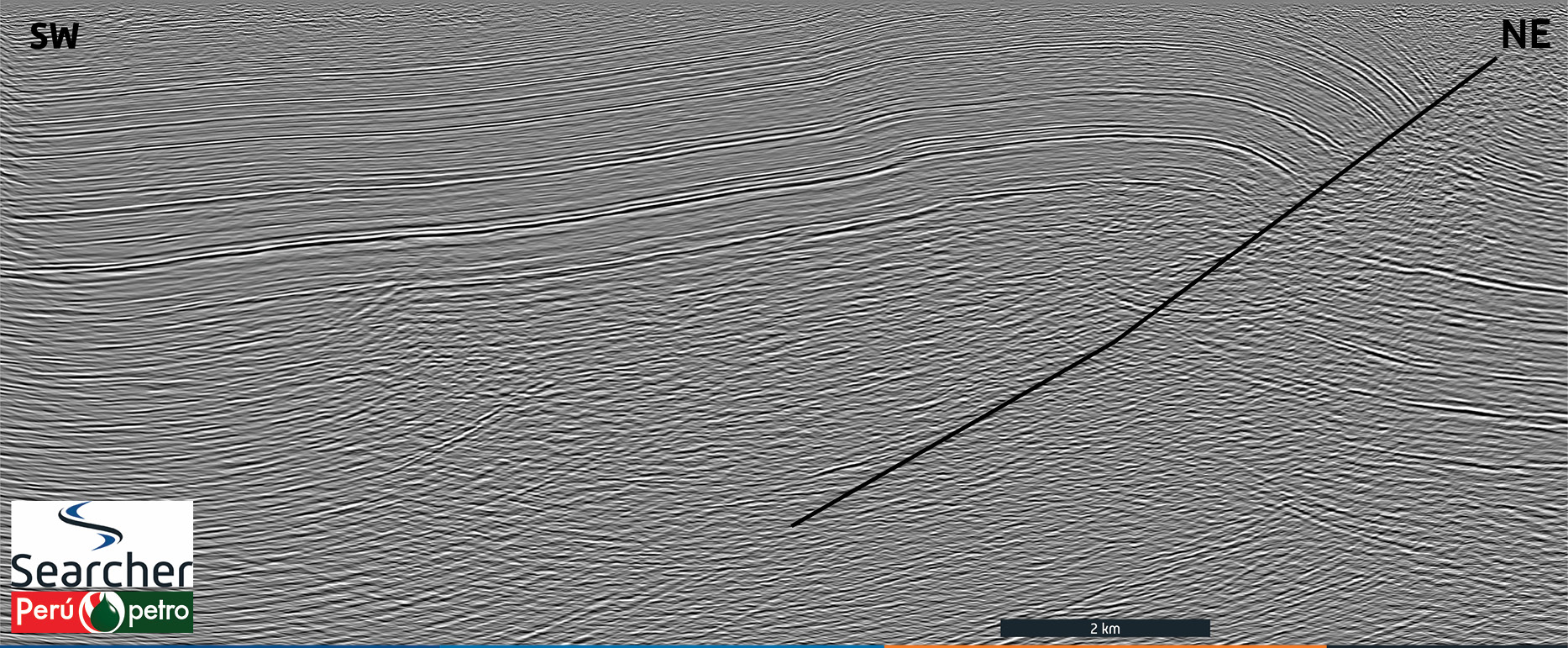 South-west – north-east section across the Agua Caliente Structure. The surface unconformity across the dome is evident. Bright reflectors correlate to limestones in the sequence showing the deep structure, the thrust decollement at basement level of Neoproterozoic age (Reyes Rivera, 2005), and the sub-thrust play.Please note: due to online file size limits we have had to scale down the resolution of this foldout. You can find the higher resolution version on pp42-46 of GEO ExPro Vol. 18, No. 6.

A story of oil exploration in the rainforests of Peru
The heroic story of Peru’s first oil discovery east of the Andes and the passion and determination of the entrepreneurs who made this happen has been brilliantly captured by Simon Lunn in his book Agua Caliente published by Amazon.
Related Articles


