Secure, Geological Disposal of Radioactive Waste
What skills can oil and gas geoscientists contribute to the UK’s delivery of a long term solution to nuclear waste?
Nuclear power generation has been part of the United Kingdom’s energy mix for over 60 years since the first electricity generating plant opened in 1956 at Calder Hall and comprises approximately one fifth of its daily supply today. Nuclear technology also plays a critical role in the National Health Service, industry and defence. There are many strongly held opinions on the future of nuclear in the UK, however one thing is clear: there is a legacy of nuclear waste, which presents an environmental issue that must be dealt with.
Most of the UK’s waste inventory (almost 95% by volume) is what is known as low-level waste and is safely packaged and disposed of primarily at the LLWR facility in Cumbria in the north-west of England. The rest of the higher activity waste, which includes the relatively small volumes of heat-generating ‘High Level Waste’ from reprocessing of spent nuclear fuel, various intermediate-level wastes and a small amount of low-level waste that is unsuitable for disposal at the LLWR, is currently held in interim storage, pending the availability of a final disposal route. All of these wastes are being packaged as solid materials ready for disposal. The UK also holds stocks of other nuclear materials, which are not currently classified as waste but could become so in the future, such as unreprocessed spent nuclear fuel. Individual components of this inventory have different half-lives; however, some of this waste will remain active for hundreds of thousands of years and any permanent disposal system must provide protection over these timescales.
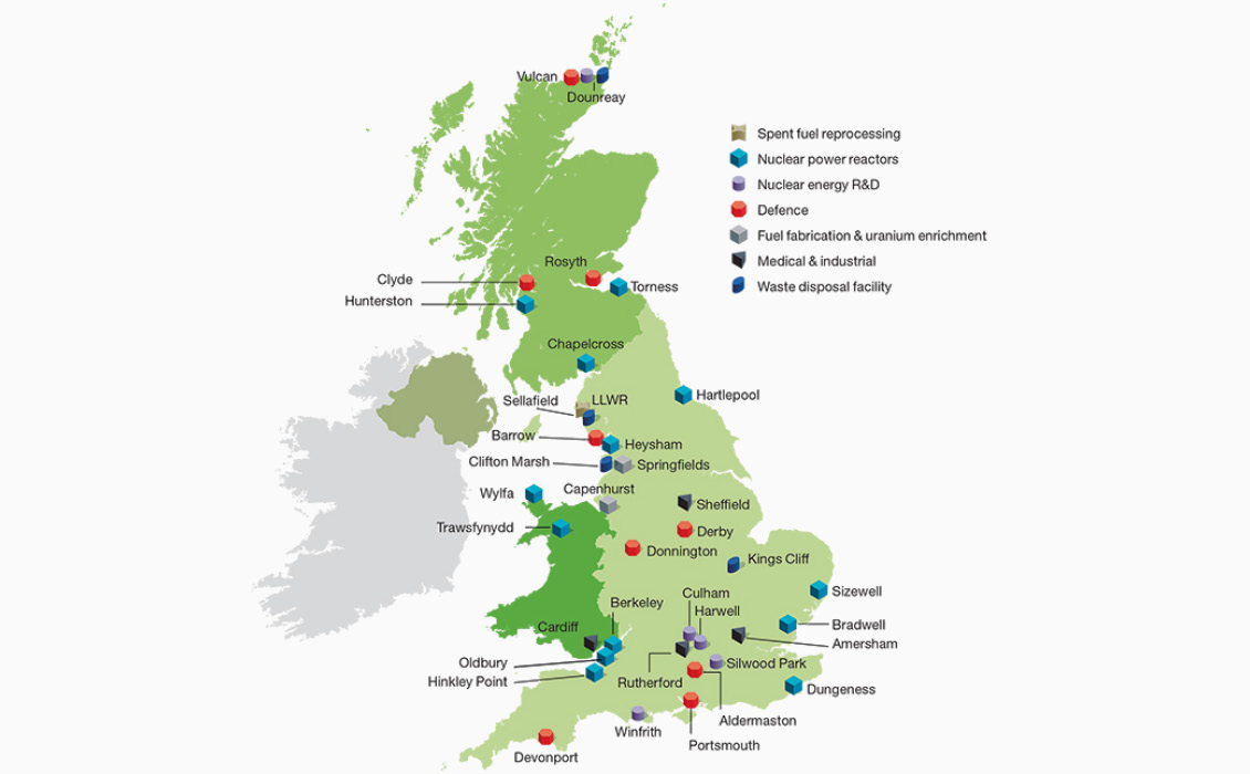
Figure 1: Current locations of radioactive waste facilities. Credit: RWM
Currently this higher level waste is safely stored in specially engineered containers and buildings at over 20 surface nuclear sites around the country (Figure 1); this is a temporary solution and requires regular intervention to maintain safely. As Professor Neil Hyatt, professor of Nuclear Materials Chemistry at the University of Sheffield, has put it: “Technically it is feasible to repackage the waste every few decades and build new stores. However, this is effectively kicking the waste can down a never-ending road; it would be leaving the cost, risk and responsibility of managing and safely disposing of the waste to future generations who did not benefit from the energy generation.”
UK government policy is clear that maintaining waste in these interim stores for the many thousands of years into the future required for its radioactivity to return to safe levels places too high a cost and risk to people and the environment, and it needs to deliver a permanent solution for its higher activity waste.
Successive UK governments have agreed that the safest permanent solution for its higher activity waste is deep geological disposal, in keeping with international consensus and independent scientific opinion. Other countries including Canada, the USA, Sweden, Switzerland, France, Finland and Germany are all progressing plans for geological disposal. A Geological Disposal Facility (GDF) (Figure 2) will allow the waste packages to be isolated hundreds of meters below the ground surface away from economic, political, security or future environmental changes at the surface, without the need for human intervention for the hundreds of thousands of years required for the radioactivity to decay naturally.
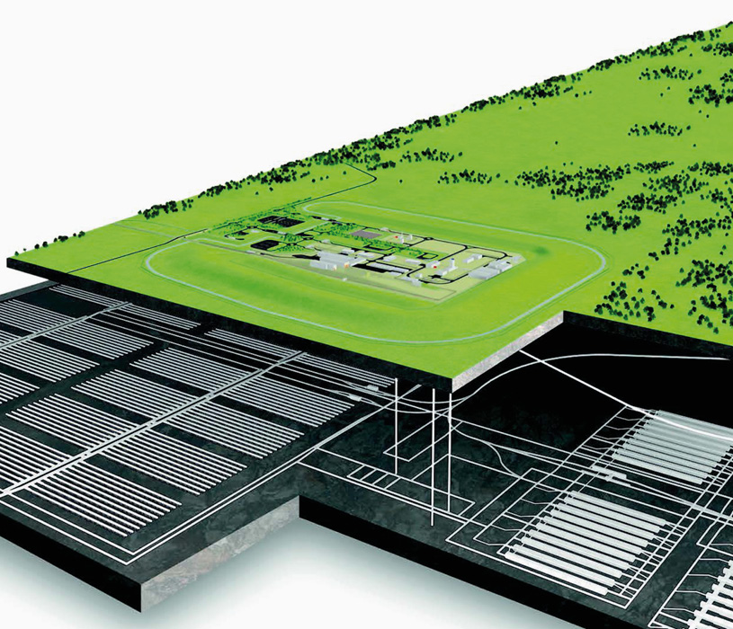
Figure 2: Artist’s impression of what a GDF may look like showing the surface facilities and two separate subsurface storage areas for intermediate and high-level waste. Credit: RWM.
What is Geological Disposal?
Geological disposal is a process by which radioactive waste is isolated deep inside a suitable volume of rock within a highly engineered multibarrier system with the host rock as the final barrier. Done correctly, this ensures that no harmful quantities of radioactivity ever reach the surface environment. The specific multibarrier system components used will depend on the waste type and the host rock but are a combination of several factors including the form of the radioactive waste itself – for example, high-level waste that arises initially as a liquid is converted into a durable, stable, solid glass form before storage and disposal; packaging of the waste; engineered barriers (buffers) that protect the waste packages and limit the movement of radionuclides if they are released from the waste packages in the far future; engineered features of the facility that the waste packages are placed in and stable geological setting (rock) in which the facility is sited (Figure 3).

Figure 3: Example of potential multi-barrier systems. Credit: RWM.
A GDF will comprise a surface site for receiving the waste packages from the transport network and transferring them to the underground facilities, which are expected to have two distinct areas: a system of vaults for the disposal of intermediate-level waste and an array of tunnels for the disposal of high-level waste. The separation is required due to the heat generated by the high-level waste and, potentially, spent fuel if any of this is designated as waste in future. The surface and underground facilities will be linked by a series of shafts or drifts (Figure 2).
The underground facilities will be 200–1,000m below ground level; a minimum 200m is required to be beyond the reach of surface processes such as glaciations over the lifespan of the GDF, and 1,000m is generally considered the maximum depth due to the increase in temperature and pressure with increased overburden thickness. The underground facilities will be completed gradually, over the approximately 100-year operational span of the GDF, as new vaults and tunnels are built, filled and eventually sealed, as required. The design of a GDF, like the multibarrier system, will be dependent on the geological setting; however, it could have a subsurface footprint of 10–20[2 superscript] km. It is possible in some locations that lateral separation might be preferable between the surface and subsurface facilities; as such it is possible that the underground facilities could be beneath the inshore whilst the surface facilities are located a few kilometers away onshore.
In the UK potentially suitable host rocks have been divided into three broad types: higher strength rocks (HSR) – igneous, metamorphic or in certain cases older sedimentary rocks which have very low matrix porosity and permeability, where the dominant method for groundwater flow is through fractures within the rock; lower strength sedimentary rocks (LSSR) – fine-grained sedimentary rocks with low permeability due to high clay mineral content and mechanically weak such that fractures are ‘self-healing’; and finally, evaporite rocks – predominantly halite-dominated evaporites which provide a dry environment and are mechanically weak, undergoing creep where again fractures cannot be sustained.
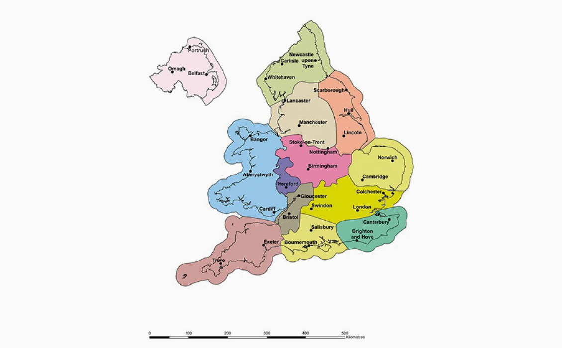
Figure 4: The thirteen geological regions covered by the National Geological Screening. Credit: RWM.
National Geological Screening exercise (NGS) was carried out by RWM, with the BGS, based on guidance developed collaboratively using experience from the geoscience community, our sister organizations overseas and wider interested parties, and reviewed by an independent review panel established by the Geological Society of London. The geological attributes assessed are critical for establishing the longterm safety of a GDF: rock type (as defined above), rock structure (in this case major faults defined as having throws greater than 200m and highly folded zones), groundwater, natural processes (glaciations, earthquakes etc.), and resources (both historical extraction and potential for future exploitation). A series of reports and maps for the 13 BGS-defined regions of England, Wales and Northern Ireland was published in 2018 as a resource for any interested parties or communities in starting communications about the GDF siting process (Figure 4).
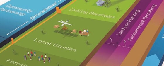
UK and Welsh government policies are clear that site selection for a GDF will be based on community consent and support.* Th is means that the local community will have to expressly consent to hosting a GDF before RWM can seek the necessary permissions to build and operate it. A GDF can also not be built unless RWM can demonstrate that it meets the high standards of safety, security and environmental protection required by the independent regulators, including the Environment Agency and Office for Nuclear Regulation (Figure 5).
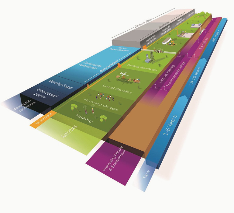
Figure 5: Process for implementing a GDF, this process is initiated by an Interested Party, who may be a landowner, local authority, member of the public, local organisation or company. Credit: RWM.
Site Characterization for a GDF
The GDF program is a unique proposition in major infrastructure projects. Unlike HS2, Crossrail and the Thames Tideway Tunnel, it encompasses not just the surface and shallow subsurface (<100m), but requires the identification and characterization of a volume of rock hundreds of meters below the surface, an accessway of several km, and a much wider detailed understanding of the geology, hydrogeology, structure and future evolution of a significant region around the site to account for longterm safety post-closure. This is where the addition of the skills, knowledge and experience of subsurface professionals from outside the ground investigation and construction engineering industries can be hugely valuable.
The first stage of Site Characterization is similar to a New Ventures investigation. Building upon the information in the National Geological Screening (rather like a CGG ‘Robertson New Ventures Study’), a detailed knowledge base must be built from publicly available data for any area being considered. This legacy data requires QA/QC, interpretation and further analysis including reprocessing of any seismic, building an initial high-level understanding of the potential host rocks, their geometries, overlying and underlying strata, facies and possible characteristics. At this point the Site Characterization team can provide initial models and variables (with large uncertainty ranges) that the hydrogeologists, geotechnical engineers, engineers, and safety case team can use to begin their models, designs, requirements, and feasibility assessments.
The analysis of this legacy data will also create a foundation for the investigative stages of the site characterization; in many cases seismic surveys will be the best source of non-intrusive data gathering. This is one area where experience from the oil and gas industry can be invaluable. Not only is seismic survey design and acquisition (including all the permitting and safety surrounding acquisition) the bread and butter of petroleum geophysicists, but as development of sophisticated acquisition and processing techniques has largely been driven by the requirements of oil and gas exploration and production, the specific requirements of imaging for a GDF site investigation will be an exciting challenge for any subsurface professional.
Importance of Seismic
RWM hopes to be able to begin acquiring our first seismic surveys in 2022, and it will provide many technical challenges to gain high-resolution imaging down to approximately 1.5km, especially in the shallowest sections, without compromising deeper imaging. It is highly likely that at least one community will wish RWM to investigate the inshore area, adding the acquisition challenge of working in very shallow water, transition zones or areas with large tidal ranges. The processing and interpretation of these surveys to gain as detailed an understanding as possible using offset wells will require the specialist expertise of many subsurface disciplines.
At this stage RWM will construct 3D geological models, which will give us an understanding of where within any areas being considered there is likely to be an appropriate volume of potential host rock. Expanding upon this, using many of the techniques developed by the oil industry such as rock physics and seismic inversion, RWM will be able to start populating these models with more constrained parameters, which will allow our colleagues to perform sophisticated modeling and feasibility testing.
RWM anticipates that after the nonintrusive investigation stage there may be a number of prospective sites which will show greater potential than others for hosting a GDF that will meet and exceed the required safety standards; this subset of potential sites might continue in the process.
Carrying on the analogy between a GDF and oil and gas exploration, we might consider this stage to be equivalent to moving from exploration to appraisal of a discovery.
RWM’s drilling campaigns will be targeted slightly differently from classic oil and gas drilling. The mechanics of our borehole planning and data acquisition will be very familiar to petroleum geoscientists. Key differences will be that the full length of several of our boreholes will be cored and logged, and drilling locations will be selected on different requirements, e.g., understanding the hydrogeological properties of what in oil and gas would be considered caprocks, or defining the damage zones around major fault systems; long-term measurements downhole lasting a number of years are likely.
The analysis of the initial borehole drilling will result in the updating of all models and the addition of new models, particularly hydrogeological and geochemical modeling, and a decision on further rounds of drilling investigation.
Our investigative boreholes cannot just be plugged and abandoned. If they potentially impact upon a GDF location then they must be sealed in such a way that they will not adversely affect the post-closure safety case of that GDF. Thus borehole sealing is an extensive area of study and planning at RWM, which needs to be included in any drilling campaign. This is because a borehole near a potential GDF site could affect groundwater circulation and provide an accelerated route back to surface for radionuclides if improperly sealed.
New Careers for Petroleum Geoscientists
The process of site characterization for a GDF is a fascinating blend of almost all the specialisms of geoscience, and myself and several of my colleagues have been lucky enough to move from oil and gas directly into this pursuit. Our daily work includes collaboration with people who are experts in their fields in many diverse areas, such as nuclear waste packaging specialists, civil engineers, ground investigation specialists, tunneling and boring specialists, and many more, constantly being challenged and learning whilst sharing our specialist expertise.
RWM feels very passionately that a GDF is the right solution for nuclear waste in the UK and works with an experienced supply chain that encompasses experience of major infrastructure projects, nuclear projects, renewable energy and oil and gas projects. As we progress down our path towards investigating and identifying sites and delivering geological disposal capacity for the UK, we will need increasing support from experienced geologists, geophysicists, drilling engineers, geotechnical engineers, geomechanics specialists, and many others. These experts will come from mining, oil and gas, civil engineering, nuclear, and many other industries, and what makes this a challenging and exciting project to work on is how much we all have to contribute and learn from each other.
Note
* Radioactive waste management is a devolved issue in the United Kingdom and the UK government in Westminster has responsibility for the policy only in England. The Welsh government has published its own policy on working with communities, and there are no plans to site a GDF in Northern Ireland. The screening report is purely a technical exercise. Any future policy decision on geological disposal in Northern Ireland would be a matter for the Executive.
References
- Department for Business, Energy & Industrial Strategy (BEIS), Implementing Geological Disposal –Working With Communities, December 2018.
- RWM, National Geological Screening, 2018. (http://www.gov.uk/guidance/about-national-geological-screening-ngs)


