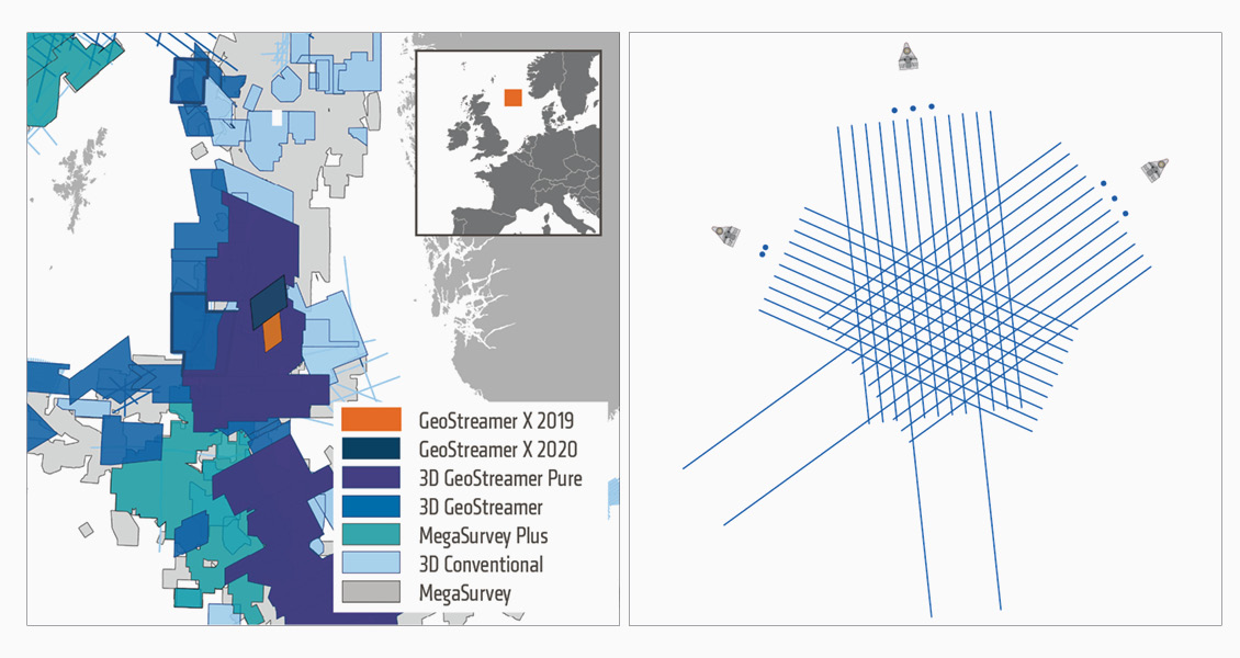
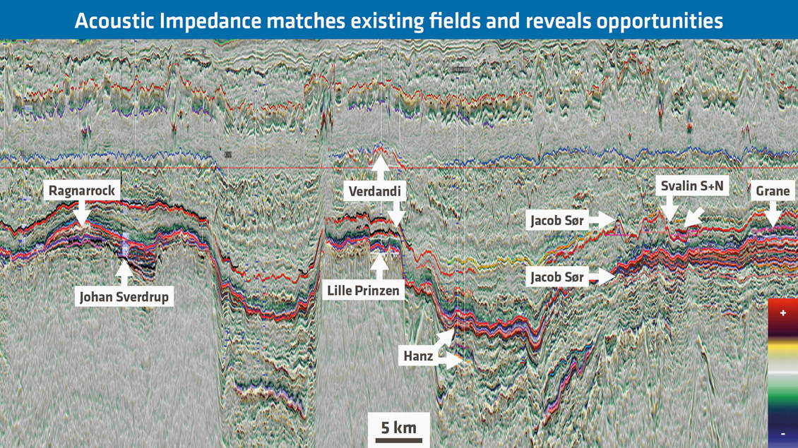
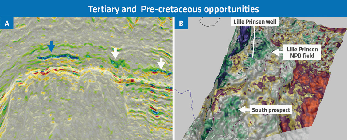
PGS has recently acquired and processed an innovative multi-azimuth multisensor survey in the prolific South Viking Graben, Norway. The dataset delivers reliable attributes for accurate reservoir characterisation. This area has provided numerous successes in multiple plays over the past decade and more recently the focus is on potential near-field opportunities. This quantitative interpretation project examines the various Tertiary to Permian reservoir levels using GeoStreamer X data combined with many wells present in and around the area of interest. For the latter, an interactive rock physics modelling product (PGS rockAVO) has been used, enabling a rapid assessment of the elastic property variation as well as the prestack seismic response to changes in reservoir properties (such as, porosity, saturation and volume of clay). By integrating this new dataset with regional well information, many of the exploration and near-field exploration challenges can be addressed. The evaluation of reservoirs and trapping styles of existing fields and discoveries is now possible with this unique dataset and additional opportunities can be revealed. GeoStreamer X is a broadband multi-azimuth acquisition and state-of-the-art depth-imaging solution. Here we demonstrate the suitability of the dataset for reservoir characterisation by delineating near-field exploration opportunities and providing better reservoir understanding in the South Viking Graben, Norway. The case study area is from the South Viking Graben, offshore Norway. Major fields are situated in this area, comprising several stratigraphic intervals (Figure 3): Eocene – Balder sands, Palaeocene – Heimdal sands (Grane, Jacob, Svalin, North and South and Verdandi), Upper Jurassic – Draupne (Jacob Sør and Hanz field), Late Cretaceous – Chalk Tor formation (Ragnarrock), Late Triassic to Mid-Jurassic (Ivar Aasen), Late Triassic to Early Cretaceous sandstone (Edvarg Grieg), Upper Jurassic intra-Draupne sandstone (Johan Sverdrup). More recent discoveries include the Lille Prinsen, drilled in 2018, which encountered various hydrocarbon intervals in the Eocene (Grid sand), Palaeocene (Heimdal sand) and Permian (Zechstein Group). The GeoStreamer X multi-azimuth (MAZ), multisensor acquisition was designed to overcome diverse and complex imaging challenges. In 2019 two new azimuths were acquired using a 12 × 6 km × 85m high-density GeoStreamer spread, including two 10 km-long streamers for improved Full Waveform Inversion (FWI), and a wide-towed triple source configuration (225m separation between the outer source arrays) to deliver reliable near-offset coverage in the 50–125m offset range. This seismic survey provides richer azimuth/offset information and illumination below and above the intervals of interest. These two additional azimuths are complementary to the existing reprocessed narrow-azimuth multi-client broadband GeoStreamer survey acquired in 2011 and together provide an azimuthally diverse dataset. The multi-azimuth dataset was subjected to a complex and rigorous prestack depth migration sequence with the main processing steps summarised below: Seismic interpretation has been conducted over the whole area based on this multi-azimuth broadband seismic and calibrated with 11 available wells. A regional interactive rock physics modelling product was further developed (PGS rockAVO) and used to better understand the elastic properties response to changes of the reservoir properties (e.g., VClay, Porosity) over the various intervals of interest. The expected AVA responses for the main reservoirs are: Class II/IIp AVO for the Tertiary Heimdal sands with hydrocarbons (Lille Prinsen, 16/1-29S), and Class I/II for the Upper Jurassic Draupne sands (Hanz, 25/10-8) and for the Permian Zechstein carbonate over Lille Prinsen side-track (16/1-29ST2). For the Heimdal sands in particular, the reservoir presents the following elastic properties characteristics: very weak acoustic impedance and strong Vp/Vs response rendering-in-effect. This reservoir is almost invisible on the near-angle stack but visible on the far and ultra-far angle stack, requiring accurate prestack processing and conditioning to preserve the Class II/IIp response in presence of hydrocarbons. The prospect definition is extremely challenging without a detailed AVO understanding and careful processing. The AVA responses were later confirmed by the well-to-seismic tie. Additionally, Reservoir Oriented Processing (ResOP) was performed using all azimuthal sectors (6) and angle stacks (4) with the focus on the main reservoirs and including: spectral harmonisation, de-noise, low frequency enhancement, multi-angle-azimuth time misalignment correction and the estimation of the isotropic / anisotropic gradient and intercept. One of the main outcomes of this targeted seismic data conditioning has been a distinctive broadband wavelet (3Hz to 80Hz bandwidth in the Eocene/Palaeocene interval) with very low side-lobe energy and presenting all the broadband wavelet characteristics (prestack and per azimuth). The seismic quality provides excellent well-to-seismic ties in all azimuths and associated angle stack directions. The statistics show an average cross-correlation of 80–85% in all azimuthal/angle directions for 10 wells. The AVO class observed at the various reservoir levels from the wells have all been confirmed. The GeoStreamer X data quality has enabled the resolution of substantially more stable gradient impedance (Figure 4a) and now provides a clean, and continuous interpretation at the Heimdal sand level, accurately delineating the anomalies and opening-up additional near-field exploration opportunities (white arrows). The well track represented is the Lille Prinsen gas discovery at the Heimdal level (blue arrow). This multi-azimuth multisensor quantitative interpretation provides very interesting results for the deeper reservoirs. Few additional wells have been drilled following the Lille Prinsen discovery to examine the potential in the deeper stratigraphic intervals such as Jurassic sandstones and the Permian. Based on the elastic attribute extraction and the pre-Cretaceous interpretation (Figure 4b) there are some clear indicators of hydrocarbon presence at the Upper Jurassic and Zechstein level. These anomalies are of reasonable size and could represent interesting near-field exploration potential. It has been demonstrated how an innovative acquisition set-up with a wide-towed source, azimuth diverse broadband seismic dataset has overcome the main exploration challenges in the prolific Southern Viking Graben and delivered a significantly improved understanding and characterisation of shallow to deep reservoirs. Leads and opportunities suitable for near-field exploration have been mapped using an integrated quantitative interpretation workflow.
GeoStreamer X delivers near-field multi-azimuth dataset for accurate lead characterisation, South Viking Graben, Norway
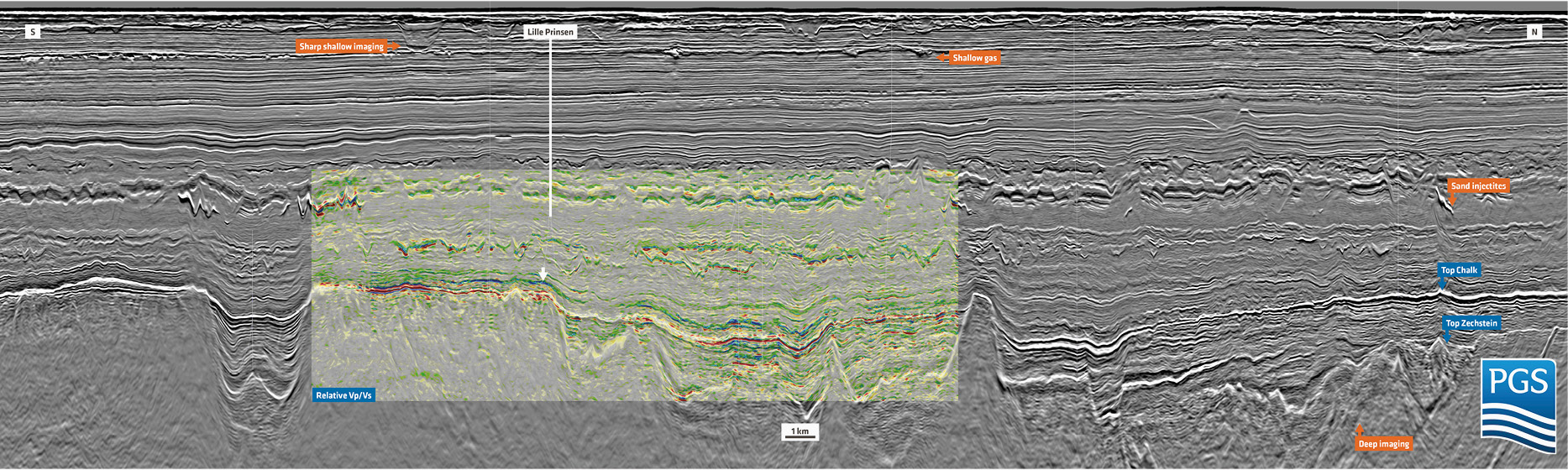 Figure 2: This full stack GeoStreamer X PSDM line runs through the main discoveries and fields in the South Viking Graben. In addition to the seismic display (in grey colour scale) a relative Vp/Vs section is overlaid. This attribute has been extracted from all azimuths and from the isotropic gradient and intercept estimation. The relative Vp/Vs highlights some key discoveries in the area such as Verdandi and Lille Prinsen in the Tertiary, characterised by a low Vp/Vs (blue colour), and Hanz, in a more downdip situation encountering hydrocarbons in the Upper Jurassic level. Additionally, this elastic attribute overlay highlights both the injectites and the so-called V-brights in the Grid formation extremely well.
Multi-Azimuth, multisensor, quantitative interpretation case study: South Viking Graben, Norway
Multi-azimuth imaging in a nutshell
Latest seismic and quantitative interpretation reveals new insight
Near-field opportunities revealed with GeoStreamer X dataset
Related Articles


