
The Red Rocks of South Pembrokeshire
The rocks which form the beautiful cliffs and beaches of south Pembrokeshire give a snapshot into the Variscan Orogen of south-west Wales.
From a geological perspective the county of Pembrokeshire in south-west Wales is unique in the British Isles in that its fully exposed, magnificent cliff coastline (accessed from the Pembrokeshire Coastal Path) transects two orogenic fold belts; the Caledonian and Variscan. These preserve rock sequences ranging in age from Neoproterozoic to Late Carboniferous, spanning a time period of some 250 Ma. North and South Pembrokeshire are divided by a line of geological, historical and language significance known as the Landsker, which runs broadly east–west from Narberth to the coast of St. Brides Bay at Newgale.
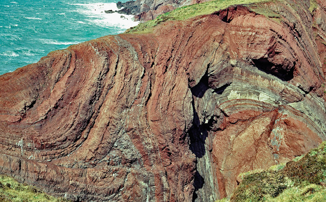
Figure 1: Variscan mesofold anticinal–synclinal, asymmetric couplet, as viewed to the west, on the southern limb of the Pembroke Syncline at Cobblers Hole, Dale Peninsula, south of the Ritec Fault. © Gareth George.
South Pembrokeshire records a splendid cross-section through the Mid- to Upper Palaeozoic sedimentary sequences contained within the east-south-east to west-north-west Variscan Orogenic Belt. This is enhanced by the presence of major long-lived, dip-slip faults and thrusts, including the Benton/Johnston Thrusts, the Musselwick and Wenall Faults, and in particular the Ritec Fault (Figure 2). These synsedimentary faults were important in controlling the location of depocentres for the accumulation of the Siluro-Devonian sedimentary sequences during the Mid-Palaeozoic.
Additionally, the Variscan deformation generated large scale macrofolds, such as the Marloes/Winsle Inliers and the Burton Anticline, north of the Ritec Fault, and the Ridgeway and Castlemartin-Orielton Anticlines with the intervening Pembroke Syncline south of it. The macrofolds contain parasitic mesofolds on their flanks, often in couplets (Figure 1) and commonly with east and west plunges in excess of 20o. The folding is associated with both right-lateral and left-lateral-slip (wrench) faulting and has become a classic study area for structural geologists on conjugate wrench fault analysis (Hancock et al., 1981). In addition to the faulting, the 2–5 km amplitude of the Variscan anticlines has culminated in a modest horizontal tectonic shortening of between a few to several kilometres compared with about 22 km of cross-strike width to the region in the present day (Dunne, 1983).
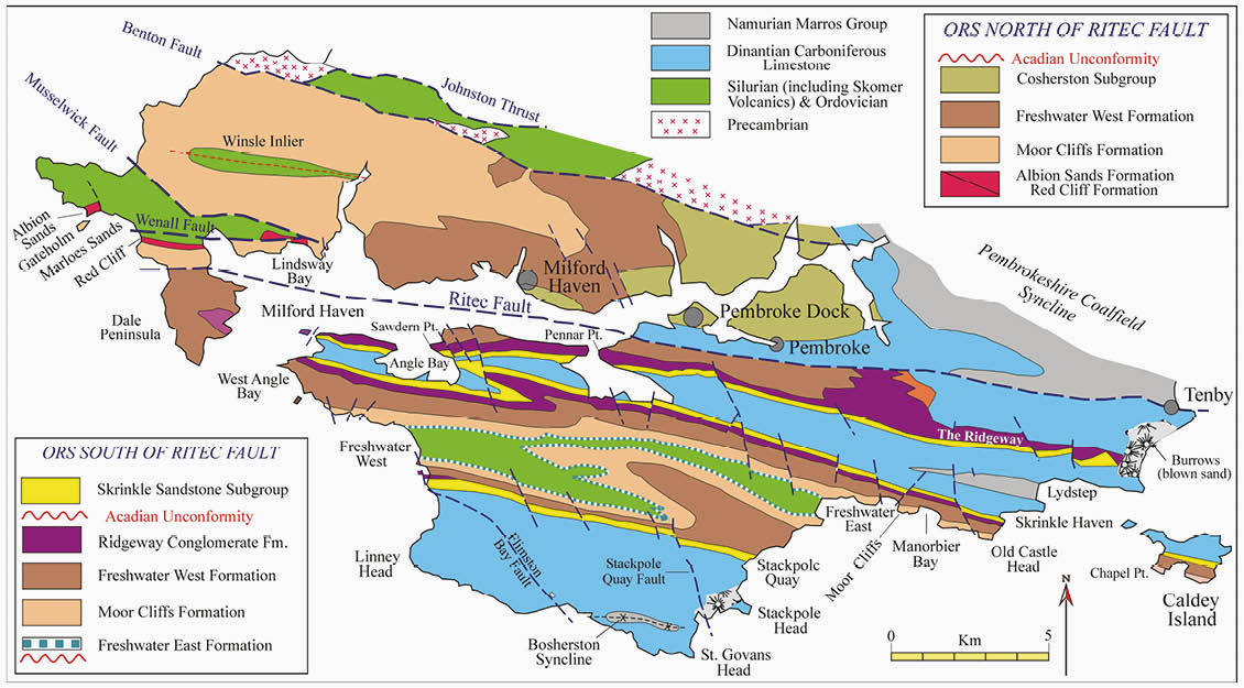
Figure 2: Geological Map of south Pembrokeshire showing Mid–Upper Palaeozoic stratigraphy and major Variscan structures. Source: Brian Williams, from Williams et al., 1982
The Welsh Old Red Sandstone
The Pembrokeshire ‘Red Rocks’ are of Siluro-Devonian age (427–358 Ma) and referred to as the Old Red Sandstone (ORS) magnafacies. They are magnificently exposed within the Variscan Foldbelt in the Marloes-Cosheston Block, the Pembroke Peninsula and on the islands of Skokholm, Gateholm and Caldey. South Pembrokeshire comprises the westernmost outcrops of the ORS in the Anglo-Welsh Basin. The ORS magnafacies dominates Central South Wales to the Welsh Borderlands; an outcrop area of over 20,000 km2. The basin-fill sequence ranges in thickness from 2 km in the Welsh Borders to between 2.8 and 4.4 km preserved in the Variscan Foldbelt of the area (Williams et. al., 2004).
Volumetrically, the bulk of the South Wales ORS is dominated by the Lower ORS, deposited on the southern margins of the ORS Continent, a land mass that formed by Mid-Silurian times (c. 430 Ma) due to the closure of the Iapetus Ocean and the plate amalgamation of Laurentia with Baltica and the microcontinent Avalonia. Due to its geographic position on the ORS Continent, the Lower ORS Anglo-Welsh basin fill comprises predominantly continental red-bed sediments that record differing depositional architectures reflecting variations in subsidence and tectonic history, provenance and depositional mechanisms. The Lower ORS sequence in South Pembrokeshire ranges in age from basal Ludlow (427 Ma) to Mid-Emsian (400 Ma); it has a transitional lower contact with marine Silurian rocks north of the Ritec Fault and an unconformable contact on marine Silurian rocks in the Pembroke Peninsula. The Lower ORS comprises a broadly upward-coarsening sequence, both north and south of the Ritec Fault; its depositional termination being designated by a major unconformity generated in Mid-Late Emsian times by the Acadian deformational event. No Middle Devonian rocks are present in the Anglo-Welsh Basin.
Oldest ORS: Marloes Inlier
The Marloes Peninsula provides some of the most spectacular viewpoints from the coastal path (Figure 3a). The Siluro-Devonian sequence that makes up the Marloes Inlier is fault-bounded to the north and south by the Musselwick and Ritec Faults, respectively. Within this area, grey Silurian shallow marine sediments of Wenlock age (c. 430 Ma) pass transitionally into red sandstones of the Red Cliff Formation, the change in colour marking the incoming of fluvial facies characteristic of the Lower ORS. This 50m thick succession also contains incipient calcretes (pedogenic carbonate soil horizons), burrows and mudrocks that have yielded Ludlovian palynomorphs, or spores (Allen and Williams, 1978; Hillier and Williams, 2004). These distal, tidally-influenced sediments of southerly provenance are abruptly overlain – probably with a hiatal surface – by the 100m thick Albion Sands Formation, comprising multi-storey and multilateral very coarse-grained lithic arenites that are extensively channelled and trough cross-bedded (Figure 3b) facies contain volcanic detritus, transported from a westerly (Avalonian) source area by sediment-charged rivers with low sinuosity braided profiles.

Oldest ORS: Marloes Inlier The Marloes Peninsula provides some of the most spectacular viewpoints from the coastal path (Figure 3a). The Siluro-Devonian sequence that makes up the Marloes Inlier is fault-bounded to the north and south by the Musselwick and Ritec Faults, respectively. Within this area, grey Silurian shallow marine sediments of Wenlock age (c. 430 Ma) pass transitionally into red sandstones of the Red Cliff Formation, the change in colour marking the incoming of fluvial facies characteristic of the Lower ORS. This 50m thick succession also contains incipient calcretes (pedogenic carbonate soil horizons), burrows and mudrocks that have yielded Ludlovian palynomorphs, or spores (Allen and Williams, 1978; Hillier and Williams, 2004). These distal, tidally-influenced sediments of southerly provenance are abruptly overlain – probably with a hiatal surface – by the 100m thick Albion Sands Formation, comprising multi-storey and multilateral very coarse-grained lithic arenites that are extensively channelled and trough cross-bedded (Figure 3b) facies contain volcanic detritus, transported from a westerly (Avalonian) source area by sediment-charged rivers with low sinuosity braided profiles. © Kevin Privett.
Figure 3b: Classic view of the Albion Sands Formation composed of coarse-grained, poorly sorted and trough cross stratified multistorey/multilateral channel sand bodies. © Gareth George.
Thus, the Marloes Inlier preserves the oldest representative ORS facies seen anywhere in southern Britain, and may only be matched in age by some ORS sediments deposited in intermontane basins in north-east Scotland within the heart of the ORS Continent.
The Pembroke Peninsula: ‘Red Rocks Country’
The Lower ORS of South Pembrokeshire has recently been stratigraphically re-assigned to the Daugleddau Group (Barclay et.al., 2015), which ranges in age from the Silurian Ludfordian (427 Ma) to the Lower Devonian mid- Emsian (400 Ma). Continental deposits of this time period are beautifully displayed throughout the Pembroke Peninsula, in repeated outcrops produced by the large amplitude Variscan folding.
The two main localities in the Pembroke Peninsula in which these amazing suites of rocks can be studied in detail are Freshwater West, a dip section on the vertical southern limb of the Castlemartin Anticline, and between Manorbier Bay and Skrinkle Haven, an extraordinary strike section through the Pridolian rocks (420 Ma) on the vertical southern limb of the Pembroke Syncline (Figure 2). The superlative reference section at Freshwater West is described in detail below, with links to other Lower ORS localities within the Marloes – Cosheston Block and the Pembroke Peninsula.
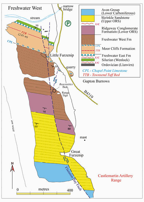
Figure 4: Geological map of Freshwater West: note the trace of the Flimston Bay Fault. Source: Brian Williams, from Williams et al., 1982.
Arguably the finest continually exposed section through Mid-Palaeozoic rocks in southern Britain! The sequence, which is easily accessed (depending on tides), displays the entire ORS succession together with patchy outcrops of Lower Ordovician black, deepwater graptolitic shales, which form the core of the Castlemartin Anticline (Figure 4). An attenuated shallow marine, 11m thick, Silurian sequence, of Wenlock age, rests with marked unconformity on the Ordovician mudrocks, and is in turn overlain by the basal unconformity and conglomerates of the Lower ORS. This is the ORS section most visited by geologists and students in the UK because of its completeness and the superb, wave-polished exposure of all the ORS formations (Williams et.al., 1982; Williams and Barclay, 2005).
Before proceeding to the foreshore, a stunning, rock platform overview of the steeply-dipping and south-younging southern limb of the Castlemartin Anticline is best appreciated from the road which runs between 10 – 35 m above the section (Figure 5). From the view point, at low to half tide, the rock platform is seen to be dissected by a major Variscan right-lateral (dextral) fault, the Flimston Bay Fault, which bisects the entire section with a displacement of 120 – 155m. The fault generated a major gash zone in the headland of Great Furzenip, forms the stack of Little Furzenip, then disappears in a myriad of small splay faults just north of the stack, resulting in its absence on the northern limb of the Castlemartin Anticline (Figure 4). The Flimston Bay Fault reveals an increased right-lateral displacement to over 1 km as it is traced in a south-easterly direction towards Bosherston before it leaves the Pembroke Peninsula (Figure 2).
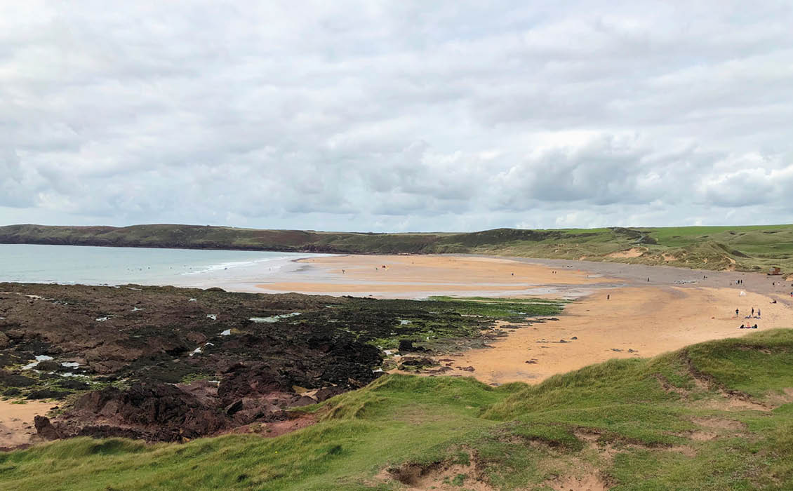
Figure 5: Freshwater West beach looking north-west from Little Furzenip. © Jane Whaley.
Basal Conglomerates: Freshwater East Formation
To the north of Little Furzenip, the late Wenlock-aged, shallow marine Gray Sandstone Group is unconformably overlain, with a c. 6 Ma time gap, by the basal unit of the Old Red Sandstone. This is the Freshwater East Formation (FEF) (Williams et.al., 1982), which takes its name after its type locality some 15 km along strike in the lovely bay of Freshwater East, where it is 50m thick but is attenuated to only 18m at Freshwater West.
The formation comprises conglomerates in its lower part, succeeded by fine-grained sandstones. The green to dark grey conglomerates are composed of framework-supported cobbles – pebbles with massive to flat-bedded internal fabrics (Figure 6). Clasts, up to 450 mm in size, are of quartzitic and lithic sandstones with vein quartz and olive green mudstones, reminiscent of underlying Silurian strata. The upper finer grained lithofacies have yielded lingulids, plant remains, arthropod tracks, ostracoderm fragments and Pachytheca.
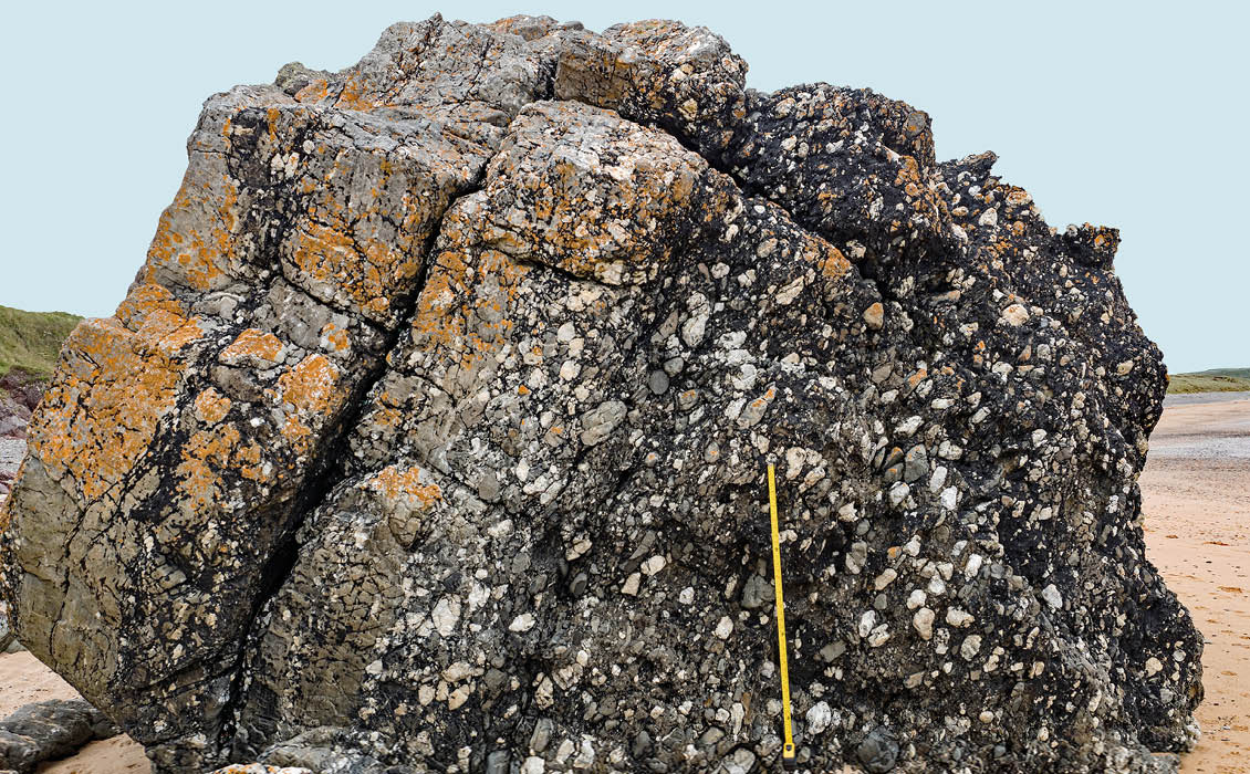
Figure 6: Basal conglomerate of the Freshwater East Formation at Gravel Bay on the north side of Freshwater West. Note the massive to flat bedding and long-axis orientation of clasts vein quartz and sandstone clasts. © Gareth George.
Recent research (Hillier et.al., 2019) has identified the FEF on Gateholm Island and allows its correlation across different fault blocks for the first time. Its interwoven relationship with the Moor Cliffs Formation on the island has suggested that the FEF represents part of a simple incised valley fill system. The incision was basin-wide, structurally-controlled, up to a depth of 60m and partly filled with conglomerates deposited from south-east-flowing braided rivers.
Into the Mud: Moor Cliffs Formation
The Moor Cliffs Formation (MCF) is named after the excellent strike sections that crop out in West Moor and East Moor cliffs near Manorbier (see Figure 9a). (Williams et.al., 1982). The dip section at Freshwater West displays all its major sedimentological attributes. It has a transitional contact with the underlying FEF, crosses the Silurian/Devonian boundary in age and varies in thickness across the Ritec Fault from 120m at Freshwater West to 371m in the Marloes-Cosheston Block (Williams and Hillier, 2004).
Although the MCF is over 70% mudrock, this fine-grained deposit exhibits an array of fascinating microfacies that help in understanding its depositional setting within a tropical dryland alluvial and coastal plain environment subject to repeated and prolonged emergence and carbonate soil formation (calcretes) of varying maturities (Figure 7) ( Love and Williams, 2000; Marriott and Wright, 2004; Williams and Hillier, 2004). In addition to the mudrock microfacies, the formation is punctuated by multi-storey, exotic, fluvial sandstone packages and individual sheet sandstones with high width-depth ratios (see Figure 11); together with major volcanic event horizons (see below) and a multilayer calcrete complex at the top of the MCF.
Figure 7: Moor Cliffs Formation mudrocks with bowl-shaped, 3m-thick, mature calcretised profile at Freshwater East, where the rocks are vertical and younging right to left. © Gareth George.
The mudrock microfacies have been studied in detail by Marriott and Wright (2004), who identified several types: pedified (calcretized) units (Figure 7); burrowed horizons; brick-red massive units often pelleted; and both inclined and non-inclined heterolithic units. From these varieties the suggested model is one of a two-stage dryland system where the main trunk streams were anastomosing, though ephemeral. Varying flood events, dust storms, pedified and ponded areas all contributed to this array of mudrock depositional styles. Conversely, the exotic sandstone bodies, both multi- and single-storey, in the lower and upper parts of the MCF demonstrate dramatic mega-flood events from a northern hinterland; these are coarse-grained litharenites, locally pebbly with plane-bed or cross-bedded internal structures, as the rate and volume of the sediment load commonly generated soft sediment deformation. The sheet-like geometries (Figure 8) of these sandstones, with their erosive bases and very sharp tops, can be clearly seen in strike section between Manorbier and Old Castle Head (Figure 9e).
Figure 8: Very coarse grained to pebbly sheet sandstone with erosive base and sharp top developed within massive incipient calcretised mudrocks of the Moor Cliffs formation, north side of St. Bride’s Haven, Marloes-Cosheston Block. © Brian Williams.
Explosive Events: Townsend Tuff Bed
One of the most important discoveries in the ORS of the Anglo-Welsh Basin in the last 40 years was of a key stratigraphic marker horizon – the Townsend Tuff Bed (TTB) (Figure 9b) within the Moor Cliffs Formation. (Allen and Williams, 1981; 1982). This horizon, the products of huge volcanic events, were subsequently mapped throughout the entire basin from Skokholm Island to Ludlow, and outcrop area of over 20,000 km2. This tuff has a very distinctive internal stratigraphy (Figure 9c), which facilitated ease of correlation over such an extensive area.
The TTB is one of several volcanic ash fall horizons recorded in the MCF; most are minor, thin impersistent horizons but two others are of importance in South Pembrokeshire and beyond; the Rooks Cave Tuff and the Pickard Bay Tuff. The former occurs some 40m below the TTB and is best seen in the Manorbier to Conigar Pit strike section (Figure 9e). The Pickard Bay Tuff, which is found throughout the basin, occurs some 15–30m above the TTB and about 100m below the Chapel Point Limestone Member that marks the top of the Moor Cliffs Formation.
The TTB comprises three superimposed units relating to separate eruptions (Falls A – C, Figure 9c)and preserve a thickness between 1 and 4m. Generally, it is thinner to the west where depth of burial of the ORS was greater and Variscan tectonic flattening more pronounced. Fall A is the thinnest unit (max. 0.69m) with a very sharp upper surface that is covered in a variety of trace fossils (Marriott et.al., 2009); Fall B contains internal bedforms testifying to deposition in a subaqueous setting (Figure 9b) and is the thickest, up to 3.20m. It is always capped by an erosion surface. Fall C, with a maximum eroded thickness of 2.10m is the only ash fall in the bed not to be capped by a silicified dust tuff (porcellanite).
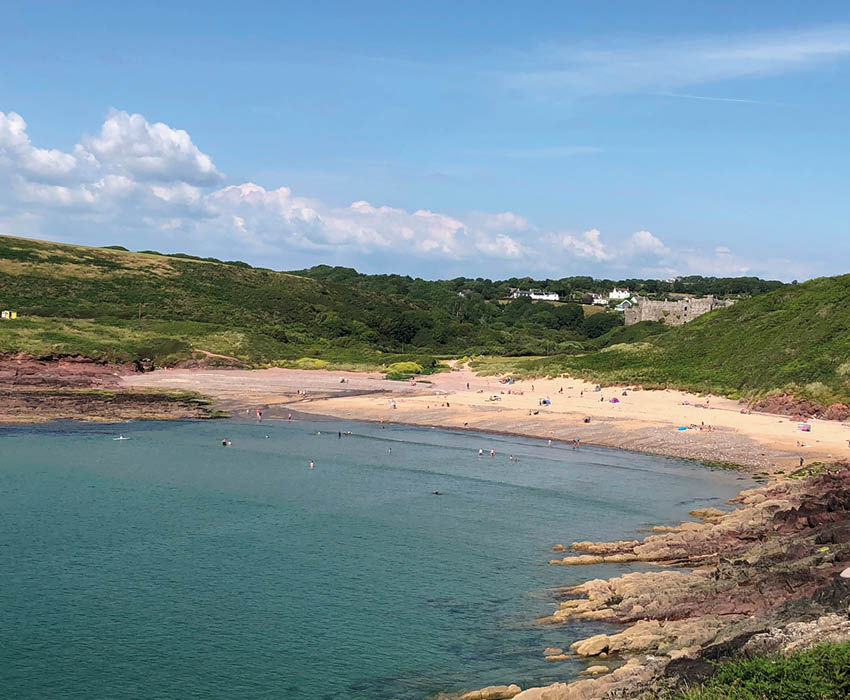
Figure 9a: Manorbier Bay, looking north-east toward Manorbier Castle. A well as fantastic rocks, there are many castles and other monuments to visit in Pembrokeshire. © Jane Whaley.
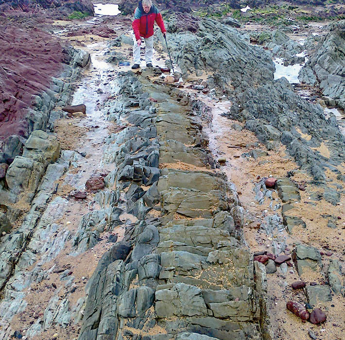
Figure 9b: The 2.29m-thick Townsend Tuff Bed completely exposed just north of Little Furzenip, Freshwater West, after storms during January 2018 (Prof. Brian Williams for scale). © Liz Wild.
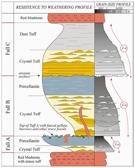
Figure 9c: A schematic profile of the TTB illustrating the main sedimentological features. Brian Williams & Gareth George (2021).
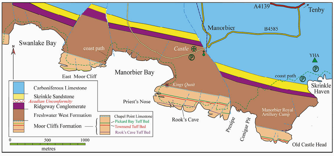
Figure 9d: Geological map along the coast from Swanlake Bay to Old Castle Head. Brian Williams et.al. (1982).

Figure 9e: Strike section photograph of the Moor Cliffs Formation from Priest’s Nose (Manorbier) to Old Castle Head; the Rooks Cave Tuff follows the line of the hollow and is interbedded with profusely calcretised mudrocks and sheetflood sandstone. © Kevin Privett
The mineralogy and diagenesis of the TTB indicates its origins in a series of volcanic explosions, when large volumes of windblown ash was dispersed over a very wide area. It is suggested that, over the known outcrop area, the volumes of ejecta for Falls A and B would equate with a tephra fallout of 5 – 10 km3. Episodic deposition is suggested by internal bedforms and trace fossils, both within and on surfaces of the main falls. A regionally developed scoured surface at the top of Fall B is interpreted as a tsunami horizon following the second major eruption. The mineralogy and diagenetic features of these ash falls suggest that the volcanic vent(s) were situated approximately 250 – 800 km to the north-west and possibly in Laurentia, on the other side of the Iapetus suture.
Fall A of the TTB has recently been radiometrically dated as 420.03 +/- 0.63 Ma (Hillier, 2019 pers. com.), which is well within the error of the generally accepted age of the Silurian/Devonian boundary of 418.1 +/- 3 Ma; thus the bed is a good proxy for this boundary within the ORS of the Anglo-Welsh Basin.
The widespread nature of both the Townsend and Pickard Bay Tuffs, over an outcrop area of 450 kms2, presents a correlation window for alluvial architectural analysis over a narrow stratigraphic interval of 15 – 30m. A very detailed analysis is afforded by six laterally persistent tuff markers within this interval, which has helped distinguish both aggradational and incisional fluvial sand bodies, the latter with possibly some tidal influence (Allen and Williams, 1982).
The Rocks Cave Tuff Bed is very well exposed along the magnificent strike section between Priest’s Nose at Manorbier and Old Castle Head (Figure 9e). It is of variable thickness (0.5 – 2.5m) due to the irregular surface on which it was deposited (Love and Williams, 2000), which is likely to have comprised floodplain ponds and inter-pond areas with a high density of infaunal burrowing organisms (Marriott et.al., 2009).
Basin Shutdown: Chapel Point Limestone Member
Of stratigraphic importance across the entire Anglo-Welsh Basin is the development of the Chapel Point Limestone Member (CPLM), named after its superb type section on Caldey Island (see Figure 10). It comprises a thick (up to 20m), stacked sequence of calcretised vertisols of varying maturity approximately 100m above the TTB (Williams and Hillier, 2004). It is also very well displayed at Freshwater West at Little Furzenip and again as a massive stacked limestone at Llansteffan, about 50 km to the north-east.
These calcretes reflect a period of significant geomorphic stability and tectonic quiescence across the whole Anglo-Welsh Basin. It marks the top of the MCF; its upper surface is extremely abrupt and coincides with a profound change in lithofacies, faunal types, depositional environment and sediment provenance (Allen, 1985), The thick development of calcrete was created by reduced subsidence rates and erosion, leading to high residence periods for soil formation, and its development may indicate a period of extended aridity. However, it is also possible that parts of the former Lower Palaeozoic Welsh Basin and Irish Sea areas were being tectonically inverted at this time, with palaeoflows in fluvial channels from the north and north-west (Allen, 1985). Whatever the main driving force, the basin was shut down and not receiving new sediment supplies for a substantial period of time, probably over 100,000 years. Thus, the top of the CPLM is a significant hiatal surface in the evolving story of the Lower ORS basin fill.
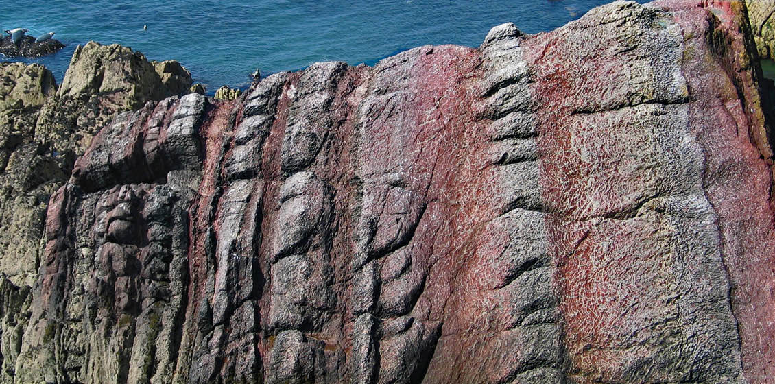
Figure 10: Chapel Point Limestone Member at Chapel Point, Caldey Island, composed of a well-defined upward thickening sequence (10m) of stacked calcrete vertisols, with pseudo-anticlinal structures, hosted in red mudrocks. Top left – seals for scale. © Gareth George.
The Evolving Fluvial Style and Architecture: Freshwater West Formation
The Freshwater West Formation (FWF) varies in thickness from 1,000 to 1,500m north of the Ritec Fault and 346-580m south of the fault, where its minimum thickness is at the type section. Originally named by Williams (1978) it comprises two distinctive facies associations: the Conigar Pit Sandstone Member (CPSM) and the Rat Island Mudstone Member (RIMM) (Williams, et.al., 1982) and is mid Lochkovian in age, conforming to the MN Spore Zone assemblage extracted from the CPSM at Freshwater West (Higgs, 2004). At the type locality, the formation is beautifully displayed by virtue of sublime wave-polished surfaces in the rock foreshore, within the south-younging limb of the Castlemartin Anticline (Figures 2 and 4). Other sections where the formation is found in superb outcrops include from Swanlake to Manorbier Bay, Red Berry Bay on Caldey Island, Gelliswick Bay, near Milford Haven and farther east at Llansteffan, Carmarthenshire.
An important historical note is that the Conigar Pit sandstones at Manorbier Bay provided one of the first analyses and interpretation of upward-fining cycles as the deposits of meandering river systems (Allen, 1963). Since those early observations, detailed research has revealed that the CPSM, above its hiatal contact with the MCF, displays a punctuated upward-coarsening motif of varying fluvial styles and architecture (Williams and Hillier, 2004; Marriott and Hillier, 2014) (Figure 11).
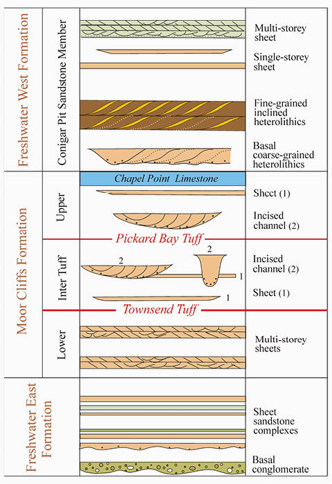
Figure 11: Variable fluvial architecture within the Lower ORS of the Pembroke Peninsula; note the 4-fold fluvial sandstone styles in the Chapel Point Limestone Member. Brian Williams & Rob Hillier (2004).
Immediately above the FWF/MCF hiatal surface the basal sandstones are coarse grained and heterolithic with internal bedforms that show inclined bedsets. The sandstone bases are commonly very coarse grained to pebbly and show the first introduction of exotic detritus from a new northerly source area following the basin shutdown. Between the sandstone bundles the mudrocks are varicoloured with both biogenic and pedogenic destratification.
Traversing up-section, the second fluvial sandstone style is encountered; overlying low relief erosion surfaces draped with intrafomational conglomerates are fine-grained, upward-fining, inclined heterolithics with lateral accretion sets, the product of sluggish meandering rivers. Again, the intervening mudrocks are variously calcretised and bioturbated.
These packages are frequently interrupted by upward-fining sheet-flood units varying in style from relatively coarse-grained flat to planar cross-bedded sandstones with current ripple-laminated tops, to finer sandstones and siltstones with current ripples and laminated silt/clay couplets. These beds are commonly disrupted by very large burrows, up to a 20 cm in diameter and 2m in length (Allen and Williams, 1981). Previously referred to as Beaconites antarcticus (Allen and Williams, 1981) and now called Taenidium, these remarkable trace fossils are abundant in the CPSM and are ascribed to a now extinct group of arthropods known as Eoarthropleurids (Figures 12b and 12c).
The fourth style of fluvial architecture are multi-storey medium to coarse grained sandstone packages, up to 13m thick, in the CPSM at Freshwater West, and are sheet-like at the scale of these exposures. They contain many small-scale internal erosion surfaces, have extraformational conglomerates at their bases and are flat or cross-bedded on a large scale in sets over 1m in thickness; they are the product of lunate dunes migrating down braided river channels (Figure 12d). The extrabasinal conglomerates and medium to coarse grained sandstones that comprise these braided river channel and bar deposits also contain the first major occurrence of fish fragments including plates, spines and scales of pteraspids, traquairaspids, and onchids.
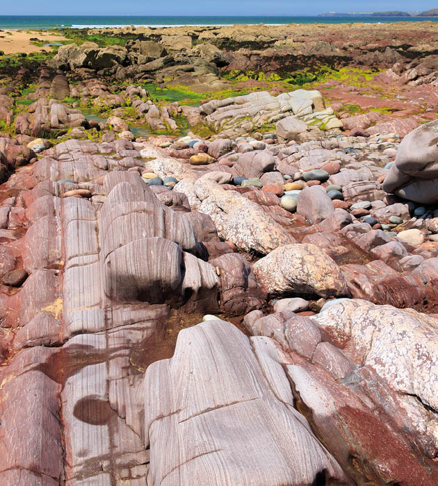
Figure 12a: Upward-fining sheetflood sandstones overlying calcrete in the FWF at Freshwater West. Sequences young right to left. © Kevin Privett.
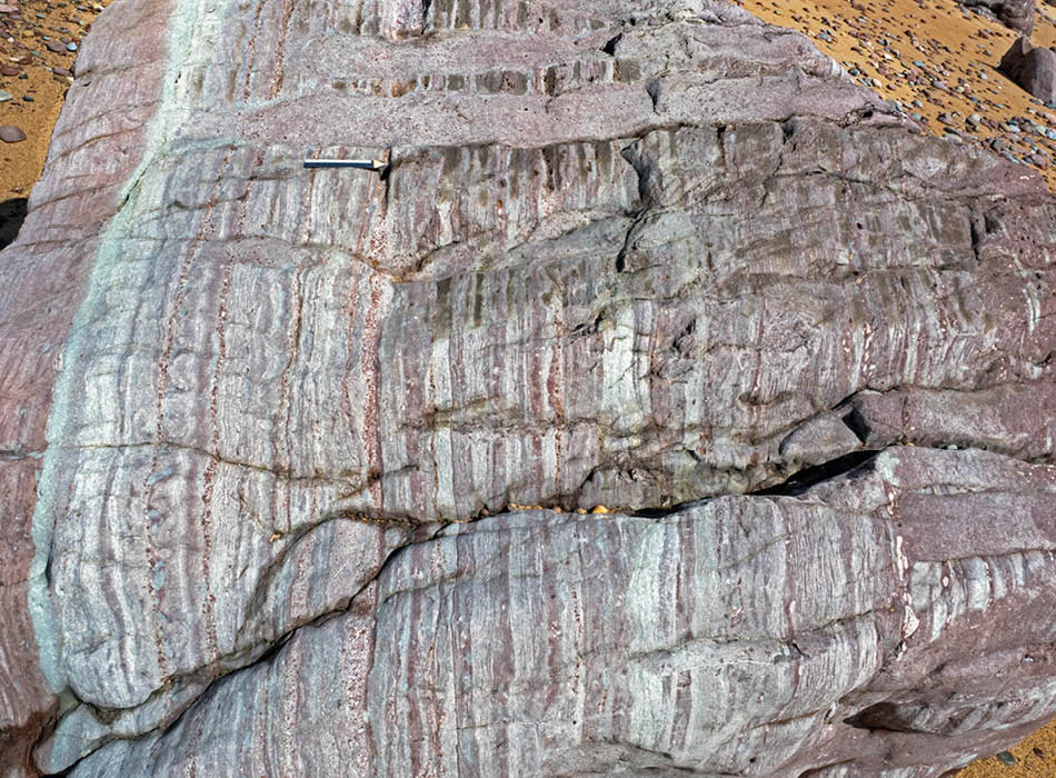
Figure 12b: Beaconites (Taenidium) burrows in CPSM (at 124m on Fig. 12), the way-up arrow is 12 cm. B Multistorey sandstone complex with large scale trough cross-bedding (c. 204–205m on Figure 13 in the braided river complex). © Gareth George.
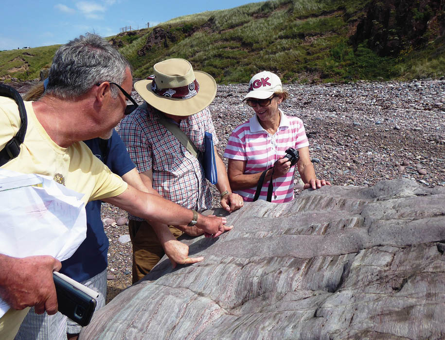
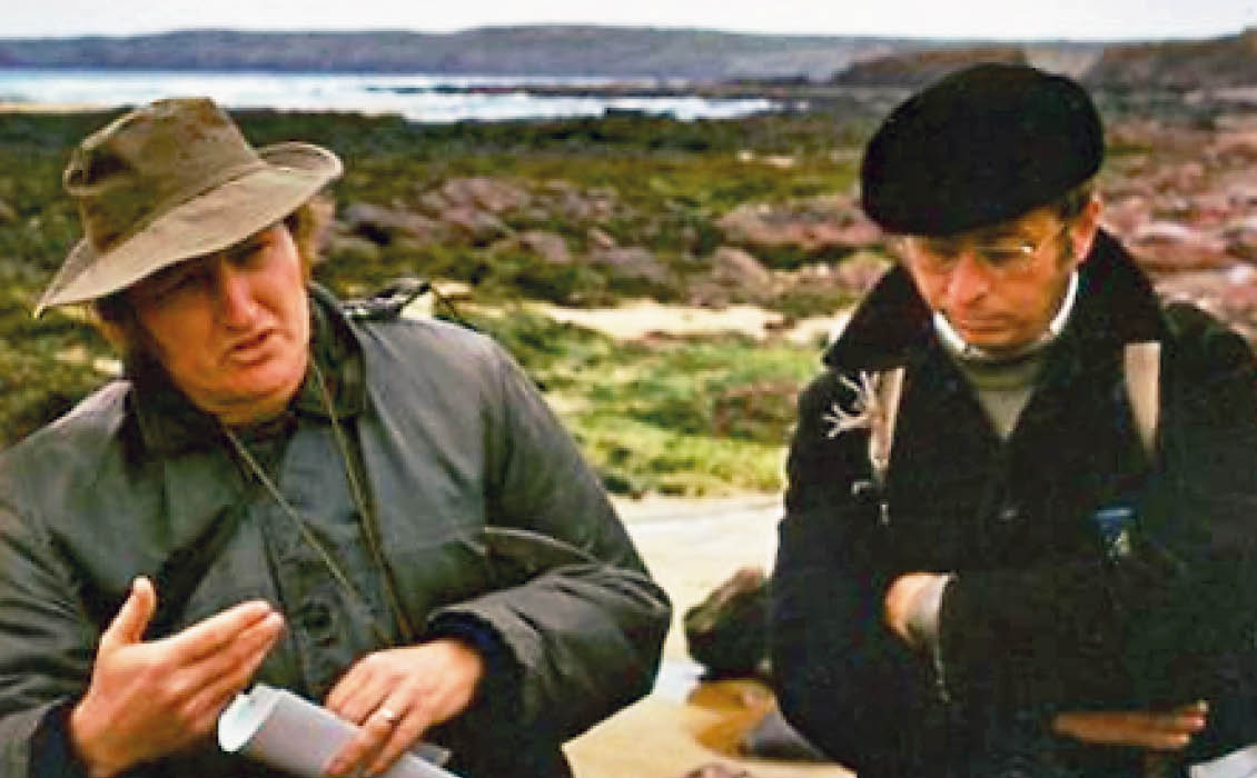
Figure 12c: Geologists (including the GEO ExPro Editor) discuss beaconites burrows. © Val Taylor.
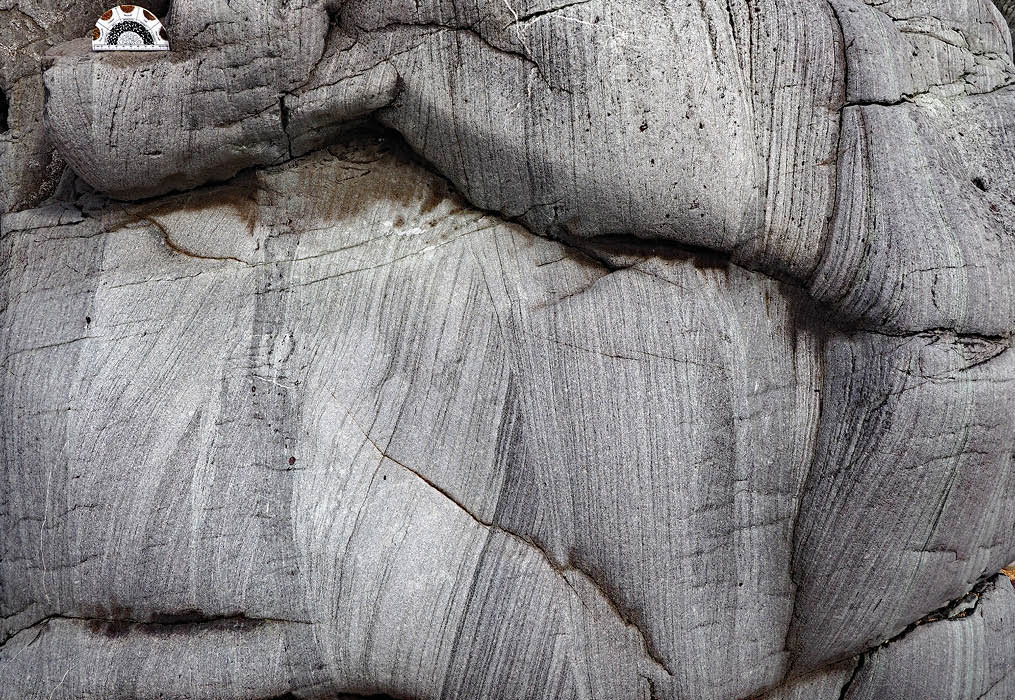
Figure 12d: Multistorey sandstone complex with large scale trough cross bedding [c. 204–205m on Fig. 12 in the braided river complex]. © Gareth George.
A detailed sedimentary log through 105m of the most spectacular part of the CPSM at Freshwater West is shown in Figure 13.
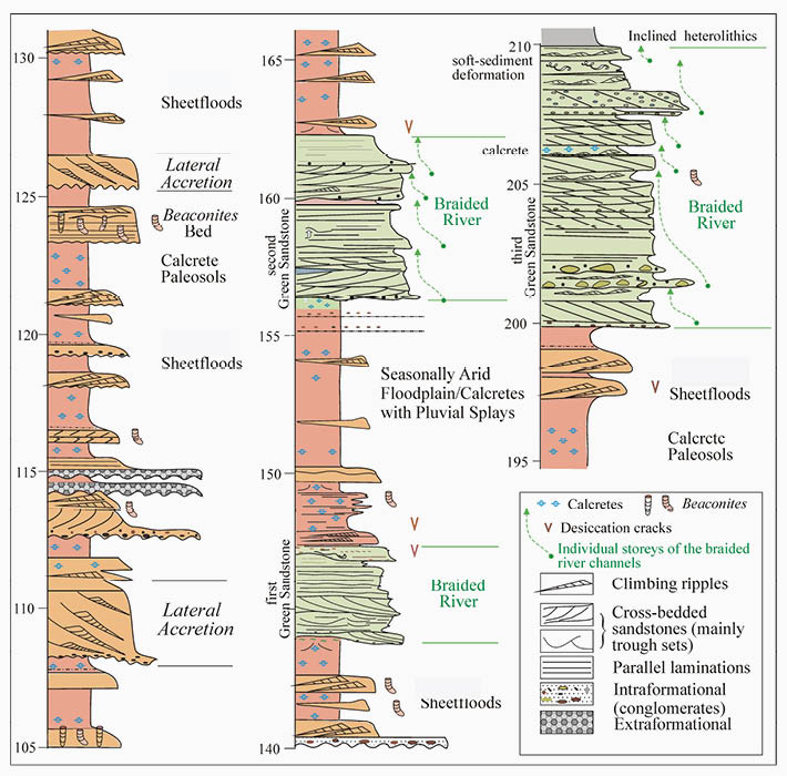
Figure 13: Sedimentary facies log through part (105m) of the Conigar Pit Sandstone Member at Freshwater West. (From Williams et. al., 1982 and Williams and George, 2021)
The topmost sequence of the FWF at Freshwater West is the 81m thick Rat Island Mudstone Member (RIMM). Named after Rat Island, off the Angle Peninsula, this mud-dominated unit is best seen where it has been studied in detail, in Manorbier Bay (Figure 9a) (Marriott et.al. 2005).
Although mainly mudrock the member reveals stacked cyclic packages of four facies lithotypes – intraclast conglomerate; heterolithics; pedified mudstone and mudstone. These occur in distinct upward-fining units some 2.5 to 5m thick. They represent ephemeral channel-zone deposits in which extensive reworking of palaeosols took place as clay-pellet bedload material. An analogy with the Channel Country of central Australia has been envisaged (Figure 14), as a depositional environment where anastomosing fluvial systems are associated with distal mud sheetflood deposits (Marriott et. al., 2005). Very close to the top of the RIMM at Freshwater West incursions of exotic detrital sand grains appear in the section. These grains comprise phyllite particles, observed here for the first time in the deposits of the Lower ORS in South Pembrokeshire. Hillier and Williams (2007) have taken this to be a precursor of the overlying Ridgeway Conglomerate Formation, with its southerly source, associated with the first pulse of the Acadian deformation event.
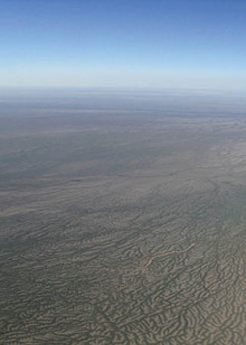
Figure 14: Channel country, central Australia, from the air. © Stuart Edwards, Wikipedia.
End of the Lower Old Red Sandstone
Initially described by Williams (1971) and reported in Owen et.al. (1971), the Ridgeway Conglomerate Formation (RCF) proved to be the first example of southerly-derived coarse sand to gravel grade sediment to be emplaced into the Anglo-Welsh Basin from a landmass then situated in the Bristol Channel area. The formation is only found in the Pembroke Peninsula, south of the Ritec Fault. Due to the lack of faunal, floral or dateable volcanic ash horizons, its age has been difficult to ascertain.
However, recent re-mapping of the Formation (Hillier and Williams, 2007) revealed a transitional contact with the underlying FWF of mid-Lochkovian age. Additional detailed research on the sedimentology and palynology of the Cosheston Group in the Marloes-Cosheston Block, north of the Ritec Fault (Thomas et.al., 2006) implied that the conglomerates pre-dated the Mill Bay Formation of the Lower Cosheston Group, thus indicating a Late Lochkovian to Early Pragian age for the RCF. (Note that the Upper Cosheston Group is non-palyniferous but probably extends from the Pragian to Early Emsian in age (pre the Acadian Orogenic Event).
The RCF at Freshwater West is 115m thick but thickens drastically into the Ritec Fault (e.g. at Sawdern Point to 387m), indicating its control on sedimentation. The conglomerate thins to the west and is absent on Caldey Island, where the Upper Devonian Skrinkle Sandstones overlie the Freshwater West Formation with marked unconformity. This thinning and overstep of the RCF is in part a reflection of the fan-like geometry of the conglomerate and the impact of the Acadian deformation event in the mid Emsian.
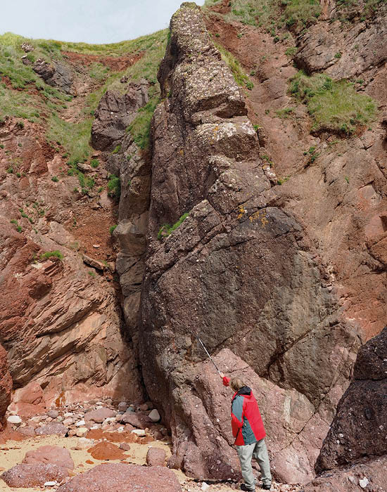
Figure 15: Thick petromict conglomerates in the RCF at Freshwater West; note clast size, variation and imbrication. © Gareth George.
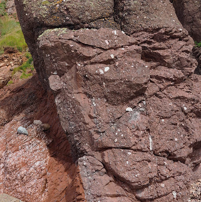
Figure 15: Thick petromict conglomerates in the RCF at Freshwater West; note clast size, variation and imbrication. © Gareth George.
The RCF outcrop at Freshwater West is the most proximal to its southerly source. The formation is broadly upward-coarsening and contains 11 petromict conglomerate bodies ranging from 0.6 to 9m thick. This facies makes up 30m of the Formation. They overlie erosion surfaces (Figure 15), are massive/flat to crudely cross-bedded and exhibit clast imbrication. The units are framework-supported, contain exotic clasts of quartz and lithic arenites (4 – 64 mm in size; locally up to 30cm); lithic wackes; siltstones and vein quartz with a sharp increase in phyllarenites higher in the section.
Other beds are matrix-supported with bright red, ill- sorted gritty mudstones with irregular seams and pods of outsize clasts. The sandstones are medium to very coarse-grained litharenites and phyllarenites that are massive and graded or cross-bedded and locally burrowed by Beaconites . As with many alluvial fans, the high volume of mudstone in the RCF are calcretised; some by pedogenic processes but many are groundwater calcretes displaying meniscus carbonate cements around clasts in the gravel facies (Hillier et al. 2011).
A half-graben topography initiated the deposition of the RCF in a hangingwall alluvial fan that was sourced from a Lower Palaeozoic/Late Precambrian hinterland in the present Bristol Channel area (Figure 16). The conglomerates were deposited by laterally extensive sheetfloods and bars in low-relief channels. Most of the sandstones were also of sheetflood origin, whereas the gritty mudrocks represent cohesive debris flows. Northward, the prograding fan interdigitated with axial, low gradient, high sinuosity fluvial channels. Finer grained sediments accumulated in the fan-toe and axial valley lakes. Calcrete development throughout the RCF in fan and axial valley facies indicate dryland, semi-arid conditions.
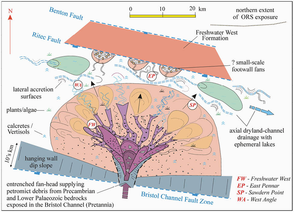
Figure 15: Alluvial fan tectono-sedimentological model for the Ridgeway Conglomerate Formation, Pembroke Peninsula (George, 2015, based on data from the authors cited in the text).
A Snapshot
The Freshwater West section in the Pembroke Peninsula provides an excellent snapshot into the Lower ORS Red Rocks of south-west Wales. To see such a variety of continental sedimentation responding to both climatic and tectonic changes from Late Silurian to end Lower Devonian times in one huge, fully accessible outcrop is quite remarkable. The story of red bed initiation on the southern margins of the newly-formed ORS Continent to its conclusion with the Acadian deformation event and its subsequent overprint by the Variscan Orogeny is wonderfully displayed in this South Pembrokeshire area.
Pembrokeshire is not just a great place to study geology: it is also a well known holiday destination, with superb beaches, cliff walks, quaint towns and villages and many historical sites.
Clifftop view from Freshwater West towards entrance to Milford Haven. © Kevin Privett.
Caldey Island from Skrinkle Haven. © Kevin Privett.

Dale Village. © Kevin Privett.

Tenby – viewed from North Beach harbour. © Val Taylor.

Tenby Harbour from the Croft. © Jane Whaley.

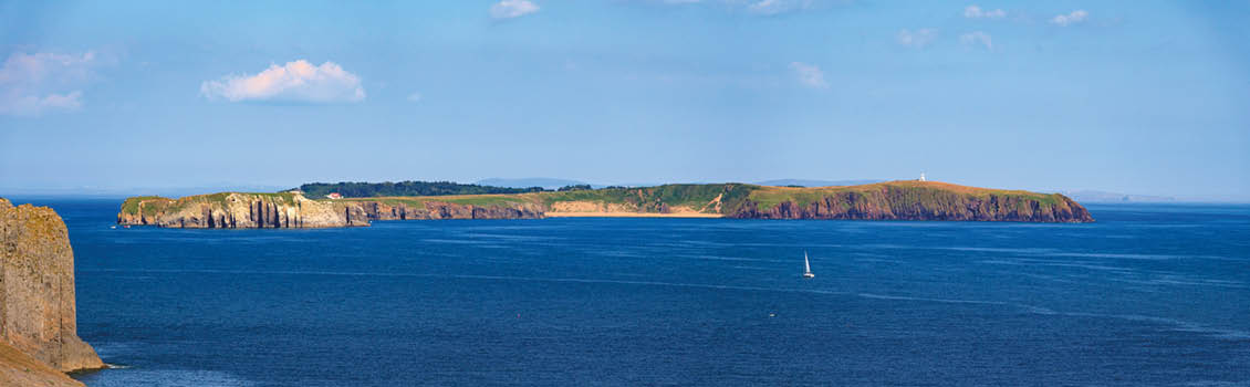
Marloes Sands from headland. © Jane Whaley.
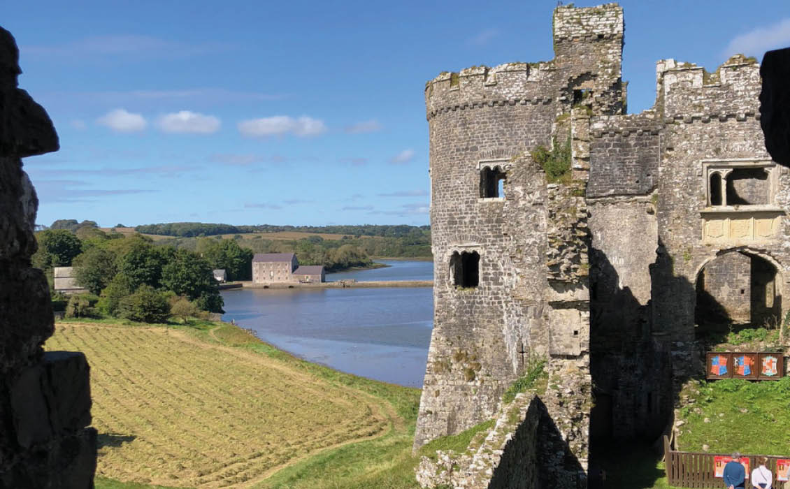
Carew Castle & Watermill. © Jane Whaley.
Acknowledgments
Over the many years of research on the Red Rocks of SW Wales I am indebted to senior research colleagues for their help in the field, their insights into the stratigraphy, sedimentology and tectonics, and their companionship; in particular Professors John Allen (Reading); Paul Hancock (Bristol) and Paul Wright and Susan Marriott (Cardiff).
Additionally, I would like to thank the superb group of Ph.D. students, from Bristol and Aberdeen Universities, I had the privilege to supervise on these rocks: namely Drs. Richard Thomas; John Marshall; Bill Dunne; Janet Almond; Sue Love; Lance Morrissey and, in particular Dr. Rob Hillier who carries on to this day refining the Siluro-Devonian story of south-west Wales. To all of them I owe a great deal of gratitude.
(This article is dedicated to the memory of Professor John Allen FRS – a great friend and close research colleague – who passed away on 18 October, 2020).

Brian Williams is Emeritus Professor of Geology, University of Aberdeen and Adjunct Professor in Geosciences, University College Dublin.

Gareth George began his teaching career in 1969 at Sir John Cass College London and retired in 2004 while at the University of Greenwich. He was also a part-time tutor for the Open University and a consultant to the oil industry.
Brian Williams with John Allen at Freshwater West in 1973.
References
- Allen, J.R.L. 1963. Depositional features of Dittonian rocks: Pembrokeshire compared with Welsh Borderland. Geol. Mag., 100, 385-400.
- Allen, J.R.L. 1985. Marine to fresh water: the sedimentology of the interrupted environmental transition (Ludlow-Siegenian) in the Anglo-Welsh region. Philosophical Transactions of the Royal Society, London B309: 85-104.
- Allen, J.R.L. & Williams, B.P.J. 1978. The sequence of the earlier Lower Old Red Sandstone (Siluro-Devonian), north of Milford Haven, south-west Dyfed Wales. Geological Journal, 13, 113-136.
- Allen, J.R.L. & Williams, B.P.J. 1981a. Sedimentology and stratigraphy of the Townsend Tuff Bed (Lower Old Red Sandstone) in South Wales and the Welsh Borders. Journal of the Geological Society of London, 138, 15-29.
- Allen, J.R.L. & Williams, B.P.J. 1981b. Beaconites antarcticus: a giant channel-associated trace fossil from the Lower Old Red Sandstone of South Wales and the Welsh Borders. Geological Journal, 16, 255-269.
- Allen, J.R.L. & Williams, B.P.J. 1982. The architecture of an alluvial suite: rocks between the Townsend Tuff and the Pickard Bay Tuff Beds (early Devonian), south-west Wales. Philosophical Transactions of the Royal Society, London B287: 51-89.
- Barclay, W.J. & Williams, B.P.J. 2005. Freshwater West, Pembrokeshire. 291-301 in Barclay, W.J., Browne, M.A.E., McMillan, A.A., Pickett, E.A., Stone, P. & Wilby, P.R. The Old Red Sandstone of Great Britain. Geological Review Series. No. 31 (Peterborough: JNCC).
- Barclay, W.J., Davies, J. R., Hillier, R.D. & Waters, R.A. 2015. Lithostratigraphy of the Old Red Sandstone successions of the Anglo-Welsh Basin. British Geological Survey Research Report, RR/14/02, 96pp.
- Dunne, W.M. 1983. Tectonic evolution of SW Wales during the Upper Palaeozoic. Journal of the Geological Society of London, 140, 257-265.
- George, G.T. 2015. The Geology of South Wales: A Field Guide. Geoserv Publishing (2nd. Edn.), 282pp.
- Hancock, P.L., Dunne, W.M. & Tringham, M.E. 1981, Variscan structures in southwest Wales. Geologie Mijnbouw, 60, 81-88.
- Higgs, K.T. 2004. An early Devonian (Lochkovian) microflora from the Freshwater West Formation, Pembroke Peninsula, South Wales. Geological Journal, 39, 359-374.
- Hillier, R.D. & Williams, B.P.J. 2004. Sedimentation and tectonics: the marine Silurian – basal Lower Old Red Sandstone transition in southwest Wales. Geological Journal, 39, 237-256.
- Hillier, R.D. & Williams, B.P.J. 2007. The Ridgeway Conglomerate Formation of SW Wales, and its implications. The end of the Lower Old Red Sandstone? Geological Journal, 42, 55-83.
- Hillier, R.D., Marriott, S.M. & Williams, B.P.J. 2011. Pedogenic and non-pedogenic calcretes in the Devonian Ridgeway Conglomerate Formation of SW Wales: a cautionary tale. in From River to Rock Record: the deposition of fluvial sediments and their subsequent preservation. North, C.P., Leleu, S. & Davidson, S.. SEPM Special Publication, No.97, 311-325.
- Hillier, R.D., Marriott, S.B., Higgs, K.T. & Howells, S. 2019. Catchment inversion during the Silurian of SW Wales: Pediment plains, embryonic drainage networks and incised valley fills in a dryland range front alluvial system. Sedimentary Geology, 387, 126-151.
- Love, S.E. & Williams, B.P.J. 2000. Sedimentology, cyclicity and floodplain architecture in the Lower Old Red Sandstone of SW Wales. in Friend, P.F. & Williams, B.P.J. (eds.) New perspectives on the Old Red Sandstone. Geological Society of London Special Publication, 180, 371-388.
- Marriott, S.B. & Wright, V.P. 2004. Mudrock deposition in an ancient dryland system: Moor Cliffs, Formation, Lower Old Red Sandstone, southwest Wales. Geological Journal, 39, 277-298.
- Marriott, S.B., Wright, V.P. & Williams, B.P.J. 2005. A new evaluation of fining upward sequences in a mud-rock dominated succession of the Lower Old Red Sandstone of South Wales, UK. Spec. Publns int. Ass. Sediment., 35, 517-529.
- Marriott, S.B., Morrissey, L.B. & Hillier, R.D. 2009. Trace fossil assemblages in Upper Silurian tuff beds: evidence of biodiversity in the Old Red Sandstone of southwest Wales, UK. Palaeogeography, Palaeoclimatology, Palaeoecology, 274, 160-172.
- Marriott, S.B. & Hillier, R.D. 2014. Fluvial style in the Lower Old Red Sandstone: examples from southwest Wales, UK. Proc. Geol. Assoc., 125, 534-547.
- Owen, T.R., Bloxam, T.W., Jones, D.G., Walmsley, V.G. & Williams, B.P.J. 1971. Summer (1968) field meeting in Pembrokeshire, South Wales. Proc. Geol. Assoc., 82, 17-60
- Thomas, R.G., Williams,B.P.J., Morrissey, L.B., Barclay, W.J. & Allen, K.C. 2006. Enigma variations: the stratigraphy, provenance, palaeoseismicity and depositional history of the Lower Old Red Sandstone Cosheston Group, south Pembrokeshire, Wales. Geological Journal, 41, 481-536.
- Williams, B.P.J. 1971. Sedimentary features of the Old Red Sandstone and Lower Limestone Shales of south Pembrokeshire, south of the Ritec Fault. in Bassett, D.A, & Bassett, M.G. (eds.) Geological excursions in South Wales and the Forest of Dean. Geol. Ass., South Wales Group, Cardiff, 222-239.
- Williams, B.P.J. 1978. The Old Red Sandstone of the Welsh Borderland and South Wales. in Friend, P.F. & Williams, B.P.J. (eds.) A field guide to the Devonian of Scotland, the Welsh Borderland and South Wales. The Palaeontological Association, London, 55-106.
- Williams, B.P.J., Allen, J.R.L. & Marshall, J.D. 1982. Old Red Sandstone facies of the Pembroke Peninsula, south of the Ritec Fault. in Bassett, M.G. (ed.) Geological excursions in Dyfed, south-west Wales. National Museum of Wales, Cardiff, 151-174.
- Williams, B.P.J., Marriott, S.B. & Hillier, R.D. 2004. The Lower Old Red Sandstone of the Anglo-Welsh Basin: an introduction. Geological Journal, 39, 233-236.
- Williams, B.P.J. & Hillier, R.D. 2004. Variable alluvial sandstone architecture within the Lower Old Red Sandstone, southwest Wales. Geological Journal, 39, 257-275.
- Williams, B.P.J. & George, G.T. 2021. The Red Rocks of Pembrokeshire. Geoserv Publishing. (in press)


