Sailing Through a Subduction Zone
Floating down the Irrawaddy River is a wonderful way to appreciate both the geological and manmade wonders of Myanmar.
Highly oblique convergence where the Indian and Eurasian plates meet has blessed Myanmar with an unusual geography that underpins the region’s rich history. There is no better way to experience this beautiful setting and the country’s spectacular monuments than by floating down the Irrawaddy River from the old imperial capital of Mandalay to Bagan’s extraordinary temple complex and the kaleidoscopic splendour of Shwedagon Pagoda in Yangon.
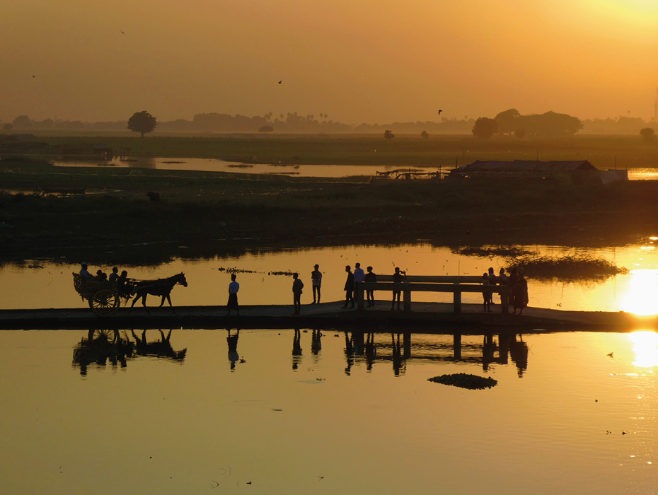
Sunset from the U Bein Bridge in Amarapura. © Lon Abbott and Terri Cook.
From its headwaters in the easternmost Himalaya, the Irrawaddy River flows 2,200 km to its vast delta on the shores of the Andaman Sea. It is along this central artery, which links the cultural centres of Mandalay and Bagan with Yangon, modern Myanmar’s largest city, that the region’s culture and commerce has flowed since well before its inhabitants were first united under the rule of the Bagan Empire in 1044 C.E.
Complex Tectonic Story
The Irrawaddy is a product of the complex and rapidly evolving tectonic configuration in the borderland between the Indian and Eurasian plates, where oblique convergence has occurred since the Mesozoic. Throughout the Early and Middle Cenozoic, today’s central lowlands were home to the Popa volcanic arc and its accompanying forearc and back-arc basins. These were part of an east-dipping subduction zone that carried Indian plate oceanic lithosphere beneath Eurasia’s continental lithosphere.
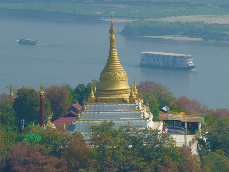
The Irrawaddy River flows past one of the many temples on Sagaing Hill near Mandalay. © Lon Abbott and Terri Cook.
The margin’s strike-slip component of motion was, until the Middle Miocene, distributed across several dextral strike-slip faults located in today’s eastern Myanmar and Thailand. But during the Late Miocene, tectonic adjustments associated with the extrusion of South East Asia eastward, out of India’s path, focused most of that dextral motion onto the 1,500 km-long Sagaing Fault, which passes through Mandalay. Today it is one of the world’s longest and most active strike-slip faults, accommodating more than half of the right-lateral plate motion between India and Eurasia. Transtension associated with the fault’s birth fragmented the former arc complex into a series of north-north-west to south-south-east trending, en-echelon sub-basins drained by the newly born Irrawaddy River. Shortly after, the stress field at this dynamic plate boundary changed again, shifting to transpression. This motion inverted the recently formed basins and built folds that form the long, linear hills that parallel the fault, putting the finishing touches on the diverse landscape that today hosts more than a hundred ethnic groups as well as thousands of monuments honouring the region’s unparalleled history.
We were drawn to visit by tales of Myanmar’s extraordinary Buddhist temples and elaborate pagodas built over many centuries by the Bamar people, the majority ethnic group that has long thrived on the flat, arable land of the 200 km-wide lowlands known as the Central Myanmar Basin. We started our journey in Mandalay, which hosts many monuments due to its long tenure as the seat of government, and from there sailed down the Irrawaddy to Bagan, where thousands of temples from the Bagan Empire are strewn across the semi-arid plain.
Bagan serves as a convenient base to explore not only temples but also the former subduction zone’s volcanic arc and accretionary wedge; the latter forms the stunning Indo-Myanmar Ranges that flank the Irrawaddy River on the west. These ranges are home to the Chin ethnic group, many of whose members still practise their traditional lifeways in remote hill villages. We completed our Irrawaddy adventure by visiting two especially important Buddhist pilgrimage sites near Yangon: the world’s largest pagoda, Shwedagon, and Kyaiktiyo, where a golden boulder remains precariously perched on the edge of a cliff, defying the area’s numerous violent earthquakes to knock it down.
Mandalay: Seat of Royalty
The capital of successive kingdoms that flourished along the Irrawaddy River after the fall of the Bagan Empire remained within a 20-km radius of modern Mandalay from 1313 C.E. until 1885, when the British annexed what they called Burma into the British Empire and moved the capital to Yangon. Today Mandalay, the country’s second city, stands at the southern end of an impressively linear 180 km-long reach of the Irrawaddy, whose arrow-straight course follows the Sagaing Fault.
Mandalay’s long tenure as the seat of royalty has endowed it with an embarrassment of riches, all easily explored on day trips from the city centre. A great place to start is to take the ferry south across the Myitnge River, a major Irrawaddy tributary, and hop into a horse cart for a leisurely tour of Inwa. This rural area was the Kingdom of Ava’s capital city on and off for 360 years, starting in 1365 C.E. Repeated destruction of the city by earthquakes, eight of which are recorded in the kingdom’s history books, played an important role in its shifting fortunes. One Inwa highlight is the Bagaya monastery, which was originally built in 1593 but burned down in 1821. The reconstructed teak monastery is still used as a place of prayer for Buddhist monks and other devout locals.
If you time your visit right, you can also watch the sunset from the famous U Bein Bridge in nearby Amarapura, which became the Konbaung Dynasty’s capital in 1783. The two cities vied as the region’s capital for the next 74 years until King Mindon shifted the seat of power to modern Mandalay in 1857. The palace was relocated, leaving comparatively little to see at Amarapura except the 1.2 km-long bridge, which is said to be the world’s oldest and longest one made of teak.
King Mindon undertook the expensive and arduous relocation of his capital city to the base of Mandalay Hill to fulfil a prophecy that a thriving Buddhist city would be founded at that spot on the 2400th anniversary of Buddhism’s founding. Today you can tour the royal grounds, ascend to the hill’s temple-festooned summit, and visit nearby Kuthodaw Pagoda. This claims to be the world’s largest book because each of its 729 whitewashed kyauksa gu (stoneinscription caves) surrounding the central golden stupa contains a page of the Tripitaka, the holy canon of Theravada Buddhism.
While in Mandalay, it is also worth taking a ferry 11 km up the Irrawaddy to Mingun to see the unfinished hulk of what would have been the world’s largest stupa as well as the 90-tonne Mingun Bell that was meant to hang in it. The stupa was begun by King Bodawpaya in 1790, but was left unfinished when an astrologer foretold that he would die as soon as it was completed. The massive structure is riven by huge cracks formed during the powerful Amarapura earthquake of 1839.
The long, linear Sagaing Hill rises 240m directly across the Irrawaddy from Mandalay. This large pressure ridge, developed by transpression along its namesake fault, is an important religious centre that is adorned with pagodas and monasteries from base to summit. The best view of Sagaing Hill is from the Bagan ferry as it departs Mandalay. Immediately downstream of the city’s two bridges, the river bends west, leaving the Sagaing Fault behind it.
Bagan: Plain of 10,000 Temples
As the ferry drifts down the Irrawaddy to Bagan, it crosses a remnant of the Miocene tectonic configuration: the old back-arc basin that lay east of the Popa volcanic arc. The pancake-flat topography, however, offers no hint of its tectonic origin. The highlight of the eight-hour trip is a stop in the pottery-making village of Yandabo and a demonstration of traditional pot throwing and firing. Soon after departing the village, the ferry reaches the confluence with the Chindwin River and a short distance downstream, hills begin to appear in the distance, signalling that you are now crossing the axis of the Popa volcanic arc. The hazy outline of Popa volcano, a 1,518m-high Quaternary cone, is visible 60 km to the south. Geologists disagree whether this Pleistocene volcano, which lies on the Miocene Popa Arc trend, indicates ongoing subduction or is instead associated with local extension. As the boat continues westward, the river crosses into the forearc basin before docking at Nyaung-U, Bagan’s main town.

Bagan’s temples are especially striking just before sunset. © Lon Abbott and Terri Cook.
This UNESCO World Heritage Site was the seat of the Bagan Empire from 1044–1287 C.E. During those years, devout kings and noblemen constructed more than 10,000 shrines, from the 66m-high Thatbyinnnyu Temple, built by King Sithu I in 1150 C.E., to small personal shrines funded by royal officials and wealthy merchants. Reserve at least two days with a guide to explore some of the many highlights, which range from neglected ruins to carefully maintained shrines still visited by thousands of believers each year.
Another highlight is Shwezigon, a miniature version of Yangon’s gold-leafed Shwedagon Pagoda, as well as sunset viewing of the temples aflame in the last orange rays of the day. One of our favourite sites was the 1113 C.E. Mayazedi Quadrilingual Stone. Housed in the Mayazedi Pagoda, it has the same text inscribed in four different languages: Pali, Pyu, Mon, and Myanmar, and its significance for translating Pali and Pyu is comparable to that of Egypt’s famous Rosetta Stone.
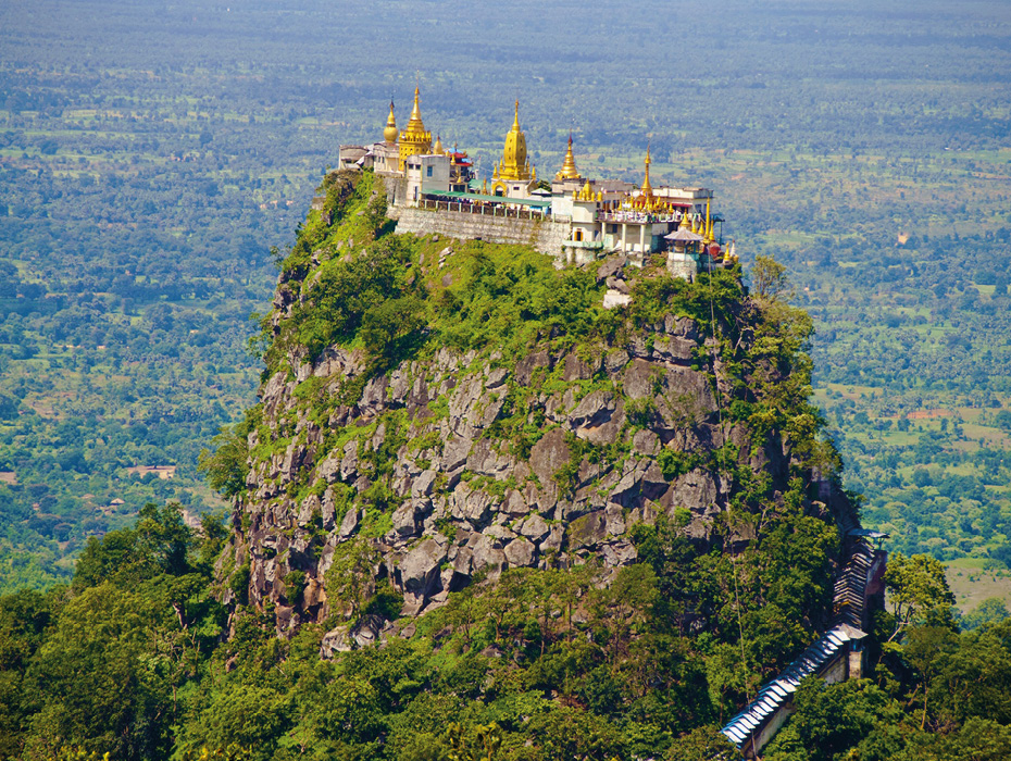
The Buddhist monastery and temple complex of Taung Kalat is perched atop a volcanic plug at Mt. Popa. © Luis Valiente.
A worthwhile day trip is to Popa volcano, the largest feature in the Popa volcanic arc, about 50 km south-east of Bagan. We spent a delightful day hiking through the rainforest, ascending 600m from the Mount Popa Resort to the summit and sharing the trail with Myanmarese school groups and a team of mountain bikers from Yangon. We also toured the Taung Kalat, a precipitous volcanic plug crowned by a Buddhist monastery that is reached by walking (barefoot, as always in Buddhist shrines) up 777 stairs.
Crest of the Indo-Burman Ranges
Bagan, sitting as it does in the forearc basin, is the staging area for a trip up into the Indo-Myanmar Ranges, the homeland of the Chin people and the subduction zone’s accretionary wedge, which was uplifted during the Miocene. One not-to-be-missed sight there is Mount Victoria, the tallest peak in the southern Indo-Myanmar Ranges at 3,063m. Tour agencies in Bagan can arrange a three-day excursion that allows enough time to make the two to three-hour round-trip hike through blooming rhododendron trees to the mist-shrouded summit. While there, we shared the mountain with several enthusiastic groups of shutter-snapping Myanmarese students who had come to see a wild side of Myanmar that was utterly foreign to them.
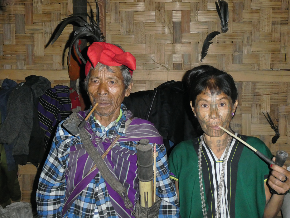
A Chin couple from Kyar Hto village in the Indo-Myanmar range. © Lon Abbott and Terri Cook.
Our trip also included visits to remote villages, where we saw older Chin women with faces scarred by elaborate tattoos and people still living in ways that have barely changed since pre-colonial times. Our friendly Chin driver, who knew the roads and people intimately, took us to a remarkable, out-of-the-way museum of Chin culture in the hill town of Mindat. There the proprietor showed us the accoutrements of Chin warriors, played a song on a traditional nose flute, and toured us through his extensive collection of artefacts spanning the Indo-Myanmar Range’s human history and even pre-history, including mammoth teeth discovered in the region.
Yangon: Two Extraordinary Pagodas
One can take a boat all the way from Bagan to Yangon, but since this takes several days, we chose a one-hour flight instead and settled into our hotel, whose rooftop restaurant had up-close views of 112m-tall Shwedagon Pagoda’s gleaming golden stupa. Located just a few blocks from the hotel, Myanmar’s most sacred Buddhist site enshrines a variety of Buddha relicts. Thousands of devout pilgrims dressed in their finest attire circumambulate the stupa every day, praying in their favourite spots along the route.
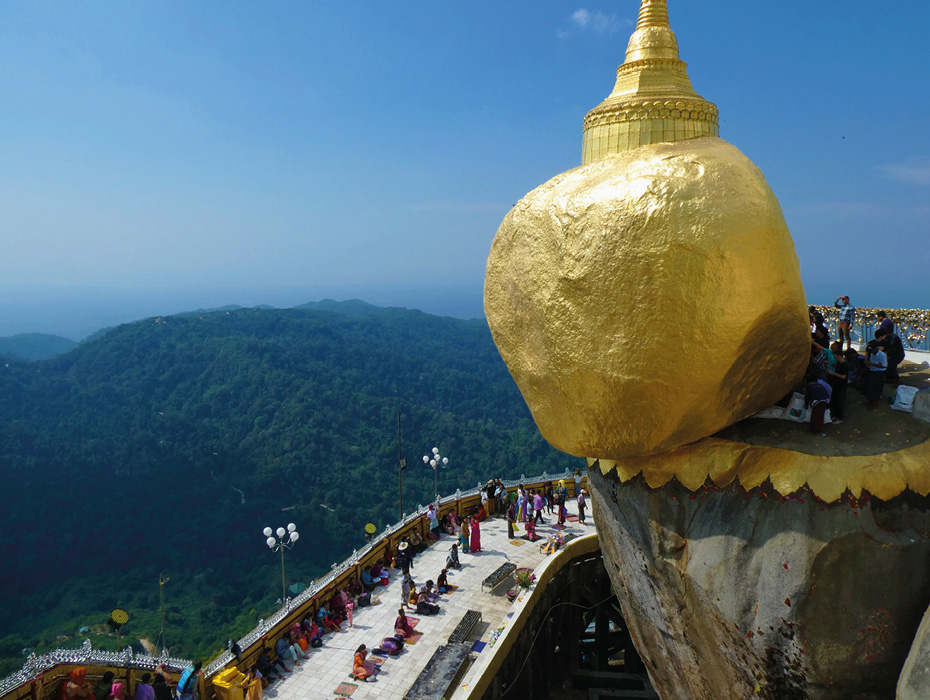
Kyaiktiyo, the Golden Rock pagoda, sits atop a precariously perched boulder. © Lon Abbott and Terri Cook.
Accustomed though we were to the colourful and ornate nature of Myanmar’s shrines, Shwedagon’s exuberant architecture, adorned with gold, glass tiles, mirrors, and flashing LED lights, was a sensory overload. The pagoda’s central stupa has so much gold leaf (at least an estimated nine tonnes) that during British rule it was said that Shwedagon possessed more gold than the Bank of England! As if that was not enough, the spire is encrusted with 5,500 diamonds and 2,300 rubies. Milling with the throngs of Buddhist pilgrims, slowly circling clockwise around the sparkling pagoda, is an unforgettable experience.
We rounded out our trip by travelling 200 km east of Yangon, crossing the Sagaing Fault en route, to Kyaiktiyo (Golden Rock) Pagoda, a small (7.3m) pagoda built atop a massive granite boulder perched at the brink of a cliff. The people of Myanmar are acutely aware of earthquake hazard, so the improbability of this boulder precariously perched at the edge of the abyss is not lost on them. Legend holds that the rock is held in place by a strand of Buddha’s hair, which makes it a major pilgrimage site; another fascinating opportunity to explore the stunning mix of beautiful scenery and ancient and modern culture that characterises the Irrawaddy corridor.
Further Reading on the Hydrocarbon Potential of Myanmar
Rakhine Basin Gas Discovery, Offshore Myanmar
Brought to you in association with NVentures
Korean company Posco International has discovered a new gas field in Myanmar with exploration well Mahar-1, located in offshore Block A3 in the Rakhine Basin.
This article appeared in Vol. 17, No. 3 – 2020
The Geology and Hydrocarbon Potential of Myanmar
Amy Gough, South East Asia Research Group. Royal Holloway, University of London
Despite having a long history in petroleum production – and being the place where the anticlinal trap was first recognised – there is much left to learn about the geology of Myanmar and its remaining hydrocarbon potential.
This article appeared in Vol. 16, No. 1 – 2019


