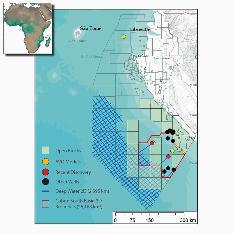
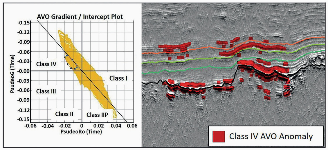
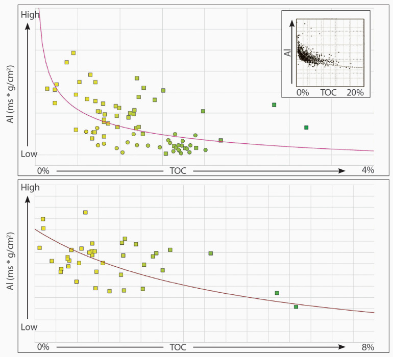
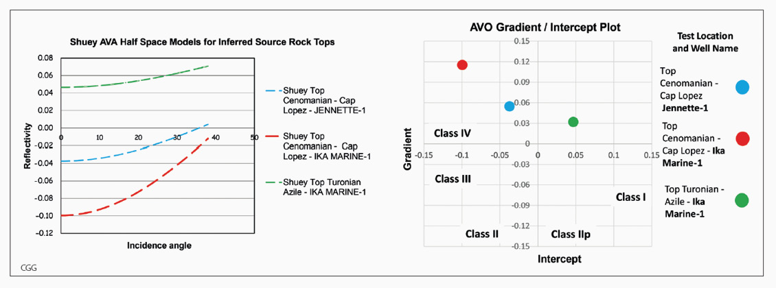
CGG has been investing in Gabon since 1932. Since those early days, the company has moved from the shallow waters, to the shelf and most recently to the thick sedimentary section of the lower slope and abyssal plain. In 2015, CGG acquired 25,168 km2 of 3D BroadSeis™ seismic and potential field data, followed by a further 9,595 km of long-offset 2D seismic data in 2018. To complement its acquisition of geophysical data, CGG has conducted three independent, regional, geological interpretation JumpStart™ projects. These highlight the prospectivity of the targeted geological domain and benefit from the newly acquired geophysical data. Currently, the shallow water shelf plays of Gabon are considered mature. Explorationists have recently followed these plays into deeper waters and enjoyed some success with the drilling of the Boudji-1 and Ivela-1 wells. However, with declining production levels in Gabon and falling drilling prices, explorationists are now looking to open up the inferred ultra-deepwater plays, which have the potential for giant accumulations of hydrocarbons. When CGG acquired its 3D deepwater Gabon South dataset in 2015, an extremely thick section of discontinuous, bright-amplitude reflectors was observed between the seabed and the Top Oligocene unconformity. This section originates from the Congo Fan and pinches out against the palaeoslope, within the 3D survey area. This sedimentary formation expands towards the ultra-deepwater domain, where it thickens up to 4.5 km across the 2D ultra-deepwater survey that CGG acquired in 2018. The section is particularly important as it provides the overburden necessary to mature the inferred, underlying source rocks. This interval also contains key proven seal and reservoir units, as well as a direct hydrocarbon indicator, in the form of a Bottom Simulating Reflector (BSR). As discussed in our previous article Hydrocarbon Potential in Ultra-deep Offshore South Gabon (GEO ExPro 2019, Vol. 16, No. 5), explorers have traditionally targeted structural and stratigraphic combination traps in the post-rift series of the nearby basins (i.e. Gabon North Basin and Lower Congo Basin). A number of fields found in those basins have proven post-rift source rocks, such as the Turonian Azile Formation, the Cenomanian Cap Lopez Formation and the Albian Madiela Formation. In the Gabon South Basin only the syn-rift source rocks of the Melania and Kissenda formations are proven, whilst the post-rift source rocks are inferred. Underlying what we interpret as an Eocene–Oligocene unconformity there is a package of undulating, continuous, parallel reflectors that onlap against a prominent unconformity surface. From our previous studies, this lower unconformity surface allows us to date the package to the Cenomanian–Turonian, an interval in which the inferred Azile and Cap Lopez post-rift source rocks are located. With the same seismic stratigraphic approach, we are able to identify the Albian Madiela Formation which also has potential as a source rock. No well data are available to make a direct tie to these formation markers in the main 2D seismic survey area, but there are known calibration points further to the east where selected lines were extended for that purpose (see map). In addition to stratigraphic relationships, a bright, continuous negative amplitude reflector (indicative of a significant decrease of impedance) exists at the level of all inferred source rock markers. This characteristic, along with pre-stack seismic attributes, helped us to trace the potential source rock intervals throughout CGG’s 2D seismic dataset. Our data suggest that the inferred Albian source rock is confined within small half grabens formed in Aptian-age crust, whilst the Cenomanian–Turonian source rock interval is a much broader regional feature. Studies of Jurassic source rocks from the North Sea (Løseth et al., 2011) have proven that the tops of organic-rich shales can exhibit Class IV Amplitude Versus Offset (AVO) anomaly responses, producing a large decrease of impedance at zero offset that dims with increasing offsets. The effect of this is noticeable with as little as 2% Total Organic Content (TOC). During CGG’s most recent studies offshore Gabon, it was noted that similar effects were visible in the distal seismic data, at the level of the inferred source rock intervals. It is also worth noting that the Jurassic source rocks studied by Løseth et al. consist of a typical Type II kerogen mixture of degraded terrestrial and planktonic marine origin. These were deposited in a similar deepwater marine environment to the Cenomanian–Turonian source rocks encountered offshore Gabon and, based on their geochemistry, they are also commonly classified as Type II. Hence, the work from Løseth et al. provides a good analogue. In order to validate our seismic observations the Jeannette-1, Ika Marine-1 and Aulica Marine-1 wells were used to investigate the relationship between acoustic impedance and TOC. This confirmed an inverse relationship between measured TOC and Acoustic Impedance (AI) for Cenomanian–Turonian and Albian source rocks offshore Gabon, in line with the analogue provided by Løseth et al. Both intervals display inverse power trends, but the mudstone-dominated Turonian Azile and Cenomanian Cap Lopez formations provide a closer fit than the diagenetically altered carbonates of the Albian Madiela Formation. To provide further support for these observations, a series of synthetic Amplitude Versus Angle (AVA) curves were produced to model the response of the top of the source rock interface based on rock physics properties extracted from key well logs (i.e. density, P-wave velocity and S-wave velocity). This was used to test that the AVA response calculated at the wells matches our seismic observations further offshore. Synthetic AVA curves were modelled for the top of the main Cenomanian–Turonian source rock for two wells. The results clearly demonstrate the anticipated Class IV anomaly, similar to previous work on Type II Jurassic source rocks in the North Sea. The slight variations observed can be attributed to facies changes in the overburden and differences in average TOC over the bulk of the source rock interval itself. With the rock physics models extracted from wells that penetrated the source rock intervals, we can now look back at our seismic data to search for a similar response. The intervals mapped as the Cenomanian–Turonian and Albian sequences show both a prominent AI decrease through the top reflection and a clear Class IV AVA anomaly, as illustrated in the seismic foldout. These results support the potential presence of good-quality source rocks at these levels. Given that deepwater marine conditions prevailed throughout the region during the deposition of the Cenomanian–Turonian, it is a fair assumption to extrapolate the response modelled from proximal wells to the more distal areas where our 2D seismic data are located. However, extrapolation of the Albian source rock information is more speculative because shallower marine settings prevailed in the inboard locations of the well control at the time. As a result, the wells used for the rock physics models may not be representative of the more distal marine depositional environment that prevailed over the 2D seismic survey area. The findings of our work show how targeted 2D seismic data acquisition, combined with geological and rock physics studies, can provide a low-cost, powerful tool for explorationists to reduce the uncertainty associated with both source rock presence and quality in unexplored areas, such as the ultra-deep waters offshore Gabon. Hydrocarbon Potential in Ultra-deep Offshore South Gabon
Gabon: Staying ahead of the herd in the ultra-deep waters
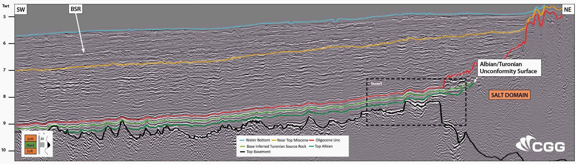 2D seismic dip line offshore Gabon.
De-risking deepwater plays offshore Gabon
A seismic- and well-based approach reduces uncertainty over source rocks to bring insight to the hydrocarbon plays offshore Gabon.
2D seismic data observations
Reducing exploration uncertainty in deepwater Gabon
Implications for inferred distal sources
References
Further reading on CGG seismic coverage in Gabon
Jake Berryman and Gregor Duval, CGG
A new seismic survey and integrated study reveals hydrocarbon potential in the ultra-deep offshore Gabon petroleum systems.
This article appeared in Vol. 16, No. 5 – 2019Related Articles


