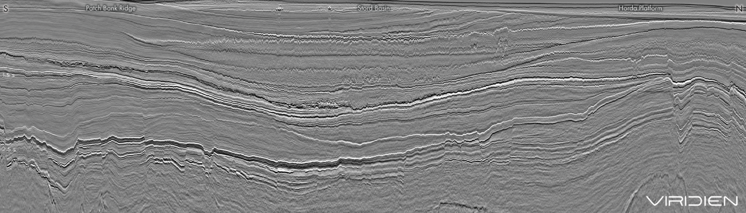
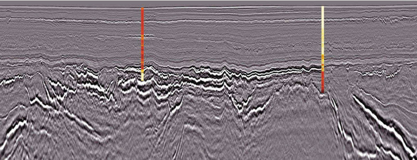
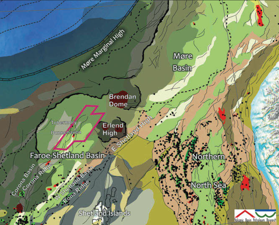
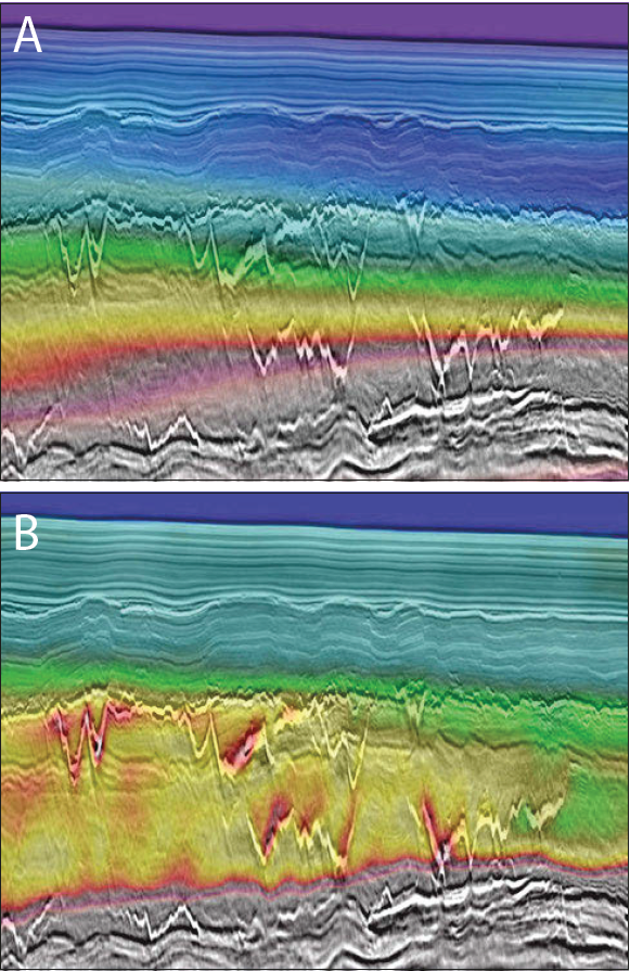
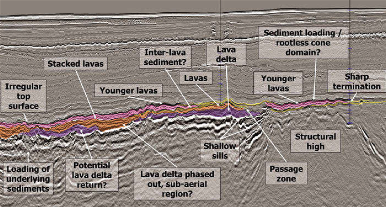
It is something of a surprise to realise that in 2020 we can look back on nearly 60 years of exploration activity in the Faroe-Shetland Basin, which has resulted in the great oil fields such as Clair, Schiehallion and Lancaster. However, in the northern areas, including the Erlend and Brendan basins, only a few exploration wells have been drilled so far, in stark contrast to the well-explored southern part. New interest and efforts are now being made to uncover more hydrocarbons in this area. Several gas discoveries have been proven and new data will certainly help to unlock the full potential. Much of this potential sits between and under volcanic rocks that require new seismic processing technology to be imaged effectively. Over the past decade, TGS has covered the northern Faroe-Shetland Basin with large 3D seismic surveys. The latest of these is the Erlend Wild West 3D, acquired in 2018 (EWW18), which was then merged with the Erlend West 3D survey, acquired in 2012, in a pre-stack depth, merged project. The highlight of this processing work is the use of Reflection Full Waveform Imaging (FWI) and interpreted geomodels of the different volcanic facies, linked to analogues in nearby wells to improve The foldout image shows a 3D view of Cretaceous and Paleogene intervals within the Erlend Basin. Climbing sill intrusions can be seen within the migration velocities. TGS Seismic Foldout from the Erlend Basin. The foldout image shows a 3D view of Cretaceous and Paleogene intervals within the Erlend Basin. Climbing sill intrusions can be seen within the migration velocities. Cretaceous (A). Remobilised Eocene delta sands injected in the younger succession are a potential lead to be evaluated (B) and inter-basalt slow velocity layers point to potential reservoirs between flow basalts (C). Based on new 3D seismic on the North Atlantic margin, it has been possible to map a wider range of volcanic facies in the Faroe-Shetland Basin (FSB) and surrounding area. Large variations in basalt thickness have been mapped and interpreted on the Norwegian side of the margin and linked up to the Erlend Basin in the UK. In particular, the base basalt transition and underlying sedimentary sequences have been a focus, with testing of various processing parameters, including extensive velocity analysis, which has resulted in improved definition of top and base basalt with their related geomorphological features. Furthermore, it has been possible to identify layering and velocity contrasts within the volcanic sequence which affects large parts of the basin area. Locally, the basalt can be very thin or absent, as we can see in places in the Erlend and Brendan Basins, where sub-aerial lava flows, shallow marine flows and debris flows have all been interpreted. Welldefined interfingering of basalt flows and inter-lava sandstone are present in the Rosebank hydrocarbon discovery (Duncan et al., 2009) and new seismic data in the Erlend area reveals several similarities with the Rosebank type of play. Based on a combination of field and seismic examples from mid-Norway and the UK, including borehole data from the Rosebank field in the Faroe-Shetland Basin, it has been possible to identify several volcanic facies that developed in a wet sediment environment. Lava flowing across typically wet, unconsolidated sediments begins to nose beneath the surface (Millett et al., 2019), and examples of this can be interpreted from the new Erlend West 3D survey. A large channel system within the Flett Formation is sand-rich, sourced from the Lewisian gneisses in the Shetland Platform. Sand injectites have increasingly become of interest as exploration targets because of their potential high quality reservoirs. In the FSB study area, sand injectites are penetrated at the Tobermory (214/4-1) and Bunnehaven wells (214/9-1), and the Tobermory gas discovery occurs in a sandstone interval within the Eocene Strachan fan. Sand injectites can be observed directly above this fan coming in from the west, suggesting that many of these injectites are interconnected and might be sourced from the fan. Sand injectites above the Strachan Fan have stronger amplitude responses than those below the fan and are generally distinct singular reflections. They are similar to igneous sills but occur shallower in the geological succession and with a much smaller diameter. Fluid migration associated with hydrothermal vents is typical for the area not covered by lava but where sill intrusions are dominant. Inter-basalt low velocity layers and bright soft reflections suggest the possibility of interfingering sands and Rosebank analogues. The new imaging of the EWW_Merge survey gives better definition of sub-basalt strata that now can be evaluated with reference of traps and leads. The presence of volcanic sills in typically flat mud-dominated basins is a great benefit for the hydrocarbon system. In many places worldwide, it has been demonstrated that the heat from sill emplacement in a low organic shale can produce large quantities of hydrocarbons – typically gas, but also oil. The cooled sill intrusion has cracks and porosity along the surface and in many cases the secondary porosity along the sills is the most porous part of a mud-dominated sequence. Hydrothermal vents create vertical migration paths and can lead the hydrocarbons from deeper source rocks up into shallow and drillable traps. Within this area, Tobermory, along with the Balderbrå and other discoveries in the Norwegian Sea, are good examples of this process. The sill intrusions ‘armour’ the basin, altering the basin stiffness locally and thereby facilitating asymmetrical subsidence that, in turn, creates anticlinal structures that can trap hydrocarbons. In general, sill intrusions in a mud-dominated post-rift basin are mostly positive. The only challenge we have – which is now being addressed – is imaging in between and below the volcanic rocks. With such a complex geology and possibly stacked pay, re-imaging with depth migration was the obvious next step for the area. A TTI (Tilted Transverse Isotropy) KiPSDM route was chosen, with the focus on a very detailed pre-processing sequence and advanced velocity model building. The EWW18 survey was acquired using a triple source set-up. While enabling effective acquisition and reducing environmental footprint but still retaining excellent spatial sampling, multiple source acquisition requires careful de-blending. Therefore, an important step in the pre-processing was to remove the overlapping shots using a sparse inversion method (after Masoomzadeh et al., 2019) and recover the primary energy. In order to eliminate the sidelobes and obtain a broadband frequency content, an inversion approach was used to deghost on the receiver side. Optimal preservation of the low frequencies was instrumental to imaging within and below the sills. In order to correctly image the geology in deep water and with limited offset on older vintages, image-guided tomography and Reflection Full Waveform Inversion were used. Detecting the subtle velocity changes in the shallow section led to an improved imaging of the Balder and Flett Formations and enabled better focus of the deeper units. The interpretation of deep-seated fault blocks can now be made with more confidence. Slow velocity layers between the high velocity lava layers gives hope for interbedded reservoirs, such as in the Rosebank field. Future work will target the sill complex using reverse time migration, which has been successfully applied by TGS in similar settings on the Norwegian continental shelf. This seismic foldout was taken from GEO ExPro Vol. 17, Issue No. 3. You can download the original PDF of the issue here and you will find the higher resolution version of this foldout on pages 42-46.
Geology-driven subsurface imaging in the Faroe-Shetland Basin

Improved seismic imaging reveals hydrocarbon potential in the Faroe-Shetland Basin
Better subsurface imaging tools based on geological models and full waveform inversion reveal further hydrocarbon potential in the Faroe-Shetland Basin
Reservoir trends observed in the Faroe-Shetland Basin
TGS subsurface imaging technology
Related Articles