Traversing the Southern Sierra Nevada
While wandering 240 km across California from Bakersfield to Death Valley, the geotourist can marvel at a range of superlative wonders, from the densest developed oil field to the deepest canyon and the lowest point in the United States.
The journey begins in the lower Sierra foothills at Panorama Park, on a bluff located in north-east Bakersfield overlooking the Kern River oil field. Looking west, it is a wonder that so much working oil field equipment – pumpers, steam generators, and endless miles of pipelines, could be packed onto one field covering just 43 km². Kern River was discovered in 1899 when several men dug 21m into the surface and found oil and the first well was drilled that same year to 120m depth. The field is still producing from the primary reservoir that is Pliocene and Pleistocene in age. Deeper and older pools of Oligocene and Miocene reservoirs were discovered in the 1980s. It is THE DENSEST developed field in California with over 9,000 active wells and is the 5th largest discovered in the US.
Our journey across the Sierra Nevada Mountains starts at the eastern edge of the San Joaquin Valley, California near Bakersfield and ends at Death Valley. Map credit: Google Maps.
Sequoia National Park
The giant General Sherman sequoia. © Thomas Smith.
After passing through these densely packed oilfields and heading northeast, one travels through rich farmland and citrus orchards that thrive in this Mediterranean-type climate. The Quaternary and Holocene sediments of the Central Valley were derived from erosion of the Sierra Nevada Mountains to the east. As the road climbs into the Sierra foothills, farmland gives way to oak and chaparral. After driving up some very curvy and steep roads into conifer forests, you enter Sequoia National Park on the Generals Highway. The park is named after the Sequoiadendron giganteum, or giant Sequoia, and was the country’s second National Park, established in 1890 to protect the trees from logging. The Generals Highway, opened in 1926, enabled visitors to drive their cars into the park.
These giant trees grow along a narrow 420 km strip on the western slopes of the Sierra Nevada Mountains between 1,500 and 2,100m in elevation. The bark of the Sequoia is up to a metre thick, protecting the species from fires and pestilence such as wood-boring beetles. A high presence of tannic acids make the trees extremely hardy. These spectacular trees have a large, shallow root system which collects the nutrients that allow them to grow quite fast and this, coupled with a long life span, allows them to grow to their massive size. A stroll through the Giant Forest at Sequoia National Park leaves one in total awe. This large grove, named by naturalist John Muir in 1875, contains close to half of the Earth’s largest trees. The stand of about 8,000 colossal Sequoia trees is in the heart of the park and remains the wonderful spectacle that Muir viewed nearly 150 years ago.
The General Sherman Tree, located at the north end of the Giant Forest, is THE LARGEST tree and also the largest living organism by volume on the planet. The tree is an incredible 2,100 years old, weighs 1.2 million kilograms, is 84m tall and just over 31m in circumference at its trunk.
Kings Canyon National Park
After leaving the Giant Forest and travelling north-west on the Generals Highway, you enter Kings Canyon National Park. Established in 1940, this park is home to the Earth’s second largest tree, General Grant, and offers a fascinating look into Sierra Nevada geology.
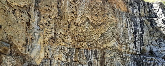
Once into the bottom of Kings Canyon and just upstream from the canyon’s deepest point at 2,442m, is an amazing exposure of the chevron folded, calc-silicate phyllite in the Kings/Kaweah Terrane. This terrane also contains marble that has been cut into numerous caves in Kings Canyon. Boyden Cave is located about 800m downstream. © Thomas Smith.
Upon entering Kings Canyon National Park and driving past Grant’s Grove, the main road descends more than 1,000m down to the bottom of Kings Canyon, THE DEEPEST canyon in North America. Panoramic Point near Grant’s Grove and the Canyon road provide excellent views of Kings Canyon and the high Sierra Nevada, THE LARGEST single mountain range in the lower 48 states.
Over a dozen peaks exceed 4,267m (14,000 ft) in this 600 km-long and 100 km-wide mountain range along the eastern borders of Kings Canyon/Sequoia National Parks. Some of the peaks can be seen from park roads; however, the highest of these and also THE HIGHEST peak in the lower 48 states, Mt. Whitney, cannot be seen from the park. The best views of it are from the east side of the Sierra, west of the small town of Lone Pine in an area called the Whitney Portal. The trail head to the mountain starts at 2,550m and ends at Whitney’s summit at 4,418m.
White Mountains and the Oldest Living Trees
The Sierra Nevada range takes the form of a huge, west-tilted block with steep slopes along the east side bound by a series of active faults. This feature makes the journey east by road from the Kings Canyon/Sequoia area a rather lengthy one to Bakersfield, north-east up the Kern River, and finally into the Owens Valley.
The oldest bristlecone pines grow on the dry, south-facing slopes in a rocky, dolomitic soil that is interlaced with reddish quartzite. These remarkable trees grow very slowly in this high, harsh and cold climate. The wood is very dense and resistant to insects, fungi, rot and erosion. Some of these trees look dead; however, small portions remain living. Erosion exposes the roots of these trees at a rate of about 0.3m per 1,000 years. The person is sitting on an exposed root of this ancient tree. The Sierra Nevada range is in the background, including the southernmost glaciers remaining in the US. © Deborah Bertossa.
Driving north in Owens Valley to the small town of Big Pine offers spectacular views of the massive eastern side of the Sierra Nevada including Mt. Whitney. From Big Pine turn east into the White Mountains where THE OLDEST living non-clonal (individual tree) organism on the planet, the bristlecone (Pinus langaeva) pine tree, inhabits the landscape. (Clonal colonies differ from individual trees in that each tree in a colony is genetically identical and connected via a root system that can be very old. A colony of quaking aspen trees in Utah called Pando is the oldest living organism in the world, being at least 80,000 years old, even though individual trees live only about 130 years.)
Sierra Nevada Geology
Cross section of crustal structure of Sierra Nevada and Basin and Range Province.
A series of terranes (four have been identified in the Kings Canyon area) ranging in age from latest Proterozoic to Triassic-Jurassic comprise the oldest rocks in the Sierra Nevada Mountains. These fault-bound blocks of crust were docked to the North American continent as the floor of the Pacific Ocean was subducted beneath the continental margin. The Sierra Nevada Batholith is also related to subduction along the west coast of North America, being part of a series of batholiths extending from British Columbia to Mexico. The magma was generated from the sinking slab of ocean crust that released superheated water into the overlying continental crust, melting that crust to form granitic plutons that intruded the earlier placed terranes. The intrusions range from latest Triassic to late Cretaceous.
All this tectonic activity resulted in an ancestral mountain range that was deeply eroded during a long tectonic quiescence, exposing the batholithic rocks. By Eocene times, the range had been eroded to a series of low hills. At some time between 10 and 3 Ma, the Sierra block began to rise again. It is believed the uplift was the result of a mantle delamination event, when the eclogite-rich mountain root of the Sierra Nevada broke away and sank into the mantle. Freed of this dense mass of rock, the overlying continental crust buoyed upwards. West-flowing rivers began to cut deep canyons into the underlying rock. Over the last two million years, glaciers have cut into the rocks to form the current alpine topography of rugged horns, arêtes and cirques.
Glaciated exposures of the plutonic rocks of the Sierra Nevada Batholith can be seen near the Sequoia groves and provide excellent viewpoints across the Sierra foothills toward the Central Valley. © Thomas Smith.
Searching for Climate Patterns
A steep and curvy paved road ascends above 3,000m into the White Mountains to the Schulman Grove and visitor centre. This grove encompasses the oldest trees and is named for Dr. Edmund Schulman, a climate scientist who started his career in dendrochronology in 1932 and for the next 20 years conducted climatic research throughout the western states. At that time, tree-ring records only went back a few centuries. Schulman sought to push the science of chronology further into the past.
In his search, he discovered trees dating back nearly 1,000 years. With this longer date, Schulman began to see a 200-year cycle of flood and drought, but he still needed to go back further in time. In 1953, after discovering a limber (Pinus flexilis) pine in Sun Valley, Idaho with 1,700 growth rings, he made a detour to the White Mountains based on a rumour that very old trees existed there. In 1957, Schulman found the world’s oldest living tree ever discovered, a bristlecone pine, subsequently named Methuselah, at 4,723 years. He died a year later at the age of 49 of a fatal heart attack, but brought worldwide attention and protection to these ancient trees. In 2012, THE OLDEST living tree yet discovered was found in the area near the Methuselah tree. Exceeding 5,000 years old, this bristlecone pine germinated approximately 500 years before the construction of the Pyramids of Giza.
Final Destination – Death Valley
All great trips must end somewhere and what better place to end than at THE LOWEST point (86m below sea level) in North America. Badwater Basin in Death Valley National Park is an expansive salt flat, remarkably located only 136.3 km south-east of Mt. Whitney.
From the giant oil fields near Bakersfield, over the high Sierra Nevada Mountains, and descending into Death Valley, the geotourist has witnessed incredible geological and topographic highs and lows, and the largest and oldest living trees on earth. No other place can offer such wonders and spectacular scenes.
References:
Phil Stoffer, 2019, Great Valley Sequence; Regional Geology of North America: Geology and Oceanography Textbooks website, Miracosta Community College, Physical Sciences Department, Oceanside, California: https://gotbooks.miracosta.edu/geology/regions/great_valley.html
Further Reading
The Many Lives of Belridge
Thomas Smith
Nearly declared dead by its owners only eight years after discovery, new technologies introduced over the past century allowed Southern California’s Belridge Field to grow into a prolific oil producer. Now, 101 years since that discovery, innovative insights into its varied reservoirs promise to keep Belridge productive well into the 21st century.
This article appeared in Vol. 9, No. 2 – 2012
California’s Death Valley
Deborah Bertossa and Thomas Smith
The extremes in landscape that characterize Death Valley National Park yield striking landforms, dramatic and colorful scenery, and underlying geologic mystery.
This article appeared in Vol. 4, No. 6 – 2007


