A new regional study of the South-Eastern Caribbean hydrocarbon exploration opportunities using deep seismic imaging. In March 2019 MCG completed acquisition of 16,433 km of long-offset high resolution 2D seismic data in the south-eastern Caribbean. Potential field data were acquired jointly with the seismic. The survey is designed to provide a new, deep, regional seismic and crustal study of the highly prospective yet underexplored basins along the south-eastern Caribbean and Western Atlantic margin off north-east South America. This is an area that holds tremendous hydrocarbon potential with several proven commercial oil and gas fields. The survey area covers Barbados, Grenada, Trinidad and Tobago and St.Vincent, and will provide explorationists with a new view of the regional structure and stratigraphy. Cretaceous La Luna age-equivalent oil-prone source rock is believed to have been identified and it is expected that the La Luna charges prospects in the area. High quality pre-stack time and pre-stack depth data is available, as well as gravity and magnetic data. This survey is in a position to support the upcoming licence bid rounds in Barbados and Trinidad and Tobago. MCG High Resolution 2D Seismic Data South-Eastern Caribbean This seismic foldout was taken from GEO ExPro Vol. 16, Issue No. 6. You can download the original PDF of the issue here and you will find this foldout on pages 42-45. South-Eastern Caribbean Hydrocarbon Exploration Opportunities: A New Regional Study Figure 2: Free air gravity anomaly map. Source: Anderson, 2012. A free air gravity anomaly map shows the major crustal blocks of the south-eastern Caribbean region (Figure 2). The Aves Ridge is expressed as a positive gravity anomaly, while the Grenada and Tobago Basins are expressed as negative anomalies. The crustal variations are probably due to the complex interactions of this triple junction. Rich petroleum systems within this geologically complex region possibly result from this complex plate interaction. New Multiclient 2D Survey Offshore Caribbean The survey was acquired using very long offsets (12 km) and deep records (18 seconds) with a view to providing a deep regional understanding of the entire basin(s) architecture. PSTM data became available in early October 2019, and PSDM will be available in December 2019. The processing sequence used a state-of-the-art broadband solution, and detailed velocity grids were input into both the pre-stack time migration and the pre-stack depth migration. The CAMDI survey can be integrated with the 2013 MCG Barbados MC2D survey and used as an integrated dataset to conduct a regional play fairway analysis, with a view to high-grading prospective exploration areas. The survey provides clear imaging and broad coverage of all play elements in the region, including the oil-prone La Luna source rock or its regional equivalent. New Plays and Large Prospects South-Eastern Caribbean Figure 3: Miocene channels on the Tobago Trough. MCG. The Tobago Trough is an underexplored area flanked by oil and gas production to the east and south in Barbados and Trinidad and Tobago, with a new gas discovery offshore Grenada. Based on an integrated seismic interpretation of the 2013 MCG Barbados MC2D survey and the new CAMDI survey, a thick sedimentary sequence can be observed in the Tobago Trough. During the middle late Miocene, the Orinoco and Amazon rivers drainage systems were created, supplying a large volume of sediments, including high quality, quartz-rich sands, into the deep Caribbean basins. An example of the channels identified within the Miocene section in the Tobago Trough is shown in Figure 3. These channels have distinctive amplitude anomalies, with respect to their surroundings, that may indicate the presence of hydrocarbons within the Miocene channels. Pre-stack depth migration continues, and due to the lack of available well data in the area, a detailed velocity model has been estimated by tomography. The final velocity model is structurally consistent and highly resolved, containing detailed shallow geological features such as mud volcanoes, well-defined faults, and potential gas anomalies (Figure 4). Figure 4: Velocity structure estimated by global tomography from deepwater Trinidad and Tobago to the Tobago Trough. © MCG. La Luna (Equivalent) Source Rock La Luna source rock (or its equivalent) can be interpreted thoughout the entire CAMDI survey (Figures 1 and 5). Basin modelling derived from the 2013 MCG Barbados MC2D survey suggests the presence of the La Luna Formation, or its equivalent within the oil window, along with good quality sandy reservoirs likely originating from the Orinoco Delta. Structural and stratigraphic traps have been mapped and Direct Hydrocarbon Indicators (DHIs) can be observed in connection with many of these traps (Figure 5). The area covered by the new seismic survey is underexplored due to lack of regional deep data. The Tobago Trough has only been tested along the margin in Trinidad and Tobago, and intriguing, deeper oil plays are present in an area soon to be made available for exploration. Figure 5: Deeper seismic reflectors suggest the presence of a La Luna-equivalent source rock. Potential migration paths are possible through the complex folding and faulting system. © MCG. Excellent Hydrocarbon Exploration Opportunity Offshore Caribbean References Advertisement
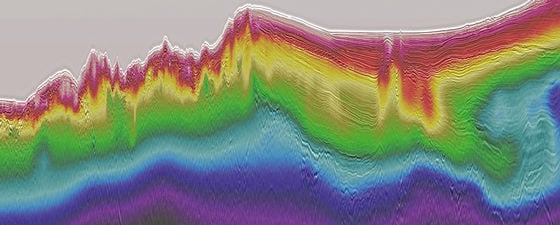
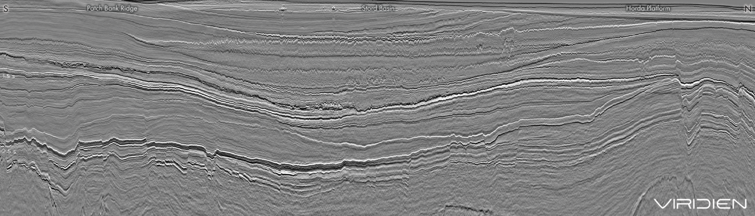
Figure 1: Seismic line extending from the Tobago Trough, though the Accretionary Prism and onto the Atlantic Abyssal Plain.
During the break-up of the supercontinent Pangaea, Barbados was geographically positioned in the southeast corner of the open North Atlantic Basin just prior to the opening of the South Atlantic. At this time, a large seaway opened that extended to the Gulf of Mexico in the Middle Jurassic (roughly 166 million years ago). During the Cenozoic, the Caribbean plate converged obliquely with the North and South American plates. The point of collision shifted from western and central Venezuela in the Paleogene to eastern Venezuela in the Neogene. The Atlantic lithosphere has been subducting beneath the Lesser Antilles throughout these epochs and into the present day. The collision between these plate boundaries created a range of geodynamic processes such as subduction, transpression and transtension, creating a large accretionary ridge which established the regional geology.
During 2018 and the first quarter of 2019, MultiClient Geophysical AS (MCG) acquired the Caribbean Atlantic Margin Deep Imaging seismic survey (CAMDI). This survey consists of 16,433 km of multiclient 2D long-offset seismic data. This transnational survey covers acreage across the maritime borders of Barbados, Trinidad and Tobago, Grenada and St. Vincent. It was designed in two grids. The regional grid is meant to assist exploration companies to gain a betterunderstanding of the regional tectonic framework of the different basins along the south-eastern Caribbean and Western Atlantic Margin of north-east South America. The detailed grid, which covers offshore Trinidad and Tobago and Grenada, is designed to provide more detail, enabling explorationists to outline potential prospects, and ties the producing areas in Trinidad and Tobago to the underexplored deeper part of the Tobago Trough.
All the components for successful exploration are present offshore south-eastern Caribbean. The seismic line shown in Figure 1 (foldout line) is located south of Barbados, running from the Tobago Trough, through the Accretionary Prism and into the Atlantic Abyssal Plain. Several trapping configurations can be identified, including channels, rollover structures and anticlines.
Oil production onshore Barbados commenced in the last century and continues to this day. Barbados production derives from Eocene sandstone reservoirs from the Scotland Group and the sweet, light crude oil is geochemically proven to be from La Luna-equivalent source rocks. Multiple large prospects have already been identified in the regional CAMDI data and ongoing investigations support the theory that the Cretaceous La Luna source rock (or its equivalent) is present, and charging these prospects.
The south-eastern Caribbean area is an excellent exploration opportunity, with only a few exploration wells drilled in this vast, untested area. Several world-class leads have been identified by the new MCG CAMDI seismic data. Deep water licence rounds are anticipated in Barbados and Trinidad and Tobago during the first quarter of 2020. Clearly, good quality offshore reservoirs are evident in the data, optimising the ‘below-ground risk’. In addition, regional governments have developed policies to enhance accessible opportunities, with a view to creating an exploration climate improving the ‘above-ground risk’.
Andersen, O.B., 2012. The DTU10 Gravity field and mean sea surface (2010). In: Second International Symposium of the International Gravity Field Service (IGFS2), (Fairbanks, Alaska)Related Articles