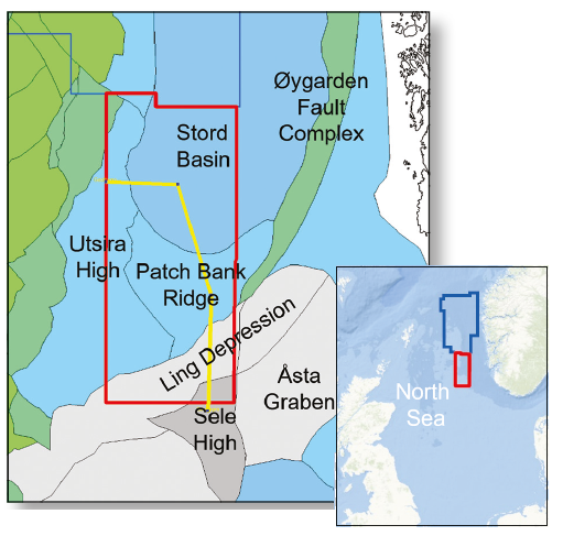
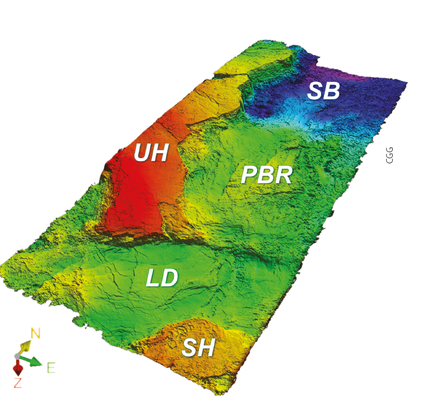
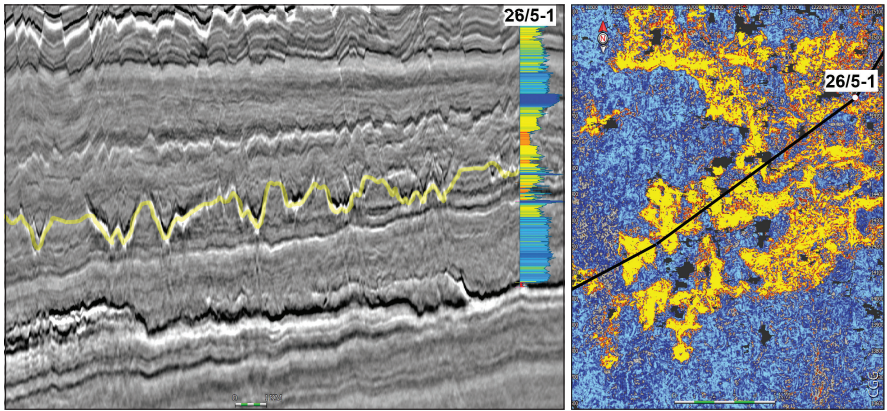
CGG’s broadband seismic data acquisition and advanced imaging technology is driving exploration in the northern Norwegian North Sea. The combination of its North Viking Graben (NVG) and North Viking Graben South (NVGS) surveys, two large continuous and consistent sets of high-quality broadband 3D data totalling 44,000 km2, with revised well and new gravity data, are instrumental in maturing proven exploration models, as well as developing new ones. High-quality seismic data is a key requirement before deciding whether to enter an underexplored province of the North Sea. To help with this process, CGG recently added a southward extension (red polygon, Figure 3) to its existing NVG survey (blue polygon) using its latest broadband seismic acquisition and imaging technology. The resulting state-of-the-art dataset, known as NVGS, reveals detailed stratigraphy from the Permian salt to the Quaternary section for stratigraphic and lithological interpretation. In the seismic section below, old basin con_ gurations can be mapped, including Caledonian folds and faults and Palaeozoic basins. The regional scale of the dataset makes it ideal for establishing a geological model for this region, including prediction of potential source and reservoir rocks. The broadband seismic is complemented by re-evaluated well data, a surface geochemical survey and gravity data. A new regional broadband dataset allows the evaluation of Patch Bank Ridge play elements The application of recent advances in seismic acquisition and imaging technology, such as broadband seismic, to the acquisition of large regional datasets helps the geologist to understand subsurface structure, stratigraphy and rock properties in greater detail. CGG recently acquired a new The Patch Bank Ridge (PBR) is located east of the Utsira High (Figure 4). inning of Palaeozoic to Mesozoic strata onto the Patch Bank Ridge from the north, east and south indicates that it was part of the greater Utsira High until the Mesozoic rifting. The Utsira and the Hardangerfjord Shear Zones, trending north-north-east along the eastern flank of the Utsira High and east-north-east along the northern flank of the Ling Depression respectively, provide the structural framework for the development of Palaeozoic basins in the Patch Bank Ridge area. Fossen (2016) and Fazlikhani et al. (2017) conclude that the Devonian extension known onshore Norway continues into the northern North Sea. The Hardangerfjord Shear Zone shows a similar west-south-west to east-north-east trend to that of the Highland Boundary Fault in the UK. The development of Palaeozoic basins surrounding the Patch Bank Ridge may therefore be comparable to the Palaeozoic basins identified on the UK side of the North Sea, such as the Orcadian Basin. The mapped termination of the Zechstein salt onto the southern flank of the Patch Bank Ridge illustrates the northern termination of a Permian salt basin. The foldout line indicates rift structures and related deposits in the late Permian-early Triassic, with possibly late Permian clastics north of the Patch Bank Ridge. e late Permian-early Triassic east-west extensional rifting phase was followed by a second rift phase that initiated during deposition of the Middle Jurassic and locally affected early Cretaceous strata. The late Permian-early Triassic east-west extensional rifting phase was followed by a second rift phase that initiated during deposition of the Middle Jurassic and locally affected early Cretaceous strata. The late Permian-early Triassic rift is more prominent, setting up the main rift elements, which A local graben similar to the half-grabens on the Utsira High has been identified on the Patch Bank Ridge. The stratigraphy of the Palaeozoic basins identified here is unknown, although in the UK both Devonian and Carboniferous sediments are found in local Palaeozoic basins. In Norway, positive dating of Devonian sediments has been recorded in the Embla Field (Block 2/7), where the sediments are interpreted to have been deposited in a floodplain/lacustrine environment. Carboniferous sediments penetrated in well 2/10-01S are thought to have an alluvial-to-marginal marine depositional environment (Knight et al., 1993). In the re-evaluation of well 25/12-1, the lowermost section has been tentatively assigned to Devonian ‘Old Red Sandstone’, without positive stratigraphic data to confirm dating. The Permian section is believed to consist of a Rotliegende sandstone section and Kupferschiefer and Zechstein evaporites, carbonates and shales (as seen in well 17/4-1 in the Ling Depression), with clastics replacing the salt north of the Ling Depression. The late Permian-Triassic sequences were overlain by a Middle Triassic-Middle Jurassic section of continental-tomarginal marine sediments, followed by a relatively thin late Jurassic-to-earliest Cretaceous sequence. A Cretaceous clastic, carbonate and chalk section is overlain by a thick Cenozoic post-rift sequence. Reservoir – Proven and New Opportunities: Proven reservoirs include the Palaeozoic ones that are producing at the Embla fi eld and the Rotliegende sandstones, which have been penetrated in the Ling Depression. An interesting observation can be made in the Zechstein Salt sequence in the Ling Depression in Figure 5. The ‘channel system’ is associated with the marker that ties with the mid-Zechstein anhydrite-shale and dolomite sequences in well 17/4-1. A possible interpretation for this is a tidal flat environment with channels cutting into the underlying salt. In the Auk Syn-rift reservoirs, with fair-to-good reservoir quality, exist in the late Permian-early Triassic and Middle Jurassic section in the nearby wells. Late Jurassic sand, similar to the sand on the flank of the Utsira High, may be found on the flank of the Patch Bank Ridge and in the local graben. In the late Cretaceous-early Palaeocene Limestone interval, an area of rafted/slumped sediments has been identified and may be of reservoir quality. Injectites and mobilised sand have been identified in the Cenozoic section (Figure 6), in addition to shallow marine and gravity flow sediments. Source: The Critical Component: The Palaeozoic rifts may hold Devonian-Carboniferous source rocks, as seen in the Inner Moray Firth, UK. Oil in the Beatrice field has been analysed to be of Jurassic and Devonian origin. The Devonian setting of the Inner Moray Firth can be compared to the Patch Bank Ridge and its related Palaeozoic basins, with accommodation space for deposition of potential lacustrine source rocks in the local basin centre. Late Cenozoic uplift of the easternmost North Sea has to be considered when estimating the maturity of source rocks. The Jurassic source rocks of the Tau, Bryne and Fjerritslev Formations may be early-to-mature for oil generation. Longdistance migration from the west is possible, and a fi ll-andspill CGG’s 2016 geochemical seafloor study supports the presence of a mature source rock in the basin or long-distance migration from the west into the region. Seal and Trap Identified: Seals on a semi-regional scale are provided by the Zechstein evaporites and shale sequences, Upper Jurassic Draupne Formation and Cretaceous and Cenozoic shale sequences. Traps on the Patch Bank Ridge are rotated fault blocks and incised valleys, with rotated fault blocks on the flank. Downfaulted clastic wedges can be trapped against the Utsira Fault Zone. The Cretaceous-Palaeocene Limestone traps will be stratigraphic, as will the Paleogene and Neogene injectite traps. This new broadband seismic dataset integrated with well, gravity and geochemical data demonstrates the considerable value of high-quality modern seismic data at a regional scale in order to develop new play models and de-risk existing ones. The area to the east of the Utsira High is an underexplored part of the North Sea that warrants new exploration initiatives in the years to come. By taking a regional approach integrating high-quality data, new play models can be developed. For example, the riddles of the Palaeozoic and Mesozoic basins in this area are only partly understood. These could be scrutinised further with the support of the first-class NVGS dataset, benefitting from CGG’s leading seismic technology and geoscience expertise, and by applying models from comparable working petroleum systems.
Norway: new play models for Patch Bank Ridge, East of Utsira High
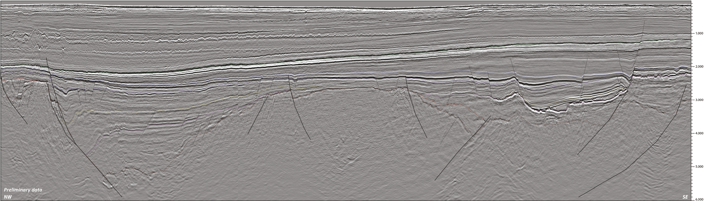 Figure 1: A broadband seismic line running from the Utsira High across the Utsira East Fault System and southwards over the Patch Bank Ridge to the Ling Depression and Sele High in the eastern part of the northern Norwegian North Sea. It displays a detailed stratigraphic section from the Quaternary to the Caledonian faults in basement. The improved resolution compared with older data demonstrates the value of broadband seismic acquisition and imaging.
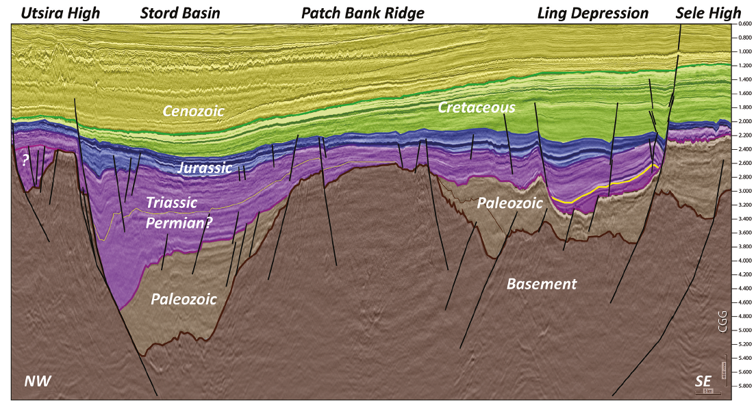
New Insights into Norwegian North Sea
8,600 km2 broadband survey, known as NVGS, in the eastern part of the northern Norwegian North Sea, adding to its existing North Viking Graben (NVG) dataset of over 35,000 km2. It deployed its proprietary BroadSeisTM solution for this survey, combining a unique acquisition technique and high-end imaging technology, to ensure delivery of the highest-quality image.Structural Framework of Patch Bank Ridge.
were reactivated during the late Jurassic.Stratigraphy of PBR and Palaeozoic Basins
New models to be established
field (UK North Sea), the Zechstein stromatolite and dolomudstone that are part of the producing reservoirs are interpreted to have been deposited in an inter-to-supratidal, highly-saline environment similar to the modern sabkhas of the Persian Gulf (Vahrenkamp, 2008).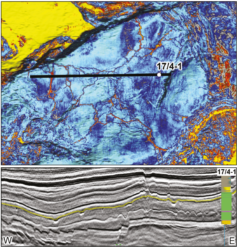
from the Johan Sverdrup fi eld up into younger strata has also been suggested.A Powerful Tool
Related Articles


