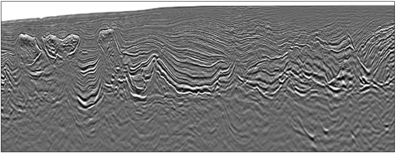
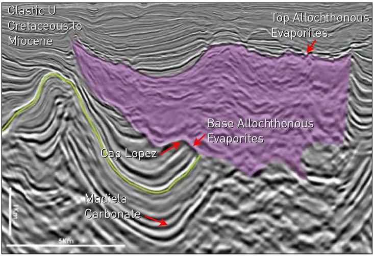
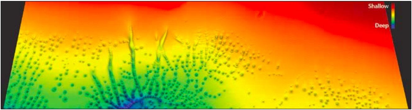
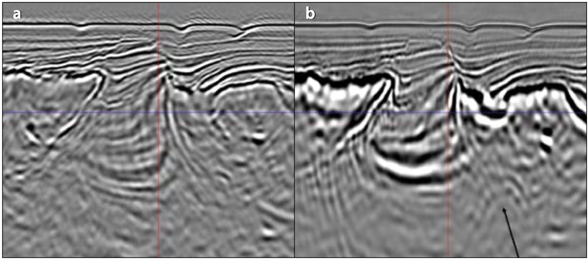
In the early 1990s petroleum industry analysts had begun to refer to the Gulf of Mexico as the Dead Sea, claiming that there were no more large undiscovered resources left (Offshore Magazine, 1997). Exploration was reanimated in 1993 by the lightning strike of the Mahogany subsalt discovery, reflecting huge improvements in seismic imaging. This was followed in 1998 by the Tanzanite and Hickory subsalt discoveries, breathing new life into exploration in the shallow water Gulf of Mexico (Offshore Magazine, 1999). Until now, the salt basin of North Gabon has also been considered to have limited major undrilled potential, and once more this is just a false impression from available seismic imaging under detached salt canopies and overhangs. The lightning has struck again: 3D seismic data acquired in 2018 has yielded unprecedented subsalt imaging, revealing the future Mahoganies, Hickories, Tanzanites and Mad Dogs of West Africa. Stacked depth conformant amplitude anomalies indicating huge hydrocarbon potential similar to the Gulf of Mexico. Traditionally, two separate systems are considered in North Gabon. The deeper of the two is a pre-salt hydrocarbon system comprising the lacustrine Melania and Kissenda source rocks charging both syn-rift Dentale fluvio-deltaic sands and the early post-rift transgressive Gamba sandstone formation. An additional potential source rock, the restricted marine Vembo shale, is ubiquitously encountered sitting above the transgressive Gamba sandstone. A shallower post-salt hydrocarbon system comprises a number of potential source rocks and a series of deltaic clastic reservoirs such as the Ewongue, Anguille, and Cap-Lopez Formations, in drapes, turtle structures and stratigraphic traps generated by salt topology. As confirmed by the 2018 3D seismic data, the distribution of salt is heterogeneous across the area (Figure 2). In the east, salt has mobilised into vertical diapirs leaving a very thin layer between the pre- and post-salt sections. The salt mobilisation reflects both extension of the section as it gently slides down-dip under gravity, and loading from sediment deposited on top. Like pastry in front of a rolling pin, a prograding delta pushes salt in front of it so that, to the west, the salt is still present in extraordinary amounts. Here the salt appears as complex salt walls, domes, canopies and diapirs. This heterogeneous distribution is crucial for exploration. 3D seismic data acquired in 2017–2018 with long 8,000m offset and processed through modern broadband and depth imaging algorithms has successfully targeted the post-rift, as well as the pre-evaporitic syn-rift sequences. More significantly for North Gabon, an unprecedented image of the salt flanks and detached salt bodies has been obtained, largely due to a very carefully derived velocity model (Figure 1). High velocities, which are common in the Lower Madiela, were found in the lower section of the mini-basins. A slow overburden of 2,000-3,000 m/s was juxtaposed on allochthonous salt bodies. Excellent imaging of salt flanks and top and base of allochthonous salt bodies (Figure 3) has allowed the extent of the clastic basins sitting between salt walls (called ‘minibasins’) to be mapped over the entire shallow water North Gabon area for the first time. Over 20 mini-basins with areas up to 370 km2 have been mapped. These provide a staggering total 1,500 km2 area of closure against salt. Subsalt success in the Gulf of Mexico is largely associated with amplitude anomalies and direct hydrocarbon indicators (DHIs). Having looked at hundreds of amplitude and DHI-supported prospects associated with salt in the Gulf of Mexico, the authors of this paper can confirm that amplitude depth conformance is the one factor which can be correlated to the highest success rate. Amplitude stacking has also resulted in some of the most commercial discoveries made in this type of environment. In North Gabon we have observed several DHI types including high amplitude anomalies which stand out strongly against the background, dip inflection points and excitingly, the most wanted prize, stacked depth conformant amplitude anomalies. In the west of the area, where the post-salt mini-basins are thickest, an impressive array of pockmarks has been mapped at the seabed (Figure 4). These are associated with thick postsalt sections, suggesting a post-salt source is working, and also with apparent salt welds connecting pre- and post-salt sections. Faults connect salt welds up to the surface, and soft kick amplitude anomalies are observed in the passage way of fluid pipes, as well as salt flank amplitude anomalies in postsalt thick sections. Very early results obtained for recent least squares Reverse Time Migration (RTM) tests, carried out by DUG (DownUnder GeoSolutions) over a selected area of the 3D, have improved salt imaging even further and have revealed additional prospectivity. There is a clear resemblance to the Mad Dog structure in the GoM (Figure 5). With the area being open acreage in the ongoing licence round, new commercial terms having recently been passed by government, and the imaging for the first time of the sub-salt clastic plays that have provided such a rich harvest in the Gulf of Mexico, North Gabon offers an unparalleled opportunity for lightning to strike again. Modern seismic has brought the prolific GoM subsalt trend to North Gabon, re-energising exploration and welcoming in an era of discovery of the West African Tanzanites, Hickories, Mahoganies and Mad Dogs which have now been revealed. Aiding the Next Steps of Oil and Gas Exploration in the MSGBC Basin The MSGBC Basin Deepwater Kwanza Basin
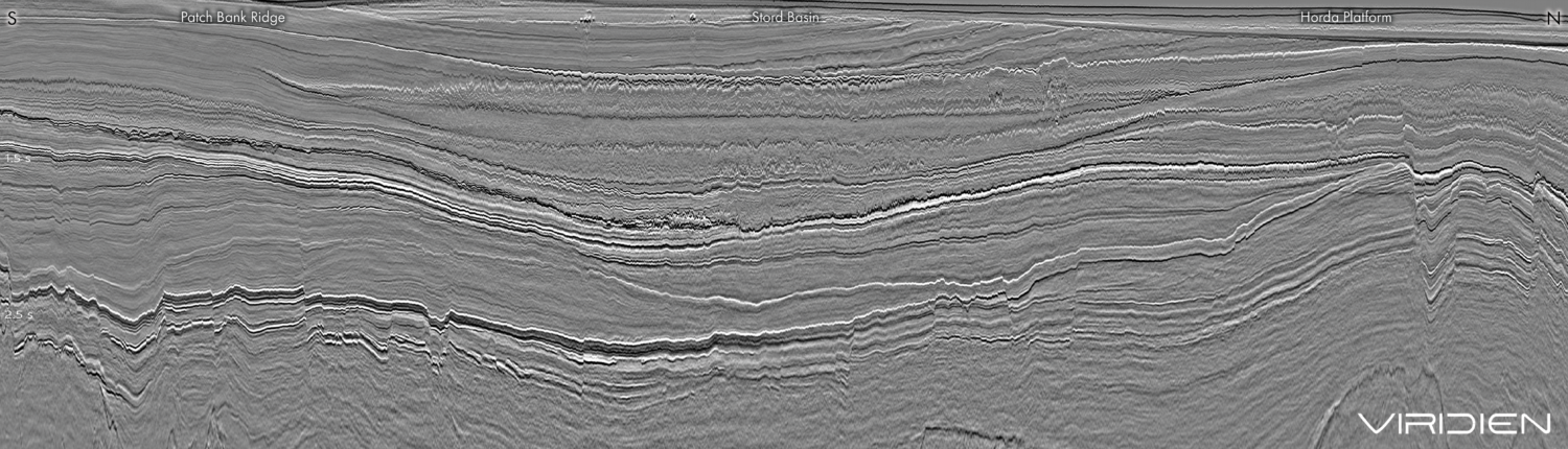
North Gabon: lightning strikes connect the Gulf of Mexico subsalt trend to North Gabon
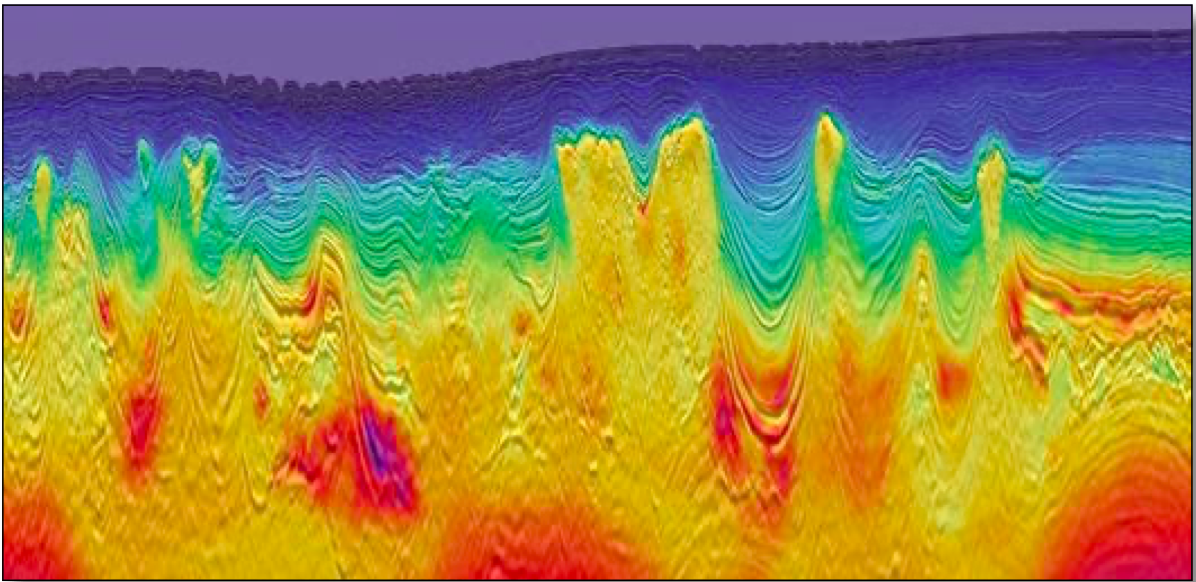
 PSDM line extracted from the TGS North Gabon 3D dataset acquired by Spectrum in 2018. Unprecedented salt flank imaging reveals subsalt and salt flank opportunities in the post-salt while large pre-salt structures are also unveiled. Pockmarks observed at the seabed towards the centre of the section are interpreted as evidence of an active petroleum system.
The tanzanites, hickories, mahoganies and mad dogs of West Africa
Heterogeneous salt distribution in North Gabon
Gulf of Mexico-like subsalt prospectivity revealed
Added hydrocarbon prospectivity in North Gabon revealed
Further Reading on TGS seismic coverage in Africa
TGS
A new integrated approach to oil and gas exploration in the MSGBC Basin, North West Africa.
This article appeared in Vol. 16, No. 5 – 2019
Ben Sayers and Richard Cooke; TGS
TGS basin modelling provides new insights into the MSGBC Basin to help analogue-chasing the next SNE.
This article appeared in Vol. 15, No. 5 – 2018
Cian O’Reilly, Dario Chisari, James Clarke, Sadiqah Musa, Dr. Jennifer Halliday, Ian Deighton , Erika Tibocha and Paul Chandler, TGS
A Prospective Pre-Salt Province?
This article appeared in Vol. 12, No. 5 – 2015Related Articles